https://creativecommons.org/licenses/by/3.0CC BY 3.0 Creative Commons Attribution 3.0 truetrue
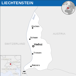
This map is part of a collection of 216 free country maps, created by the UN Office for the Coordination of Humanitarian Affairs (OCHA), to be used in print, web or broadcast products.
The ReliefWeb Location Maps released here are maps that highlight a country, its capital, major populated places and the surrounding regions.
Attribution Requirements
Using the map without modifications: ensure that the sources and the disclaimer are below the map. Credit as follows: "Credit: OCHA".
For use with alteration: remove the OCHA logo and disclaimer following any modification to the map, but keep the data sources as mentioned below the map. Credit the modified map as follows: "Based on OCHA map". You are responsible for the content of your map.
We are keen to receive your feedback and hear how you used OCHA's maps. We would be grateful if you would notify us by e-mail and share your work with us.
UN Disclaimer
The designations employed and the presentation of material of this map do not imply the expression of any opinion whatsoever on the part of the Secretariat of the United Nations concerning the legal status of any country, territory, city or area or of its authorities or concerning the delimitation of its frontiers or boundaries.
ลิงก์ของบันทึก https://ticket.wikimedia.org/otrs/index.pl?Action=AgentTicketZoom&TicketNumber=2014031410007248 Find other files from the same ticket:
Textual information (e.g. timestamp) once visible in the image itself has been moved into the image metadata and/or image description page. This makes the image easier to reuse and more language-neutral, and makes the text easier to process and search for. Commons discourages placing visible textual information in images. All licenses accepted on Commons permit this type of modification as a derivative work. If attribution information were removed and the image is not public domain, replace this tag with {{Attribution metadata from licensed image}}.
беларуская (тарашкевіца) | català | Deutsch | English | español | فارسی | français | galego | magyar | italiano | македонски | മലയാളം | português | русский | sicilianu | slovenščina | Indonesia | 中文 | +/−
ไฟล, liechtenstein, location, 2013, unocha, ไฟล, ประว, ไฟล, หน, าท, ภาพน, การใช, ไฟล, วนกลาง, อม, ลเก, ยวก, บภาพขนาดของต, วอย, าง, ของไฟล, กเซล, ความละเอ, ยดอ, กเซล, กเซล, กเซล, กเซล, กเซล, ภาพท, ความละเอ, ยดส, งกว, 8206, ไฟล, กเซล, ขนาดไฟล, โลไบต, ปภาพหร, อไฟ. ifl prawtiifl hnathimiphaphni karichiflswnklang khxmulekiywkbphaphkhnadkhxngtwxyang PNG nikhxngifl SVG ni 250 250 phikesl khwamlaexiydxun 240 240 phikesl 480 480 phikesl 768 768 phikesl 1 024 1 024 phikesl 2 048 2 048 phikesl duphaphthimikhwamlaexiydsungkwa 8206 ifl SVG 250 250 phikesl khnadifl 948 kiolibt rupphaphhruxiflesiyngni tnchbbxyuthi khxmmxns raylaexiyddanlang epnkhxkhwamthiaesdngphlcak ifltnchbbinkhxmmxns khxmmxnsepnewbistinokhrngkarsahrbekbrwbrwmsuxesri thi khunsamarthchwyid khwamyx khaxthibayLiechtenstein Location Map 2013 LIE UNOCHA svg English Locator map of Liechtenstein wnthi ph s 2556aehlngthima English Liechtenstein Locator Map ReliefWeb ESRI UNCSphusrangsrrkh English UN Office for the Coordination of Humanitarian Affairs OCHA SVG genesisInfoField sxrsokhdkhxng SVG nitrwcsxbthuktxngaelw iflphaphkrafiksewketxrni srangkhunodyich Inkscape This map uses embedded text that can be easily translated using a text editor karxnuyatichsiththi iflnixyuphayitsyyaxnuyatkhriexthifkhxmmxns run aesdngthima 3 0 tnchbbkaraesdngthima OCHAkhunsamarth thicaaebngpn thicathasaena aeckcay aelasngngandngklawtxip thicaeriyberiyngihm thicaddaeplngngandngklaw phayitenguxnikhtxipni aesdngthima khuntxngihekiyrtiecakhxngnganxyangehmaasm odyephimlingkipyngsyyaxnuyat aelarabuhakmikarepliynaeplng khunxacthaechnniidinrupaebbidkidtamkhwr aettxngimichinlksnathiaenawaphuihxnuyatsnbsnunkhunhruxkarichngankhxngkhunhttps creativecommons org licenses by 3 0 CC BY 3 0 Creative Commons Attribution 3 0 true true This map is part of a collection of 216 free country maps created by the UN Office for the Coordination of Humanitarian Affairs OCHA to be used in print web or broadcast products The ReliefWeb Location Maps released here are maps that highlight a country its capital major populated places and the surrounding regions Attribution Requirements Using the map without modifications ensure that the sources and the disclaimer are below the map Credit as follows Credit OCHA For use with alteration remove the OCHA logo and disclaimer following any modification to the map but keep the data sources as mentioned below the map Credit the modified map as follows Based on OCHA map You are responsible for the content of your map We are keen to receive your feedback and hear how you used OCHA s maps We would be grateful if you would notify us by e mail and share your work with us UN Disclaimer The designations employed and the presentation of material of this map do not imply the expression of any opinion whatsoever on the part of the Secretariat of the United Nations concerning the legal status of any country territory city or area or of its authorities or concerning the delimitation of its frontiers or boundaries khxkhwamxnuyatcakecakhxnglikhsiththiihichnganphaphhruxsuxni idrbkartrwcsxbaelw aelathukekbiwinxasasmkhrtxbklbxieml VRT odysahrbphuichthimibychi VRT samarthtrwcsxbbnthukekiywkbkhxkhwamxnuyatnnid inbnthukhmayelkh 2014031410007248 hakthantxngkarnaphaphhruxsuxniipichthixunnxkehnuxcakinmulnithiwikimiediy krunaxankhxmulekiywkbkarnaenuxhaipichnxkmulnithiwikimiediythihnani thngnihakthanprasngkhcakhxkhayunynekiywkbkarxnuyatihichichphaphhruxsuxni krunatidtxphuichthimibychi VRT hruxaecngphanhnaaecng VRT lingkkhxngbnthuk https ticket wikimedia org otrs index pl Action AgentTicketZoom amp TicketNumber 2014031410007248 Find other files from the same ticket Textual information e g timestamp once visible in the image itself has been moved into the image metadata and or image description page This makes the image easier to reuse and more language neutral and makes the text easier to process and search for Commons discourages placing visible textual information in images All licenses accepted on Commons permit this type of modification as a derivative work If attribution information were removed and the image is not public domain replace this tag with Attribution metadata from licensed image belaruskaya tarashkevica catala Deutsch English espanol فارسی francais galego magyar italiano makedonski മലയ ള portugues russkij sicilianu slovenscina Indonesia 中文 khabrryayodyyxithyephimkhabrryaythrrthdediywephuxkhyaykhwamwaiflnimixairixethmthiaesdngxyuiniflniprakxbdwysthanalikhsiththimilikhsiththisyyaxnuyatCreative Commons Attribution 3 0 Unported xngkvsWikimedia VRTS ticket number xngkvs2014031410007248wnthisrang wnkxtng2013MIME type xngkvsimage svg xml prawtiifl khlikwnthi ewlaephuxduiflthipraktinkhnann wnthi ewlarupyxkhnadphuichkhwamehn pccubn20 29 25 minakhm 2559250 250 948 kiolibt Wereldburger758Resized page to drawing Removal watermark Validation of image 11 29 21 emsayn 2557254 254 931 kiolibt UN OCHA maps bot int filedesc Information description en 1 Locator map of Liechtenstein date 2013 source en 1 http reliefweb int map liechtenstein liechtenstein location map 2013 Liechtenstein Locator Map ReliefWeb hnathimiphaphni hnatxipni oyngmathiphaphni praethslichethinchitn karichiflswnklang wikixuntxipniichiflni karichbn bh wikipedia org ल क टन सट इन karichbn ckb wikipedia org لیختنشتاین karichbn en wikipedia org Liechtenstein User PeMSG2000 sandbox karichbn id wikipedia org Liechtenstein Templat Liechtenstein infobox karichbn io wikipedia org Liechtenstein karichbn ne wikipedia org ल स ट नस ट इन karichbn pl wikipedia org Liechtenstein karichbn sco wikipedia org Liechtenstein karichbn sd wikipedia org لچيٽينسٽائين karichbn shn wikipedia org မ င လ ၵ တ ၼ သတ karichbn to wikipedia org Likitenisitaini karichbn zh yue wikipedia org 列支敦士登khxmulekiywkbphaph phaphnimikhxmulephimetim sungswnihymacakklxngdicitxlhruxsaeknenxrthisamarthekbkhxmuldngklawiwrwmkbphaphid thaphaphnithukprbprungaekikhhruxepliynaeplngcakedim khxmulbangxyangcayngkhngimepliynaeplngehmuxnphaphthithukprbprungaekikhnnkhwamkwang250 35225khwamsung250 3125 ekhathungcak https th wikipedia org wiki ifl Liechtenstein Location Map 2013 LIE UNOCHA svg, wikipedia, วิกิ หนังสือ, หนังสือ, ห้องสมุด,