ไม่มีภาพที่มีรายละเอียดสูงกว่านี้
รูปภาพหรือไฟล์เสียงนี้ ต้นฉบับอยู่ที่ คอมมอนส์ รายละเอียดด้านล่าง เป็นข้อความที่แสดงผลจาก ไฟล์ต้นฉบับในคอมมอนส์ คอมมอนส์เป็นเว็บไซต์ในโครงการสำหรับเก็บรวบรวมสื่อเสรี ที่ คุณสามารถช่วยได้
ความย่อ คำอธิบายLower Egypt ancient nomes position map.jpg English:
วันที่ 19 มิถุนายน พ.ศ. 2554, 20:30 (UTC) แหล่งที่มา Egypt_relief_location_map.jpg ผู้สร้างสรรค์ Egypt_relief_location_map.jpg: Eric Gaba (Sting - fr:Sting) and NordNordWest derivative work: Bogomolov.PL (talk )
ภาพนี้ ได้รับการปรับแต่งภาพ Extracted the Lower Egypt area . ต้นฉบับสามารถดูได้ที่นี่: Egypt relief location map.jpg . ปรับแต่งภาพโดย Bogomolov.PL.
ข้าพเจ้า ในฐานะผู้ถือลิขสิทธิ์ของภาพหรือสื่อนี้ อนุญาตให้ใช้ภาพหรือสื่อนี้ภายใต้เงื่อนไขต่อไปนี้
ไฟล์นี้อยู่ภายใต้สัญญาอนุญาต ครีเอทีฟคอมมอนส์ แบบแสดงที่มา-อนุญาตแบบเดียวกัน 3.0 ต้นฉบับ
คุณสามารถ: ที่จะแบ่งปัน – ที่จะทำสำเนา แจกจ่าย และส่งงานดังกล่าวต่อไปที่จะเรียบเรียงใหม่ – ที่จะดัดแปลงงานดังกล่าว ภายใต้เงื่อนไขต่อไปนี้: แสดงที่มา – คุณต้องให้เกียรติเจ้าของงานอย่างเหมาะสม โดยเพิ่มลิงก์ไปยังสัญญาอนุญาต และระบุหากมีการเปลี่ยนแปลง คุณอาจทำเช่นนี้ได้ในรูปแบบใดก็ได้ตามควร แต่ต้องไม่ใช่ในลักษณะที่แนะว่าผู้ให้อนุญาตสนับสนุนคุณหรือการใช้งานของคุณอนุญาตแบบเดียวกัน – หากคุณดัดแปลง เปลี่ยนรูป หรือต่อเติมงานนี้ คุณต้องใช้สัญญาอนุญาตแบบเดียวกันหรือแบบที่เหมือนกับสัญญาอนุญาตที่ใช้กับงานนี้เท่านั้น https://creativecommons.org/licenses/by-sa/3.0 CC BY-SA 3.0 Creative Commons Attribution-Share Alike 3.0 true true อนุญาตให้คัดลอก แจกจ่ายและ/หรือดัดแปรเอกสารนี้ภายใต้เงื่อนไขของสัญญาอนุญาตเอกสารเสรีของกนู รุ่น 1.2 หรือรุ่นใด ๆ นับจากนี้ที่ออกโดยมูลนิธิซอฟต์แวร์เสรี โดยไม่มีส่วนใดห้ามแก้ไข ไม่มีข้อความปกหน้าและปกหลัง สำเนาของสัญญาอนุญาตรวมอยู่ในส่วนชื่อ สัญญาอนุญาตเอกสารเสรีของกนู http://www.gnu.org/copyleft/fdl.html GFDL GNU Free Documentation License true true
คุณสามารถเลือกสัญญาอนุญาตดังกล่าวตามต้องการ
บันทึกการอัพโหลด This image is a derivative work of the following images:
File:Egypt_relief_location_map.jpg licensed with Cc-by-sa-3.0, GFDL 2011-04-18T13:59:05Z Sting 1055x975 (424455 Bytes) Updated after Governorats dissolution 2010-07-19T13:30:06Z Sting 1055x973 (462160 Bytes) Color profile 2010-03-07T19:04:48Z Sting 1055x973 (461278 Bytes) == {{int:filedesc}} == {{Location|26|42|00|N|30|45|00|E|scale:10000000}} {{Information |Description= {{de|Relief Positionskarte von [[:de:Ägypten|Ägypten]]}} {{en|Physical location map of [[:en:Egypt|Egypt]].}} {{fr|Carte Uploaded with derivativeFX
ไทย เพิ่มคำบรรยายทรรทัดเดียวเพื่อขยายความว่าไฟล์นี้มีอะไร
ประวัติไฟล์ คลิกวันที่/เวลาเพื่อดูไฟล์ที่ปรากฏในขณะนั้น
วันที่/เวลา รูปย่อ ขนาด ผู้ใช้ ความเห็น ปัจจุบัน 03:31, 20 มิถุนายน 2554 564 × 249 (28 กิโลไบต์) Bogomolov.PL {{Information |Description={{en|Location map of Lower Egypt <br/> Topographic scale: 1:4,932,000 (precision: 1,233 m)<br/> Equirectangular projection, WGS84 datum<br/> *Standard meridian: 030° 45' E<br/> *Central parallel: 26° 42' N
หน้าที่มีภาพนี้ หน้าต่อไปนี้ โยงมาที่ภาพนี้:
การใช้ไฟล์ส่วนกลาง วิกิอื่นต่อไปนี้ใช้ไฟล์นี้:
Module:Location map/data/Lower Egypt/doc মডিউল:অবস্থান মানচিত্র/উপাত্ত/নিম্ন মিশর মডিউল:অবস্থান মানচিত্র/উপাত্ত/নিম্ন মিশর/নথি নতুন প্রশাসনিক রাজধানী Pyramid of Djoser Suez Pyramid of Unas Pyramid of Neferirkare Battle of Heliopolis Pyramid of Sahure Pyramid of Neferefre Pyramid of Pepi I Pyramid of Djedkare Isesi Environmental issues in Egypt Haïm Capoussi Synagogue El Kurdi Headless Pyramid Module:Location map/data/Lower Egypt/doc User:Maggie39/sandbox Unfinished Pyramid of Abusir User:Archaeobuf/sandbox/hyksos Pyramid of Nyuserre Module:Location map/data/Lower Egypt Fatimid invasion of Egypt (914–915) Fatimid invasion of Egypt (919–921) Fatimid conquest of Egypt Lepsius L Isla Gezira Plantilla:Mapa de localización de Bajo Egipto Nueva Capital Administrativa Pirámide de Pepi I Conquista fatimí de Egipto دمیاط هرم ساحورع هرم نیوسررع هرم جدکاری ایسیسی スエズ ギーザ ディムヤート ポートサイド イスマイリア ดูการใช้ทั่วโลกเพิ่มเติม ของไฟล์นี้
ภาพนี้มีข้อมูลเพิ่มเติม ซึ่งส่วนใหญ่มาจากกล้องดิจิตอลหรือสแกนเนอร์ที่สามารถเก็บข้อมูลดังกล่าวไว้รวมกับภาพได้ ถ้าภาพนี้ถูกปรับปรุงแก้ไขหรือเปลี่ยนแปลงจากเดิม ข้อมูลบางอย่างจะยังคงไม่เปลี่ยนแปลงเหมือนภาพที่ถูกปรับปรุงแก้ไขนั้น
ไฟล, lower, egypt, ancient, nomes, position, ไฟล, ประว, ไฟล, หน, าท, ภาพน, การใช, ไฟล, วนกลาง, อม, ลเก, ยวก, บภาพไม, ภาพท, รายละเอ, ยดส, งกว, าน, lower, egypt, ancient, nomes, position, 8206, กเซล, ขนาดไฟล, โลไบต, ชน, ดไมม, image, jpeg, ปภาพหร, อไฟล, เส, ยงน, . ifl prawtiifl hnathimiphaphni karichiflswnklang khxmulekiywkbphaphimmiphaphthimiraylaexiydsungkwani Lower Egypt ancient nomes position map jpg 8206 564 249 phikesl khnadifl 28 kiolibt chnidimm image jpeg rupphaphhruxiflesiyngni tnchbbxyuthi khxmmxns raylaexiyddanlang epnkhxkhwamthiaesdngphlcak ifltnchbbinkhxmmxns khxmmxnsepnewbistinokhrngkarsahrbekbrwbrwmsuxesri thi khunsamarthchwyid khwamyx khaxthibayLower Egypt ancient nomes position map jpg English Location map of Lower Egypt Topographic scale 1 4 932 000 precision 1 233 m Equirectangular projection WGS84 datum Standard meridian 030 45 E Central parallel 26 42 N Geographic limits of the map Top 31 45 N Bottom 29 00 N Left 027 00 E Right 034 00 E wnthi 19 mithunayn ph s 2554 20 30 UTC aehlngthima Egypt relief location map jpg phusrangsrrkh Egypt relief location map jpg Eric Gaba Sting fr Sting and NordNordWest derivative work Bogomolov PL talk phaphni idrbkarprbaetngphaph sunghmaykhwamwacaidrbkarepliynaeplngphaphtangcaktnchbb karprbprung Extracted the Lower Egypt area tnchbbsamarthduidthini Egypt relief location map jpg prbaetngphaphody Bogomolov PL nbsp khapheca inthanaphuthuxlikhsiththikhxngphaphhruxsuxni xnuyatihichphaphhruxsuxniphayitenguxnikhtxipni iflnixyuphayitsyyaxnuyat khriexthifkhxmmxns aebbaesdngthima xnuyataebbediywkn 3 0 tnchbbkhunsamarth thicaaebngpn thicathasaena aeckcay aelasngngandngklawtxip thicaeriyberiyngihm thicaddaeplngngandngklaw phayitenguxnikhtxipni aesdngthima khuntxngihekiyrtiecakhxngnganxyangehmaasm odyephimlingkipyngsyyaxnuyat aelarabuhakmikarepliynaeplng khunxacthaechnniidinrupaebbidkidtamkhwr aettxngimichinlksnathiaenawaphuihxnuyatsnbsnunkhunhruxkarichngankhxngkhun xnuyataebbediywkn hakkhunddaeplng epliynrup hruxtxetimnganni khuntxngichsyyaxnuyataebbediywknhruxaebbthiehmuxnkbsyyaxnuyatthiichkbnganniethannhttps creativecommons org licenses by sa 3 0 CC BY SA 3 0 Creative Commons Attribution Share Alike 3 0 true true xnuyatihkhdlxk aeckcayaela hruxddaeprexksarniphayitenguxnikhkhxngsyyaxnuyatexksaresrikhxngknu run 1 2 hruxrunid nbcaknithixxkodymulnithisxftaewresri odyimmiswnidhamaekikh immikhxkhwampkhnaaelapkhlng saenakhxngsyyaxnuyatrwmxyuinswnchux syyaxnuyatexksaresrikhxngknuhttp www gnu org copyleft fdl html GFDL GNU Free Documentation License true true khunsamartheluxksyyaxnuyatdngklawtamtxngkar bnthukkarxphohld This image is a derivative work of the following images File Egypt relief location map jpg licensed with Cc by sa 3 0 GFDL 2011 04 18T13 59 05Z Sting 1055x975 424455 Bytes Updated after Governorats dissolution 2010 07 19T13 30 06Z Sting 1055x973 462160 Bytes Color profile 2010 03 07T19 04 48Z Sting 1055x973 461278 Bytes int filedesc Location 26 42 00 N 30 45 00 E scale 10000000 Information Description de Relief Positionskarte von de Agypten Agypten en Physical location map of en Egypt Egypt fr Carte Uploaded with derivativeFXkhabrryayodyyxithyephimkhabrryaythrrthdediywephuxkhyaykhwamwaiflnimixairixethmthiaesdngxyuiniflniprakxbdwysthanalikhsiththimilikhsiththisyyaxnuyatGNU Free Documentation License version 1 2 or later nbsp xngkvsCreative Commons Attribution ShareAlike 3 0 Unported nbsp xngkvswnthisrang wnkxtng19 mithunayn 2011 prawtiifl khlikwnthi ewlaephuxduiflthipraktinkhnann wnthi ewlarupyxkhnadphuichkhwamehn pccubn03 31 20 mithunayn 2554564 249 28 kiolibt Bogomolov PL Information Description en Location map of Lower Egypt lt br gt Topographic scale 1 4 932 000 precision 1 233 m lt br gt Equirectangular projection WGS84 datum lt br gt Standard meridian 030 45 039 E lt br gt Central parallel 26 42 039 N hnathimiphaphni hnatxipni oyngmathiphaphni phiramidenefxrxirkhaer phiramidocesxr suexs karichiflswnklang wikixuntxipniichiflni karichbn azb wikipedia org سوئز شهر کردی دقهلیه karichbn bh wikipedia org Module Location map data Lower Egypt Module Location map data Lower Egypt doc karichbn bn wikipedia org ন ফ র রক র র প র ম ড মড উল অবস থ ন ম নচ ত র উপ ত ত ন ম ন ম শর মড উল অবস থ ন ম নচ ত র উপ ত ত ন ম ন ম শর নথ নত ন প রশ সন ক র জধ ন karichbn en wikipedia org Battle of the Nile Pyramid of Djoser Suez Pyramid of Unas Pyramid of Neferirkare Battle of Heliopolis Pyramid of Sahure Pyramid of Neferefre Pyramid of Pepi I Pyramid of Djedkare Isesi Environmental issues in Egypt Haim Capoussi Synagogue El Kurdi Headless Pyramid Module Location map data Lower Egypt doc User Maggie39 sandbox Unfinished Pyramid of Abusir User Archaeobuf sandbox hyksos Pyramid of Nyuserre Module Location map data Lower Egypt Fatimid invasion of Egypt 914 915 Fatimid invasion of Egypt 919 921 Fatimid conquest of Egypt Lepsius L karichbn es wikipedia org Guiza Isla Gezira Plantilla Mapa de localizacion de Bajo Egipto Nueva Capital Administrativa Piramide de Pepi I Conquista fatimi de Egipto karichbn fa wikipedia org کردی استان دقهلیه دمیاط هرم ساحورع هرم نیوسررع هرم جدکاری ایسیسی karichbn id wikipedia org Penaklukan Fatimiyah atas Mesir karichbn ja wikipedia org アレクサンドリア スエズ ギーザ ディムヤート ポートサイド イスマイリア dukarichthwolkephimetimkhxngiflnikhxmulekiywkbphaph phaphnimikhxmulephimetim sungswnihymacakklxngdicitxlhruxsaeknenxrthisamarthekbkhxmuldngklawiwrwmkbphaphid thaphaphnithukprbprungaekikhhruxepliynaeplngcakedim khxmulbangxyangcayngkhngimepliynaeplngehmuxnphaphthithukprbprungaekikhnn 95 error0 ekhathungcak https th wikipedia org wiki ifl Lower Egypt ancient nomes position map jpg, wikipedia, วิกิ หนังสือ, หนังสือ, ห้องสมุด,
บทความ , อ่าน, ดาวน์โหลด, ฟรี, ดาวน์โหลดฟรี, mp3, วิดีโอ, mp4, 3gp, jpg, jpeg, gif, png, รูปภาพ, เพลง, เพลง, หนัง, หนังสือ, เกม, เกม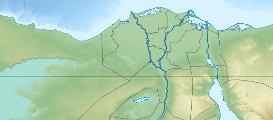