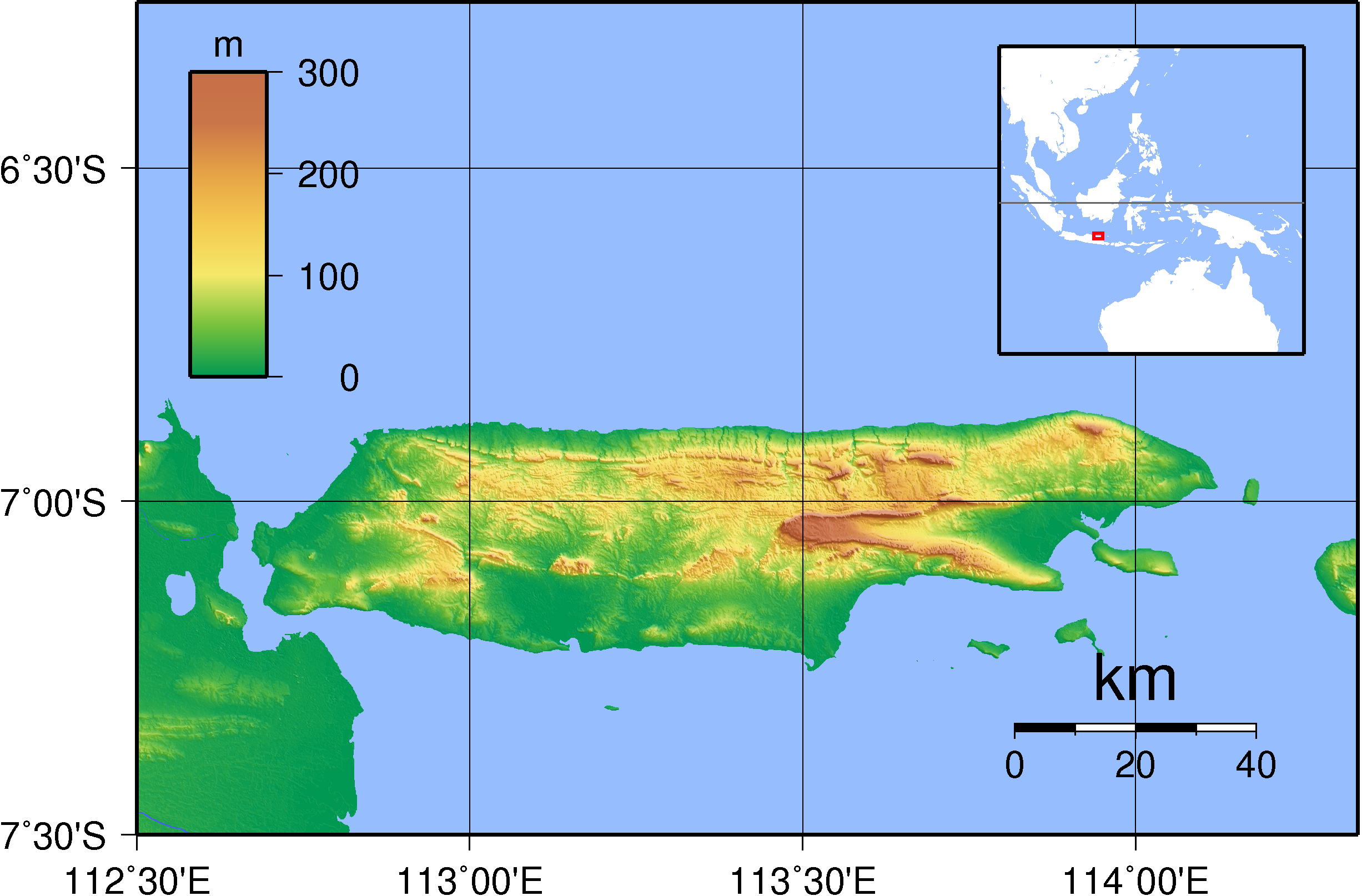
{{Information |Description=Topographic map of Madura, Indonesia. Created with GMT from SRTM data. |Source=self-made |Date=Sep 11, 2007 |Author= Sadalmelik }} Category:Maps of Indonesia Category:Topographic maps of Asia
ไฟล, madura, topography, ไฟล, ประว, ไฟล, หน, าท, ภาพน, การใช, ไฟล, วนกลางขนาดของต, วอย, างน, กเซล, ความละเอ, ยดอ, กเซล, กเซล, กเซล, กเซล, กเซล, ภาพท, ความละเอ, ยดส, งกว, 8206, กเซล, ขนาดไฟล, เมกะไบต, ชน, ดไมม, image, ปภาพหร, อไฟล, เส, ยงน, นฉบ, บอย, คอมมอนส, ร. ifl prawtiifl hnathimiphaphni karichiflswnklangkhnadkhxngtwxyangni 800 526 phikesl khwamlaexiydxun 320 211 phikesl 640 421 phikesl 1 024 674 phikesl 1 280 842 phikesl 2 453 1 614 phikesl duphaphthimikhwamlaexiydsungkwa 8206 2 453 1 614 phikesl khnadifl 1 32 emkaibt chnidimm image png rupphaphhruxiflesiyngni tnchbbxyuthi khxmmxns raylaexiyddanlang epnkhxkhwamthiaesdngphlcak ifltnchbbinkhxmmxns khxmmxnsepnewbistinokhrngkarsahrbekbrwbrwmsuxesri thi khunsamarthchwyid khwamyx khaxthibayMadura Topography png Topographic map of Madura Indonesia Created with GMT from SRTM data wnthi 11 knyayn ph s 2550 aehlngthima ngankhxngtw phusrangsrrkh Sadalmelik karxnuyatichsiththi khapheca inthanaphuthuxlikhsiththikhxngphaphhruxsuxni xnuyatihichphaphhruxsuxniphayitenguxnikhtxipni xnuyatihkhdlxk aeckcayaela hruxddaeprexksarniphayitenguxnikhkhxngsyyaxnuyatexksaresrikhxngknu run 1 2 hruxrunid nbcaknithixxkodymulnithisxftaewresri odyimmiswnidhamaekikh immikhxkhwampkhnaaelapkhlng saenakhxngsyyaxnuyatrwmxyuinswnchux syyaxnuyatexksaresrikhxngknuhttp www gnu org copyleft fdl html GFDL GNU Free Documentation License true true iflnixyuphayitsyyaxnuyatkhriexthifkhxmmxns runaesdngthima xnuyataebbediywkn 3 0 tnchbb 2 5 thwip 2 0 thwip aela 1 0 thwipkhunsamarth thicaaebngpn thicathasaena aeckcay aelasngngandngklawtxip thicaeriyberiyngihm thicaddaeplngngandngklaw phayitenguxnikhtxipni aesdngthima khuntxngihekiyrtiecakhxngnganxyangehmaasm odyephimlingkipyngsyyaxnuyat aelarabuhakmikarepliynaeplng khunxacthaechnniidinrupaebbidkidtamkhwr aettxngimichinlksnathiaenawaphuihxnuyatsnbsnunkhunhruxkarichngankhxngkhun xnuyataebbediywkn hakkhunddaeplng epliynrup hruxtxetimnganni khuntxngichsyyaxnuyataebbediywknhruxaebbthiehmuxnkbsyyaxnuyatthiichkbnganniethannhttps creativecommons org licenses by sa 3 0 CC BY SA 3 0 Creative Commons Attribution Share Alike 3 0 true true khunsamartheluxksyyaxnuyatdngklawtamtxngkarkhabrryayodyyxithyephimkhabrryaythrrthdediywephuxkhyaykhwamwaiflnimixairixethmthiaesdngxyuiniflniprakxbdwyphusrangbangkhathiimmiixethmwikisnethschuxphusrangsrrkh Sadalmelikchuxphuichwikimiediy Sadalmelikyuxaraexl https commons wikimedia org wiki user SadalmeliksthanalikhsiththimilikhsiththisyyaxnuyatCreative Commons Attribution ShareAlike 2 0 Generic nbsp xngkvsCreative Commons Attribution ShareAlike 3 0 Unported nbsp xngkvsGNU Free Documentation License version 1 2 or later nbsp xngkvsCreative Commons Attribution ShareAlike 2 5 Generic nbsp xngkvsCreative Commons Attribution ShareAlike 1 0 Generic nbsp xngkvsthimakhxngiflkarsrangdngedimodyphuxpohldwnthisrang wnkxtng11 knyayn 2007 prawtiifl khlikwnthi ewlaephuxduiflthipraktinkhnann wnthi ewlarupyxkhnadphuichkhwamehn pccubn03 18 12 knyayn 25502 453 1 614 1 32 emkaibt Sadalmelik Information Description Topographic map of Madura Indonesia Created with GMT from SRTM data Source self made Date Sep 11 2007 Author Sadalmelik Category Maps of Indonesia Category Topographic maps of Asia hnathimiphaphni hnatxipni oyngmathiphaphni ekaamadura karichiflswnklang wikixuntxipniichiflni karichbn ace wikipedia org Pulo Madura Pola Madura island infobox karichbn ar wikipedia org جزيرة مادورا karichbn arz wikipedia org مادوريين karichbn az wikipedia org Madura adasi karichbn bn wikipedia org ম দ র দ ব প karichbn ca wikipedia org Illa de Madura karichbn cs wikipedia org Madura karichbn de wikipedia org Madura Insel karichbn el wikipedia org Mantoyra nhsi karichbn en wikipedia org Madura Island Madura Strait karichbn es wikipedia org Isla de Madura karichbn et wikipedia org Madura karichbn fa wikipedia org جزیره مادورا karichbn fr wikipedia org Madura karichbn he wikipedia org ויקיפדיה סדנה לגרפיקה ארכיון 32 karichbn id wikipedia org Pulau Madura Selat Madura Daftar sungai di Madura karichbn ilo wikipedia org Lingsat Madura karichbn ja wikipedia org マドゥラ族 マドゥラ島 karichbn jv wikipedia org Pulo Madura karichbn ka wikipedia org მადურა karichbn ko wikipedia org 마두라섬 karichbn ml wikipedia org മഡ റ ദ വ പ karichbn ms wikipedia org Pulau Madura karichbn nl wikipedia org Madura eiland Straat Madura karichbn nn wikipedia org Madura karichbn no wikipedia org Madura karichbn pl wikipedia org Madura Lista wysp swiata wedlug powierzchni karichbn pnb wikipedia org میڈورا جزیرہ karichbn ru wikipedia org Madurskij proliv Most Suramadu karichbn sl wikipedia org Madurski preliv karichbn sr wikipedia org Madura ostrvo karichbn su wikipedia org Pulo Madura karichbn sw wikipedia org Madura karichbn ta wikipedia org மத ர த வ karichbn te wikipedia org మద ర ద వ ప karichbn ug wikipedia org مادۇرا ئارىلى karichbn uk wikipedia org Madura karichbn vi wikipedia org Madura Eo biển Madura karichbn www wikidata org Q1258905 karichbn zh wikipedia org 马都拉岛 马都拉海峡 ekhathungcak https th wikipedia org wiki ifl Madura Topography png, wikipedia, วิกิ หนังสือ, หนังสือ, ห้องสมุด,