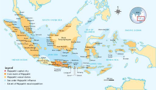
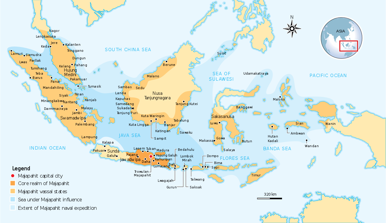
English: The Nusantara Archipelago during the height of Majapahit Empire in XIV century. The red dot is Trowulan; Majapahit capital city. The dark orange area is core realm of Majapahit on eastern part of Java. The light orange area is vassal states of Majapahit mentioned in Nagarakretagama. The pale yellow is outer realm or independent states from Majapahit. The dark cyan is the sea area under influence or effective control of Majapahit. The light cyan is the extent of Majapahit naval expedition.
วันที่
แหล่งที่มา
Own work by uploader, see #References for references used creating the map.
{{Information |Description={{en|1=The Nusantara Archipelago during the height of Majapahit Empire in XIV century. 1. The red dot is Trowulan; Majapahit capital city 2. The dark orange area is core realm of Majapahit on eastern part of Java 3. The light o
ไฟล, majapahit, empire, ไฟล, ประว, ไฟล, หน, าท, ภาพน, การใช, ไฟล, วนกลาง, อม, ลเก, ยวก, บภาพขนาดของต, วอย, าง, ของไฟล, กเซล, ความละเอ, ยดอ, กเซล, กเซล, กเซล, กเซล, กเซล, ภาพท, ความละเอ, ยดส, งกว, 8206, ไฟล, กเซล, ขนาดไฟล, โลไบต, ปภาพหร, อไฟล, เส, ยงน, นฉบ, บอย. ifl prawtiifl hnathimiphaphni karichiflswnklang khxmulekiywkbphaphkhnadkhxngtwxyang PNG nikhxngifl SVG ni 512 297 phikesl khwamlaexiydxun 320 186 phikesl 640 371 phikesl 1 024 594 phikesl 1 280 743 phikesl 2 560 1 485 phikesl duphaphthimikhwamlaexiydsungkwa 8206 ifl SVG 512 297 phikesl khnadifl 524 kiolibt rupphaphhruxiflesiyngni tnchbbxyuthi khxmmxns raylaexiyddanlang epnkhxkhwamthiaesdngphlcak ifltnchbbinkhxmmxns khxmmxnsepnewbistinokhrngkarsahrbekbrwbrwmsuxesri thi khunsamarthchwyid khwamyx khaxthibayMajapahit Empire svg English The Nusantara Archipelago during the height of Majapahit Empire in XIV century The red dot is Trowulan Majapahit capital city The dark orange area is core realm of Majapahit on eastern part of Java The light orange area is vassal states of Majapahit mentioned in Nagarakretagama The pale yellow is outer realm or independent states from Majapahit The dark cyan is the sea area under influence or effective control of Majapahit The light cyan is the extent of Majapahit naval expedition wnthi 10 krkdakhm ph s 2552aehlngthima Own work by uploader see References for references used creating the map phusrangsrrkh Gunawan Kartapranatakarxnuyat karichiflniihm khapheca inthanaphuthuxlikhsiththikhxngphaphhruxsuxni xnuyatihichphaphhruxsuxniphayitenguxnikhtxipniiflnixyuphayitsyyaxnuyat khriexthifkhxmmxns aebbaesdngthima xnuyataebbediywkn 3 0 tnchbbkhunsamarth thicaaebngpn thicathasaena aeckcay aelasngngandngklawtxip thicaeriyberiyngihm thicaddaeplngngandngklaw phayitenguxnikhtxipni aesdngthima khuntxngihekiyrtiecakhxngnganxyangehmaasm odyephimlingkipyngsyyaxnuyat aelarabuhakmikarepliynaeplng khunxacthaechnniidinrupaebbidkidtamkhwr aettxngimichinlksnathiaenawaphuihxnuyatsnbsnunkhunhruxkarichngankhxngkhun xnuyataebbediywkn hakkhunddaeplng epliynrup hruxtxetimnganni khuntxngichsyyaxnuyataebbediywknhruxaebbthiehmuxnkbsyyaxnuyatthiichkbnganniethannhttps creativecommons org licenses by sa 3 0 CC BY SA 3 0 Creative Commons Attribution Share Alike 3 0 true true xnuyatihkhdlxk aeckcayaela hruxddaeprexksarniphayitenguxnikhkhxngsyyaxnuyatexksaresrikhxngknu run 1 2 hruxrunid nbcaknithixxkodymulnithisxftaewresri odyimmiswnidhamaekikh immikhxkhwampkhnaaelapkhlng saenakhxngsyyaxnuyatrwmxyuinswnchux syyaxnuyatexksaresrikhxngknuhttp www gnu org copyleft fdl html GFDL GNU Free Documentation License true truekhunsamartheluxksyyaxnuyatdngklawtamtxngkarewxrchnxun aekikh aekikh Deutsch Bahasa Indonesia English portugues srpski ћirilica 中文 简体 ifl SVG nimikhxkhwamthisamarthaeplid odyichekhruxngmuxaepbphasa SVG hruxichtwaekikh SVG idkid sahrbkhxmulephimetim duthiekiywkbkaraepliflReferences Resources used to create the map 21 mithunayn ph s 2550 Majapahit Kompas Daily Jakarta Indonesia Latif Chalid Irwin Lay ed ph s 2540 Atlas Sejarah Indonesia dan Dunia Historical Atlas of Indonesia and World PT Pembina Peraga Jakarta indonesian IPS Terpadu Sosiologi Geografi Ekonomi Sejarah PT Grafindo Media Pratama p 219 ISBN 9789797583378 khabrryayodyyxithyephimkhabrryaythrrthdediywephuxkhyaykhwamwaiflnimixairixethmthiaesdngxyuiniflniprakxbdwyphusrangbangkhathiimmiixethmwikisnethschuxphuichwikimiediy Gunkartachuxphusrangsrrkh Gunawan Kartapranatayuxaraexl https commons wikimedia org wiki user GunkartasthanalikhsiththimilikhsiththisyyaxnuyatGNU Free Documentation License version 1 2 or later xngkvsCreative Commons Attribution ShareAlike 3 0 Unported xngkvswnthisrang wnkxtng10 krkdakhm 2009 prawtiifl khlikwnthi ewlaephuxduiflthipraktinkhnann wnthi ewlarupyxkhnadphuichkhwamehn pccubn20 07 28 tulakhm 2559512 297 524 kiolibt GunkartaCorrection on Luwu location 17 13 5 phvscikayn 2552781 457 525 kiolibt GunkartaCorrected the location of Malano in northeast coast of Borneo and Wanin Onin in Papua today Fak fak 22 43 10 singhakhm 2552781 457 525 kiolibt GunkartaCrop the map again 22 37 10 singhakhm 2552781 463 529 kiolibt GunkartaCrop the map 22 27 10 singhakhm 2552986 610 582 kiolibt Gunkarta Information Description en 1 The Nusantara Archipelago during the height of Majapahit Empire in XIV century 1 The red dot is Trowulan Majapahit capital city 2 The dark orange area is core realm of Majapahit on eastern part of Java 3 The light o hnathimiphaphni hnatxipni oyngmathiphaphni xanackrmchpahit karichiflswnklang wikixuntxipniichiflni karichbn ar wikipedia org ماجاباهيت karichbn arz wikipedia org امبراطورية ماجاباهيت karichbn ast wikipedia org Imperiu mayapajit karichbn ba wikipedia org Madzhapahit karichbn bg wikipedia org Madzhapahit karichbn bn wikipedia org ব ল বত ক ত মজপহ ৎ karichbn ca wikipedia org Majapahit karichbn cs wikipedia org Madzapahit karichbn de wikipedia org Wikipedia Kartenwerkstatt Archiv 2010 05 karichbn en wikipedia org Majapahit Nusantara archipelago Nagarakretagama Javanisation User Joelton Ivson Gather lists 24371 Indonesia User Tisquesusa sandbox9 User DyinRich Something Else Territories of Majapahit karichbn eu wikipedia org Majapahit Inperioa karichbn fa wikipedia org امپراتوری ماجاپاهیت karichbn fi wikipedia org Majapahit Kayttaja ZacheBot hakemisto SKIPPED Kayttaja ZacheBot hakemisto Historialliset valtiot Islam Indonesiassa karichbn fr wikipedia org Majapahit Nagarakertagama karichbn he wikipedia org מג פהיט karichbn hi wikipedia org मज पह त स म र ज य karichbn id wikipedia org Suku Banjar Wilayah Majapahit karichbn id wikisource org Portal Indonesia karichbn it wikipedia org Majapahit karichbn ja wikipedia org カースト マジャパヒト王国 帝国の最大領域一覧 モンゴルのジャワ侵攻 karichbn km wikipedia org អ ណ ចក រមច ឆប ហ ត karichbn ko wikipedia org 마자파힛 제국 karichbn lt wikipedia org Madzapahitas karichbn ml wikipedia org മജപഹ ത നഗരക ര ത ഗ മ karichbn mr wikipedia org मज पह त karichbn ms wikipedia org Nusantara karichbn nl wikipedia org Majapahit karichbn no wikipedia org Majapahit karichbn pam wikipedia org Nagarakretagama karichbn pl wikipedia org Majapahit Lista najwiekszych panstw w historii Kalendarium historii Indonezji karichbn ru wiktionary org Nusantara karichbn simple wikipedia org Majapahit dukarichthwolkephimetimkhxngiflnikhxmulekiywkbphaph phaphnimikhxmulephimetim sungswnihymacakklxngdicitxlhruxsaeknenxrthisamarthekbkhxmuldngklawiwrwmkbphaphid thaphaphnithukprbprungaekikhhruxepliynaeplngcakedim khxmulbangxyangcayngkhngimepliynaeplngehmuxnphaphthithukprbprungaekikhnnkhwamkwang100 khwamsung100 ekhathungcak https th wikipedia org wiki ifl Majapahit Empire svg, wikipedia, วิกิ หนังสือ, หนังสือ, ห้องสมุด,