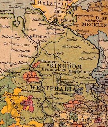
This image is a copy or a derivative work of central_europe_1812.jpg, from the map collection of the Perry–Castañeda Library (PCL) of the University of Texas at Austin. This tag does not indicate the copyright status of the attached work. A normal copyright tag is still required. See Commons:Licensing for more information.
From The Historical Atlas by William R. Shepherd, 1926.
ผู้สร้างสรรค์
William Robert Shepherd (1871–1934)
ชื่ออื่น
William R. Shepherd; William Shepherd
คำอธิบาย
American cartographer และ historian
วันเกิด/วันเสียชีวิต
12 มิถุนายน พ.ศ. 2414
7 มิถุนายน พ.ศ. 2477
สถานที่เกิด/สถานที่เสียชีวิต
ชาร์ลสตัน
เบอร์ลิน
สถานที่สร้างสรรค์งาน
นครนิวยอร์ก
งานควบคุมรายการหลักฐาน
: Q8017647
VIAF: 100210280
ISNI: 0000 0001 2103 3838
Open Library: OL163043A
LCCN: n85234631
GND: 131751212
WorldCat
creator QS:P170,Q8017647
การอนุญาต (การใช้ไฟล์นี้ใหม่)
PCL states map is PD
การอนุญาตใช้สิทธิ
Public domainPublic domainfalsefalse
https://creativecommons.org/publicdomain/mark/1.0/PDMCreative Commons Public Domain Mark 1.0falsefalse
Public domainPublic domainfalsefalse
บันทึกการอัพโหลด
Originally from nl.wikipedia; description page is/was here.
(All user names refer to nl.wikipedia)
2004-08-16 09:49 Känsterle 348×409×8 (69732 bytes) Koninkrijk Westfalen - vrij te gebruiken voor educatieve doeleinden - http://www.lib.utexas.edu/maps/historical/
Map of the principality (later free state) of Lippe 1815–1945. From German Wikipedia and according to information there "Gemeinfrei" = public domain. {{PD-user|Störfix}}
ไฟล, kingdom, westphalia, ไฟล, ประว, ไฟล, หน, าท, ภาพน, การใช, ไฟล, วนกลาง, อม, ลเก, ยวก, บภาพไม, ภาพท, รายละเอ, ยดส, งกว, าน, kingdom, westphalia, 8206, กเซล, ขนาดไฟล, โลไบต, ชน, ดไมม, image, jpeg, ปภาพหร, อไฟล, เส, ยงน, นฉบ, บอย, คอมมอนส, รายละเอ, ยดด, านล, . ifl prawtiifl hnathimiphaphni karichiflswnklang khxmulekiywkbphaphimmiphaphthimiraylaexiydsungkwani Map Kingdom of Westphalia jpg 8206 348 409 phikesl khnadifl 68 kiolibt chnidimm image jpeg rupphaphhruxiflesiyngni tnchbbxyuthi khxmmxns raylaexiyddanlang epnkhxkhwamthiaesdngphlcak ifltnchbbinkhxmmxns khxmmxnsepnewbistinokhrngkarsahrbekbrwbrwmsuxesri thi khunsamarthchwyid khwamyx khaxthibayMap Kingdom of Westphalia jpg Nederlands Koninkrijk Westfalenwnthi 2468 hrux 2469aehlngthima This image is a copy or a derivative work of central europe 1812 jpg from the map collection of the Perry Castaneda Library PCL of the University of Texas at Austin This tag does not indicate the copyright status of the attached work A normal copyright tag is still required See Commons Licensing for more information From The Historical Atlas by William R Shepherd 1926 phusrangsrrkh William Robert Shepherd 1871 1934 chuxxun William R Shepherd William Shepherdkhaxthibay American cartographer aela historianwnekid wnesiychiwit 12 mithunayn ph s 2414 7 mithunayn ph s 2477 sthanthiekid sthanthiesiychiwit charlstnebxrlinsthanthisrangsrrkhngan nkhrniwyxrk ngankhwbkhumraykarhlkthan Q8017647 VIAF 100210280 ISNI 0000 0001 2103 3838 Open Library OL163043A LCCN n85234631 GND 131751212 WorldCat creator QS P170 Q8017647karxnuyat karichiflniihm PCL states map is PD karxnuyatichsiththi Public domain Public domain false falsephusrangsrrkhnganniesiychiwitinpi kh s 1934 dngnnngannicungepnsatharnsmbti inpraethstnkaenidaelapraethsxun thirayaewlakarkhumkhrxnglikhsiththinxykwa 80 pihlngcakphusrangsrrkhnganesiychiwit nxkcaknikhunxactxngephimpaysatharnsmbtiinshrthxemrika ephuxrabuwaehtuidngannicungepnsatharnsmbtiinshrthxemrika oprdthrabwabangpraethsmikhxkahnderuxngkarkhumkhrxnglikhsiththinankwa 80 pi echn emksiok 100 pi caemka 95 pi phaphnixacimepnsatharnsmbtiinpraethsehlanisungimidbngkhbichkdrayaewlakhumkhrxnglikhsiththithisnkwa praethsoktdiwwrmirayaewlakhumkhrxnglikhsiththithwip 99 pi aetimidichkdrayaewlakhumkhrxnglikhsiththithisnkwaiflniidthukrabuwaimmikhxcakdphayitkdhmaylikhsiththi rwmthungsiththithiekiywkhxngaelathiiklekhiyngknhttps creativecommons org publicdomain mark 1 0 PDM Creative Commons Public Domain Mark 1 0 false falsePublic domain Public domain false falseThis work is in the public domain because it was published in the United States between 1928 and 1963 and although there may or may not have been a copyright notice the copyright was not renewed For further explanation see Commons Hirtle chart and the copyright renewal logs Note that it may still be copyrighted in jurisdictions that do not apply the rule of the shorter term for US works depending on the date of the author s death such as Canada 50 years p m a Mainland China 50 years p m a not Hong Kong or Macao Germany 70 years p m a Mexico 100 years p m a Switzerland 70 years p m a and other countries with individual treaties العربية Deutsch English espanol francais galego italiano 日本語 한국어 makedonski portugues portugues do Brasil russkij sicilianu ukrayinska 简体中文 繁體中文 bnthukkarxphohld Originally from nl wikipedia description page is was here All user names refer to nl wikipedia 2004 08 16 09 49 Kansterle 348 409 8 69732 bytes Koninkrijk Westfalen vrij te gebruiken voor educatieve doeleinden http www lib utexas edu maps historical Map of the principality later free state of Lippe 1815 1945 From German Wikipedia and according to information there Gemeinfrei public domain PD user Storfix khabrryayodyyxithyephimkhabrryaythrrthdediywephuxkhyaykhwamwaiflnimixairixethmthiaesdngxyuiniflniprakxbdwywnthisrang wnkxtng1926 prawtiifl khlikwnthi ewlaephuxduiflthipraktinkhnann wnthi ewlarupyxkhnadphuichkhwamehn pccubn16 38 4 minakhm 2550348 409 68 kiolibt SieBot Information Description Koninkrijk Westfalen PD PCL central europe 1812 jpg historical shepherd Source Originally from http nl wikipedia org nl wikipedia description page is was http nl wikipedia org w index php title Image 3AKWestfale hnathimiphaphni hnatxipni oyngmathiphaphni rachxanackrewsthfaelin karichiflswnklang wikixuntxipniichiflni karichbn ca wikipedia org Regne de Westfalia karichbn el wikipedia org Basileio ths Bestfalias karichbn eo wikipedia org Reĝlando Vestfalio karichbn et wikipedia org Vestfaali kuningriik karichbn fa wikipedia org پادشاهی وستفالیا karichbn he wikipedia org ממלכת וסטפאליה karichbn id wikipedia org Kerajaan Westfalen karichbn it wikipedia org Regno di Vestfalia karichbn ro wikipedia org Regatul Westfaliei karichbn sr wikipedia org Kraљevina Vestfaliјa karichbn zh wikipedia org 威斯特法倫王國khxmulekiywkbphaph phaphnimikhxmulephimetim sungswnihymacakklxngdicitxlhruxsaeknenxrthisamarthekbkhxmuldngklawiwrwmkbphaphid thaphaphnithukprbprungaekikhhruxepliynaeplngcakedim khxmulbangxyangcayngkhngimepliynaeplngehmuxnphaphthithukprbprungaekikhnn error0 ekhathungcak https th wikipedia org wiki ifl Map Kingdom of Westphalia jpg, wikipedia, วิกิ หนังสือ, หนังสือ, ห้องสมุด,