Alemannisch ∙ Bahasa Indonesia ∙ Bahasa Melayu ∙ British English ∙ català ∙ čeština ∙ dansk ∙ Deutsch ∙ eesti ∙ English ∙ español ∙ Esperanto ∙ euskara ∙ français ∙ Frysk ∙ galego ∙ hrvatski ∙ Ido ∙ italiano ∙ lietuvių ∙ magyar ∙ Nederlands ∙ norsk bokmål ∙ norsk nynorsk ∙ occitan ∙ Plattdüütsch ∙ polski ∙ português ∙ português do Brasil ∙ română ∙ Scots ∙ sicilianu ∙ slovenčina ∙ slovenščina ∙ suomi ∙ svenska ∙ Tiếng Việt ∙ Türkçe ∙ vèneto ∙ Ελληνικά ∙ беларуская (тарашкевіца) ∙ български ∙ македонски ∙ нохчийн ∙ русский ∙ српски / srpski ∙ татарча/tatarça ∙ українська ∙ ქართული ∙ հայերեն ∙ বাংলা ∙ தமிழ் ∙ മലയാളം ∙ ไทย ∙ 한국어 ∙ 日本語 ∙ 简体中文 ∙ 繁體中文 ∙ עברית ∙ العربية ∙ فارسی ∙ +/−
ความย่อ
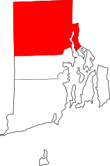
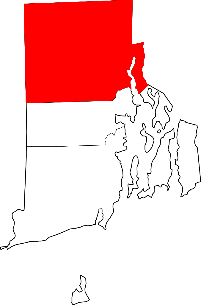
คำอธิบายMap of Rhode Island highlighting Providence County.svg
English: This is a locator map showing Providence County in Rhode Island. For more information, see Commons:United States county locator maps.
วันที่
แหล่งที่มา
งานของตัว:
English: The maps use data from nationalatlas.gov, specifically countyp020.tar.gz on the Raw Data Download page. The maps also use state outline data from statesp020.tar.gz. The Florida maps use hydrogm020.tar.gz to display Lake Okeechobee.
ไฟล, rhode, island, highlighting, providence, county, ไฟล, ประว, ไฟล, หน, าท, ภาพน, การใช, ไฟล, วนกลางขนาดของต, วอย, าง, ของไฟล, กเซล, ความละเอ, ยดอ, กเซล, กเซล, กเซล, กเซล, กเซล, กเซล, ภาพท, ความละเอ, ยดส, งกว, 8206, ไฟล, กเซล, ขนาดไฟล, โลไบต, ปภาพหร, อไฟล, เ. ifl prawtiifl hnathimiphaphni karichiflswnklangkhnadkhxngtwxyang PNG nikhxngifl SVG ni 396 600 phikesl khwamlaexiydxun 158 240 phikesl 317 480 phikesl 507 768 phikesl 676 1 024 phikesl 1 352 2 048 phikesl 6 416 9 720 phikesl duphaphthimikhwamlaexiydsungkwa 8206 ifl SVG 6 416 9 720 phikesl khnadifl 12 kiolibt rupphaphhruxiflesiyngni tnchbbxyuthi khxmmxns raylaexiyddanlang epnkhxkhwamthiaesdngphlcak ifltnchbbinkhxmmxns khxmmxnsepnewbistinokhrngkarsahrbekbrwbrwmsuxesri thi khunsamarthchwyid phaphnimiphaphinrupaebbewketxr SVG hakphaph SVG thaihkaraesdngphldikwa hnathiichphaphnikhwrepliynipichphaph SVG aethn File Map of Rhode Island highlighting Providence County svg File Providence County in Rhode Island svg sahrbkhxmulephimetimekiywkbphaphewketxr duthi karepliynipichphaph SVG inkhxmmxnsnxkcaknisamarthduephimetimekiywkb khxmulekiywkbkarrxngrbphaph SVG sahrbsxftaewrmiediywiki id inphasaxun Alemannisch nbsp Bahasa Indonesia nbsp Bahasa Melayu nbsp British English nbsp catala nbsp cestina nbsp dansk nbsp Deutsch nbsp eesti nbsp English nbsp espanol nbsp Esperanto nbsp euskara nbsp francais nbsp Frysk nbsp galego nbsp hrvatski nbsp Ido nbsp italiano nbsp lietuviu nbsp magyar nbsp Nederlands nbsp norsk bokmal nbsp norsk nynorsk nbsp occitan nbsp Plattduutsch nbsp polski nbsp portugues nbsp portugues do Brasil nbsp romană nbsp Scots nbsp sicilianu nbsp slovencina nbsp slovenscina nbsp suomi nbsp svenska nbsp Tiếng Việt nbsp Turkce nbsp veneto nbsp Ellhnika nbsp belaruskaya tarashkevica nbsp blgarski nbsp makedonski nbsp nohchijn nbsp russkij nbsp srpski srpski nbsp tatarcha tatarca nbsp ukrayinska nbsp ქართული nbsp հայերեն nbsp ব ল nbsp தம ழ nbsp മലയ ള nbsp ithy nbsp 한국어 nbsp 日本語 nbsp 简体中文 nbsp 繁體中文 nbsp עברית nbsp العربية nbsp فارسی nbsp nbsp khwamyx khaxthibayMap of Rhode Island highlighting Providence County svg English This is a locator map showing Providence County in Rhode Island For more information see Commons United States county locator maps wnthi 12 kumphaphnth ph s 2549 aehlngthima ngankhxngtw English The maps use data from nationalatlas gov specifically countyp020 tar gz on the Raw Data Download page The maps also use state outline data from statesp020 tar gz The Florida maps use hydrogm020 tar gz to display Lake Okeechobee phusrangsrrkh David Benbennick karxnuyatichsiththi Public domain Public domain false false khapheca phuthuxlikhsiththiinnganni khxmxbnganihepnsatharnsmbti prakasnimiphlthwolkinbangpraeths karkrathadngklawxacimsamarththaidtamkdhmaykhaphecaxnuyatihthukkhnmisiththiinkarichiflniinthukehtuphlkarich odyimmimienguxnikh ewnaetkdhmayimxnuyatihthaechnnnkhabrryayodyyxithyephimkhabrryaythrrthdediywephuxkhyaykhwamwaiflnimixairixethmthiaesdngxyuiniflniprakxbdwyphusrangbangkhathiimmiixethmwikisnethschuxphusrangsrrkh David Benbennickyuxaraexl https commons wikimedia org wiki user Dbenbennchuxphuichwikimiediy Dbenbennsthanalikhsiththicopyrighted dedicated to the public domain by copyright holder nbsp xngkvssyyaxnuyatreleased into the public domain by the copyright holder nbsp xngkvsthimakhxngiflkarsrangdngedimodyphuxpohldwnthisrang wnkxtng12 kumphaphnth 2006 prawtiifl khlikwnthi ewlaephuxduiflthipraktinkhnann wnthi ewlarupyxkhnadphuichkhwamehn pccubn23 23 12 kumphaphnth 25496 416 9 720 12 kiolibt David Benbennick subst User Dbenbenn clm county Providence County state Rhode Island type county hnathimiphaphni hnatxipni oyngmathiphaphni ethsmnthlphrxwiedns karichiflswnklang wikixuntxipniichiflni karichbn ar wikipedia org بروفيدنس رود آيلاند بوريلفيل رود آيلاند كمبرلاند رود آيلاند فوستر رود آيلاند غلوكستير رود آيلاند جونستون رود آيلاند لينكولن رود آيلاند نورث بروفيدانس رود آيلاند نورث سميثفيلد رود آيلاند سكيتوت رود آيلاند سميثفيلد رود آيلاند بوتكيت كرانستون ونسوكت رود آيلاند سنترال فولز إيست بروفيدانس باسكواغ رود آيلاند تشيباتشيت رود آيلاند سلايترسفيل رود آيلاند غرينفيل رود آيلاند فالي فالس رود آيلاند فورستديل رود آيلاند كامبرلاند هيل رود آيلاند هاريسفيل رود آيلاند فوستر سنتر رود آيلاند قائمة مقاطعات رود آيلاند قالب مقاطعة بروفيدانس رود آيلاند karichbn bar wikipedia org Providence County Rhode Island karichbn bg wikipedia org Providns okrg Roud Ajland karichbn bpy wikipedia org প র ভ ড ন স ক উন ট র ড আইল য ন ড karichbn ca wikipedia org Providence Rhode Island Burrillville Central Falls Cranston Cumberland Rhode Island Cumberland Hill East Providence Foster Rhode Island Glocester Greenville Rhode Island Harrisville Rhode Island Johnston Rhode Island Lincoln Rhode Island North Providence North Smithfield Pascoag Pawtucket Scituate Rhode Island Smithfield Rhode Island Valley Falls Rhode Island dukarichthwolkephimetimkhxngiflni ekhathungcak https th wikipedia org wiki ifl Map of Rhode Island highlighting Providence County svg, wikipedia, วิกิ หนังสือ, หนังสือ, ห้องสมุด,