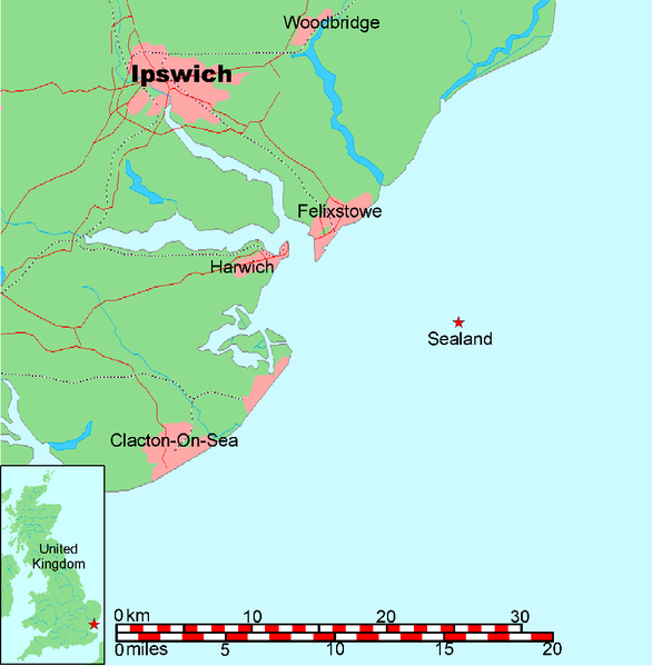
This is a map of the coast of England near Ipswich, showing the location of Sealand. See also Image:Map of Sealand with territorial waters.png for a map including the boundaries of the territorial waters of the United Kingdom.
A vector graphic file for the map without the territorial waters can be found at Image:Map of Sealand with territorial waters.svg
A PNG graphic file for the map without the territorial waters can be found at Image:Map of Sealand with territorial waters.png
The OpenOffice.org source file can be found at Image:Map of Sealand with territorial waters.sxd
Map generated by DEMIS World Map Server and edited by Chris 73
Licensing:
This image was created by Chris 73. The image is licensed under a dual license; please choose either of the two licenses below as desired. Attribution to Wikipedia or another project of the Wikimedia foundation is required for both licenses if the image is used outside of projects of the Wikimedia foundation. Attribution to me is not required.
You can use this image freely for any purpose, including commercial use, provided that you license it under one of the above licenses. My suggestion is to use the following text:
This Wikipedia and Wikimedia Commons image is from the user Chris 73 and is freely available at //commons.wikimedia.org/wiki/File:Map_of_Sealand.png under the creative commons cc-by-sa 3.0 license.
For privacy reasons please use only "Chris 73" as author. If necessary, please translate the text in your language. For electronic use please include the links in the text as shown, for printed use please print the text as shown. If you use the image I would appreciate it if you would let me know on my talk page, but this is not required as long as you follow one of the above licenses.
Користувач:Alex Blokha/Події в Вікіпедії/23 червня
Користувач:Alex Blokha/Події в Вікіпедії/10 січня
มกราคม 20, 2023
ไฟล, sealand, ไฟล, ประว, ไฟล, หน, าท, ภาพน, การใช, ไฟล, วนกลางขนาดของต, วอย, างน, กเซล, ความละเอ, ยดอ, กเซล, กเซล, กเซล, กเซล, ภาพท, ความละเอ, ยดส, งกว, 8206, กเซล, ขนาดไฟล, โลไบต, ชน, ดไมม, image, ปภาพหร, อไฟล, เส, ยงน, นฉบ, บอย, คอมมอนส, รายละเอ, ยดด, านล, า. ifl prawtiifl hnathimiphaphni karichiflswnklangkhnadkhxngtwxyangni 586 599 phikesl khwamlaexiydxun 235 240 phikesl 469 480 phikesl 751 768 phikesl 1 024 1 047 phikesl duphaphthimikhwamlaexiydsungkwa 8206 1 024 1 047 phikesl khnadifl 36 kiolibt chnidimm image png rupphaphhruxiflesiyngni tnchbbxyuthi khxmmxns raylaexiyddanlang epnkhxkhwamthiaesdngphlcak ifltnchbbinkhxmmxns khxmmxnsepnewbistinokhrngkarsahrbekbrwbrwmsuxesri thi khunsamarthchwyid Map of SealandThis is a map of the coast of England near Ipswich showing the location of Sealand See also Image Map of Sealand with territorial waters png for a map including the boundaries of the territorial waters of the United Kingdom A vector graphic file for the map without the territorial waters can be found at Image Map of Sealand with territorial waters svg A PNG graphic file for the map without the territorial waters can be found at Image Map of Sealand with territorial waters png The OpenOffice org source file can be found at Image Map of Sealand with territorial waters sxdMap generated by DEMIS World Map Server and edited by Chris 73 Licensing This image was created by Chris 73 The image is licensed under a dual license please choose either of the two licenses below as desired Attribution to Wikipedia or another project of the Wikimedia foundation is required for both licenses if the image is used outside of projects of the Wikimedia foundation Attribution to me is not required xnuyatihkhdlxk aeckcayaela hruxddaeprexksarniphayitenguxnikhkhxngsyyaxnuyatexksaresrikhxngknu run 1 3 hruxrunid nbcaknithixxkodymulnithisxftaewresri odyimmiswnidhamaekikh immikhxkhwampkhnaaelapkhlng saenakhxngsyyaxnuyatrwmxyuinswnchux syyaxnuyatexksaresrikhxngknu www gnu org licenses fdl 1 3 html GFDL 1 3 GNU Free Documentation License 1 3 true trueiflnixyuphayitsyyaxnuyat khriexthifkhxmmxns aebbaesdngthima xnuyataebbediywkn 3 0 tnchbbkaraesdngthima Chris 73 Wikimedia Commonskhunsamarth thicaaebngpn thicathasaena aeckcay aelasngngandngklawtxip thicaeriyberiyngihm thicaddaeplngngandngklaw phayitenguxnikhtxipni aesdngthima khuntxngihekiyrtiecakhxngnganxyangehmaasm odyephimlingkipyngsyyaxnuyat aelarabuhakmikarepliynaeplng khunxacthaechnniidinrupaebbidkidtamkhwr aettxngimichinlksnathiaenawaphuihxnuyatsnbsnunkhunhruxkarichngankhxngkhun xnuyataebbediywkn hakkhunddaeplng epliynrup hruxtxetimnganni khuntxngichsyyaxnuyataebbediywknhruxaebbthiehmuxnkbsyyaxnuyatthiichkbnganniethannhttps creativecommons org licenses by sa 3 0 CC BY SA 3 0 Creative Commons Attribution Share Alike 3 0 true true I want to use the image How do I do that You can use this image freely for any purpose including commercial use provided that you license it under one of the above licenses My suggestion is to use the following text This Wikipedia and Wikimedia Commons image is from the user Chris 73 and is freely available at commons wikimedia org wiki File Map of Sealand png under the creative commons cc by sa 3 0 license For privacy reasons please use only Chris 73 as author If necessary please translate the text in your language For electronic use please include the links in the text as shown for printed use please print the text as shown If you use the image I would appreciate it if you would let me know on my talk page but this is not required as long as you follow one of the above licenses 中文 Image Map of Sealand zh pngkhabrryayodyyxithyephimkhabrryaythrrthdediywephuxkhyaykhwamwaiflnimixairixethmthiaesdngxyuiniflniprakxbdwysthanalikhsiththimilikhsiththisyyaxnuyatCreative Commons Attribution ShareAlike 3 0 Unported xngkvsGNU Free Documentation License version 1 3 or later xngkvs prawtiifl khlikwnthi ewlaephuxduiflthipraktinkhnann wnthi ewlarupyxkhnadphuichkhwamehn pccubn17 00 26 mkrakhm 25481 024 1 047 36 kiolibt Chris 73 16 28 26 mkrakhm 25481 024 1 048 36 kiolibt Chris 73changed scale and also stretched a bit 12 24 26 mkrakhm 2548998 733 32 kiolibt Chris 73Map of Sealand hnathimiphaphni immihnaidoyngmathiphaphnikarichiflswnklang wikixuntxipniichiflni karichbn be tarask wikipedia org Silend karichbn bg wikipedia org Sijland karichbn ca wikipedia org Sealand karichbn cy wikipedia org Tywysogaeth Sealand karichbn da wikipedia org Sealand Bruger Mathiashamzamirza Sealand Skabelon Infoboks land testcases karichbn et wikipedia org Sealand karichbn is wikipedia org Sealand karichbn it wikipedia org Utente Mikialba Sandbox3 karichbn lv wikipedia org Silenda karichbn ms wikipedia org Sealand karichbn nn wikipedia org Sealand karichbn no wikipedia org Sealand karichbn scn wikipedia org Principatu di Selanda karichbn sv wikipedia org Sealand karichbn uk wikipedia org Silandiya Koristuvach Alex Blokha Podiyi v Vikipediyi 23 chervnya Koristuvach Alex Blokha Podiyi v Vikipediyi 10 sichnya karichbn www wikidata org Q13706 ekhathungcak https th wikipedia org wiki ifl Map of Sealand png, wikipedia, วิกิ หนังสือ, หนังสือ, ห้องสมุด,