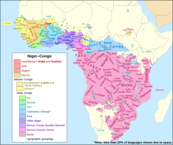
ไฟล, niger, congo, languages, ไฟล, ประว, ไฟล, หน, าท, ภาพน, การใช, ไฟล, วนกลาง, อม, ลเก, ยวก, บภาพขนาดของต, วอย, าง, ของไฟล, กเซล, ความละเอ, ยดอ, กเซล, กเซล, กเซล, กเซล, กเซล, กเซล, ภาพท, ความละเอ, ยดส, งกว, 8206, ไฟล, กเซล, ขนาดไฟล, เมกะไบต, ปภาพหร, อไฟล, เส,. ifl prawtiifl hnathimiphaphni karichiflswnklang khxmulekiywkbphaphkhnadkhxngtwxyang PNG nikhxngifl SVG ni 717 600 phikesl khwamlaexiydxun 287 240 phikesl 574 480 phikesl 918 768 phikesl 1 224 1 024 phikesl 2 447 2 048 phikesl 1 342 1 123 phikesl duphaphthimikhwamlaexiydsungkwa 8206 ifl SVG 1 342 1 123 phikesl khnadifl 1 09 emkaibt rupphaphhruxiflesiyngni tnchbbxyuthi khxmmxns raylaexiyddanlang epnkhxkhwamthiaesdngphlcak ifltnchbbinkhxmmxns khxmmxnsepnewbistinokhrngkarsahrbekbrwbrwmsuxesri thi khunsamarthchwyid khwamyx khaxthibayMap of the Niger Congo languages svg English Clickable map of the Niger Congo language family its subfamilies and its major languages wnthi 10 krkdakhm ph s 2560 aehlngthima Created from File Africa map blank svg Based on design of File Map of the Niger Congo and Khoisan languages svg phusrangsrrkh File Africa map blank svg User Sting Derivative work User SUM1 Language info compiled from various Ethnologue country maps as also compiled in Muturzikin karxnuyatichsiththi iflnixyuphayitsyyaxnuyat khriexthifkhxmmxns aebbaesdngthima xnuyataebbediywkn 4 0 nanachatikhunsamarth thicaaebngpn thicathasaena aeckcay aelasngngandngklawtxip thicaeriyberiyngihm thicaddaeplngngandngklaw phayitenguxnikhtxipni aesdngthima khuntxngihekiyrtiecakhxngnganxyangehmaasm odyephimlingkipyngsyyaxnuyat aelarabuhakmikarepliynaeplng khunxacthaechnniidinrupaebbidkidtamkhwr aettxngimichinlksnathiaenawaphuihxnuyatsnbsnunkhunhruxkarichngankhxngkhun xnuyataebbediywkn hakkhunddaeplng epliynrup hruxtxetimnganni khuntxngichsyyaxnuyataebbediywknhruxaebbthiehmuxnkbsyyaxnuyatthiichkbnganniethannhttps creativecommons org licenses by sa 4 0 CC BY SA 4 0 Creative Commons Attribution Share Alike 4 0 true truekhabrryayodyyxithyephimkhabrryaythrrthdediywephuxkhyaykhwamwaiflnimixairxngkvsMap of the Niger Congo language familyixethmthiaesdngxyuiniflniprakxbdwysthanalikhsiththimilikhsiththisyyaxnuyatCreative Commons Attribution ShareAlike 4 0 International nbsp xngkvswnthisrang wnkxtng10 krkdakhm 2017MIME type nbsp xngkvsimage svg xml prawtiifl khlikwnthi ewlaephuxduiflthipraktinkhnann wnthi ewlarupyxkhnadphuichkhwamehn pccubn03 50 2 mithunayn 25611 342 1 123 1 09 emkaibt SUM1Added note and fixed key 22 16 18 krkdakhm 25601 342 1 123 1 09 emkaibt SUM1Fixed southern Bantu boundary 05 05 16 krkdakhm 25601 342 1 123 1 1 emkaibt SUM1Fixed Adamawa Ubangi boundary 03 55 13 krkdakhm 25601 342 1 123 1 06 emkaibt SUM1Added shading border 04 16 11 krkdakhm 25601 342 1 123 1 04 emkaibt SUM1Fixed extra Katla shading 04 12 11 krkdakhm 25601 342 1 123 1 04 emkaibt SUM1Fixed layer of Kordofanian shading 04 01 11 krkdakhm 25601 342 1 123 1 04 emkaibt SUM1Fixed Kordofanian classification 23 00 10 krkdakhm 25601 342 1 123 1 03 emkaibt SUM1Fixed Bantu and Adamawa Ubangi boundaries 07 59 10 krkdakhm 25601 342 1 123 1 03 emkaibt SUM1User created page with UploadWizard hnathimiphaphni hnatxipni oyngmathiphaphni trakulphasainecxr khxngok karichiflswnklang wikixuntxipniichiflni karichbn bcl wikipedia org Mga tataramon na Niger Congo karichbn ca wikipedia org Llengues nigerocongoleses karichbn de wikipedia org Afrikanische Religionen karichbn diq wikipedia org Ziwane Nicer Kongoy karichbn en wikipedia org Niger Congo languages User SUM1 Contributions Population history of West Africa karichbn en wikiversity org Draft Languages and language families karichbn fa wikipedia org زبان های نیجر کنگو karichbn fr wikipedia org Langues nigero congolaises karichbn gl wikipedia org Linguas mandes karichbn ha wikipedia org Harsunan Nijar Congo karichbn id wikipedia org Bahasa Ndut Templat NigerCongo lang stub karichbn ie wikipedia org Lingues niger congan karichbn lfn wikipedia org Linguas nijer congo karichbn lij wikipedia org Lengue niger kordofaniann e karichbn mzn wikipedia org نیجر کنگو زوونون karichbn ne wikipedia org न इजर कङ ग भ ष पर व र karichbn nqo wikipedia org ߖߋ ߟߌߓߊ ߣߌ ߞߏ ߜ ߏ ߟߎ ߝߍ ߞߊ ߠߎ karichbn ro wikipedia org Limbi nigero congoleze karichbn ru wikipedia org Nigero kongolezskie yazyki karichbn sat wikipedia org ᱢᱩᱬᱩᱛ ᱱᱟᱭᱡᱟᱨᱼᱠᱚᱝᱜᱳ ᱯᱟᱹᱨᱥᱤᱠᱚ karichbn sl wikipedia org Seznam jezikovnih druzin in jezikov karichbn sn wikipedia org Mitauro ye Chinaija Kongo karichbn tr wikipedia org Nijer Kongo dilleri karichbn ur wikipedia org نائجر کانگو زبانیں karichbn uz wikipedia org Niger kongo tillari karichbn www wikidata org Q33838khxmulekiywkbphaph phaphnimikhxmulephimetim sungswnihymacakklxngdicitxlhruxsaeknenxrthisamarthekbkhxmuldngklawiwrwmkbphaphid thaphaphnithukprbprungaekikhhruxepliynaeplngcakedim khxmulbangxyangcayngkhngimepliynaeplngehmuxnphaphthithukprbprungaekikhnnchuxeruxngsnBlank map of the African continentkhwamkwang1341 8438khwamsung1122 6584 ekhathungcak https th wikipedia org wiki ifl Map of the Niger Congo languages svg, wikipedia, วิกิ หนังสือ, หนังสือ, ห้องสมุด,