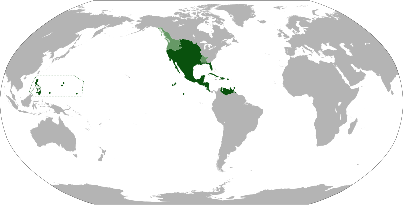
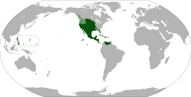
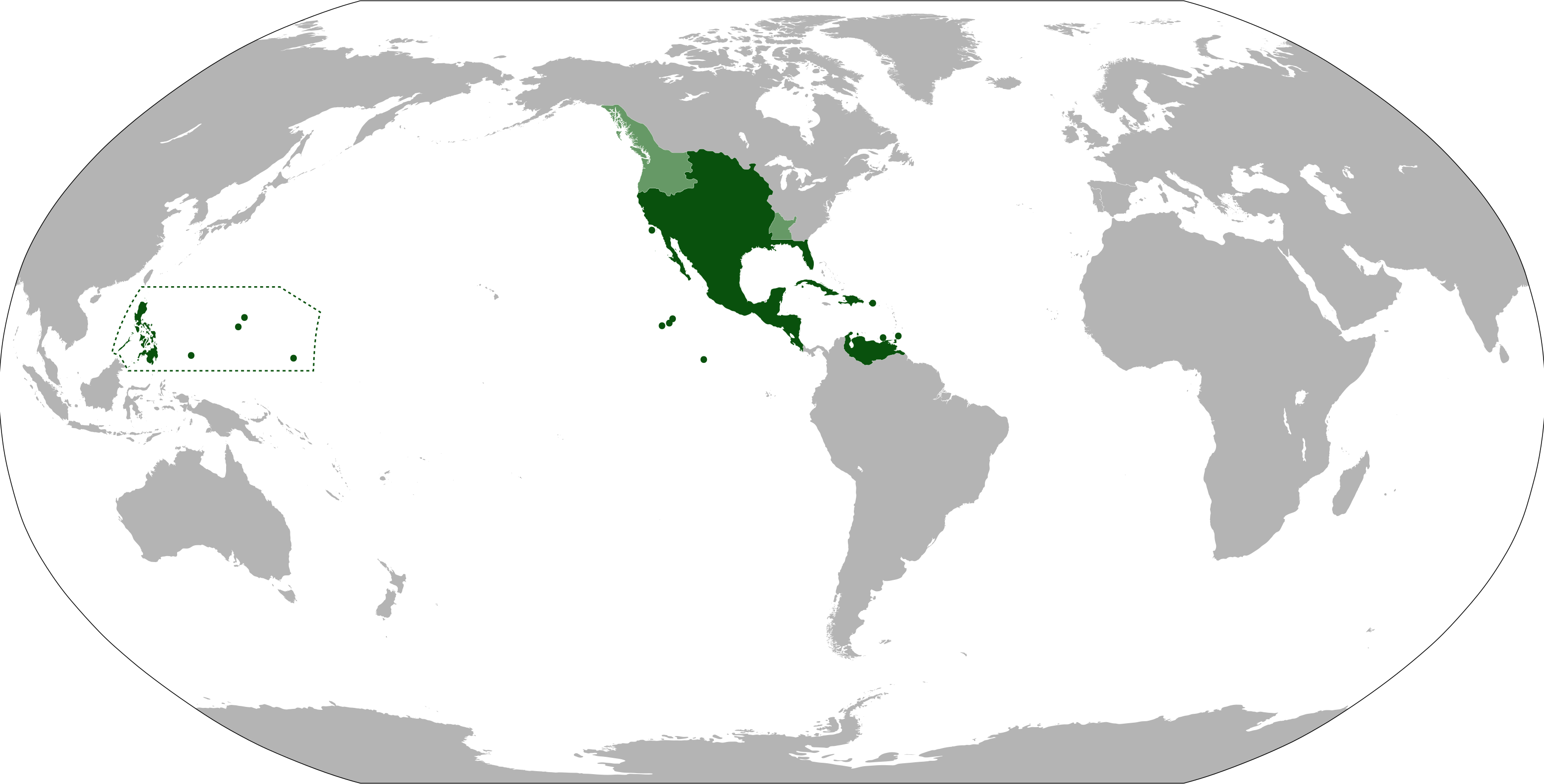
English: Anachronistic map of New Spain, built from Image:New_Spain.png by myself and released on multi-licence (GFDL and CC-BY 2.5). This image includes the territory of Louisiana, annexed to the Spanish Empire in 1763 after the Seven Years' War, but then given back to France in 1801. The areas in light green were territories claimed by Spain.
{{Information |Description={{en|1=Anachronistic map of New Spain, built from w:Image:New_Spain.png by myself and released on multi-licence (GFDL and CC-BY 2.5). This image includes the territory of Louisiana, annexed to the Spanish Empire in 1763 after th
ไฟล, viceroyalty, spain, ไฟล, ประว, ไฟล, หน, าท, ภาพน, การใช, ไฟล, วนกลาง, อม, ลเก, ยวก, บภาพขนาดของต, วอย, าง, ของไฟล, กเซล, ความละเอ, ยดอ, กเซล, กเซล, กเซล, กเซล, กเซล, กเซล, ภาพท, ความละเอ, ยดส, งกว, 8206, ไฟล, กเซล, ขนาดไฟล, เมกะไบต, ปภาพหร, อไฟล, เส, ยงน,. ifl prawtiifl hnathimiphaphni karichiflswnklang khxmulekiywkbphaphkhnadkhxngtwxyang PNG nikhxngifl SVG ni 800 407 phikesl khwamlaexiydxun 320 163 phikesl 640 325 phikesl 1 024 520 phikesl 1 280 650 phikesl 2 560 1 301 phikesl 3 121 1 586 phikesl duphaphthimikhwamlaexiydsungkwa 8206 ifl SVG 3 121 1 586 phikesl khnadifl 1 67 emkaibt rupphaphhruxiflesiyngni tnchbbxyuthi khxmmxns raylaexiyddanlang epnkhxkhwamthiaesdngphlcak ifltnchbbinkhxmmxns khxmmxnsepnewbistinokhrngkarsahrbekbrwbrwmsuxesri thi khunsamarthchwyid khwamyx khaxthibayMap of the Viceroyalty of New Spain svg English Anachronistic map of New Spain built from Image New Spain png by myself and released on multi licence GFDL and CC BY 2 5 This image includes the territory of Louisiana annexed to the Spanish Empire in 1763 after the Seven Years War but then given back to France in 1801 The areas in light green were territories claimed by Spain wnthi 10 knyayn ph s 2553aehlngthima ngankhxngtw File BlankMap World 90W svg File New Spain png File Nueva Espana 1795 png File Spanish Provinces in the Pacific pngphusrangsrrkh Eddo karxnuyatichsiththi khapheca inthanaphuthuxlikhsiththikhxngphaphhruxsuxni xnuyatihichphaphhruxsuxniphayitenguxnikhtxipniiflnixyuphayitsyyaxnuyat khriexthifkhxmmxns aebbaesdngthima xnuyataebbediywkn 3 0 tnchbbkhunsamarth thicaaebngpn thicathasaena aeckcay aelasngngandngklawtxip thicaeriyberiyngihm thicaddaeplngngandngklaw phayitenguxnikhtxipni aesdngthima khuntxngihekiyrtiecakhxngnganxyangehmaasm odyephimlingkipyngsyyaxnuyat aelarabuhakmikarepliynaeplng khunxacthaechnniidinrupaebbidkidtamkhwr aettxngimichinlksnathiaenawaphuihxnuyatsnbsnunkhunhruxkarichngankhxngkhun xnuyataebbediywkn hakkhunddaeplng epliynrup hruxtxetimnganni khuntxngichsyyaxnuyataebbediywknhruxaebbthiehmuxnkbsyyaxnuyatthiichkbnganniethannhttps creativecommons org licenses by sa 3 0 CC BY SA 3 0 Creative Commons Attribution Share Alike 3 0 true true xnuyatihkhdlxk aeckcayaela hruxddaeprexksarniphayitenguxnikhkhxngsyyaxnuyatexksaresrikhxngknu run 1 2 hruxrunid nbcaknithixxkodymulnithisxftaewresri odyimmiswnidhamaekikh immikhxkhwampkhnaaelapkhlng saenakhxngsyyaxnuyatrwmxyuinswnchux syyaxnuyatexksaresrikhxngknuhttp www gnu org copyleft fdl html GFDL GNU Free Documentation License true truekhunsamartheluxksyyaxnuyatdngklawtamtxngkarkhabrryayodyyxithyephimkhabrryaythrrthdediywephuxkhyaykhwamwaiflnimixairxngkvsAnachronistic map of New Spain areas in light green are territories that were claimed by Spain eyxrmnVizekonigreich Neuspanien spanisch Virreinato de Nueva Espana 1535 1821 Abb 1763 ixethmthiaesdngxyuiniflniprakxbdwyekhtxuprachaehngniwsepnphusrangbangkhathiimmiixethmwikisnethschuxphuichwikimiediy Eddochuxphusrangsrrkh Eddoyuxaraexl https commons wikimedia org wiki user EddosthanalikhsiththimilikhsiththisyyaxnuyatGNU Free Documentation License version 1 2 or later xngkvsCreative Commons Attribution ShareAlike 3 0 Unported xngkvsthimakhxngiflkarsrangdngedimodyphuxpohldwnthisrang wnkxtng10 knyayn 2010MIME type xngkvsimage svg xml prawtiifl khlikwnthi ewlaephuxduiflthipraktinkhnann wnthi ewlarupyxkhnadphuichkhwamehn pccubn18 09 15 knyayn 25553 121 1 586 1 67 emkaibt Milenioscurocambio la proyeccion corrijo las fronteras de la Luisiana espanola anado linderos de la capitania general de las Filipinas 14 26 6 singhakhm 2555853 433 1 5 emkaibt UnukalhaiLa Capitania General de Venezuela estuvo bajo jurisdiccion de la Real Audiencia de Santo Domingo y esta a su vez del Virreinato de Nueva Espana 07 48 13 mithunayn 2554853 433 1 49 emkaibt DureroMore islands the Caroline the Marianas Palau 14 21 10 knyayn 2553853 433 1 49 emkaibt Eddo Information Description en 1 Anachronistic map of New Spain built from w Image New Spain png by myself and released on multi licence GFDL and CC BY 2 5 This image includes the territory of Louisiana annexed to the Spanish Empire in 1763 after th hnathimiphaphni hnatxipni oyngmathiphaphni niwsepn karichiflswnklang wikixuntxipniichiflni karichbn af wikipedia org Nieu Spanje karichbn ar wikipedia org إسبانيا الجديدة karichbn ast wikipedia org Imperiu espanol n Asia y Oceania Virreinatu de Nueva Espana karichbn azb wikipedia org یئنی ایسپانیا karichbn bar wikipedia org Mexiko karichbn ba wikipedia org Amerika tarihy karichbn bg wikipedia org Nova Ispaniya karichbn br wikipedia org Spagn Nevez karichbn ca wikipedia org Virregnat de Nova Espanya Portal Historia Articles seleccionats Plantilla Article d historia de la setmana 35 karichbn cs wikipedia org Spanelska Vychodni Indie Mistokralovstvi Nove Spanelsko karichbn da wikipedia org Nyspanien karichbn de wikipedia org Vizekonigreich Neuspanien Mexiko Dragones de Cuera karichbn el wikipedia org Nea Ispania karichbn en wikipedia org New Spain Ciudad Victoria Mexico Talk Ming dynasty Archive 2 karichbn eo wikipedia org Vicreĝlando Nova Hispanio karichbn es wikipedia org Imperio espanol Discusion Real y Pontificia Universidad de Mexico Consolidacion de Nueva Espana Religion en Nueva Espana Historia territorial del Estado de Mexico Virreinato de Nueva Espana Wikipedia Cafe Archivo 2016 Mayo Wikipedia Cafe Portal Archivo Miscelanea 2016 05 karichbn et wikipedia org Uus Hispaania asekuningriik karichbn eu wikipedia org Espainia Berriko Erregeorderria karichbn fa wikipedia org اسپانیای نو karichbn fi wikipedia org Uusi Espanja karichbn fr wikipedia org Nouvelle Espagne Colonisation espagnole de l Amerique karichbn gl wikipedia org Imperio Espanol Vicerreinado de Nova Espana karichbn he wikipedia org מלכות המשנה של ספרד החדשה karichbn hu wikipedia org Uj Spanyolorszag karichbn hy wikipedia org Մեքսիկայի պատմություն Նոր Իսպանիայի փոխարքայություն Մասնակից SonaMur97 Ավազարկղ karichbn ia wikipedia org Vice regno Nove Espania karichbn id wikipedia org Spanyol Baru karichbn is wikipedia org Mexiko Nyi Spann karichbn it wikipedia org Vicereame della Nuova Spagna dukarichthwolkephimetimkhxngiflnikhxmulekiywkbphaph phaphnimikhxmulephimetim sungswnihymacakklxngdicitxlhruxsaeknenxrthisamarthekbkhxmuldngklawiwrwmkbphaphid thaphaphnithukprbprungaekikhhruxepliynaeplngcakedim khxmulbangxyangcayngkhngimepliynaeplngehmuxnphaphthithukprbprungaekikhnnkhwamkwang3121 47khwamsung1585 71 ekhathungcak https th wikipedia org wiki ifl Map of the Viceroyalty of New Spain svg, wikipedia, วิกิ หนังสือ, หนังสือ, ห้องสมุด,