คำอธิบายMap of the provinces of South Africa 1910-1976 with English labels.svg
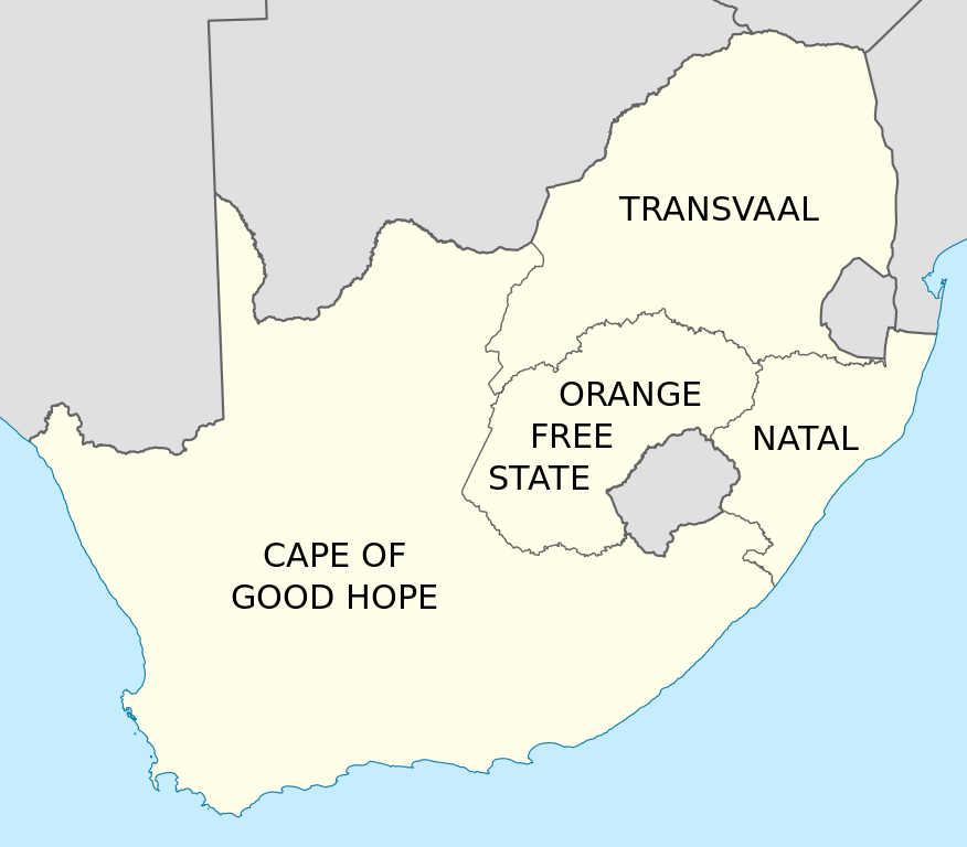
English: Map of South Africa showing the provinces as they were from 1910 to 1976, with labels in English. Based on File:Map of South Africa with provincial borders 1910-1976.svg.
วันที่
แหล่งที่มา
งานของตัว
ผู้สร้างสรรค์
Htonl
เวอร์ชันอื่น
File:Map of South Africa with provincial borders 1910-1976.svg, File:Kaart van die provinsies van Suid-Afrika 1910-1976 met Afrikaanse byskrifte.svg
List of administrators of former South African provinces
1909年南非法令
Talk:1909年南非法令
มกราคม 22, 2023
ไฟล, provinces, south, africa, 1910, 1976, with, english, labels, ไฟล, ประว, ไฟล, หน, าท, ภาพน, การใช, ไฟล, วนกลางขนาดของต, วอย, าง, ของไฟล, กเซล, ความละเอ, ยดอ, กเซล, กเซล, กเซล, กเซล, กเซล, กเซล, ภาพท, ความละเอ, ยดส, งกว, 8206, ไฟล, กเซล, ขนาดไฟล, โลไบต, ปภา. ifl prawtiifl hnathimiphaphni karichiflswnklangkhnadkhxngtwxyang PNG nikhxngifl SVG ni 684 599 phikesl khwamlaexiydxun 274 240 phikesl 548 480 phikesl 876 768 phikesl 1 168 1 024 phikesl 2 337 2 048 phikesl 809 709 phikesl duphaphthimikhwamlaexiydsungkwa 8206 ifl SVG 809 709 phikesl khnadifl 393 kiolibt rupphaphhruxiflesiyngni tnchbbxyuthi khxmmxns raylaexiyddanlang epnkhxkhwamthiaesdngphlcak ifltnchbbinkhxmmxns khxmmxnsepnewbistinokhrngkarsahrbekbrwbrwmsuxesri thi khunsamarthchwyid khwamyx khaxthibayMap of the provinces of South Africa 1910 1976 with English labels svg English Map of South Africa showing the provinces as they were from 1910 to 1976 with labels in English Based on File Map of South Africa with provincial borders 1910 1976 svg wnthi 7 minakhm ph s 2554aehlngthima ngankhxngtwphusrangsrrkh Htonlewxrchnxun File Map of South Africa with provincial borders 1910 1976 svg File Kaart van die provinsies van Suid Afrika 1910 1976 met Afrikaanse byskrifte svg karxnuyatichsiththi khapheca inthanaphuthuxlikhsiththikhxngphaphhruxsuxni xnuyatihichphaphhruxsuxniphayitenguxnikhtxipniiflnixyuphayitsyyaxnuyat khriexthifkhxmmxns aebbaesdngthima xnuyataebbediywkn 3 0 tnchbbkhunsamarth thicaaebngpn thicathasaena aeckcay aelasngngandngklawtxip thicaeriyberiyngihm thicaddaeplngngandngklaw phayitenguxnikhtxipni aesdngthima khuntxngihekiyrtiecakhxngnganxyangehmaasm odyephimlingkipyngsyyaxnuyat aelarabuhakmikarepliynaeplng khunxacthaechnniidinrupaebbidkidtamkhwr aettxngimichinlksnathiaenawaphuihxnuyatsnbsnunkhunhruxkarichngankhxngkhun xnuyataebbediywkn hakkhunddaeplng epliynrup hruxtxetimnganni khuntxngichsyyaxnuyataebbediywknhruxaebbthiehmuxnkbsyyaxnuyatthiichkbnganniethannhttps creativecommons org licenses by sa 3 0 CC BY SA 3 0 Creative Commons Attribution Share Alike 3 0 true true xnuyatihkhdlxk aeckcayaela hruxddaeprexksarniphayitenguxnikhkhxngsyyaxnuyatexksaresrikhxngknu run 1 2 hruxrunid nbcaknithixxkodymulnithisxftaewresri odyimmiswnidhamaekikh immikhxkhwampkhnaaelapkhlng saenakhxngsyyaxnuyatrwmxyuinswnchux syyaxnuyatexksaresrikhxngknuhttp www gnu org copyleft fdl html GFDL GNU Free Documentation License true truekhunsamartheluxksyyaxnuyatdngklawtamtxngkarkhabrryayodyyxithyephimkhabrryaythrrthdediywephuxkhyaykhwamwaiflnimixairixethmthiaesdngxyuiniflniprakxbdwyphusrangbangkhathiimmiixethmwikisnethschuxphuichwikimiediy Htonlchuxphusrangsrrkh Htonlyuxaraexl https commons wikimedia org wiki user HtonlsthanalikhsiththimilikhsiththisyyaxnuyatGNU Free Documentation License version 1 2 or later xngkvsCreative Commons Attribution ShareAlike 3 0 Unported xngkvsthimakhxngiflkarsrangdngedimodyphuxpohldwnthisrang wnkxtng7 minakhm 2011 prawtiifl khlikwnthi ewlaephuxduiflthipraktinkhnann wnthi ewlarupyxkhnadphuichkhwamehn pccubn04 55 8 minakhm 2554809 709 393 kiolibt Htonl Summary Information Description en 1 Map of South Africa showing the provinces as they were from 1910 to 1976 with labels in English Based on File Map of South Africa with provincial borders 1910 1976 svg Source own hnathimiphaphni hnatxipni oyngmathiphaphni cnghwdkhxngpraethsaexfrikait karichiflswnklang wikixuntxipniichiflni karichbn af wikipedia org Lys van administrateurs van voormalige Suid Afrikaanse provinsies karichbn ar wikipedia org مقاطعات جنوب أفريقيا karichbn ast wikipedia org Provincies de Sudafrica karichbn azb wikipedia org گونئی آفریقا بیرلیگی karichbn ca wikipedia org Provincies de Sud africa karichbn de wikipedia org Sudafrikanische Union karichbn en wikipedia org Union of South Africa Provinces of South Africa South Africa Act 1909 List of administrators of former South African provinces karichbn es wikipedia org Provincias de Sudafrica karichbn id wikipedia org Provinsi di Afrika Selatan karichbn it wikipedia org Unione Sudafricana karichbn ml wikipedia org ദക ഷ ണ ഫ ര ക കയ ല പ രവ ശ യകൾ karichbn ms wikipedia org Wilayah Afrika Selatan karichbn pl wikipedia org Zwiazek Poludniowej Afryki karichbn ro wikipedia org Uniunea Africii de Sud karichbn sl wikipedia org Juznoafriska unija karichbn tn wikipedia org Diprofense tsa Aforika Borwa karichbn tr wikipedia org Guney Afrika Birligi karichbn zh wikipedia org 南非聯邦 1909年南非法令 Talk 1909年南非法令 ekhathungcak https th wikipedia org wiki ifl Map of the provinces of South Africa 1910 1976 with English labels svg, wikipedia, วิกิ หนังสือ, หนังสือ, ห้องสมุด,