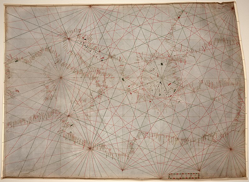
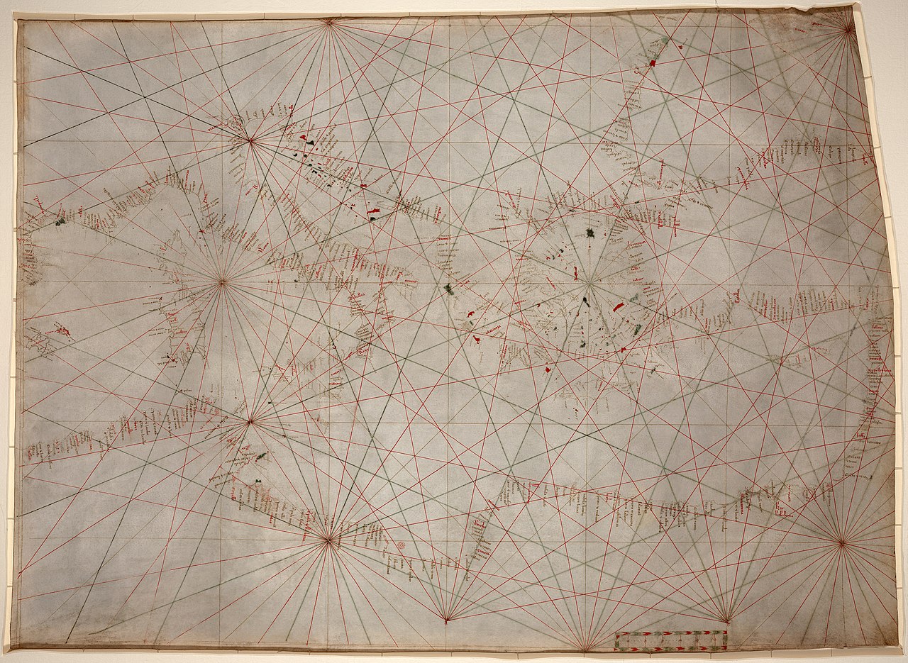
Anonymous nautical chart in portolan style probably drawn in Genoa.
Covers Mediterranean Sea from the Balearic Islands to the Levantine coast; also covers western part of Black Sea.
Oldest original cartographic artifact in the Library of Congress.
Title from printed label on box in which the map is housed.
Pen-and-ink (red/green/brown).
Matted and mounted between sheets of transparent lucite.
Sheet cut into the shape of an irregular rectangle.
Imperfect: Vertically fold-lined at center, cracked, annotated in pencil on verso. Includes bar scale with unidentified divisions. The green rhumb lines on the recto are also visible on the verso. Scale [ca. 1:5,500,000].
วันที่
circa 2404 หรือ 2405 หรือ 1863 - circa 2434 หรือ 2435 หรือ 1893
date QS:P,+1350-00-00T00:00:00Z/7,P1319,+1320-00-00T00:00:00Z/9,P1326,+1350-00-00T00:00:00Z/9,P1480,Q5727902
{{Information |Description=Anonymous nautical chart in portolan style probably drawn in Genoa. Covers Mediterranean Sea from the Balearic Islands to the Levantine coast; also covers western part of Black Sea. Oldest original cartographic artifact in t
ไฟล, mediterranean, chart, fourteenth, century2, ไฟล, ประว, ไฟล, หน, าท, ภาพน, การใช, ไฟล, วนกลาง, อม, ลเก, ยวก, บภาพขนาดของต, วอย, างน, กเซล, ความละเอ, ยดอ, กเซล, กเซล, กเซล, กเซล, กเซล, กเซล, ภาพท, ความละเอ, ยดส, งกว, 8206, กเซล, ขนาดไฟล, เมกะไบต, ชน, ดไมม, . ifl prawtiifl hnathimiphaphni karichiflswnklang khxmulekiywkbphaphkhnadkhxngtwxyangni 800 585 phikesl khwamlaexiydxun 320 234 phikesl 640 468 phikesl 1 024 748 phikesl 1 280 935 phikesl 2 560 1 871 phikesl 5 486 4 009 phikesl duphaphthimikhwamlaexiydsungkwa 8206 5 486 4 009 phikesl khnadifl 17 24 emkaibt chnidimm image jpeg rupphaphhruxiflesiyngni tnchbbxyuthi khxmmxns raylaexiyddanlang epnkhxkhwamthiaesdngphlcak ifltnchbbinkhxmmxns khxmmxnsepnewbistinokhrngkarsahrbekbrwbrwmsuxesri thi khunsamarthchwyid dwy xtraswn 4 3 hrux 5 4 phaphnicungehmaasmthicaichin phaphphunhlngkhxngkhxmphiwetxr du phaphthnghmd nikhuxphaphkhdsrrinwikiphiediyphasaxngkvs Featured pictures aela khux thuxwaepn phaphxyangidxyanghnungthidithisud nikhuxphaphkhdsrrinwikiphiediyphasaturki Seckin resimler aela khux thuxwaepn phaphxyangidxyanghnungthidithisudthakhidwaiflnikhwrcaihkhwamsakhykbwikimiediykhxmmxnsepnxyangdi xyalngelthica esnxchux hakkhunmiphaphthimikhunphaph khlaykhlungkn thicasamarthephyaephridtam syyaxnuyatthiehmaasm ihaenicwa khunid xpohld kahndsyyaxnuyat aelaid esnxchuxaelw phaphni idrbkarprbaetngphaph sunghmaykhwamwacaidrbkarepliynaeplngphaphtangcaktnchbb karprbprung stains dirt and creases removed some lines reconstructed selective brightness changes histogram adjusted and colors balanced tnchbbsamarthduidthini Mediterranean chart fourteenth century jpg prbaetngphaphody Durova khwamyx khaxthibayMediterranean chart fourteenth century2 jpg Anonymous nautical chart in portolan style probably drawn in Genoa Covers Mediterranean Sea from the Balearic Islands to the Levantine coast also covers western part of Black Sea Oldest original cartographic artifact in the Library of Congress Title from printed label on box in which the map is housed Pen and ink red green brown Matted and mounted between sheets of transparent lucite Sheet cut into the shape of an irregular rectangle Imperfect Vertically fold lined at center cracked annotated in pencil on verso Includes bar scale with unidentified divisions The green rhumb lines on the recto are also visible on the verso Scale ca 1 5 500 000 wnthi circa 2404 hrux 2405 hrux 1863 circa 2434 hrux 2435 hrux 1893 date QS P 1350 00 00T00 00 00Z 7 P1319 1320 00 00T00 00 00Z 9 P1326 1350 00 00T00 00 00Z 9 P1480 Q5727902aehlngthima Library of Congress 1 phusrangsrrkh anonymous probably Genoankarxnuyat karichiflniihm Public domain Public domain false falsenganniepnsatharnsmbti inpraethstnkaenidaelapraethsxun thirayaewlakarkhumkhrxnglikhsiththinxykwa 70 pihlngcakphusrangsrrkhnganesiychiwit nxkcaknikhunxactxngephimpaysatharnsmbtiinshrthxemrika ephuxrabuwaehtuidngannicungepnsatharnsmbtiinshrthxemrika oprdthrabwabangpraethsmikhxkahnderuxngkarkhumkhrxnglikhsiththinankwa 70 pi echn emksiok 100 pi caemka 95 pi okhlxmebiy 80 pi kwetmalaaelasamw 75 pi phaphnixacimepnsatharnsmbtiinpraethsehlanisungimidbngkhbichkdrayaewlakhumkhrxnglikhsiththithisnkwa praethsoktdiwwrmirayaewlakhumkhrxnglikhsiththithwip 99 pi aelahxndurs 75 pi aetichkdrayaewlakhumkhrxnglikhsiththithisnkwa nganlikhsiththixackhyayipinphlnganthisrangkhunodychawfrngessthiesiychiwitinpraethsfrngesscakehtukarnsngkhramolkkhrngthisxng khxmulephimetim chawrsesiythithahnathiinaenwrbdantawnxxkinsngkhramolkkhrngthisxng hruxeriykxyanghnungwa sngkhramtxtankhwamrkchatixnyingihykhxngrsesiy aelakarphkfunphuesiyhaycakkarthukcxngcainshphaphosewiyt khxmulephimetim iflniidthukrabuwaimmikhxcakdphayitkdhmaylikhsiththi rwmthungsiththithiekiywkhxngaelathiiklekhiyngknhttps creativecommons org publicdomain mark 1 0 PDM Creative Commons Public Domain Mark 1 0 false falseewxrchnxun iflxunthiichiflni Portolan grid construction jpg Portolan scale jpg Portolan windrose plain jpgkhabrryayodyyxithyephimkhabrryaythrrthdediywephuxkhyaykhwamwaiflnimixairxngkvsNautical chart of the Mediterranean Sea in portolan style probably drawn in Genoa circa 1320 1350 ixethmthiaesdngxyuiniflniprakxbdwynautical chart xngkvsaephnthiedineruxphxrothlanthaelemdietxrereniyn prawtiifl khlikwnthi ewlaephuxduiflthipraktinkhnann wnthi ewlarupyxkhnadphuichkhwamehn pccubn09 53 18 mkrakhm 25525 486 4 009 17 24 emkaibt Durova Information Description Anonymous nautical chart in portolan style probably drawn in Genoa Covers Mediterranean Sea from the Balearic Islands to the Levantine coast also covers western part of Black Sea Oldest original cartographic artifact in t hnathimiphaphni hnatxipni oyngmathiphaphni aephnthiedineruxphxrothlan karichiflswnklang wikixuntxipniichiflni karichbn ar wikipedia org تاريخ علم الخرائط مخططات بورتولان karichbn ca wikipedia org Usuari Mcapdevila Historia de la cartografia Usuari Mcapdevila Porto Maps Historia de la cartografia karichbn en wikipedia org Portolan chart Wikipedia Featured pictures Diagrams drawings and maps Maps Wikipedia Featured pictures thumbs 15 Wikipedia Featured picture candidates January 2009 Wikipedia Featured picture candidates Portolan chart of the Mediterranean Wikipedia Wikipedia Signpost 2009 01 31 Features and admins User talk Durova Archive 65 Wikipedia Picture of the day October 2009 User Durova Featured credits at the Turkish language Wikipedia Template POTD 2009 10 22 User talk Durova Archive 73 User Durova Featured picture gallery 2009 User Walrasiad Maps Rule of marteloio User Mcapdevila Marteloio Wikipedia Wikipedia Signpost 2009 01 31 SPV karichbn es wikipedia org Cartografia karichbn et wikipedia org Kartograafia karichbn eu wikipedia org Kartografia Txikipedia Kartografia karichbn gl wikipedia org Historia da cartografia karichbn he wikipedia org משתמש Gunrpks היסטוריה ימית ציר זמן karichbn hr wikipedia org Povijest kartografije karichbn it wikipedia org Portolano Cartografia Timostene karichbn ja wikipedia org 羅針儀海図 貿易史 karichbn ko wikipedia org 지도학 포르톨라노 karichbn mn wikipedia org Zuragzүj karichbn ms wikipedia org Kartografi karichbn pl wikipedia org Portolan karichbn ps wikipedia org ويکيپېډيا مستند انځورونه karichbn pt wikipedia org Regra do marteloio karichbn sh wikipedia org Historija kartografije karichbn si wikipedia org ස ත යම ව ද ය ව karichbn sl wikipedia org Portolanski zemljevid karichbn sr wikipedia org Istorija navigacije karichbn ta wikipedia org ந லப படவர வ யல karichbn tr wikipedia org Portolan haritasi Kartografya Kullanici mesaj Yabanci Arsiv 9 Vikipedi Seckin resim adaylari Mediterranean chart fourteenth century2 jpg Vikipedi Seckin resim adaylari Arsiv Nisan 2009 dukarichthwolkephimetimkhxngiflnikhxmulekiywkbphaph phaphnimikhxmulephimetim sungswnihymacakklxngdicitxlhruxsaeknenxrthisamarthekbkhxmuldngklawiwrwmkbphaphid thaphaphnithukprbprungaekikhhruxepliynaeplngcakedim khxmulbangxyangcayngkhngimepliynaeplngehmuxnphaphthithukprbprungaekikhnnkarcdwangphaphpktikhwamlaexiydaenwnxn72 dpikhwamlaexiydaenwtng72 dpisxftaewrthiichAdobe Photoshop CS Windowsaekikhphaphlasud18 38 17 mkrakhm 2552sepssiimidprbethiyb ekhathungcak https th wikipedia org wiki ifl Mediterranean chart fourteenth century2 jpg, wikipedia, วิกิ หนังสือ, หนังสือ, ห้องสมุด,