ภาพแผนที่นี้ ควรจะถูกสร้างใหม่เป็นกราฟิกส์เวกเตอร์ ซึ่งมีข้อดีอีกหลายประการ ดูเพิ่มเติมที่คอมมอนส์:สื่อต้องการเก็บกวาดสำหรับสารสนเทศเพิ่มเติม หากภาพนี้มีในรูปแบบกราฟิกส์เวกเตอร์อยู่แล้ว กรุณาอัปโหลดและแทนที่แม่แบบนี้ด้วย {{vector version available|ชื่อภาพใหม่}} แนะนำเป็นอย่างยิ่งให้ตั้งชื่อไฟล์เวกเตอร์ใหม่นั้นในรูปแบบ "Mexican Cession in Mexican View.svg" แล้วใส่แม่แบบ Vector version available (หรือ Vva) ซึ่งไม่ต้องใช้พารามิเตอร์ ชื่อภาพใหม่
ความย่อ
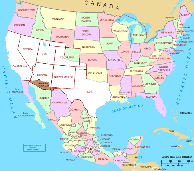
คำอธิบายMexican Cession in Mexican View.PNG
Mexican Cession in Mexican View
วันที่
01/07/2009
แหล่งที่มา
U.S._Territorial_Acquisitions.png
ผู้สร้างสรรค์
United States federal government (en:User:Black and White converted it from JPEG to PNG and retouched it)
การอนุญาต (การใช้ไฟล์นี้ใหม่)
This map was obtained from an edition of the National Atlas of the United States. Like almost all works of the U.S. federal government, works from the National Atlas are in the public domain.
Se agrego la totalidad del territorio Mexicano y la division de los estados de Mexico. Was added the entire Mexican territory and the division of states of Mexico.
{{Information |Description= Mexican Cession in Mexican View |Source= U.S._Territorial_Acquisitions.png |Date= 01/07/2009 |Author=United States federal government (en:User:Black and White converted it from JPEG to PNG and retouched it) |Permission=This map
Wikipedia:Kartenwerkstatt/Archiv/Zurückgewiesene und zurückgestellte Aufträge 2016
Benutzer:Predatorix/Mexikanische Rückführung
Treaty of Guadalupe Hidalgo
Mexican Repatriation
Mexican–American War
Second Federal Republic of Mexico
User:Jacobfrid/sandbox
Portal:Hispanic and Latino Americans/Featured picture/Archive
Portal:Hispanic and Latino Americans/Featured picture/107
User:Falcaorib
Suroeste de Estados Unidos
Guerra entre los Comanches y México
Segunda República Federal (México)
Usuario:Moulderkurt.5/Taller
Guadalupe Hidalgon rauha
James K. Polk
Conquête de l'Ouest
Présidence de James K. Polk
Guadalupe Hidalgó-i béke
美帝國主義
มกราคม 22, 2023
ไฟล, mexican, cession, mexican, view, ไฟล, ประว, ไฟล, หน, าท, ภาพน, การใช, ไฟล, วนกลางขนาดของต, วอย, างน, กเซล, ความละเอ, ยดอ, กเซล, กเซล, กเซล, กเซล, ภาพท, ความละเอ, ยดส, งกว, 8206, กเซล, ขนาดไฟล, โลไบต, ชน, ดไมม, image, ปภาพหร, อไฟล, เส, ยงน, นฉบ, บอย, คอมมอ. ifl prawtiifl hnathimiphaphni karichiflswnklangkhnadkhxngtwxyangni 680 599 phikesl khwamlaexiydxun 272 240 phikesl 545 480 phikesl 872 768 phikesl 1 068 941 phikesl duphaphthimikhwamlaexiydsungkwa 8206 1 068 941 phikesl khnadifl 135 kiolibt chnidimm image png rupphaphhruxiflesiyngni tnchbbxyuthi khxmmxns raylaexiyddanlang epnkhxkhwamthiaesdngphlcak ifltnchbbinkhxmmxns khxmmxnsepnewbistinokhrngkarsahrbekbrwbrwmsuxesri thi khunsamarthchwyid phaphaephnthini khwrcathuksrangihmepnkrafiksewketxr sungmikhxdixikhlayprakar duephimetimthikhxmmxns suxtxngkarekbkwadsahrbsarsnethsephimetim hakphaphnimiinrupaebbkrafiksewketxrxyuaelw krunaxpohldaelaaethnthiaemaebbnidwy vector version available i chuxphaphihm i aenanaepnxyangyingihtngchuxiflewketxrihmnninrupaebb Mexican Cession in Mexican View svg aelwisaemaebb Vector version available hrux Vva sungimtxngichpharamietxr chuxphaphihmkhwamyx khaxthibayMexican Cession in Mexican View PNG Mexican Cession in Mexican Viewwnthi 01 07 2009aehlngthima U S Territorial Acquisitions pngphusrangsrrkh United States federal government en User Black and White converted it from JPEG to PNG and retouched it karxnuyat karichiflniihm This map was obtained from an edition of the National Atlas of the United States Like almost all works of the U S federal government works from the National Atlas are in the public domain karxnuyatichsiththi Public domain Public domain false falsekhapheca phuthuxlikhsiththiinnganni khxmxbnganihepnsatharnsmbti prakasnimiphlthwolkinbangpraeths karkrathadngklawxacimsamarththaidtamkdhmaykhaphecaxnuyatihthukkhnmisiththiinkarichiflniinthukehtuphlkarich odyimmimienguxnikh ewnaetkdhmayimxnuyatihthaechnnnkhabrryayodyyxithyephimkhabrryaythrrthdediywephuxkhyaykhwamwaiflnimixairixethmthiaesdngxyuiniflniprakxbdwysthanalikhsiththicopyrighted dedicated to the public domain by copyright holder xngkvssyyaxnuyatreleased into the public domain by the copyright holder xngkvs prawtiifl khlikwnthi ewlaephuxduiflthipraktinkhnann wnthi ewlarupyxkhnadphuichkhwamehn pccubn04 02 23 knyayn 25541 068 941 135 kiolibt Hpav7ajustes 11 39 18 mkrakhm 25531 068 941 135 kiolibt JaimikoSe agrego la totalidad del territorio Mexicano y la division de los estados de Mexico Was added the entire Mexican territory and the division of states of Mexico 04 59 2 krkdakhm 25521 066 721 107 kiolibt Jaimiko Information Description Mexican Cession in Mexican View Source U S Territorial Acquisitions png Date 01 07 2009 Author United States federal government en User Black and White converted it from JPEG to PNG and retouched it Permission This map hnathimiphaphni hnatxipni oyngmathiphaphni prawtisastrshrth karichiflswnklang wikixuntxipniichiflni karichbn af wikipedia org Meksikaans Amerikaanse Oorlog karichbn ca wikipedia org Sud oest dels Estats Units karichbn cs wikipedia org Mexicko americka valka karichbn de wikipedia org Geschichte Kaliforniens Wikipedia Kartenwerkstatt Archiv Zuruckgewiesene und zuruckgestellte Auftrage 2016 Benutzer Predatorix Mexikanische Ruckfuhrung karichbn en wikipedia org Colorado Treaty of Guadalupe Hidalgo Mexican Repatriation Mexican American War Second Federal Republic of Mexico User Jacobfrid sandbox Portal Hispanic and Latino Americans Featured picture Archive Portal Hispanic and Latino Americans Featured picture 107 User Falcaorib karichbn es wikipedia org Colorado Suroeste de Estados Unidos Guerra entre los Comanches y Mexico Segunda Republica Federal Mexico Usuario Moulderkurt 5 Taller karichbn fa wikipedia org جنگ آمریکا و مکزیک karichbn fi wikipedia org Meksikon Yhdysvaltain sota Guadalupe Hidalgon rauha karichbn fr wikipedia org Traite de Guadalupe Hidalgo James K Polk Conquete de l Ouest Presidence de James K Polk karichbn hr wikipedia org Americko meksicki rat karichbn hu wikipedia org Mexikoi amerikai haboru Guadalupe Hidalgo i beke karichbn ja wikipedia org 利用者 ぎぶそん 作業場 karichbn ms wikipedia org Perang Amerika Syarikat Mexico karichbn sh wikipedia org Americko meksicki rat karichbn ta wikipedia org ம க ச க க அம ர க கப ப ர karichbn zh min nan wikipedia org Colorado karichbn zh wikipedia org 美墨戰爭 美帝國主義 ekhathungcak https th wikipedia org wiki ifl Mexican Cession in Mexican View PNG, wikipedia, วิกิ หนังสือ, หนังสือ, ห้องสมุด,