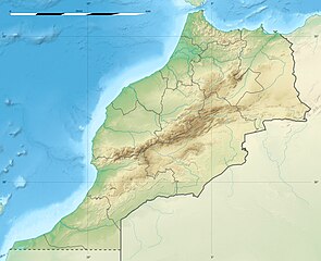
English: Blank physical map of Morocco, for geo-location purposes.
Français : Carte physique vierge du Maroc, destinée à la géolocalisation.
Scale: 1:4,000,000 (precision: 1,000 m) Equirectangular projection, WGS84 datum
Central meridian: 007° 04' 30" W
Standard parallel: 31° 46' 30" N
Geographic limits of the map:
Top: 36° 15' N
Bottom: 27° 18' N
Left: 013° 33' W
Right: 000° 36' W
วันที่
2009-11, updated 2017-02
แหล่งที่มา
งานของตัว
Sources of data:
SRTM30 Plus;
NGDC World Data Bank II (public domain);
NGDC GSHHS (public domain);
Map Library (public domain).
ผู้สร้างสรรค์
Eric Gaba (Sting - fr:Sting)
การอนุญาต (การใช้ไฟล์นี้ใหม่)
Attribution and Share-Alike required
Any use of this map can be made as long as you credit me (Eric Gaba – Wikimedia Commons user: Sting) as the author and distribute the copies and derivative works under the same license(s) that the one(s) stated below. A message with a reply address would also be greatly appreciated.
== {{int:filedesc}} == {{Location|31|46|30|N|7|04|30|W|scale:5000000}} <br/> {{Information |Description={{en|Blank physical map of Morocco, for geo-location purposes.}} {{fr|Carte physique vierge du Maroc, destinée à la gé
ไฟล, morocco, relief, location, ไฟล, ประว, ไฟล, หน, าท, ภาพน, การใช, ไฟล, วนกลาง, อม, ลเก, ยวก, บภาพขนาดของต, วอย, างน, กเซล, ความละเอ, ยดอ, กเซล, กเซล, กเซล, กเซล, ภาพท, ความละเอ, ยดส, งกว, 8206, กเซล, ขนาดไฟล, โลไบต, ชน, ดไมม, image, jpeg, ปภาพหร, อไฟล, เส, . ifl prawtiifl hnathimiphaphni karichiflswnklang khxmulekiywkbphaphkhnadkhxngtwxyangni 737 600 phikesl khwamlaexiydxun 295 240 phikesl 590 480 phikesl 944 768 phikesl 1 223 995 phikesl duphaphthimikhwamlaexiydsungkwa 8206 1 223 995 phikesl khnadifl 265 kiolibt chnidimm image jpeg rupphaphhruxiflesiyngni tnchbbxyuthi khxmmxns raylaexiyddanlang epnkhxkhwamthiaesdngphlcak ifltnchbbinkhxmmxns khxmmxnsepnewbistinokhrngkarsahrbekbrwbrwmsuxesri thi khunsamarthchwyid khwamyx khaxthibayMorocco relief location map jpg English Blank physical map of Morocco for geo location purposes Francais nbsp Carte physique vierge du Maroc destinee a la geolocalisation Scale 1 4 000 000 precision 1 000 m Equirectangular projection WGS84 datum Central meridian 007 04 30 W Standard parallel 31 46 30 N Geographic limits of the map Top 36 15 N Bottom 27 18 N Left 013 33 W Right 000 36 W wnthi 2009 11 updated 2017 02 aehlngthima ngankhxngtw Sources of data SRTM30 Plus NGDC World Data Bank II public domain NGDC GSHHS public domain Map Library public domain phusrangsrrkh Eric Gaba Sting fr Sting karxnuyat karichiflniihm Attribution and Share Alike required Any use of this map can be made as long as you credit me Eric Gaba Wikimedia Commons user Sting as the author and distribute the copies and derivative works under the same license s that the one s stated below A message with a reply address would also be greatly appreciated ewxrchnxun Equivalent administrative map taaehnngthitngklxng31 nbsp 46 nbsp 30 nbsp ehnux 7 nbsp 04 nbsp 30 nbsp tawntk nbsp phaphniaelaphaphxun n sthanthiediywknthi OpenStreetMap31 775000 7 075000 karxnuyatichsiththi khapheca inthanaphuthuxlikhsiththikhxngphaphhruxsuxni xnuyatihichphaphhruxsuxniphayitenguxnikhtxipniiflnixyuphayitsyyaxnuyat khriexthifkhxmmxns aebbaesdngthima xnuyataebbediywkn 3 0 tnchbbkhunsamarth thicaaebngpn thicathasaena aeckcay aelasngngandngklawtxip thicaeriyberiyngihm thicaddaeplngngandngklaw phayitenguxnikhtxipni aesdngthima khuntxngihekiyrtiecakhxngnganxyangehmaasm odyephimlingkipyngsyyaxnuyat aelarabuhakmikarepliynaeplng khunxacthaechnniidinrupaebbidkidtamkhwr aettxngimichinlksnathiaenawaphuihxnuyatsnbsnunkhunhruxkarichngankhxngkhun xnuyataebbediywkn hakkhunddaeplng epliynrup hruxtxetimnganni khuntxngichsyyaxnuyataebbediywknhruxaebbthiehmuxnkbsyyaxnuyatthiichkbnganniethannhttps creativecommons org licenses by sa 3 0 CC BY SA 3 0 Creative Commons Attribution Share Alike 3 0 true true xnuyatihkhdlxk aeckcayaela hruxddaeprexksarniphayitenguxnikhkhxngsyyaxnuyatexksaresrikhxngknu run 1 2 hruxrunid nbcaknithixxkodymulnithisxftaewresri odyimmiswnidhamaekikh immikhxkhwampkhnaaelapkhlng saenakhxngsyyaxnuyatrwmxyuinswnchux syyaxnuyatexksaresrikhxngknuhttp www gnu org copyleft fdl html GFDL GNU Free Documentation License true truekhunsamartheluxksyyaxnuyatdngklawtamtxngkarkhabrryayodyyxithyephimkhabrryaythrrthdediywephuxkhyaykhwamwaiflnimixairfrngessCarte administrative du Royaume du Marocxahrbخريطة المملكة المغربيةixethmthiaesdngxyuiniflniprakxbdwyphusrangbangkhathiimmiixethmwikisnethshnathikhxngwtthuphayitpraphcnni changphaphsthanalikhsiththimilikhsiththisyyaxnuyatGNU Free Documentation License version 1 2 or later nbsp xngkvsCreative Commons Attribution ShareAlike 3 0 Unported nbsp xngkvsthimakhxngiflkarsrangdngedimodyphuxpohldMIME type nbsp xngkvsimage jpegcoordinates of the point of view nbsp xngkvs31 46 30 N 7 4 30 WchuxphusrangsrrkhStingchuxphuichwikimiediy Stingyuxaraexl http commons wikimedia org wiki User Sting prawtiifl khlikwnthi ewlaephuxduiflthipraktinkhnann wnthi ewlarupyxkhnadphuichkhwamehn pccubn03 55 11 kumphaphnth 25601 223 995 265 kiolibt StingUpdated regions borders as since 2015 20 11 19 krkdakhm 25531 223 995 234 kiolibt StingColor profile 03 31 22 phvscikayn 25521 223 995 240 kiolibt StingPutting back the southern dotted boundary regarding Western Sahara 039 s location map 08 23 21 phvscikayn 25521 223 995 239 kiolibt StingDrawback for one correction 08 10 21 phvscikayn 25521 223 995 240 kiolibt StingSeveral little corrections 07 09 21 phvscikayn 25521 223 995 241 kiolibt Sting int filedesc Location 31 46 30 N 7 04 30 W scale 5000000 lt br gt Information Description en Blank physical map of Morocco for geo location purposes fr Carte physique vierge du Maroc destinee a la ge hnathimiphaphni hnatxipni oyngmathiphaphni chfchawn fasxlbaly rabt aemaebb Location map Morocco mxdul Location map data Morocco mxdul Location map data Morocco doc karichiflswnklang wikixuntxipniichiflni karichbn ar wikipedia org الجديدة المغرب وزان آسفي شفشاون تارودانت المدرسة المحمدية للمهندسين ميضار الدريوش اليوسفية المغرب جبل تسوكا ابن الطيب زلزال أكادير 1960 أولاد الطيب دار الكبداني آيت مايت أمجاو أزلاف إفرني بني مرغنين أولاد أمغار تروكوت تفرسيت تليليت أمهاجر وردانة جماعة أمطالسة أولاد بوبكر عين الزهرة تمسمان دمنات بوناصر كرونا المغرب سيدي إسماعيل تافراوت المغرب قالب خريطة مواقع المغرب أكادير بوكراع إقليم الدريوش الوليدية المغرب البدوزة إجرماواس بودينار أيت باها بيوڭرى إيغرم سيدي عابد المغرب ويسلان أولاد سلمان سد الوحدة المغرب الشرف مغوغة dukarichthwolkephimetimkhxngiflnikhxmulekiywkbphaph phaphnimikhxmulephimetim sungswnihymacakklxngdicitxlhruxsaeknenxrthisamarthekbkhxmuldngklawiwrwmkbphaphid thaphaphnithukprbprungaekikhhruxepliynaeplngcakedim khxmulbangxyangcayngkhngimepliynaeplngehmuxnphaphthithukprbprungaekikhnnphuthrnglikhsiththiCC Attribution ShareAlike http creativecommons org licenses by sa 3 0 karcdwangphaphpktikhwamlaexiydaenwnxn90 dpikhwamlaexiydaenwtng90 dpisxftaewrthiichAdobe Photoshop CC 2017 Windows aekikhphaphlasud18 52 10 kumphaphnth 2560sepssisRGBewlathiaeplngepndicithl16 50 10 kumphaphnth 2560wnthiaekikhkhxmulemtalasud16 52 10 kumphaphnth 2560sthanalikhsiththimilikhsiththiID echphaakhxngexksartnchbbxmp did 8fe4fd5b 10d9 8140 8db7 d94401a90cb6run IIM2 ekhathungcak https th wikipedia org wiki ifl Morocco relief location map jpg, wikipedia, วิกิ หนังสือ, หนังสือ, ห้องสมุด,