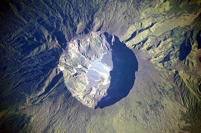
fbpx
วิกิพีเดีย

Mount Tambora Volcano, Sumbawa Island, Indonesia

ดูภาพที่มีความละเอียดสูงกว่า(4,256 × 2,828 พิกเซล, ขนาดไฟล์: 2.29 เมกะไบต์, ชนิดไมม์: image/jpeg)

รูปภาพหรือไฟล์เสียงนี้ ต้นฉบับอยู่ที่ คอมมอนส์ รายละเอียดด้านล่าง เป็นข้อความที่แสดงผลจาก ไฟล์ต้นฉบับในคอมมอนส์
คอมมอนส์เป็นเว็บไซต์ในโครงการสำหรับเก็บรวบรวมสื่อเสรี ที่ คุณสามารถช่วยได้

ความย่อ

คำอธิบาย
Bahasa Indonesia: Foto astronot ini menggambarkan kaldera puncak gunung Tambora. Kaldera ini berdiameter 6 km dan terbentuk dengan dalam 1.100 m ketika puncak Gunung Tambora yang berketinggian kira-kira 4.000 m telah tidak ada, dan ruangan magma di bawahnya menjadi kosong setelah letusan tahun 1815. Saat ini dasar kawah menjadi lokasi sebuah danau air tawar musiman, deposit sedimen yang belum lama, aliran lava kecil, dan kubah yang terbentuk selama abad kesembilan belas dan kedua puluh. Deposit tephra yang berlapis terlihat di sepanjang sisi barat laut bibir kawah. Fumarol aktif, atau ventilasi uap, masih ada di kaldera.
English: This detailed astronaut photograph depicts the summit caldera of the volcano. The huge caldera—6 kilometers in diameter and 1,100 meters deep—formed when Tambora’s estimated 4,000-meter-high peak was removed, and the magma chamber below emptied during the 1815 eruption. Today the crater floor is occupied by an ephemeral freshwater lake, recent sedimentary deposits, and minor lava flows and domes emplaced during the nineteenth and twentieth centuries. Layered tephra deposits are visible along the north-western crater rim. Active fumaroles, or steam vents, still exist in the caldera.
Français : Photographie de la caldera sommitale du mont Tambora, en Indonésie. Cette caldera est immense, avec 6 km de diamètre et 1000 m de profondeur. Sa formation date de l'éruption de 1815, qui est l'éruption volcanique la plus importante de l'histoire. Avant l'éruption, le Tambora formait un pic d'une altitude d'environ 4000 m. Aujourd'hui, les lèvres de la caldera sont à 2500 m d'altitude. Le fond de la caldera est occupé par un lac temporaire, des coulées de laves provenant d'éruptions mineures et des fumeroles.
Deutsch: Krater des Tambora
Русский: Эта фотография подробно показывает кальдеру вулкана Тамбора, имеющую 6 — 7 километров в диаметре. Она образовалась в результате катастрофического извержения 1815 года, когда верхняя часть вулкана обрушилась из-за опустения магматической камеры под ним. Сегодня внутри кальдеры находится небольшое пресноводное озеро, лавовые купола, а в северо-западной части кратера имеются многослойные отложения тефры. Кроме того кальдере присуща фумарольная активность.


ISS Crew Earth Observations: ISS020-E-06563
Identification
Mission ISS020 (Expedition 20)
Roll E
Frame 06563
Country or Geographic Name Indonesia
Features MOUNT TAMBORA, SUMBAWA ISLAND, CALDERA
Center Point Latitude -8.3° N
Center Point Longitude 118.0° E
Camera
Camera Tilt 27°
Camera Focal Length 800 mm
Camera Nikon D3
Film 4256 x 2832 pixel CMOS sensor, 36.0mm x 23.9mm, total pixels: 12.87 million, Nikon FX format.
Quality
Percentage of Cloud Cover 0-10%
Nadir What is Nadir?
Date 2009-06-03
Time 00:08:06
Nadir Point Latitude -8.2° N
Nadir Point Longitude 119.6° E
Nadir to Photo Center Direction West
Sun Azimuth 60°
Spacecraft Altitude 189 nautical miles (350 km)
Sun Elevation Angle 26°
Orbit Number 371
Original image caption
On April 10, 1815, the Tambora Volcano produced the largest eruption in history. An estimated 150 cubic kilometers of tephra—exploded rock and ash—resulted, with ash from the eruption recognized at least 1,300 kilometers away to the northwest. While the April 10 eruption was catastrophic, historical records and geological analysis of eruption deposits indicate that the volcano had been active between 1812 and 1815. Enough ash was put into the atmosphere from the April 10 eruption to reduce incident sunlight on the Earth’s surface and cause global cooling, resulting in the 1816 “year without a summer.”

This detailed astronaut photograph depicts the summit caldera of the volcano. The huge caldera—6 kilometers in diameter and 1,100 meters deep—formed when Tambora’s estimated 4,000-meter-high peak was removed, and the magma chamber below emptied during the April 10 eruption. Today the crater floor is occupied by an ephemeral freshwater lake, recent sedimentary deposits, and minor lava flows and domes emplaced during the nineteenth and twentieth centuries. Layered tephra deposits are visible along the northwestern crater rim. Active fumaroles, or steam vents, still exist in the caldera.

In 2004, scientists discovered the remains of a village, that was once underground but now has resurfaced. They found two adults buried under approximately 3 meters of ash in a gully on Tambora’s flank—remnants of the former Kingdom of Tambora preserved by the 1815 eruption that destroyed it. The similarity of the Tambora remains to those associated with the AD 79 eruption of Mount Vesuvius has led to the Tambora site’s description as “the Pompeii of the East.”

วันที่ Published 2009-07-19. Taken 2009-03-06.
แหล่งที่มา Image and and English description: Mount Tambora Volcano, Sumbawa Island, Indonesia, NASA Earth Observatory. 2nd version: นำเข้าจาก de.wikipedia มายังคอมมอนส์; originally from https://eol.jsc.nasa.gov/SearchPhotos/photo.pl?mission=ISS020&roll=E&frame=06563
ผู้สร้างสรรค์ This image was taken by the NASA Expedition 20 crew.
ตำแหน่งที่ตั้งกล้อง8° 14′ 34.4″ ใต้, 117° 59′ 45.2″ ตะวันออก ภาพนี้และภาพอื่น ๆ ณ สถานที่เดียวกันที่ OpenStreetMap
This image or video was catalogued by Johnson Space Center of the United States National Aeronautics and Space Administration (NASA) under Photo ID: ISS020-E-6563.

This tag does not indicate the copyright status of the attached work. A normal copyright tag is still required. See Commons:Licensing.

العربية  беларуская (тарашкевіца)  български  català  čeština  dansk  Deutsch  English  español  فارسی  français  galego  magyar  հայերեն  Bahasa Indonesia  italiano  日本語  македонски  മലയാളം  Nederlands  polski  português  русский  sicilianu  Türkçe  українська  简体中文  繁體中文  +/−
ภาพนี้ได้รับการประเมินภายใต้ เกณฑ์ภาพอันทรงคุณค่า และถือว่าเป็นภาพอันทรงคุณค่าที่สุดในคอมมอนส์ ภายใต้ขอบเขต Mount Tambora

 นี่คือภาพคัดสรรในวิกิพีเดียภาษาอินโดนีเซีย (Gambar pilihan) และ คือ ถือว่าเป็น ภาพอย่างใดอย่างหนึ่งที่ดีที่สุด

ถ้าคิดว่าไฟล์นี้ควรจะให้ความสำคัญกับวิกิมีเดียคอมมอนส์เป็นอย่างดี อย่าลังเลที่จะ เสนอชื่อ หากคุณมีภาพที่มีคุณภาพ คล้ายคลึงกัน ที่จะสามารถเผยแพร่ได้ตาม สัญญาอนุญาตที่เหมาะสม, ให้แน่ใจว่า คุณได้ อัปโหลด กำหนดสัญญาอนุญาต และได้ เสนอชื่อแล้ว

การอนุญาตใช้สิทธิ

Original upload log (2nd version)

The original description page was here. All following user names refer to de.wikipedia.
  • 2009-07-23 01:35 Geoethno 1440×960× (469914 bytes) {{Information |Beschreibung = Krater des Tambora |Quelle = http://earthobservatory.nasa.gov/images/imagerecords/39000/39412/ISS020-E-06563_l

คำบรรยายโดยย่อ

เพิ่มคำบรรยายทรรทัดเดียวเพื่อขยายความว่าไฟล์นี้มีอะไร

ไอเทมที่แสดงอยู่ในไฟล์นี้

ประกอบด้วย

ปริภูมิ

การถ่ายภาพ

แป้นพิมพ์เกษมณี

โลก

ภูเขาไฟ

สถานะลิขสิทธิ์

สาธารณสมบัติ

determination method อังกฤษ: work of the federal government of the United States อังกฤษ

coordinates of the point of view อังกฤษ

8°14'34.400"S, 117°59'45.200"E

บันทึกภาพด้วย

Nikon D3 อังกฤษ

catalog code อังกฤษ

ISS020-E-6563

แค็ตตาล็อก: Media catalogue of the Johnson Space Center อังกฤษ

เหตุการณ์สำคัญ

Expedition 20 อังกฤษ

ประวัติไฟล์

คลิกวันที่/เวลาเพื่อดูไฟล์ที่ปรากฏในขณะนั้น

วันที่/เวลารูปย่อขนาดผู้ใช้ความเห็น
ปัจจุบัน19:55, 24 กุมภาพันธ์ 25544,256 × 2,828 (2.29 เมกะไบต์)Originalwanahigher res
00:37, 16 เมษายน 25531,440 × 960 (619 กิโลไบต์)RosenzweigReverted to version as of 11:04, 19 July 2009. Back to Commons version.
00:37, 16 เมษายน 25531,440 × 960 (459 กิโลไบต์)Rosenzweigdifferent version from de.wp
18:04, 19 กรกฎาคม 25521,440 × 960 (619 กิโลไบต์)Originalwana{{Information |Description={{en|1=This detailed astronaut photograph depicts the summit caldera of the volcano. The huge caldera—6 kilometres in diameter and 1,100 meters deep—formed when Tambora’s estimated 4,000-meter-high peak was removed, and th

หน้าต่อไปนี้ โยงมาที่ภาพนี้:

การใช้ไฟล์ส่วนกลาง

วิกิอื่นต่อไปนี้ใช้ไฟล์นี้:

  • Tambora
  • Seznam sopek Indonésie
  • Seznam velkých sopečných erupcí
  • Tambora
  • List of ribus
  • การใช้บน en.wikiversity.org
    • Volcanoes/Mount Tambora
    • Draft:Keynote lectures/Craters by radiation
    • User:Marshallsumter/Rocks/Rocky objects/Earth
    • User:Marshallsumter/Radiation astronomy/Craters
    • Orbital platforms
  • การใช้บน en.wikivoyage.org
    • Mount Tambora
  • Utilisateur:Vyk/Tambora
  • Éruption du Tambora en 1815
  • Wikipédia:Le Bistro/10 avril 2022
  • Wikipedia:Gambar pilihan/Usulan/2011
  • Wikipedia:Gambar pilihan/2011
  • Wikipedia:Gambar pilihan/Usulan/2011/54 Intro
  • Wikipedia:Gambar pilihan/54 2011
  • Wikipedia:Gambar pilihan/Tempat/Landskap
  • Eruzione del Tambora del 1815
  • Портал:Индонезия/Лучшие статьи
  • Портал:Индонезия/Избранное изображение
  • ดูการใช้ทั่วโลกเพิ่มเติมของไฟล์นี้

    ข้อมูลเกี่ยวกับภาพ

    ไฟล, mount, tambora, volcano, sumbawa, island, indonesia, ไฟล, ประว, ไฟล, หน, าท, ภาพน, การใช, ไฟล, วนกลาง, อม, ลเก, ยวก, บภาพขนาดของต, วอย, างน, กเซล, ความละเอ, ยดอ, กเซล, กเซล, กเซล, กเซล, กเซล, กเซล, ภาพท, ความละเอ, ยดส, งกว, 8206, กเซล, ขนาดไฟล, เมกะไบต, ช. ifl prawtiifl hnathimiphaphni karichiflswnklang khxmulekiywkbphaphkhnadkhxngtwxyangni 800 532 phikesl khwamlaexiydxun 320 213 phikesl 640 425 phikesl 1 024 680 phikesl 1 280 851 phikesl 2 560 1 701 phikesl 4 256 2 828 phikesl duphaphthimikhwamlaexiydsungkwa 8206 4 256 2 828 phikesl khnadifl 2 29 emkaibt chnidimm image jpeg rupphaphhruxiflesiyngni tnchbbxyuthi khxmmxns raylaexiyddanlang epnkhxkhwamthiaesdngphlcak ifltnchbbinkhxmmxns khxmmxnsepnewbistinokhrngkarsahrbekbrwbrwmsuxesri thi khunsamarthchwyid khwamyx khaxthibayMount Tambora Volcano Sumbawa Island Indonesia jpg Bahasa Indonesia Foto astronot ini menggambarkan kaldera puncak gunung Tambora Kaldera ini berdiameter 6 km dan terbentuk dengan dalam 1 100 m ketika puncak Gunung Tambora yang berketinggian kira kira 4 000 m telah tidak ada dan ruangan magma di bawahnya menjadi kosong setelah letusan tahun 1815 Saat ini dasar kawah menjadi lokasi sebuah danau air tawar musiman deposit sedimen yang belum lama aliran lava kecil dan kubah yang terbentuk selama abad kesembilan belas dan kedua puluh Deposit tephra yang berlapis terlihat di sepanjang sisi barat laut bibir kawah Fumarol aktif atau ventilasi uap masih ada di kaldera English This detailed astronaut photograph depicts the summit caldera of the volcano The huge caldera 6 kilometers in diameter and 1 100 meters deep formed when Tambora s estimated 4 000 meter high peak was removed and the magma chamber below emptied during the 1815 eruption Today the crater floor is occupied by an ephemeral freshwater lake recent sedimentary deposits and minor lava flows and domes emplaced during the nineteenth and twentieth centuries Layered tephra deposits are visible along the north western crater rim Active fumaroles or steam vents still exist in the caldera Francais Photographie de la caldera sommitale du mont Tambora en Indonesie Cette caldera est immense avec 6 km de diametre et 1000 m de profondeur Sa formation date de l eruption de 1815 qui est l eruption volcanique la plus importante de l histoire Avant l eruption le Tambora formait un pic d une altitude d environ 4000 m Aujourd hui les levres de la caldera sont a 2500 m d altitude Le fond de la caldera est occupe par un lac temporaire des coulees de laves provenant d eruptions mineures et des fumeroles Deutsch Krater des Tambora Russkij Eta fotografiya podrobno pokazyvaet kalderu vulkana Tambora imeyushuyu 6 7 kilometrov v diametre Ona obrazovalas v rezultate katastroficheskogo izverzheniya 1815 goda kogda verhnyaya chast vulkana obrushilas iz za opusteniya magmaticheskoj kamery pod nim Segodnya vnutri kaldery nahoditsya nebolshoe presnovodnoe ozero lavovye kupola a v severo zapadnoj chasti kratera imeyutsya mnogoslojnye otlozheniya tefry Krome togo kaldere prisusha fumarolnaya aktivnost ISS Crew Earth Observations ISS020 E 06563 IdentificationMission ISS020 Expedition 20 Roll EFrame 06563Country or Geographic Name IndonesiaFeatures MOUNT TAMBORA SUMBAWA ISLAND CALDERACenter Point Latitude 8 3 NCenter Point Longitude 118 0 ECameraCamera Tilt 27 Camera Focal Length 800 mmCamera Nikon D3Film 4256 x 2832 pixel CMOS sensor 36 0mm x 23 9mm total pixels 12 87 million Nikon FX format QualityPercentage of Cloud Cover 0 10 Nadir What is Nadir Date 2009 06 03Time 00 08 06Nadir Point Latitude 8 2 NNadir Point Longitude 119 6 ENadir to Photo Center Direction WestSun Azimuth 60 Spacecraft Altitude 189 nautical miles 350 km Sun Elevation Angle 26 Orbit Number 371Original image captionOn April 10 1815 the Tambora Volcano produced the largest eruption in history An estimated 150 cubic kilometers of tephra exploded rock and ash resulted with ash from the eruption recognized at least 1 300 kilometers away to the northwest While the April 10 eruption was catastrophic historical records and geological analysis of eruption deposits indicate that the volcano had been active between 1812 and 1815 Enough ash was put into the atmosphere from the April 10 eruption to reduce incident sunlight on the Earth s surface and cause global cooling resulting in the 1816 year without a summer This detailed astronaut photograph depicts the summit caldera of the volcano The huge caldera 6 kilometers in diameter and 1 100 meters deep formed when Tambora s estimated 4 000 meter high peak was removed and the magma chamber below emptied during the April 10 eruption Today the crater floor is occupied by an ephemeral freshwater lake recent sedimentary deposits and minor lava flows and domes emplaced during the nineteenth and twentieth centuries Layered tephra deposits are visible along the northwestern crater rim Active fumaroles or steam vents still exist in the caldera In 2004 scientists discovered the remains of a village that was once underground but now has resurfaced They found two adults buried under approximately 3 meters of ash in a gully on Tambora s flank remnants of the former Kingdom of Tambora preserved by the 1815 eruption that destroyed it The similarity of the Tambora remains to those associated with the AD 79 eruption of Mount Vesuvius has led to the Tambora site s description as the Pompeii of the East wnthi Published 2009 07 19 Taken 2009 03 06 aehlngthima Image and and English description Mount Tambora Volcano Sumbawa Island Indonesia NASA Earth Observatory 2nd version naekhacak de wikipedia mayngkhxmmxns originally from https eol jsc nasa gov SearchPhotos photo pl mission ISS020 amp roll E amp frame 06563phusrangsrrkh This image was taken by the NASA Expedition 20 crew taaehnngthitngklxng8 14 34 4 it 117 59 45 2 tawnxxk phaphniaelaphaphxun n sthanthiediywknthi OpenStreetMap 8 242889 117 995889This image or video was catalogued by Johnson Space Center of the United States National Aeronautics and Space Administration NASA under Photo ID ISS020 E 6563 This tag does not indicate the copyright status of the attached work A normal copyright tag is still required See Commons Licensing العربية belaruskaya tarashkevica blgarski catala cestina dansk Deutsch English espanol فارسی francais galego magyar հայերեն Bahasa Indonesia italiano 日本語 makedonski മലയ ള Nederlands polski portugues russkij sicilianu Turkce ukrayinska 简体中文 繁體中文 phaphniidrbkarpraeminphayit eknthphaphxnthrngkhunkha aelathuxwaepnphaphxnthrngkhunkhathisudinkhxmmxns phayitkhxbekht Mount Tambora nikhuxphaphkhdsrrinwikiphiediyphasaxinodniesiy Gambar pilihan aela khux thuxwaepn phaphxyangidxyanghnungthidithisudthakhidwaiflnikhwrcaihkhwamsakhykbwikimiediykhxmmxnsepnxyangdi xyalngelthica esnxchux hakkhunmiphaphthimikhunphaph khlaykhlungkn thicasamarthephyaephridtam syyaxnuyatthiehmaasm ihaenicwa khunid xpohld kahndsyyaxnuyat aelaid esnxchuxaelw karxnuyatichsiththi Public domain Public domain false falsephaphniepnsatharnsmbti enuxngcakepnphaphthisrangkhunodyxngkhkarbriharkarbinaelaxwkasaehngchati NASA sungtamnoybaydanlikhsiththikhxngnasarabuiwwa phaphaelasuxtang khxngnasaimidrbkarkhumkhrxngodylikhsiththiykewncarabuiwwamilikhsiththi duephimthi hnanoybaydanlikhsiththikhxngnasa hrux noybaykarichphaphkhxng JPLkhaetuxn karich olokkhxngnasa ekhruxnghmayaelaekhruxngpradbkhxngnasa thukcakddwykdhmayshrthxemrikainlksna 14 khxngkhxbngkhbthangrachkarshrthxemrika swnthi 1221 ewbistkhxngnasaekbrwbrwmphaphthimacakxngkhkarxwkasosewiyt xngkhkarxwkasaehngchatirsesiy aelaxngkhkarxwkasthimiichxngkhkarxwkaskhxngshrthxemrika epncanwnmak phaphehlaniimcaepntxngepnsatharnsmbtiesmxip phaphhruxsuxthimacak klxngothrthrrsnxwkashbebil xacmilikhsiththi hakphaphhruxsuxnnimidrabuchdecnwamacak sthabnwithyasastrklxngothrthrrsnxwkas 1 phaphhruxsuxthnghmdthimacakekhruxngmuxkhxng okhrngkarsuksadwngxathityaelalmsuriya milikhsiththi karnaphaphhruxsuxcakokhrngkaripichnxkehnuxcakkarichephuxkarkhahruxephuxkarsuksa txngidrbxnuyatkxn 2 phaphthithukkhdeluxkihepn phaphdarasastrpracawn APOD bnewbistkhxng APOD xacmilikhsiththi 3 Original upload log 2nd version The original description page was here All following user names refer to de wikipedia 2009 07 23 01 35 Geoethno 1440 960 469914 bytes Information Beschreibung Krater des Tambora Quelle http earthobservatory nasa gov images imagerecords 39000 39412 ISS020 E 06563 lkhabrryayodyyxithyephimkhabrryaythrrthdediywephuxkhyaykhwamwaiflnimixairixethmthiaesdngxyuiniflniprakxbdwypriphumikarthayphaphaepnphimpheksmniolkphuekhaifsthanalikhsiththisatharnsmbtidetermination method xngkvs work of the federal government of the United States xngkvscoordinates of the point of view xngkvs8 14 34 400 S 117 59 45 200 EbnthukphaphdwyNikon D3 xngkvscatalog code xngkvsISS020 E 6563aekhttalxk Media catalogue of the Johnson Space Center xngkvsehtukarnsakhyExpedition 20 xngkvs prawtiifl khlikwnthi ewlaephuxduiflthipraktinkhnann wnthi ewlarupyxkhnadphuichkhwamehn pccubn19 55 24 kumphaphnth 25544 256 2 828 2 29 emkaibt Originalwanahigher res 00 37 16 emsayn 25531 440 960 619 kiolibt RosenzweigReverted to version as of 11 04 19 July 2009 Back to Commons version 00 37 16 emsayn 25531 440 960 459 kiolibt Rosenzweigdifferent version from de wp 18 04 19 krkdakhm 25521 440 960 619 kiolibt Originalwana Information Description en 1 This detailed astronaut photograph depicts the summit caldera of the volcano The huge caldera 6 kilometres in diameter and 1 100 meters deep formed when Tambora s estimated 4 000 meter high peak was removed and th hnathimiphaphni hnatxipni oyngmathiphaphni ekhatmobra karichiflswnklang wikixuntxipniichiflni karichbn af wikipedia org Soembawa Tambora karichbn ar wikipedia org جبل تامبورا karichbn ast wikipedia org Tambora karichbn ban wikipedia org Gunung Tambora karichbn be wikipedia org Tambora karichbn bn wikipedia org ত মব র পর বত karichbn ca wikipedia org Mont Tambora karichbn cs wikipedia org Tambora Seznam sopek Indonesie Seznam velkych sopecnych erupci karichbn da wikipedia org Tambora karichbn de wikipedia org 1815 Tambora karichbn en wikipedia org Mount Tambora List of ribus karichbn en wikiversity org Volcanoes Mount Tambora Draft Keynote lectures Craters by radiation User Marshallsumter Rocks Rocky objects Earth User Marshallsumter Radiation astronomy Craters Orbital platforms karichbn en wikivoyage org Mount Tambora karichbn eo wikipedia org Tambora karichbn es wikipedia org Tambora karichbn fa wikipedia org کوه تامبورا karichbn fr wikipedia org Tambora Utilisateur Vyk Tambora Eruption du Tambora en 1815 Wikipedia Le Bistro 10 avril 2022 karichbn fr wiktionary org sommital karichbn gl wikipedia org Monte Tambora karichbn gor wikipedia org Hu idu Tambora karichbn he wikipedia org טמבורה karichbn hr wikipedia org Tambora karichbn id wikipedia org Gunung Tambora Wikipedia Gambar pilihan Usulan 2011 Wikipedia Gambar pilihan 2011 Wikipedia Gambar pilihan Usulan 2011 54 Intro Wikipedia Gambar pilihan 54 2011 Wikipedia Gambar pilihan Tempat Landskap karichbn it wikipedia org Caldera Eruzione del Tambora del 1815 karichbn ja wikipedia org タンボラ山 karichbn ka wikipedia org ტამბორა karichbn kk wikipedia org Tambora karichbn mk wikipedia org Tambora karichbn ro wikipedia org Muntele Tambora karichbn ru wikipedia org Tambora Portal Indoneziya Luchshie stati Portal Indoneziya Izbrannoe izobrazhenie dukarichthwolkephimetimkhxngiflnikhxmulekiywkbphaph phaphnimikhxmulephimetim sungswnihymacakklxngdicitxlhruxsaeknenxrthisamarthekbkhxmuldngklawiwrwmkbphaphid thaphaphnithukprbprungaekikhhruxepliynaeplngcakedim khxmulbangxyangcayngkhngimepliynaeplngehmuxnphaphthithukprbprungaekikhnnphuphlitklxngNIKON CORPORATIONrunkhxngklxngNIKON D3ewlaepidhnaklxng1 2 500 winathi 0 0004 khaexff 5 6xtrakhwamerw ISO200ewlathibnthukphaph00 08 3 mithunayn 2552khwamyawofkselns800 mm karcdwangphaphpktikhwamlaexiydaenwnxn240 dpikhwamlaexiydaenwtng240 dpisxftaewrthiichMicrosoft Windows Photo Gallery 6 0 6001 18000aekikhphaphlasud12 54 24 kumphaphnth 2554opraekrmexksophechxrkahndkhwamiwchtetxrepnhlk s runexksif Exif 2 21ewlathiaeplngepndicithl00 08 3 mithunayn 2552khwamerwchtetxr11 287712kharurbaesng A 4 970854rurbaesngkwangsud5 APEX f 5 66 ohmdkarwdaesngspxtaesngimthrabaeflchimichaeflchesiywwinathi wnthi ewla00esiywwinathi wnthi ewlatnchbb00esiywwinathi wnthi ewlathidiciiths00sepssisRGBwithikarwdesnesxrcudediywkarpramwlphaphophlessspktiohmdexksophechxrexksophechxrxtonmtiiwtbalansiwtbalansxtonmtidicithlsum1rayaofksinfilm 35 mm 800 mm chnidsinaekhpecxrpktikhwamepribbtangpktikhwamximsipktikhwamkhmpktirayahangwtthuimthrab ekhathungcak https th wikipedia org wiki ifl Mount Tambora Volcano Sumbawa Island Indonesia jpg, wikipedia, วิกิ หนังสือ, หนังสือ, ห้องสมุด,

    บทความ

    , อ่าน, ดาวน์โหลด, ฟรี, ดาวน์โหลดฟรี, mp3, วิดีโอ, mp4, 3gp, jpg, jpeg, gif, png, รูปภาพ, เพลง, เพลง, หนัง, หนังสือ, เกม, เกม