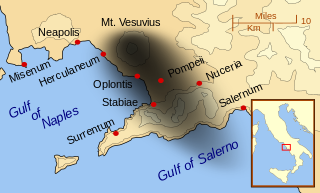
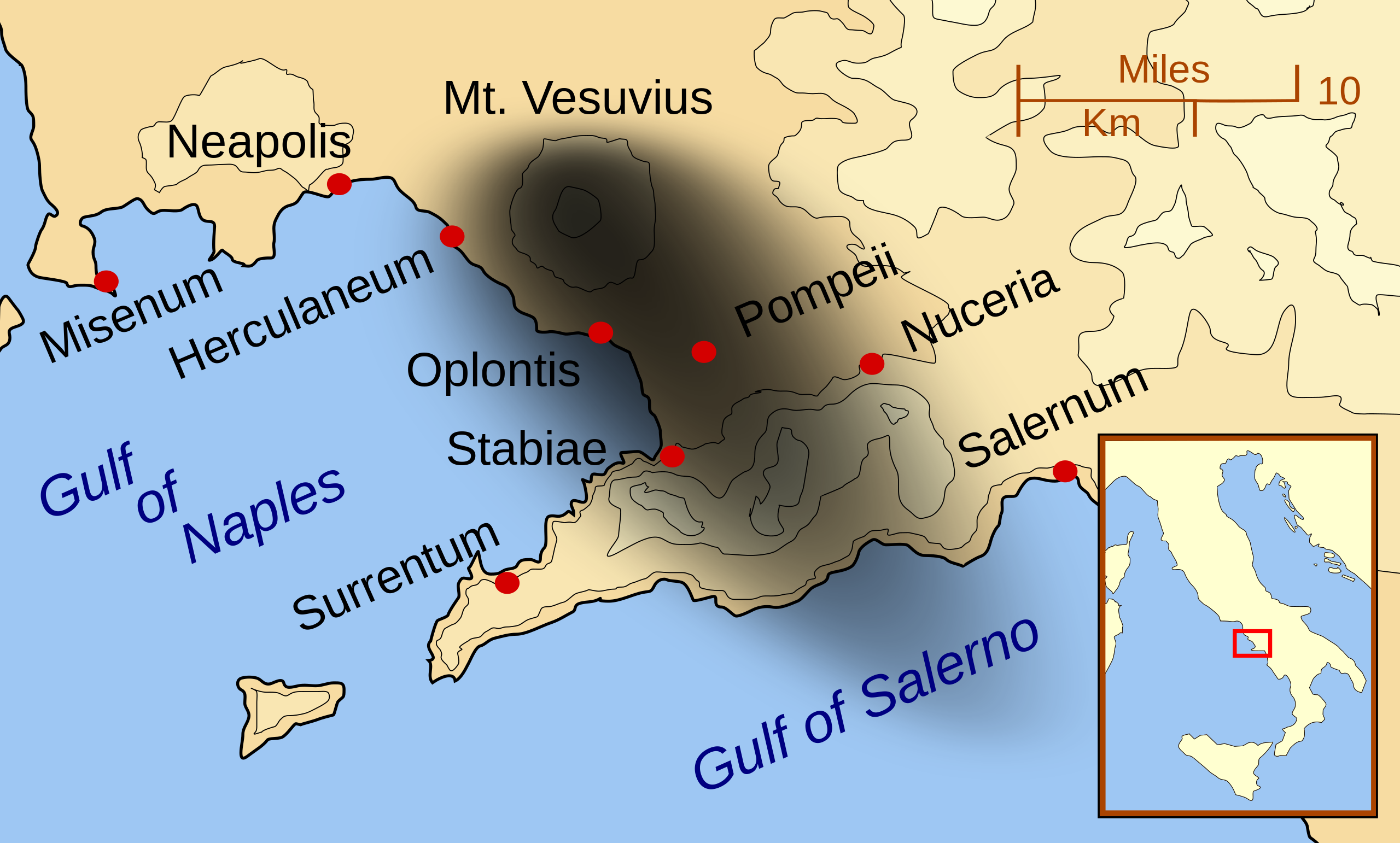
English: A map showing the cities and towns affected by the eruption of Mount Vesuvius in 79 AD. The general shape of the ash and cinder fall (see w:en:pyroclast) is shown by the dark area to the southeast of Mt Vesuvius. (P.S. It seems strange to show the modern day English names for the two bodies of water - I am open to suggestions). This map shows lines and uses the Mercator projection (although that is not important on a map of this scale). North is, as usual, at the top of the map.
{{Information |Description=A map showing the cities and town affected by the eruption of Mount Vesuvius in 79 AD. The general shape of the ash and cinder fall is shown by the dark area to the southeast of Mt Vesuvious. |Source=self-made |Date=October 200
ไฟล, vesuvius, eruption, ไฟล, ประว, ไฟล, หน, าท, ภาพน, การใช, ไฟล, วนกลาง, อม, ลเก, ยวก, บภาพขนาดของต, วอย, าง, ของไฟล, กเซล, ความละเอ, ยดอ, กเซล, กเซล, กเซล, กเซล, กเซล, ภาพท, ความละเอ, ยดส, งกว, 8206, ไฟล, กเซล, ขนาดไฟล, โลไบต, ปภาพหร, อไฟล, เส, ยงน, นฉบ, บอ. ifl prawtiifl hnathimiphaphni karichiflswnklang khxmulekiywkbphaphkhnadkhxngtwxyang PNG nikhxngifl SVG ni 800 482 phikesl khwamlaexiydxun 320 193 phikesl 640 386 phikesl 1 024 617 phikesl 1 280 771 phikesl 2 560 1 542 phikesl duphaphthimikhwamlaexiydsungkwa 8206 ifl SVG 800 482 phikesl khnadifl 87 kiolibt rupphaphhruxiflesiyngni tnchbbxyuthi khxmmxns raylaexiyddanlang epnkhxkhwamthiaesdngphlcak ifltnchbbinkhxmmxns khxmmxnsepnewbistinokhrngkarsahrbekbrwbrwmsuxesri thi khunsamarthchwyid khwamyx khaxthibayMt Vesuvius 79 AD eruption svg English A map showing the cities and towns affected by the eruption of Mount Vesuvius in 79 AD The general shape of the ash and cinder fall see w en pyroclast is shown by the dark area to the southeast of Mt Vesuvius P S It seems strange to show the modern day English names for the two bodies of water I am open to suggestions This map shows lines and uses the Mercator projection although that is not important on a map of this scale North is as usual at the top of the map wnthi tulakhm ph s 2550aehlngthima ngankhxngtwphusrangsrrkh MapMasterewxrchnxun aekikh English francais Latina Nederlands portugues makedonski russkij 中文 עברית ifl SVG nimikhxkhwamthisamarthaeplid odyichekhruxngmuxaepbphasa SVG hruxichtwaekikh SVG idkid sahrbkhxmulephimetim duthiekiywkbkaraepliflkarxnuyatichsiththi khapheca inthanaphuthuxlikhsiththikhxngphaphhruxsuxni xnuyatihichphaphhruxsuxniphayitenguxnikhtxipni xnuyatihkhdlxk aeckcayaela hruxddaeprexksarniphayitenguxnikhkhxngsyyaxnuyatexksaresrikhxngknu run 1 2 hruxrunid nbcaknithixxkodymulnithisxftaewresri odyimmiswnidhamaekikh immikhxkhwampkhnaaelapkhlng saenakhxngsyyaxnuyatrwmxyuinswnchux syyaxnuyatexksaresrikhxngknuhttp www gnu org copyleft fdl html GFDL GNU Free Documentation License true trueiflnixyuphayitsyyaxnuyatkhriexthifkhxmmxns runaesdngthima xnuyataebbediywkn 3 0 tnchbb 2 5 thwip 2 0 thwip aela 1 0 thwipkhunsamarth thicaaebngpn thicathasaena aeckcay aelasngngandngklawtxip thicaeriyberiyngihm thicaddaeplngngandngklaw phayitenguxnikhtxipni aesdngthima khuntxngihekiyrtiecakhxngnganxyangehmaasm odyephimlingkipyngsyyaxnuyat aelarabuhakmikarepliynaeplng khunxacthaechnniidinrupaebbidkidtamkhwr aettxngimichinlksnathiaenawaphuihxnuyatsnbsnunkhunhruxkarichngankhxngkhun xnuyataebbediywkn hakkhunddaeplng epliynrup hruxtxetimnganni khuntxngichsyyaxnuyataebbediywknhruxaebbthiehmuxnkbsyyaxnuyatthiichkbnganniethannhttps creativecommons org licenses by sa 3 0 CC BY SA 3 0 Creative Commons Attribution Share Alike 3 0 true truekhunsamartheluxksyyaxnuyatdngklawtamtxngkar AnnotationsInfoFieldThis image is annotated View the annotations at Commons229 68 91 77 652 396 VesuviuskhabrryayodyyxithyephimkhabrryaythrrthdediywephuxkhyaykhwamwaiflnimixairxngkvsRepresenting the direction and distance of ash and debris ejected during the eruption of Mount Vesuvius in 79AD ixethmthiaesdngxyuiniflniprakxbdwyphusrangbangkhathiimmiixethmwikisnethschuxphusrangsrrkh MapMasteryuxaraexl https commons wikimedia org wiki user MapMasterchuxphuichwikimiediy MapMastersthanalikhsiththimilikhsiththisyyaxnuyatCreative Commons Attribution ShareAlike 3 0 Unported xngkvsCreative Commons Attribution ShareAlike 1 0 Generic xngkvsGNU Free Documentation License version 1 2 or later xngkvsCreative Commons Attribution ShareAlike 2 5 Generic xngkvsCreative Commons Attribution ShareAlike 2 0 Generic xngkvswnthisrang wnkxtngtulakhm 2007thimakhxngiflkarsrangdngedimodyphuxpohld prawtiifl khlikwnthi ewlaephuxduiflthipraktinkhnann wnthi ewlarupyxkhnadphuichkhwamehn pccubn08 55 24 kumphaphnth 2557800 482 87 kiolibt Ras67ditto 08 42 24 kumphaphnth 2557644 388 88 kiolibt Ras67frame removed 08 07 16 tulakhm 2550652 396 113 kiolibt MapMastercorrected mis named Gulf of Salerno 11 02 15 tulakhm 2550652 396 112 kiolibt MapMasterDropped Title sqaure and added towns and names of the 2 bays 12 16 14 tulakhm 2550652 454 126 kiolibt MapMasterMinor changes made after seeing how it 039 s rendered by Wikimedia 12 11 14 tulakhm 2550355 247 125 kiolibt MapMaster Information Description A map showing the cities and town affected by the eruption of Mount Vesuvius in 79 AD The general shape of the ash and cinder fall is shown by the dark area to the southeast of Mt Vesuvious Source self made Date October 200 hnathimiphaphni hnatxipni oyngmathiphaphni pxmepxi karichiflswnklang wikixuntxipniichiflni karichbn ar wikipedia org جبل فيزوف karichbn bn wikipedia org ৭৯ খ র স ট ব দ ভ স ভ য স পর বত র অগ ন য ৎপ ত karichbn ca wikipedia org Excavacions arqueologiques d Estabia karichbn cs wikipedia org Pompeje Vesuv Herculaneum Oplontis Flaviovska dynastie Erupce Vesuvu 79 karichbn da wikipedia org Plinius den yngre Plinius den aeldre karichbn de wikipedia org Vesuv 79 Benutzer KaterBegemot Kartografen karichbn en wikipedia org Mount Vesuvius User MapMaster Miseno Pompeii Oplontis Stabiae Herculaneum Eruption of Mount Vesuvius in 79 AD karichbn eo wikipedia org Miseno karichbn es wikipedia org Oplontis Erupcion pliniana Erupcion del Vesubio en 79 karichbn eu wikipedia org 79ko Vesuvioren erupzioa Txantiloi Sumendiko erupzio infotaula Txantiloi Sumendiko erupzio infotaula dok karichbn fa wikipedia org وزوو هرکولانیوم karichbn fi wikipedia org Vesuvius Herculaneum Vesuviuksen tulivuorenpurkaus 79 karichbn fr wikipedia org Vesuve Utilisateur Tooony brouillon vesuve Geologie et histoire eruptive du Vesuve karichbn ga wikipedia org An Veasuiv Miseno karichbn gl wikipedia org Herculano Torre Annunziata karichbn he wikipedia org ויקיפדיה סדנה לגרפיקה ארכיון 2 karichbn hr wikipedia org Pompeji Torre Annunziata karichbn hu wikipedia org Stabiae karichbn id wikipedia org Stabiae karichbn is wikipedia org Pompeii Herculaneum karichbn it wikipedia org Scavi archeologici di Stabia karichbn ja wikipedia org ポンペイ dukarichthwolkephimetimkhxngiflnikhxmulekiywkbphaph phaphnimikhxmulephimetim sungswnihymacakklxngdicitxlhruxsaeknenxrthisamarthekbkhxmuldngklawiwrwmkbphaphid thaphaphnithukprbprungaekikhhruxepliynaeplngcakedim khxmulbangxyangcayngkhngimepliynaeplngehmuxnphaphthithukprbprungaekikhnnkhwamkwang800khwamsung482 ekhathungcak https th wikipedia org wiki ifl Mt Vesuvius 79 AD eruption svg, wikipedia, วิกิ หนังสือ, หนังสือ, ห้องสมุด,