Alemannisch ∙ العربية ∙ беларуская (тарашкевіца) ∙ български ∙ বাংলা ∙ català ∙ нохчийн ∙ čeština ∙ dansk ∙ Deutsch ∙ Ελληνικά ∙ English ∙ British English ∙ Esperanto ∙ español ∙ eesti ∙ euskara ∙ فارسی ∙ suomi ∙ français ∙ Frysk ∙ galego ∙ עברית ∙ hrvatski ∙ magyar ∙ հայերեն ∙ Bahasa Indonesia ∙ Ido ∙ italiano ∙ 日本語 ∙ ქართული ∙ 한국어 ∙ lietuvių ∙ македонски ∙ മലയാളം ∙ Bahasa Melayu ∙ norsk bokmål ∙ Plattdüütsch ∙ Nederlands ∙ norsk nynorsk ∙ norsk ∙ occitan ∙ polski ∙ português ∙ português do Brasil ∙ română ∙ русский ∙ sicilianu ∙ Scots ∙ slovenčina ∙ slovenščina ∙ српски / srpski ∙ svenska ∙ தமிழ் ∙ ไทย ∙ Türkçe ∙ татарча/tatarça ∙ українська ∙ vèneto ∙ Tiếng Việt ∙ 中文(简体) ∙ 中文(繁體) ∙ +/−
ความย่อ
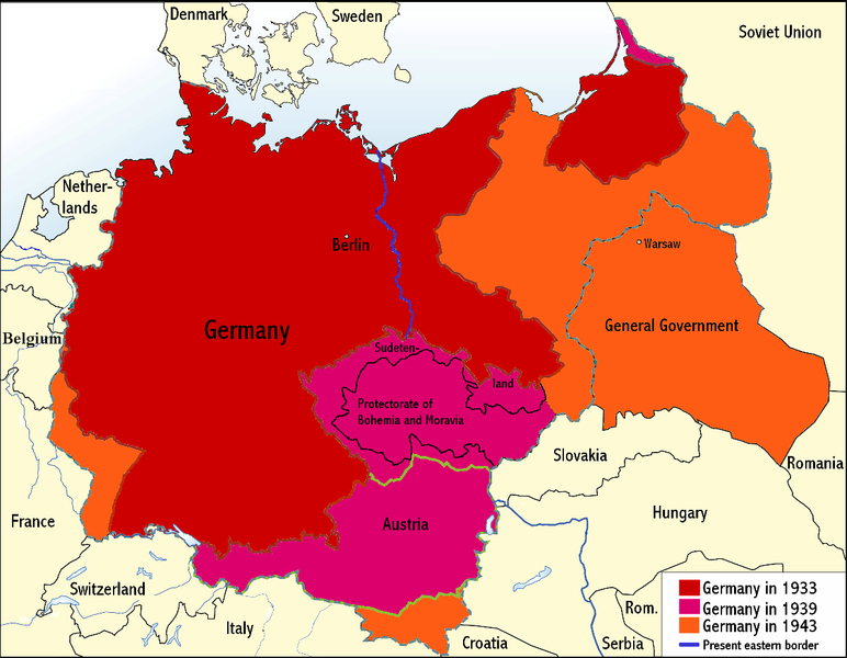
คำอธิบายNazi Germany.png
English: An overview map of Nazi Germany to 1943.
วันที่
แหล่งที่มา
Transferred from the English Wikipedia. Original file is/was here. (Original upload log available below.)
All the following user names refer to the English Wikipedia.
Date/Time
Dimensions
User
Comment
00:03, 24 June 2008
1,200×932 (275 KB)
Wikinist
(Belgia -> Belgium)
00:52, 30 April 2008
1,200×932 (286 KB)
R-41
(Removed swastika from map. The title "Germany" is moved up to the centre of Germany on the map now.)
21:37, 29 April 2008
1,200×932 (291 KB)
Wikinist
(== Description== {{Information |Description=An overview map of Nazi Germany, based on another map[http://en.wikipedia.org/wiki/Image:GDR.png] by [[:de:Benutzer:kgberger|kgberger]]. Placenames replaced with English ones, resolution decreased, a lot of info)
{{BotMoveToCommons|en.wikipedia}} {{Information |Description={{en|An overview map of Nazi Germany, based on another map (en::Image:GDR.png) by kgberger. Placenames replaced with English ones, resolution decreased, a lot
หน้าที่มีภาพนี้
ไม่มีหน้าใดโยงมาที่ภาพนี้
การใช้ไฟล์ส่วนกลาง
วิกิอื่นต่อไปนี้ใช้ไฟล์นี้:
Portal:Alemanha Nazista/Mapa
มกราคม 24, 2023
ไฟล, nazi, germany, ไฟล, ประว, ไฟล, หน, าท, ภาพน, การใช, ไฟล, วนกลางขนาดของต, วอย, างน, กเซล, ความละเอ, ยดอ, กเซล, กเซล, กเซล, กเซล, ภาพท, ความละเอ, ยดส, งกว, 8206, กเซล, ขนาดไฟล, โลไบต, ชน, ดไมม, image, ปภาพหร, อไฟล, เส, ยงน, นฉบ, บอย, คอมมอนส, รายละเอ, ยดด, . ifl prawtiifl hnathimiphaphni karichiflswnklangkhnadkhxngtwxyangni 772 600 phikesl khwamlaexiydxun 309 240 phikesl 618 480 phikesl 989 768 phikesl 1 200 932 phikesl duphaphthimikhwamlaexiydsungkwa 8206 1 200 932 phikesl khnadifl 263 kiolibt chnidimm image png rupphaphhruxiflesiyngni tnchbbxyuthi khxmmxns raylaexiyddanlang epnkhxkhwamthiaesdngphlcak ifltnchbbinkhxmmxns khxmmxnsepnewbistinokhrngkarsahrbekbrwbrwmsuxesri thi khunsamarthchwyid phaphnimiphaphinrupaebbewketxr SVG hakphaph SVG thaihkaraesdngphldikwa hnathiichphaphnikhwrepliynipichphaph SVG aethn File Nazi Germany png File Nazi Germany svg sahrbkhxmulephimetimekiywkbphaphewketxr duthi karepliynipichphaph SVG inkhxmmxnsnxkcaknisamarthduephimetimekiywkb khxmulekiywkbkarrxngrbphaph SVG sahrbsxftaewrmiediywiki id inphasaxunAlemannisch العربية belaruskaya tarashkevica blgarski ব ল catala nohchijn cestina dansk Deutsch Ellhnika English British English Esperanto espanol eesti euskara فارسی suomi francais Frysk galego עברית hrvatski magyar հայերեն Bahasa Indonesia Ido italiano 日本語 ქართული 한국어 lietuviu makedonski മലയ ള Bahasa Melayu norsk bokmal Plattduutsch Nederlands norsk nynorsk norsk occitan polski portugues portugues do Brasil romană russkij sicilianu Scots slovencina slovenscina srpski srpski svenska தம ழ ithy Turkce tatarcha tatarca ukrayinska veneto Tiếng Việt 中文 简体 中文 繁體 khwamyx khaxthibayNazi Germany png English An overview map of Nazi Germany to 1943 wnthi 30 emsayn ph s 2551aehlngthima Transferred from the English Wikipedia Original file is was here Original upload log available below phusrangsrrkh Wikinistkarxnuyat karichiflniihm xnuyatihkhdlxk aeckcayaela hruxddaeprexksarniphayitenguxnikhkhxngsyyaxnuyatexksaresrikhxngknu run 1 2 hruxrunid nbcaknithixxkodymulnithisxftaewresri odyimmiswnidhamaekikh immikhxkhwampkhnaaelapkhlng saenakhxngsyyaxnuyatrwmxyuinswnchux syyaxnuyatexksaresrikhxngknuhttp www gnu org copyleft fdl html GFDL GNU Free Documentation License true trueiflnixyuphayitsyyaxnuyat khriexthifkhxmmxns aebbaesdngthima xnuyataebbediywkn 3 0 tnchbbkhunsamarth thicaaebngpn thicathasaena aeckcay aelasngngandngklawtxip thicaeriyberiyngihm thicaddaeplngngandngklaw phayitenguxnikhtxipni aesdngthima khuntxngihekiyrtiecakhxngnganxyangehmaasm odyephimlingkipyngsyyaxnuyat aelarabuhakmikarepliynaeplng khunxacthaechnniidinrupaebbidkidtamkhwr aettxngimichinlksnathiaenawaphuihxnuyatsnbsnunkhunhruxkarichngankhxngkhun xnuyataebbediywkn hakkhunddaeplng epliynrup hruxtxetimnganni khuntxngichsyyaxnuyataebbediywknhruxaebbthiehmuxnkbsyyaxnuyatthiichkbnganniethannpayaesdngsthanalikhsiththinithukephimephuxihepniptamkarepliynaeplngsyyaxnuyatkhxngmulnithiwikimiediy cak GFDL ipyng GFDL khwbkhukb CC BY SA 3 0 http creativecommons org licenses by sa 3 0 CC BY SA 3 0 Creative Commons Attribution Share Alike 3 0 true trueewxrchnxun iflxunthiichiflni Nazi Germany it svg bnthukkarxphohld All the following user names refer to the English Wikipedia Date Time Dimensions User Comment00 03 24 June 2008 1 200 932 275 KB Wikinist Belgia gt Belgium 00 52 30 April 2008 1 200 932 286 KB R 41 Removed swastika from map The title Germany is moved up to the centre of Germany on the map now 21 37 29 April 2008 1 200 932 291 KB Wikinist Description Information Description An overview map of Nazi Germany based on another map http en wikipedia org wiki Image GDR png by de Benutzer kgberger kgberger Placenames replaced with English ones resolution decreased a lot of info khabrryayodyyxithyephimkhabrryaythrrthdediywephuxkhyaykhwamwaiflnimixairixethmthiaesdngxyuiniflniprakxbdwysthanalikhsiththimilikhsiththisyyaxnuyatCreative Commons Attribution ShareAlike 3 0 Unported xngkvsGNU Free Documentation License version 1 2 or later xngkvswnthisrang wnkxtng30 emsayn 2008 prawtiifl khlikwnthi ewlaephuxduiflthipraktinkhnann wnthi ewlarupyxkhnadphuichkhwamehn pccubn06 35 7 mithunayn 25521 200 932 263 kiolibt MaggotMasterReverted to version as of 22 18 21 May 2009 18 57 4 mithunayn 25521 200 932 234 kiolibt Fz22 commonswiki Information Description Source Date Author Permission other versions 05 18 22 phvsphakhm 25521 200 932 263 kiolibt HohumReduced garish colour intensity 16 30 19 mkrakhm 25521 200 932 207 kiolibt Brianskiclean up the legend 03 20 9 tulakhm 25511 200 932 275 kiolibt File Upload Bot Magnus Manske BotMoveToCommons en wikipedia Information Description en An overview map of Nazi Germany based on another map en Image GDR png by kgberger Placenames replaced with English ones resolution decreased a lot hnathimiphaphni immihnaidoyngmathiphaphnikarichiflswnklang wikixuntxipniichiflni karichbn en wikipedia org Territorial evolution of Germany karichbn la wikipedia org Germania nazistica karichbn pt wikipedia org Portal Alemanha Nazista Portal Alemanha Nazista Mapa ekhathungcak https th wikipedia org wiki ifl Nazi Germany png, wikipedia, วิกิ หนังสือ, หนังสือ, ห้องสมุด,