fixing Ngari/Shigatse prefecture boundary as pointed out by user:Fhah4 [http://en.wikipedia.org/w/index.php?title=Wikipedia:Graphics_Lab/Map_workshop&diff=541288793&oldid=541266575 here]
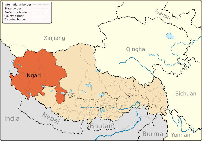
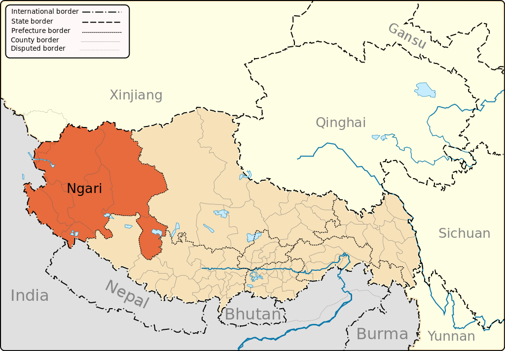
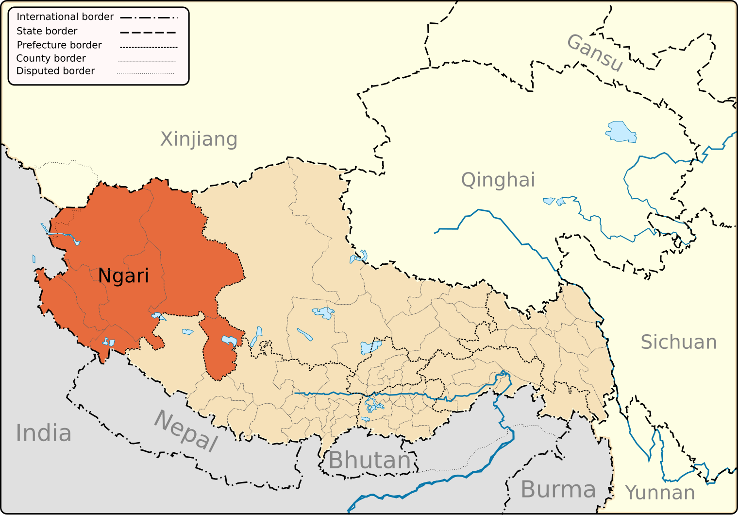
{{Information |Description={{en|1=A map of the administrative boundaries of The Tibetan Autonomous Region with Nari (aka Ali) Prefecture highlighted.}} |Source=Own work by uploader |Author=Keithonearth |Date=2008-12-29 |Permission= |
ไฟล, ngari, ไฟล, ประว, ไฟล, หน, าท, ภาพน, การใช, ไฟล, วนกลาง, อม, ลเก, ยวก, บภาพขนาดของต, วอย, าง, ของไฟล, กเซล, ความละเอ, ยดอ, กเซล, กเซล, กเซล, กเซล, กเซล, กเซล, ภาพท, ความละเอ, ยดส, งกว, 8206, ไฟล, กเซล, ขนาดไฟล, โลไบต, ปภาพหร, อไฟล, เส, ยงน, นฉบ, บอย, คอมม. ifl prawtiifl hnathimiphaphni karichiflswnklang khxmulekiywkbphaphkhnadkhxngtwxyang PNG nikhxngifl SVG ni 800 557 phikesl khwamlaexiydxun 320 223 phikesl 640 446 phikesl 1 024 713 phikesl 1 280 892 phikesl 2 560 1 784 phikesl 1 520 1 059 phikesl duphaphthimikhwamlaexiydsungkwa 8206 ifl SVG 1 520 1 059 phikesl khnadifl 189 kiolibt rupphaphhruxiflesiyngni tnchbbxyuthi khxmmxns raylaexiyddanlang epnkhxkhwamthiaesdngphlcak ifltnchbbinkhxmmxns khxmmxnsepnewbistinokhrngkarsahrbekbrwbrwmsuxesri thi khunsamarthchwyid khwamyx khaxthibayNgari map svg English A map of the administrative boundaries of The Tibet Autonomous Region with Ngari aka Ali Prefecture highlighted wnthi 29 thnwakhm ph s 2551aehlngthima ngankhxngtwphusrangsrrkh Keithonearthewxrchnxun TAR and neighboring Himalayan and Tibetan Plateau regions Lhasa Prefecture highlighted Nagqu aka Nakchu Prefecture highlighted Nyinchi Prefecture highlighted Qamdo aka Chamdo Prefecture highlighted Shigatse aka Xigatse Prefecture highlighted a version for use as a locator mapSVG genesisInfoField sxrsokhdkhxng SVG nitrwcsxbthuktxngaelw iflphaphkrafiksewketxrni srangkhunodyich Inkscape or with something else karxnuyatichsiththi khapheca inthanaphuthuxlikhsiththikhxngphaphhruxsuxni xnuyatihichphaphhruxsuxniphayitenguxnikhtxipniiflnixyuphayitsyyaxnuyat khriexthifkhxmmxns aebbaesdngthima xnuyataebbediywkn 3 0 tnchbbkhunsamarth thicaaebngpn thicathasaena aeckcay aelasngngandngklawtxip thicaeriyberiyngihm thicaddaeplngngandngklaw phayitenguxnikhtxipni aesdngthima khuntxngihekiyrtiecakhxngnganxyangehmaasm odyephimlingkipyngsyyaxnuyat aelarabuhakmikarepliynaeplng khunxacthaechnniidinrupaebbidkidtamkhwr aettxngimichinlksnathiaenawaphuihxnuyatsnbsnunkhunhruxkarichngankhxngkhun xnuyataebbediywkn hakkhunddaeplng epliynrup hruxtxetimnganni khuntxngichsyyaxnuyataebbediywknhruxaebbthiehmuxnkbsyyaxnuyatthiichkbnganniethannhttps creativecommons org licenses by sa 3 0 CC BY SA 3 0 Creative Commons Attribution Share Alike 3 0 true true xnuyatihkhdlxk aeckcayaela hruxddaeprexksarniphayitenguxnikhkhxngsyyaxnuyatexksaresrikhxngknu run 1 2 hruxrunid nbcaknithixxkodymulnithisxftaewresri odyimmiswnidhamaekikh immikhxkhwampkhnaaelapkhlng saenakhxngsyyaxnuyatrwmxyuinswnchux syyaxnuyatexksaresrikhxngknuhttp www gnu org copyleft fdl html GFDL GNU Free Documentation License true truekhunsamartheluxksyyaxnuyatdngklawtamtxngkarkhabrryayodyyxithyephimkhabrryaythrrthdediywephuxkhyaykhwamwaiflnimixairixethmthiaesdngxyuiniflniprakxbdwyphusrangbangkhathiimmiixethmwikisnethschuxphusrangsrrkh Keithonearthchuxphuichwikimiediy Keithonearthyuxaraexl http commons wikimedia org wiki User KeithonearthsthanalikhsiththimilikhsiththisyyaxnuyatGNU Free Documentation License version 1 2 or later xngkvsCreative Commons Attribution ShareAlike 3 0 Unported xngkvswnthisrang wnkxtng29 thnwakhm 2008thimakhxngiflkarsrangdngedimodyphuxpohld prawtiifl khlikwnthi ewlaephuxduiflthipraktinkhnann wnthi ewlarupyxkhnadphuichkhwamehn pccubn03 14 13 minakhm 25561 520 1 059 189 kiolibt Keithonearthfixing Ngari Shigatse prefecture boundary as pointed out by user Fhah4 http en wikipedia org w index php title Wikipedia Graphics Lab Map workshop amp diff 541288793 amp oldid 541266575 here 12 04 31 thnwakhm 25511 520 1 059 212 kiolibt KeithonearthChanging colour scheme to make more sense progression from non highlighted to most highlighted Category Tibet 09 17 30 thnwakhm 25511 520 1 059 212 kiolibt Keithonearth Information Description en 1 A map of the administrative boundaries of The Tibetan Autonomous Region with Nari aka Ali Prefecture highlighted Source Own work by uploader Author Keithonearth Date 2008 12 29 Permission hnathimiphaphni hnatxipni oyngmathiphaphni ngari karichiflswnklang wikixuntxipniichiflni karichbn bn wikipedia org ম ঙ গ র স ব ভ গ karichbn bo wikipedia org མངའ ར ས ས ཁ ལ karichbn cdo wikipedia org Ngari karichbn da wikipedia org Ngari karichbn en wikipedia org Ngari Prefecture Shiquanhe Rutog County Purang County Lumajangdong Co Template Ngari Prefecture Coqen County Gar County Ge gyai County Gertse County Zanda County Purang Town Coqen Town Rutog Town Demchok Ngari Prefecture Tholing Minsar Zoco Tibet Tsaparang Tholing Monastery Ngari Gunsa Airport Tegla Kar Orba Co Zhari Namco Dawa Lake Bangda Lake Guozha Lake Longmu Lake Chepzi Risum Township Tong Tso Wikipedia Graphics Lab Map workshop Archive Mar 2013 Jaggang Tsosib Sumkyil Township karichbn es wikipedia org Ngari karichbn eu wikipedia org Ngari prefektura karichbn fi wikipedia org Ngarin prefektuuri karichbn fr wikipedia org Prefecture de Ngari karichbn hi wikipedia org न ग र व भ ग karichbn it wikipedia org Prefettura di Ngari karichbn it wikivoyage org Prefettura di Ngari karichbn pnb wikipedia org نگاری پریفیکچر karichbn pt wikipedia org Ngari karichbn ru wikipedia org Ngari karichbn sv wikipedia org Ngari karichbn tr wikipedia org Ngari dukarichthwolkephimetimkhxngiflnikhxmulekiywkbphaph phaphnimikhxmulephimetim sungswnihymacakklxngdicitxlhruxsaeknenxrthisamarthekbkhxmuldngklawiwrwmkbphaphid thaphaphnithukprbprungaekikhhruxepliynaeplngcakedim khxmulbangxyangcayngkhngimepliynaeplngehmuxnphaphthithukprbprungaekikhnnkhwamkwang1520 4525khwamsung1059 4189 ekhathungcak https th wikipedia org wiki ifl Ngari map svg, wikipedia, วิกิ หนังสือ, หนังสือ, ห้องสมุด,