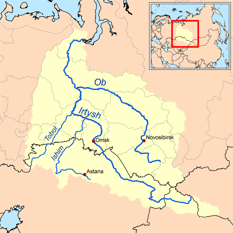
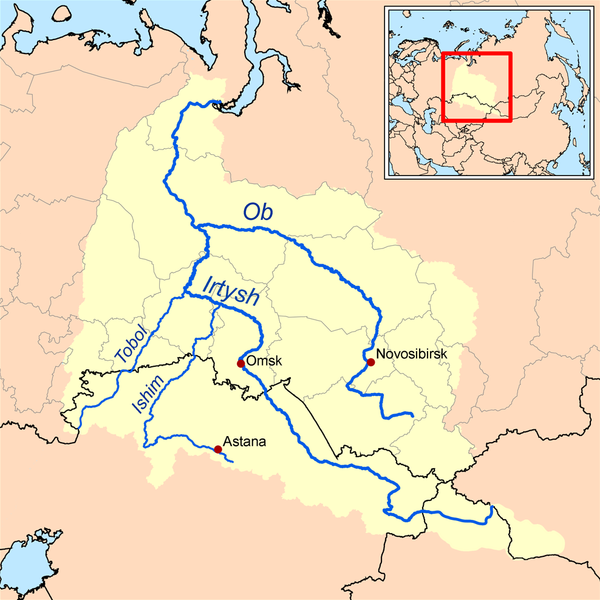
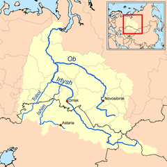
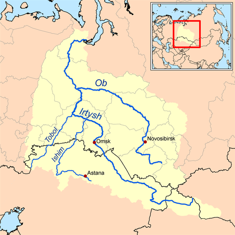
ไฟล, watershed, ไฟล, ประว, ไฟล, หน, าท, ภาพน, การใช, ไฟล, วนกลางขนาดของต, วอย, างน, กเซล, ความละเอ, ยดอ, กเซล, กเซล, กเซล, ภาพท, ความละเอ, ยดส, งกว, 8206, กเซล, ขนาดไฟล, โลไบต, ชน, ดไมม, image, ปภาพหร, อไฟล, เส, ยงน, นฉบ, บอย, คอมมอนส, รายละเอ, ยดด, านล, าง, เ. ifl prawtiifl hnathimiphaphni karichiflswnklangkhnadkhxngtwxyangni 600 600 phikesl khwamlaexiydxun 240 240 phikesl 480 480 phikesl 988 988 phikesl duphaphthimikhwamlaexiydsungkwa 8206 988 988 phikesl khnadifl 295 kiolibt chnidimm image png rupphaphhruxiflesiyngni tnchbbxyuthi khxmmxns raylaexiyddanlang epnkhxkhwamthiaesdngphlcak ifltnchbbinkhxmmxns khxmmxnsepnewbistinokhrngkarsahrbekbrwbrwmsuxesri thi khunsamarthchwyid khwamyx khaxthibayOb watershed png English This is a map of the Ob River Watershed at the confluence with the Irtysh river Created based on USGS data wnthi 10 emsayn ph s 2549aehlngthima ngankhxngtwphusrangsrrkh Karl Musser karxnuyatichsiththi khapheca inthanaphuthuxlikhsiththikhxngphaphhruxsuxni xnuyatihichphaphhruxsuxniphayitenguxnikhtxipniiflnixyuphayitsyyaxnuyat khriexthifkhxmmxns aebbaesdngthima xnuyataebbediywkn 2 5 thwipkhunsamarth thicaaebngpn thicathasaena aeckcay aelasngngandngklawtxip thicaeriyberiyngihm thicaddaeplngngandngklaw phayitenguxnikhtxipni aesdngthima khuntxngihekiyrtiecakhxngnganxyangehmaasm odyephimlingkipyngsyyaxnuyat aelarabuhakmikarepliynaeplng khunxacthaechnniidinrupaebbidkidtamkhwr aettxngimichinlksnathiaenawaphuihxnuyatsnbsnunkhunhruxkarichngankhxngkhun xnuyataebbediywkn hakkhunddaeplng epliynrup hruxtxetimnganni khuntxngichsyyaxnuyataebbediywknhruxaebbthiehmuxnkbsyyaxnuyatthiichkbnganniethannhttps creativecommons org licenses by sa 2 5 CC BY SA 2 5 Creative Commons Attribution Share Alike 2 5 true truekhabrryayodyyxithyephimkhabrryaythrrthdediywephuxkhyaykhwamwaiflnimixairixethmthiaesdngxyuiniflniprakxbdwysthanalikhsiththimilikhsiththisyyaxnuyatCreative Commons Attribution ShareAlike 2 5 Generic xngkvswnthisrang wnkxtng10 emsayn 2006thimakhxngiflkarsrangdngedimodyphuxpohld prawtiifl khlikwnthi ewlaephuxduiflthipraktinkhnann wnthi ewlarupyxkhnadphuichkhwamehn pccubn20 37 26 tulakhm 2556988 988 295 kiolibt Ras67cropped opt 23 36 16 knyayn 25511 000 1 000 380 kiolibt Kmussernew and improved 01 12 11 emsayn 2549300 300 18 kiolibt KmusserThis is a map of the Ob River Watershed I Karl Musser created it based on USGS data GFDL Category Maps of rivers hnathimiphaphni hnatxipni oyngmathiphaphni aemnaxxb karichiflswnklang wikixuntxipniichiflni karichbn af wikipedia org Ob Irtisj Isjim Tobol karichbn ar wikipedia org إيرتيش karichbn ast wikipedia org Janti Mansi Novosibirsk Yamalia Nenetsia Omsk karichbn azb wikipedia org اوب چایی ایشیم چایی karichbn be wikipedia org Ob karichbn bn wikipedia org ইস ম নদ karichbn ca wikipedia org Obi Conquesta del Kanat de Siberia karichbn cs wikipedia org Isim reka Ob karichbn cy wikipedia org Afon Irtysh Afon Ob karichbn da wikipedia org Ob Irtysj karichbn de wikipedia org Ischim Fluss Irtysch Ob Tobol Benutzer W Mechelke WorkinProgress Russland Kamener karichbn el wikipedia org Perifereia Pablontar Potamos Isim Potamos Tompol karichbn en wikipedia org Ishim river List of rivers of China User Kmusser Images Pavlodar Region List of Russian explorers Conquest of the Khanate of Sibir karichbn eo wikipedia org Irtiŝo Tobolo Obo karichbn es wikipedia org Omsk Rio Obi Krai de Altai Rio Irtish oblast de Tiumen oblast de Tomsk Rio Tobol Distrito autonomo de Janti Mansi Distrito autonomo de Yamalia Nenetsia Rio Ishim Rio Chumish Conquista del kanato de Siberia dukarichthwolkephimetimkhxngiflni ekhathungcak https th wikipedia org wiki ifl Ob watershed png, wikipedia, วิกิ หนังสือ, หนังสือ, ห้องสมุด,