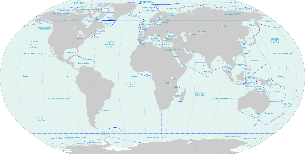
English: World map of oceans and seas : English version
วันที่
(UTC)
แหล่งที่มา
Own work using:
Oceans_and_seas_boundaries_map-fr.svg. From IHO 23-3rd: Limits of Oceans and Seas, Special Publication 23, 3rd Edition 1953, published by the International Hydrographic Organization.
ผู้สร้างสรรค์
Oceans_and_seas_boundaries_map-fr.svg: Pinpin
derivative work: Jugger90 (talk)
derivative work: Dziban303 (คุย) 02:20, 5 April 2021 (UTC)
เวอร์ชันอื่น
Turkish version, French version
ภาพนี้ ได้รับการปรับแต่งภาพ ซึ่งหมายความว่าจะได้รับการเปลี่ยนแปลงภาพต่างจากต้นฉบับ การปรับปรุง: Translated remaining French labels, fixed some English labels, added missing sea and lake names, added missing lake, refactored text styling of some labels to match the rest, fixed rainbow of colors assigned to random islands, added missing Malta and Bermuda islands. ต้นฉบับสามารถดูได้ที่นี่: Oceans and seas boundaries map-en.svg. ปรับแต่งภาพโดย Dziban303.
This image is a derivative work of the following images:
File:Oceans and seas boundaries map-fr.svg licensed with Cc-by-sa-3.0,2.5,2.0,1.0, GFDL
2021-04-05T01:32:50Z Dziban303 2753x1538 (1276318 Bytes) == {{int:filedesc}} == {{Information |Description={{en|World map of oceans and seas : English version}} |Source={{Derived from|Oceans and seas boundaries map-en.svg|display=50}} |Date=2021-04-05 01:09 (UTC) |Author=* [[:File:
English: World map of oceans and seas : English version
|Source={{Derived from|Oceans and seas boundaries map-en.svg|display=50}} |Date=2021-04-04 21:10 (UTC) |Author=* [[:File:
2011-02-13T11:57:29Z Jugger90 2753x1538 (1263323 Bytes) {{Information |Description={{en|World map of oceans and seas : french version}} {{fr|Carte des océans et des mers du monde : version vide}} |Source=*[[:File:Oceans_and_seas_boundaries_map-fr.svg|]] |Date=2011-02-13 11:56 (UT
== {{int:filedesc}} == {{Information |Description={{en|World map of oceans and seas — English version}} |Source={{Derived from|Oceans and seas boundaries map-en.svg|display=50}} |Date=2021-04-05 02:11 (UTC) |Author=* File:Oceans and seas boundaries map-en.svg: *Oceans_and_seas_boundaries_map-fr.svg: Pinpin * derivative work: Jugger90 ([[User talk:Jugger90|<span cla...
== {{int:filedesc}} == {{Information |Description={{en|World map of oceans and seas : English version}} |Source={{Derived from|Oceans and seas boundaries map-en.svg|display=50}} |Date=2021-04-05 01:09 (UTC) |Author=* File:Oceans and seas boundaries map-en.svg: *Oceans_and_seas_boundaries_map-fr.svg: Pinpin *derivative work: Jugger90 ([[User talk:Jugger90|<span clas...
== {{int:filedesc}} == {{Information |Description={{en|World map of oceans and seas : English version}} |Source={{Derived from|Oceans and seas boundaries map-en.svg|display=50}} |Date=2021-04-04 21:10 (UTC) |Author=* File:Oceans and seas boundaries map-en.svg: *Oceans_and_seas_boundaries_map-fr.svg: Pinpin *derivative work: Jugger90 ([[User talk:Jugger90|<span clas...
{{Information |Description={{en|World map of oceans and seas : french version}} {{fr|Carte des océans et des mers du monde : version vide}} |Source=*File:Oceans_and_seas_boundaries_map-fr.svg |Date=2011-02-13 11:56 (UTC) |Author=*[[:File:Oceans_and
ไฟล, oceans, seas, boundaries, ไฟล, ประว, ไฟล, หน, าท, ภาพน, การใช, ไฟล, วนกลาง, อม, ลเก, ยวก, บภาพขนาดของต, วอย, าง, ของไฟล, กเซล, ความละเอ, ยดอ, กเซล, กเซล, กเซล, กเซล, กเซล, กเซล, ภาพท, ความละเอ, ยดส, งกว, 8206, ไฟล, กเซล, ขนาดไฟล, เมกะไบต, ปภาพหร, อไฟล, เส. ifl prawtiifl hnathimiphaphni karichiflswnklang khxmulekiywkbphaphkhnadkhxngtwxyang PNG nikhxngifl SVG ni 800 406 phikesl khwamlaexiydxun 320 162 phikesl 640 325 phikesl 1 024 519 phikesl 1 280 649 phikesl 2 560 1 299 phikesl 4 000 2 029 phikesl duphaphthimikhwamlaexiydsungkwa 8206 ifl SVG 4 000 2 029 phikesl khnadifl 1 39 emkaibt rupphaphhruxiflesiyngni tnchbbxyuthi khxmmxns raylaexiyddanlang epnkhxkhwamthiaesdngphlcak ifltnchbbinkhxmmxns khxmmxnsepnewbistinokhrngkarsahrbekbrwbrwmsuxesri thi khunsamarthchwyid khwamyx khaxthibayOceans and seas boundaries map en svg English World map of oceans and seas English versionwnthi 13 kumphaphnth ph s 2554 11 56 UTC aehlngthima Own work using Oceans and seas boundaries map fr svg From IHO 23 3rd Limits of Oceans and Seas Special Publication 23 3rd Edition 1953 published by the International Hydrographic Organization phusrangsrrkh Oceans and seas boundaries map fr svg Pinpin derivative work Jugger90 talk derivative work Dziban303 khuy 02 20 5 April 2021 UTC ewxrchnxun Turkish version French version phaphni idrbkarprbaetngphaph sunghmaykhwamwacaidrbkarepliynaeplngphaphtangcaktnchbb karprbprung Translated remaining French labels fixed some English labels added missing sea and lake names added missing lake refactored text styling of some labels to match the rest fixed rainbow of colors assigned to random islands added missing Malta and Bermuda islands tnchbbsamarthduidthini Oceans and seas boundaries map en svg prbaetngphaphody Dziban303 khapheca inthanaphuthuxlikhsiththikhxngphaphhruxsuxni xnuyatihichphaphhruxsuxniphayitenguxnikhtxipniiflnixyuphayitsyyaxnuyatkhriexthifkhxmmxns runaesdngthima xnuyataebbediywkn 3 0 tnchbb 2 5 thwip 2 0 thwip aela 1 0 thwipkhunsamarth thicaaebngpn thicathasaena aeckcay aelasngngandngklawtxip thicaeriyberiyngihm thicaddaeplngngandngklaw phayitenguxnikhtxipni aesdngthima khuntxngihekiyrtiecakhxngnganxyangehmaasm odyephimlingkipyngsyyaxnuyat aelarabuhakmikarepliynaeplng khunxacthaechnniidinrupaebbidkidtamkhwr aettxngimichinlksnathiaenawaphuihxnuyatsnbsnunkhunhruxkarichngankhxngkhun xnuyataebbediywkn hakkhunddaeplng epliynrup hruxtxetimnganni khuntxngichsyyaxnuyataebbediywknhruxaebbthiehmuxnkbsyyaxnuyatthiichkbnganniethannhttps creativecommons org licenses by sa 3 0 CC BY SA 3 0 Creative Commons Attribution Share Alike 3 0 true true xnuyatihkhdlxk aeckcayaela hruxddaeprexksarniphayitenguxnikhkhxngsyyaxnuyatexksaresrikhxngknu run 1 2 hruxrunid nbcaknithixxkodymulnithisxftaewresri odyimmiswnidhamaekikh immikhxkhwampkhnaaelapkhlng saenakhxngsyyaxnuyatrwmxyuinswnchux syyaxnuyatexksaresrikhxngknuhttp www gnu org copyleft fdl html GFDL GNU Free Documentation License true truekhunsamartheluxksyyaxnuyatdngklawtamtxngkar bnthukkarxphohld This image is a derivative work of the following images File Oceans and seas boundaries map fr svg licensed with Cc by sa 3 0 2 5 2 0 1 0 GFDL 2021 04 05T01 32 50Z Dziban303 2753x1538 1276318 Bytes int filedesc Information Description en World map of oceans and seas English version Source Derived from Oceans and seas boundaries map en svg display 50 Date 2021 04 05 01 09 UTC Author File 2021 04 04T21 12 48Z Dziban303 2753x1538 1268270 Bytes int filedesc Information Description English World map of oceans and seas English version Source Derived from Oceans and seas boundaries map en svg display 50 Date 2021 04 04 21 10 UTC Author File 2011 02 13T11 57 29Z Jugger90 2753x1538 1263323 Bytes Information Description en World map of oceans and seas french version fr Carte des oceans et des mers du monde version vide Source File Oceans and seas boundaries map fr svg Date 2011 02 13 11 56 UTUploaded with derivativeFXkhabrryayodyyxithyephimkhabrryaythrrthdediywephuxkhyaykhwamwaiflnimixairxngkvsWorld map of oceans and seasixethmthiaesdngxyuiniflniprakxbdwyWorld Ocean xngkvsraychuxthaelsthanalikhsiththimilikhsiththisyyaxnuyatGNU Free Documentation License version 1 2 or later xngkvsCreative Commons Attribution ShareAlike 1 0 Generic xngkvsCreative Commons Attribution ShareAlike 3 0 Unported xngkvsCreative Commons Attribution ShareAlike 2 0 Generic xngkvsCreative Commons Attribution ShareAlike 2 5 Generic xngkvswnthisrang wnkxtng13 kumphaphnth 2011MIME type xngkvsimage svg xml prawtiifl khlikwnthi ewlaephuxduiflthipraktinkhnann wnthi ewlarupyxkhnadphuichkhwamehn pccubn21 11 11 mithunayn 25644 000 2 029 1 39 emkaibt Ibrahim MuizzuddinEdit toponymy resize 20 35 11 mithunayn 25642 753 1 396 1 22 emkaibt Ibrahim MuizzuddinFit image 09 13 5 emsayn 25642 753 1 538 1 22 emkaibt Dziban303 int filedesc Information Description en World map of oceans and seas English version Source Derived from Oceans and seas boundaries map en svg display 50 Date 2021 04 05 02 11 UTC Author File Oceans and seas boundaries map en svg Oceans and seas boundaries map fr svg Pinpin derivative work Jugger90 User talk Jugger90 lt span cla 08 32 5 emsayn 25642 753 1 538 1 22 emkaibt Dziban303 int filedesc Information Description en World map of oceans and seas English version Source Derived from Oceans and seas boundaries map en svg display 50 Date 2021 04 05 01 09 UTC Author File Oceans and seas boundaries map en svg Oceans and seas boundaries map fr svg Pinpin derivative work Jugger90 User talk Jugger90 lt span clas 04 12 5 emsayn 25642 753 1 538 1 21 emkaibt Dziban303 int filedesc Information Description en World map of oceans and seas English version Source Derived from Oceans and seas boundaries map en svg display 50 Date 2021 04 04 21 10 UTC Author File Oceans and seas boundaries map en svg Oceans and seas boundaries map fr svg Pinpin derivative work Jugger90 User talk Jugger90 lt span clas 18 57 13 kumphaphnth 25542 753 1 538 1 2 emkaibt Jugger90 Information Description en World map of oceans and seas french version fr Carte des oceans et des mers du monde version vide Source File Oceans and seas boundaries map fr svg Date 2011 02 13 11 56 UTC Author File Oceans and hnathimiphaphni hnatxipni oyngmathiphaphni raychuxthael karichiflswnklang wikixuntxipniichiflni karichbn ar wikipedia org البحار السبعة karichbn ast wikipedia org Mar marxinal karichbn bh wikipedia org क न र क स गर karichbn blk wikipedia org ပင လယ karichbn bs wikipedia org Rubno more karichbn ceb wikipedia org Kadagatan karichbn da wikipedia org Internationale Hydrografiske Organisation Randhav karichbn de wikipedia org Sudpazifik Wikipedia Loschkandidaten 28 Dezember 2017 karichbn el wikipedia org 8alassa karichbn en wikipedia org Seven Seas List of seas Sea Wikipedia Userboxes Interests 04 karichbn eo wikipedia org Maro Bordomaro karichbn es wikipedia org Mar Mar marginal karichbn fa wikipedia org دریای کرانه ای karichbn fi wikipedia org Luettelo merialueista karichbn ilo wikipedia org Pingir a baybay karichbn it wikipedia org Mare marginale karichbn kn wikipedia org ಸಮ ದ ರ ಮತ ತ ಸ ಗರಗಳ ಪಟ ಟ karichbn mk wikipedia org Rabno more karichbn mr wikipedia org सम द र च य द karichbn ms wikipedia org Laut pinggir karichbn ru wikipedia org More karichbn sh wikipedia org Rubno more karichbn sl wikipedia org Robno morje karichbn sn wikipedia org Udorongodzwa hwe mabhahari karichbn sv wikipedia org Randhav Bihav karichbn ur wikipedia org مختتم بحیرہ karichbn vi wikipedia org Danh sach biển karichbn zh wikipedia org 太平洋 南太平洋khxmulekiywkbphaph phaphnimikhxmulephimetim sungswnihymacakklxngdicitxlhruxsaeknenxrthisamarthekbkhxmuldngklawiwrwmkbphaphid thaphaphnithukprbprungaekikhhruxepliynaeplngcakedim khxmulbangxyangcayngkhngimepliynaeplngehmuxnphaphthithukprbprungaekikhnnkhwamkwang4000 0007khwamsung2028 7821 ekhathungcak https th wikipedia org wiki ifl Oceans and seas boundaries map en svg, wikipedia, วิกิ หนังสือ, หนังสือ, ห้องสมุด,