| | รูปภาพหรือไฟล์เสียงนี้ ต้นฉบับอยู่ที่ คอมมอนส์ รายละเอียดด้านล่าง เป็นข้อความที่แสดงผลจาก ไฟล์ต้นฉบับในคอมมอนส์ คอมมอนส์เป็นเว็บไซต์ในโครงการสำหรับเก็บรวบรวมสื่อเสรี ที่ คุณสามารถช่วยได้ |
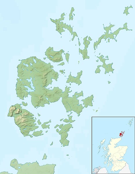
| คำอธิบายOrkney Islands UK relief location map.jpg | Relief map of the Orkney Islands (excluding Sule Stack and Sule Skerry), UK. Equirectangular map projection on WGS 84 datum, with N/S stretched 180% Geographic limits: - West: 3.50W
- East: 2.35W
- North: 59.42N
- South: 58.60N
|
| วันที่ | |
| แหล่งที่มา | Ordnance Survey OpenData. - Relief data from Land-Form Panorama product.
- Administrative borders and coastline data from Boundary-Line product.
- All other geographic data from Meridian 2 product.
- Inset derived from derived from File:Scotland location map.svg by NordNordWest.
|
| ผู้สร้างสรรค์ | Nilfanion, created using Ordnance Survey data |
การอนุญาต
(การใช้ไฟล์นี้ใหม่) |
ไฟล์นี้อยู่ภายใต้สัญญาอนุญาต ครีเอทีฟคอมมอนส์ แบบแสดงที่มา-อนุญาตแบบเดียวกัน 3.0 ต้นฉบับ การแสดงที่มา: Contains Ordnance Survey data © Crown copyright and database right - คุณสามารถ:
- ที่จะแบ่งปัน – ที่จะทำสำเนา แจกจ่าย และส่งงานดังกล่าวต่อไป
- ที่จะเรียบเรียงใหม่ – ที่จะดัดแปลงงานดังกล่าว
- ภายใต้เงื่อนไขต่อไปนี้:
- แสดงที่มา – คุณต้องให้เกียรติเจ้าของงานอย่างเหมาะสม โดยเพิ่มลิงก์ไปยังสัญญาอนุญาต และระบุหากมีการเปลี่ยนแปลง คุณอาจทำเช่นนี้ได้ในรูปแบบใดก็ได้ตามควร แต่ต้องไม่ใช่ในลักษณะที่แนะว่าผู้ให้อนุญาตสนับสนุนคุณหรือการใช้งานของคุณ
- อนุญาตแบบเดียวกัน – หากคุณดัดแปลง เปลี่ยนรูป หรือต่อเติมงานนี้ คุณต้องใช้สัญญาอนุญาตแบบเดียวกันหรือแบบที่เหมือนกับสัญญาอนุญาตที่ใช้กับงานนี้เท่านั้น
https://creativecommons.org/licenses/by-sa/3.0CC BY-SA 3.0 Creative Commons Attribution-Share Alike 3.0 truetrue |
| เวอร์ชันอื่น | File:Orkney Islands UK blank map.svg - Blank map |
เพิ่มคำบรรยายทรรทัดเดียวเพื่อขยายความว่าไฟล์นี้มีอะไร
ประวัติไฟล์
คลิกวันที่/เวลาเพื่อดูไฟล์ที่ปรากฏในขณะนั้น
| วันที่/เวลา | รูปย่อ | ขนาด | ผู้ใช้ | ความเห็น |
|---|
| ปัจจุบัน | 19:26, 30 พฤศจิกายน 2554 | | 2,004 × 2,572 (357 กิโลไบต์) | Nilfanion | {{Information |Description=Relief map of the Orkney Islands (excluding Sule Stack and Sule Skerry), UK. Equirectangular map projection on WGS 84 datum, with N/S stretched 180% Geographic limits: *W |
หน้าที่มีภาพนี้
หน้าต่อไปนี้ โยงมาที่ภาพนี้:
การใช้ไฟล์ส่วนกลาง
วิกิอื่นต่อไปนี้ใช้ไฟล์นี้:
Bootsgrab von Scar Inganess Bay Westray Stone Taversoe Tuick Yetnasteen Sule Stack Blackhammer Broch von Windwick Knowes o’ Trotty Damsay Wideford Hill Cairn Vorlage:Positionskarte Schottland Orkney Benutzer:Metilsteiner/KARTENDIENSTE Loch of Stenness Loch of Harray Souterrain von Windwick Ness of Brodgar Benutzer Diskussion:Thgoiter/Archiv/2013 Gräberfeld von Westness Benutzer Diskussion:Metilsteiner/Archiv/2013/April Muckle Skerry (Orkney) Kili Holm Kirkwall Castle Menhire von Stanerandy Holm of Grimbister Hoy Rousay Brough of Birsay Sanday, Orkney Stronsay Eday Westray Flotta South Ronaldsay Burray Shapinsay Egilsay Wyre, Orkney North Ronaldsay Papa Westray Eynhallow Lamb Holm Auskerry Faray ดูการใช้ทั่วโลกเพิ่มเติมของไฟล์นี้
ไฟล, orkney, islands, relief, location, ไฟล, ประว, ไฟล, หน, าท, ภาพน, การใช, ไฟล, วนกลางขนาดของต, วอย, างน, กเซล, ความละเอ, ยดอ, กเซล, กเซล, กเซล, กเซล, กเซล, ภาพท, ความละเอ, ยดส, งกว, 8206, กเซล, ขนาดไฟล, โลไบต, ชน, ดไมม, image, jpeg, ปภาพหร, อไฟล, เส, ยงน, น. ifl prawtiifl hnathimiphaphni karichiflswnklangkhnadkhxngtwxyangni 467 599 phikesl khwamlaexiydxun 187 240 phikesl 374 480 phikesl 598 768 phikesl 798 1 024 phikesl 2 004 2 572 phikesl duphaphthimikhwamlaexiydsungkwa 8206 2 004 2 572 phikesl khnadifl 357 kiolibt chnidimm image jpeg rupphaphhruxiflesiyngni tnchbbxyuthi khxmmxns raylaexiyddanlang epnkhxkhwamthiaesdngphlcak ifltnchbbinkhxmmxns khxmmxnsepnewbistinokhrngkarsahrbekbrwbrwmsuxesri thi khunsamarthchwyid khaxthibayOrkney Islands UK relief location map jpg Relief map of the Orkney Islands excluding Sule Stack and Sule Skerry UK Equirectangular map projection on WGS 84 datum with N S stretched 180 Geographic limits West 3 50W East 2 35W North 59 42N South 58 60N wnthi 30 phvscikayn ph s 2553 aehlngthima Ordnance Survey OpenData Relief data from Land Form Panorama product Administrative borders and coastline data from Boundary Line product All other geographic data from Meridian 2 product Inset derived from derived from File Scotland location map svg by NordNordWest phusrangsrrkh Nilfanion created using Ordnance Survey data karxnuyat karichiflniihm iflnixyuphayitsyyaxnuyat khriexthifkhxmmxns aebbaesdngthima xnuyataebbediywkn 3 0 tnchbbkaraesdngthima Contains Ordnance Survey data c Crown copyright and database rightkhunsamarth thicaaebngpn thicathasaena aeckcay aelasngngandngklawtxip thicaeriyberiyngihm thicaddaeplngngandngklaw phayitenguxnikhtxipni aesdngthima khuntxngihekiyrtiecakhxngnganxyangehmaasm odyephimlingkipyngsyyaxnuyat aelarabuhakmikarepliynaeplng khunxacthaechnniidinrupaebbidkidtamkhwr aettxngimichinlksnathiaenawaphuihxnuyatsnbsnunkhunhruxkarichngankhxngkhun xnuyataebbediywkn hakkhunddaeplng epliynrup hruxtxetimnganni khuntxngichsyyaxnuyataebbediywknhruxaebbthiehmuxnkbsyyaxnuyatthiichkbnganniethannhttps creativecommons org licenses by sa 3 0 CC BY SA 3 0 Creative Commons Attribution Share Alike 3 0 true true ewxrchnxun File Orkney Islands UK blank map svg Blank mapkhabrryayodyyxithyephimkhabrryaythrrthdediywephuxkhyaykhwamwaiflnimixairixethmthiaesdngxyuiniflniprakxbdwysthanalikhsiththimilikhsiththisyyaxnuyatCreative Commons Attribution ShareAlike 3 0 Unported nbsp xngkvswnthisrang wnkxtng30 phvscikayn 2010 prawtiifl khlikwnthi ewlaephuxduiflthipraktinkhnann wnthi ewlarupyxkhnadphuichkhwamehn pccubn19 26 30 phvscikayn 25542 004 2 572 357 kiolibt Nilfanion Information Description Relief map of the Orkney Islands excluding Sule Stack and Sule Skerry UK Equirectangular map projection on WGS 84 datum with N S stretched 180 Geographic limits W hnathimiphaphni hnatxipni oyngmathiphaphni xxrkniy karichiflswnklang wikixuntxipniichiflni karichbn ar wikipedia org قالب Location map Scotland Orkney karichbn bg wikipedia org Shablon PK Velikobritaniya Orkni karichbn ceb wikipedia org Plantilya Location map Scotland Orkney karichbn de wikipedia org Scapa Flow Bootsgrab von Scar Inganess Bay Westray Stone Taversoe Tuick Yetnasteen Sule Stack Blackhammer Broch von Windwick Knowes o Trotty Damsay Wideford Hill Cairn Vorlage Positionskarte Schottland Orkney Benutzer Metilsteiner KARTENDIENSTE Loch of Stenness Loch of Harray Souterrain von Windwick Ness of Brodgar Benutzer Diskussion Thgoiter Archiv 2013 Graberfeld von Westness Benutzer Diskussion Metilsteiner Archiv 2013 April Muckle Skerry Orkney Kili Holm Kirkwall Castle Menhire von Stanerandy Holm of Grimbister karichbn el wikipedia org Orkades karichbn en wikipedia org Orkney Hoy Rousay Brough of Birsay Sanday Orkney Stronsay Eday Westray Flotta South Ronaldsay Burray Shapinsay Egilsay Wyre Orkney North Ronaldsay Papa Westray Eynhallow Lamb Holm Auskerry Faray dukarichthwolkephimetimkhxngiflni ekhathungcak https th wikipedia org wiki ifl Orkney Islands UK relief location map jpg, wikipedia, วิกิ หนังสือ, หนังสือ, ห้องสมุด,
บทความ
, อ่าน, ดาวน์โหลด, ฟรี, ดาวน์โหลดฟรี, mp3, วิดีโอ, mp4, 3gp, jpg, jpeg, gif, png, รูปภาพ, เพลง, เพลง, หนัง, หนังสือ, เกม, เกม