| | รูปภาพหรือไฟล์เสียงนี้ ต้นฉบับอยู่ที่ คอมมอนส์ รายละเอียดด้านล่าง เป็นข้อความที่แสดงผลจาก ไฟล์ต้นฉบับในคอมมอนส์ คอมมอนส์เป็นเว็บไซต์ในโครงการสำหรับเก็บรวบรวมสื่อเสรี ที่ คุณสามารถช่วยได้ |
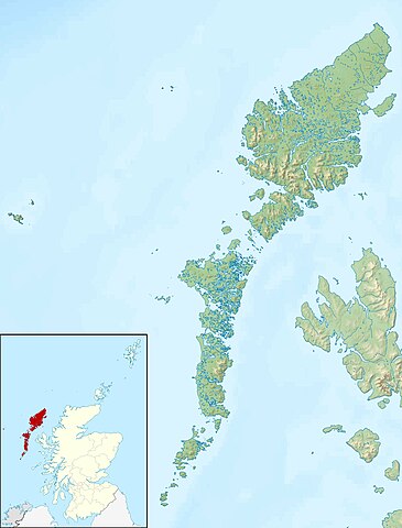
| คำอธิบายOuter Hebrides UK relief location map.jpg | Relief map of the Outer Hebrides (excluding Sula Sgeir), UK. Equirectangular map projection on WGS 84 datum, with N/S stretched 180% Geographic limits: - West: 8.70W
- East: 6.10W
- North: 58.60N
- South: 56.70N
|
| วันที่ | |
| แหล่งที่มา | Ordnance Survey OpenData. - Relief data from Land-Form Panorama product.
- Administrative borders and coastline data from Boundary-Line product.
- All other geographic data from Meridian 2 product.
- Inset derived from derived from File:Scotland location map.svg by NordNordWest.
|
| ผู้สร้างสรรค์ | Nilfanion, created using Ordnance Survey data |
การอนุญาต
(การใช้ไฟล์นี้ใหม่) |
ไฟล์นี้อยู่ภายใต้สัญญาอนุญาต ครีเอทีฟคอมมอนส์ แบบแสดงที่มา-อนุญาตแบบเดียวกัน 3.0 ต้นฉบับ การแสดงที่มา: Contains Ordnance Survey data © Crown copyright and database right - คุณสามารถ:
- ที่จะแบ่งปัน – ที่จะทำสำเนา แจกจ่าย และส่งงานดังกล่าวต่อไป
- ที่จะเรียบเรียงใหม่ – ที่จะดัดแปลงงานดังกล่าว
- ภายใต้เงื่อนไขต่อไปนี้:
- แสดงที่มา – คุณต้องให้เกียรติเจ้าของงานอย่างเหมาะสม โดยเพิ่มลิงก์ไปยังสัญญาอนุญาต และระบุหากมีการเปลี่ยนแปลง คุณอาจทำเช่นนี้ได้ในรูปแบบใดก็ได้ตามควร แต่ต้องไม่ใช่ในลักษณะที่แนะว่าผู้ให้อนุญาตสนับสนุนคุณหรือการใช้งานของคุณ
- อนุญาตแบบเดียวกัน – หากคุณดัดแปลง เปลี่ยนรูป หรือต่อเติมงานนี้ คุณต้องใช้สัญญาอนุญาตแบบเดียวกันหรือแบบที่เหมือนกับสัญญาอนุญาตที่ใช้กับงานนี้เท่านั้น
https://creativecommons.org/licenses/by-sa/3.0CC BY-SA 3.0 Creative Commons Attribution-Share Alike 3.0 truetrue |
| เวอร์ชันอื่น | File:Outer Hebrides UK blank map.svg - Blank map |
เพิ่มคำบรรยายทรรทัดเดียวเพื่อขยายความว่าไฟล์นี้มีอะไร
Relief map of the Outer Hebrides
ประวัติไฟล์
คลิกวันที่/เวลาเพื่อดูไฟล์ที่ปรากฏในขณะนั้น
| วันที่/เวลา | รูปย่อ | ขนาด | ผู้ใช้ | ความเห็น |
|---|
| ปัจจุบัน | 19:26, 30 พฤศจิกายน 2554 | | 2,001 × 2,632 (481 กิโลไบต์) | Nilfanion | {{Information |Description=Relief map of the Outer Hebrides (excluding Sula Sgeir), UK. Equirectangular map projection on WGS 84 datum, with N/S stretched 180% Geographic limits: *West: 8.70W *East: 6.10W *North: 58 |
หน้าที่มีภาพนี้
หน้าต่อไปนี้ โยงมาที่ภาพนี้:
การใช้ไฟล์ส่วนกลาง
วิกิอื่นต่อไปนี้ใช้ไฟล์นี้:
- هبرديس الخارجية
- قائمة جزر المملكة المتحدة
North Uist South Uist Benbecula Barra St Kilda, Scotland Hirta Eriskay Taransay Vatersay Grimsay Scalpay, Outer Hebrides Great Bernera Berneray (North Uist) Baleshare Vallay Scarp, Scotland Mingulay Barra Head Sandray Pabbay, Barra Isles Flannan Isles Soay, St Kilda Ronay Boreray, North Uist Sgeotasaigh Tahay Pabbay, Harris Shillay Seaforth Island Ensay (Outer Hebrides) Muldoanich Stac Lee Grimsay (South East Benbecula) Stac an Armin Gighay Stac Biorach Killegray Fuday Eilean Mhealasta Eilean Chaluim Chille Eilean Chearstaidh Lingeigh ดูการใช้ทั่วโลกเพิ่มเติมของไฟล์นี้
ไฟล, outer, hebrides, relief, location, ไฟล, ประว, ไฟล, หน, าท, ภาพน, การใช, ไฟล, วนกลางขนาดของต, วอย, างน, กเซล, ความละเอ, ยดอ, กเซล, กเซล, กเซล, กเซล, กเซล, ภาพท, ความละเอ, ยดส, งกว, 8206, กเซล, ขนาดไฟล, โลไบต, ชน, ดไมม, image, jpeg, ปภาพหร, อไฟล, เส, ยงน, น. ifl prawtiifl hnathimiphaphni karichiflswnklangkhnadkhxngtwxyangni 456 600 phikesl khwamlaexiydxun 182 240 phikesl 365 480 phikesl 584 768 phikesl 778 1 024 phikesl 2 001 2 632 phikesl duphaphthimikhwamlaexiydsungkwa 8206 2 001 2 632 phikesl khnadifl 481 kiolibt chnidimm image jpeg rupphaphhruxiflesiyngni tnchbbxyuthi khxmmxns raylaexiyddanlang epnkhxkhwamthiaesdngphlcak ifltnchbbinkhxmmxns khxmmxnsepnewbistinokhrngkarsahrbekbrwbrwmsuxesri thi khunsamarthchwyid khaxthibayOuter Hebrides UK relief location map jpg Relief map of the Outer Hebrides excluding Sula Sgeir UK Equirectangular map projection on WGS 84 datum with N S stretched 180 Geographic limits West 8 70W East 6 10W North 58 60N South 56 70Nwnthi 30 phvscikayn ph s 2553aehlngthima Ordnance Survey OpenData Relief data from Land Form Panorama product Administrative borders and coastline data from Boundary Line product All other geographic data from Meridian 2 product Inset derived from derived from File Scotland location map svg by NordNordWest phusrangsrrkh Nilfanion created using Ordnance Survey datakarxnuyat karichiflniihm iflnixyuphayitsyyaxnuyat khriexthifkhxmmxns aebbaesdngthima xnuyataebbediywkn 3 0 tnchbbkaraesdngthima Contains Ordnance Survey data c Crown copyright and database rightkhunsamarth thicaaebngpn thicathasaena aeckcay aelasngngandngklawtxip thicaeriyberiyngihm thicaddaeplngngandngklaw phayitenguxnikhtxipni aesdngthima khuntxngihekiyrtiecakhxngnganxyangehmaasm odyephimlingkipyngsyyaxnuyat aelarabuhakmikarepliynaeplng khunxacthaechnniidinrupaebbidkidtamkhwr aettxngimichinlksnathiaenawaphuihxnuyatsnbsnunkhunhruxkarichngankhxngkhun xnuyataebbediywkn hakkhunddaeplng epliynrup hruxtxetimnganni khuntxngichsyyaxnuyataebbediywknhruxaebbthiehmuxnkbsyyaxnuyatthiichkbnganniethannhttps creativecommons org licenses by sa 3 0 CC BY SA 3 0 Creative Commons Attribution Share Alike 3 0 true trueewxrchnxun File Outer Hebrides UK blank map svg Blank mapkhabrryayodyyxithyephimkhabrryaythrrthdediywephuxkhyaykhwamwaiflnimixairxngkvsRelief map of the Outer HebridesixethmthiaesdngxyuiniflniprakxbdwyexaetxrehbridissthanalikhsiththimilikhsiththisyyaxnuyatCreative Commons Attribution ShareAlike 3 0 Unported xngkvswnthisrang wnkxtng30 phvscikayn 2010 prawtiifl khlikwnthi ewlaephuxduiflthipraktinkhnann wnthi ewlarupyxkhnadphuichkhwamehn pccubn19 26 30 phvscikayn 25542 001 2 632 481 kiolibt Nilfanion Information Description Relief map of the Outer Hebrides excluding Sula Sgeir UK Equirectangular map projection on WGS 84 datum with N S stretched 180 Geographic limits West 8 70W East 6 10W North 58 hnathimiphaphni hnatxipni oyngmathiphaphni exaetxrehbridis karichiflswnklang wikixuntxipniichiflni karichbn ar wikipedia org قالب Location map Scotland Outer Hebrides هبرديس الخارجية قائمة جزر المملكة المتحدة karichbn bg wikipedia org Shablon PK Velikobritaniya Vnshni Hebridi karichbn ceb wikipedia org Plantilya Location map Scotland Outer Hebrides karichbn da wikipedia org Ydre Hebrider karichbn de wikipedia org Vorlage Positionskarte Schottland Outer Hebrides karichbn en wikipedia org Outer Hebrides North Uist South Uist Benbecula Barra St Kilda Scotland Hirta Eriskay Taransay Vatersay Grimsay Scalpay Outer Hebrides Great Bernera Berneray North Uist Baleshare Vallay Scarp Scotland Mingulay Barra Head Sandray Pabbay Barra Isles Flannan Isles Soay St Kilda Ronay Boreray North Uist Sgeotasaigh Tahay Pabbay Harris Shillay Seaforth Island Ensay Outer Hebrides Muldoanich Stac Lee Grimsay South East Benbecula Stac an Armin Gighay Stac Biorach Killegray Fuday Eilean Mhealasta Eilean Chaluim Chille Eilean Chearstaidh Lingeigh dukarichthwolkephimetimkhxngiflni ekhathungcak https th wikipedia org wiki ifl Outer Hebrides UK relief location map jpg, wikipedia, วิกิ หนังสือ, หนังสือ, ห้องสมุด,
บทความ
, อ่าน, ดาวน์โหลด, ฟรี, ดาวน์โหลดฟรี, mp3, วิดีโอ, mp4, 3gp, jpg, jpeg, gif, png, รูปภาพ, เพลง, เพลง, หนัง, หนังสือ, เกม, เกม