ภาพแผนที่ทางประวัติศาสตร์นี้ ควรจะถูกสร้างใหม่เป็นกราฟิกส์เวกเตอร์ ซึ่งมีข้อดีอีกหลายประการ ดูเพิ่มเติมที่คอมมอนส์:สื่อต้องการเก็บกวาดสำหรับสารสนเทศเพิ่มเติม หากภาพนี้มีในรูปแบบกราฟิกส์เวกเตอร์อยู่แล้ว กรุณาอัปโหลดและแทนที่แม่แบบนี้ด้วย {{vector version available|ชื่อภาพใหม่}} แนะนำเป็นอย่างยิ่งให้ตั้งชื่อไฟล์เวกเตอร์ใหม่นั้นในรูปแบบ "Persia 600ad.svg" แล้วใส่แม่แบบ Vector version available (หรือ Vva) ซึ่งไม่ต้องใช้พารามิเตอร์ ชื่อภาพใหม่
This historical map image was uploaded in the JPEG format even though it consists of non-photographic data. This information could be stored more efficiently or accurately in the PNG or SVG format. If possible, please upload a PNG or SVG version of this image without compression artifacts, derived from a non-JPEG source (or with existing artifacts removed). After doing so, please tag the JPEG version with {{Superseded|NewImage.ext}} and remove this tag. This tag should not be applied to photographs or scans. For more information, see {{BadJPEG}}.
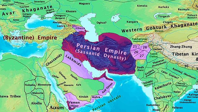
This map is a zoomed-in version of Thomas Lessman's map of the East-Hem_600ad.jpg (also available at www.WorldHistoryMaps.info).
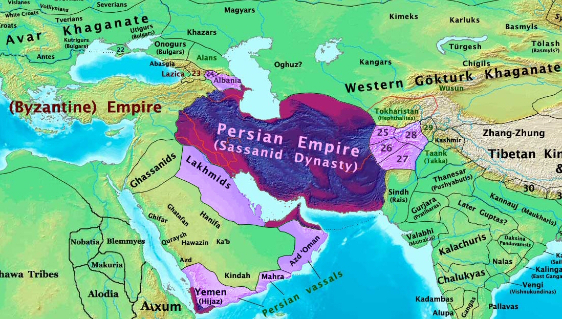
The highlighted areas represent the Persian Sassanid Empire and its territories in the year 600 AD (before the Great Romano-Persian war).
Map Source References
Remember, sources often conflict with each other. This map is only as accurate as the information that is available to me. To report any errors or to help further this work, please click here, or email Thomas Lessman at talessman@yis.us
References for information contained in this map:
See the source info for East-Hem_600ad.jpg
Other Maps by Thomas Lessman
Maps of the eastern hemisphere showing history
Bold dates are available on Wikimedia or Wikipedia. (Other dates are available on www.WorldHistoryMaps.info.) See also: * Disclaimers * Report Errors * Gallery of Maps
Primeval
·| 1300 BC | 1000 BC | 625 BC |
Ancient
BC / BCE
AD / CE
·| 600 BC | 550 BC | 527 BC | 500 BC | 400 BC | ·| 335 BC | 323 BC | 300 BC | 200 BC | ·| 100 BC | 50 BC |
·| 1 AD | 50 AD | 100 AD | 200 AD | 300 AD | ·| 400 AD | 475 AD | 476 AD | 477 AD | ·| 480 AD | 486 AD|
Medieval
·| 500 AD | 565 AD | 600 AD | 700 AD | · | 800 AD | 900 AD | 1025 AD | ·| 1100 AD | 1200 AD | 1300 AD | 1400 AD |
Modern
·| 1500 AD |·* For historical maps of the whole world, see Wikimedia's Template:Maps of world history.
history links talk edit view
Other Info
บันทึกการอัพโหลด
The original description page was here. All following user names refer to en.wikipedia.
2008-01-30 00:27 Talessman 1724×814×8 (267093 bytes) This image is a zoomed-in version of [http://en.wikipedia.org/wiki/Image:East-Hem_600ad.jpg Eastern Hemisphere in 600 AD]. The highlighted area is the Persian Sassanid Empire. [[Image:East-Hem_600ad.jpg|thumb|300px|left|Eastern Hemisphere in 600 AD.]] Author: T
{{Information |Description={{en|This image is a zoomed-in version of [http://en.wikipedia.org/wiki/Image:East-Hem_600ad.jpg Eastern Hemisphere in 600 AD]. The highlighted area is the Sassanid Persian Empire. [[:en:Image:East-Hem_600ad.jpg|thumb|300px|lef
ไฟล, persia, 600ad, ไฟล, ประว, ไฟล, หน, าท, ภาพน, การใช, ไฟล, วนกลางขนาดของต, วอย, างน, กเซล, ความละเอ, ยดอ, กเซล, กเซล, กเซล, ภาพท, ความละเอ, ยดส, งกว, 8206, กเซล, ขนาดไฟล, โลไบต, ชน, ดไมม, image, jpeg, ปภาพหร, อไฟล, เส, ยงน, นฉบ, บอย, คอมมอนส, รายละเอ, ยดด, . ifl prawtiifl hnathimiphaphni karichiflswnklangkhnadkhxngtwxyangni 800 454 phikesl khwamlaexiydxun 320 182 phikesl 640 363 phikesl 1 098 623 phikesl duphaphthimikhwamlaexiydsungkwa 8206 1 098 623 phikesl khnadifl 644 kiolibt chnidimm image jpeg rupphaphhruxiflesiyngni tnchbbxyuthi khxmmxns raylaexiyddanlang epnkhxkhwamthiaesdngphlcak ifltnchbbinkhxmmxns khxmmxnsepnewbistinokhrngkarsahrbekbrwbrwmsuxesri thi khunsamarthchwyid phaphaephnthithangprawtisastrni khwrcathuksrangihmepnkrafiksewketxr sungmikhxdixikhlayprakar duephimetimthikhxmmxns suxtxngkarekbkwadsahrbsarsnethsephimetim hakphaphnimiinrupaebbkrafiksewketxrxyuaelw krunaxpohldaelaaethnthiaemaebbnidwy vector version available i chuxphaphihm i aenanaepnxyangyingihtngchuxiflewketxrihmnninrupaebb Persia 600ad svg aelwisaemaebb Vector version available hrux Vva sungimtxngichpharamietxr chuxphaphihmThis historical map image was uploaded in the JPEG format even though it consists of non photographic data This information could be stored more efficiently or accurately in the PNG or SVG format If possible please upload a PNG or SVG version of this image without compression artifacts derived from a non JPEG source or with existing artifacts removed After doing so please tag the JPEG version with Superseded NewImage ext and remove this tag This tag should not be applied to photographs or scans For more information see BadJPEG enuxha 1 khwamyx 2 Map Summary 3 Map Source References 4 Other Maps by Thomas Lessman 5 Other Info 6 bnthukkarxphohld khwamyx khaxthibayPersia 600ad jpg The Persian Sassanid Empire in 600 AD wnthi 30 mkrakhm ph s 2551aehlngthima ngankhxngtwphusrangsrrkh Thomas Lessman Contact karxnuyat karichiflniihm khapheca inthanaphuthuxlikhsiththikhxngphaphhruxsuxni xnuyatihichphaphhruxsuxniphayitenguxnikhtxipniiflnixyuphayitsyyaxnuyat khriexthifkhxmmxns aebbaesdngthima xnuyataebbediywkn 3 0 tnchbbkhunsamarth thicaaebngpn thicathasaena aeckcay aelasngngandngklawtxip thicaeriyberiyngihm thicaddaeplngngandngklaw phayitenguxnikhtxipni aesdngthima khuntxngihekiyrtiecakhxngnganxyangehmaasm odyephimlingkipyngsyyaxnuyat aelarabuhakmikarepliynaeplng khunxacthaechnniidinrupaebbidkidtamkhwr aettxngimichinlksnathiaenawaphuihxnuyatsnbsnunkhunhruxkarichngankhxngkhun xnuyataebbediywkn hakkhunddaeplng epliynrup hruxtxetimnganni khuntxngichsyyaxnuyataebbediywknhruxaebbthiehmuxnkbsyyaxnuyatthiichkbnganniethannhttps creativecommons org licenses by sa 3 0 CC BY SA 3 0 Creative Commons Attribution Share Alike 3 0 true trueewxrchnxun see below Map Summary Full map Eastern Hemisphere in 600 AD Original Source URL http www thomaslessman com History images East Hem 600ad jpg This map is a zoomed in version of Thomas Lessman s map of the East Hem 600ad jpg also available at www WorldHistoryMaps info The highlighted areas represent the Persian Sassanid Empire and its territories in the year 600 AD before the Great Romano Persian war Map Source References Remember sources often conflict with each other This map is only as accurate as the information that is available to me To report any errors or to help further this work please click here or email Thomas Lessman at talessman yis usReferences for information contained in this map See the source info for East Hem 600ad jpg Other Maps by Thomas Lessman Maps of the eastern hemisphere showing history Bold dates are available on Wikimedia or Wikipedia Other dates are available on www WorldHistoryMaps info See also Disclaimers Report Errors Gallery of MapsPrimeval 1300 BC 1000 BC 625 BC Ancient BC BCEAD CE 600 BC 550 BC 527 BC 500 BC 400 BC 335 BC 323 BC 300 BC 200 BC 100 BC 50 BC 1 AD 50 AD 100 AD 200 AD 300 AD 400 AD 475 AD 476 AD 477 AD 480 AD 486 AD Medieval 500 AD 565 AD 600 AD 700 AD 800 AD 900 AD 1025 AD 1100 AD 1200 AD 1300 AD 1400 AD Modern 1500 AD For historical maps of the whole world see Wikimedia s Template Maps of world history history links talk edit view Other Info bnthukkarxphohld The original description page was here All following user names refer to en wikipedia 2008 01 30 00 27 Talessman 1724 814 8 267093 bytes This image is a zoomed in version of http en wikipedia org wiki Image East Hem 600ad jpg Eastern Hemisphere in 600 AD The highlighted area is the Persian Sassanid Empire Image East Hem 600ad jpg thumb 300px left Eastern Hemisphere in 600 AD Author Tkhabrryayodyyxithyephimkhabrryaythrrthdediywephuxkhyaykhwamwaiflnimixairixethmthiaesdngxyuiniflniprakxbdwyphusrangbangkhathiimmiixethmwikisnethschuxphuichwikimiediy Talessmanyuxaraexl https commons wikimedia org wiki user Talessmanchuxphusrangsrrkh Thomas LessmansthanalikhsiththimilikhsiththisyyaxnuyatCreative Commons Attribution ShareAlike 3 0 Unported xngkvswnthisrang wnkxtng30 mkrakhm 2008thimakhxngiflkarsrangdngedimodyphuxpohld prawtiifl khlikwnthi ewlaephuxduiflthipraktinkhnann wnthi ewlarupyxkhnadphuichkhwamehn pccubn02 44 8 thnwakhm 25581 098 623 644 kiolibt BRemoved obnoxious label 04 00 22 singhakhm 25511 098 623 813 kiolibt TalessmanUpdated version of the parent map This new version features colored areas to highlight the Persian Empire and its vassal states 00 25 29 emsayn 25511 724 814 261 kiolibt Producer Information Description en This image is a zoomed in version of http en wikipedia org wiki Image East Hem 600ad jpg Eastern Hemisphere in 600 AD The highlighted area is the Sassanid Persian Empire en Image East Hem 600ad jpg thumb 300px lef hnathimiphaphni hnatxipni oyngmathiphaphni prawtisastrbahern karichiflswnklang wikixuntxipniichiflni karichbn ar wikipedia org تاريخ الإمارات العربية المتحدة تايلوس karichbn as wikipedia org ম হ ম ম দ karichbn azb wikipedia org فارس و روم ساواشلاری بیزانس ساسانی ساواشلاری karichbn bn wikipedia org ম হ ম ম দ karichbn ca wikipedia org Historia d Oman karichbn cs wikipedia org Rimsko perske valky karichbn el wikipedia org Tylos karichbn en wikipedia org Tylos Roman Persian Wars Pre Islamic Arabia Eastern Arabia User Talessman Maps Bahrain User John K Persian Empire Portal Bahrain User Falcaorib User Nar 2608 sandbox South Azerbaijan karichbn es wikipedia org Historia de Barein Tylos Historia de Oman karichbn fa wikipedia org لخمیان جنگ ذوقار نعمان سوم ایاس بن طایی تاریخ بحرین karichbn fr wikipedia org Histoire de la Syrie Histoire de l Arabie saoudite Histoire de l Irak Ghassanides Lakhmides Histoire de la Jordanie Litterature irakienne karichbn hi wikipedia org फ रस स म र ज य karichbn hy wikipedia org Հռոմեա պարսկական պատերազմներ karichbn hyw wikipedia org Հռոմէա պարսկական Պատերազմներ karichbn id wikipedia org Perang Romawi Persia Tylos karichbn incubator wikimedia org Wp abv البحرين karichbn is wikipedia org Sassanidar karichbn it wikipedia org Guerre romano persiane Armenia provincia romana Guerre romano sasanidi 363 628 Discussione Al Nu man ibn al Mundhir ibn Ma al Sama Battaglia di Dhu Qar karichbn ja wikipedia org サーサーン朝 karichbn ka wikipedia org რომაულ სპარსული ომები karichbn kn wikipedia org ಬಹರ ನ karichbn ko wikipedia org 로마 페르시아 전쟁 dukarichthwolkephimetimkhxngiflni ekhathungcak https th wikipedia org wiki ifl Persia 600ad jpg, wikipedia, วิกิ หนังสือ, หนังสือ, ห้องสมุด,