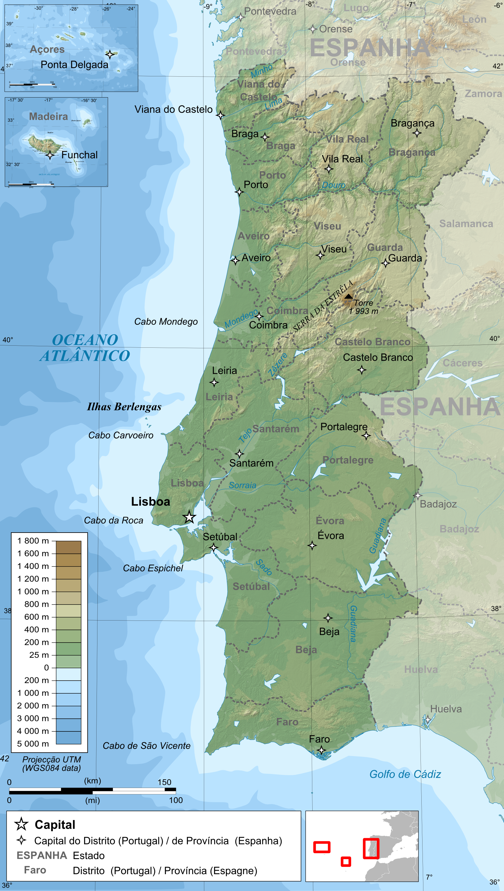
Français : Carte topographique et administrative en portugais du Portugal
Português: Carta topográfica e da administração do Portugal, em português
Deutsch: Topographische Karte von Portugal, portugiesische Version
English: Topographic and administrative map in Portuguese of Portugal
Español: Mapa topográfico y administrativo en portugés del Portugal
Italiano: Carta topografica e amministrativa de Portogallo
日本語: ポルトガル語で表示したポルトガル地形·行政地図
วันที่
แหล่งที่มา
English: Own work ;
Topographic data from the NASA Shuttle Radar Topography Mission (SRTM3 v.2) (public domain) edited with 3DEM, vectorized with Inkscape ; UTM projection ; WGS84 datum ; shaded relief (image of N-W lightning position) ;
Borders, coast, rivers : NGDC GSHHS (Global Self-consistent, Hierarchical, High-resolution Shoreline Database) / World data bank II
Bathymetry : NGDC ETOPO1 ;
Cities, railways, roads : Demis add-on for World Wind (see the approval e-mail and the Demis forum) ;
Note : The shaded relief is a raster image embedded in the SVG file.
Français : Création personnelle ;
Données topographiques de la NASA Shuttle Radar Topography Mission (SRTM3 v.2) (domaine public) éditées avec 3DEM, et vectorisées avec Inkscape ; projection UTM ; WGS84 datum ; relief ombré (image d'éclairage du N-O) ;
Côtes, frontières, fleuves : NGDC GSHHS (Global Self-consistent, Hierarchical, High-resolution Shoreline Database) / World data bank II
Bathymétrie : fichiers ETOPO1 de la National Geophysisal Data Center ;
Villes, chemins de fers, routes : Demis add-on for World Wind (cf. l'e-mail d'approbation de Demis et le Demis forum) ;
Note : Le relief ombré est une image bitmap embarquée dans le fichier SVG et édité avec The Gimp.
This map was improved or created by the Wikigraphists of the Graphic Lab (fr). You can propose images to clean up, improve, create or translate as well.
{{Information |Description= {{fr|Carte topographique et administrative en portugais du Portugal}} {{pt|Carta topográfica e da administração do Portugal, em português}} {{de|Topographische Karte von [[:de:Portugal|Port
ไฟล, portugal, topographic, ไฟล, ประว, ไฟล, หน, าท, ภาพน, การใช, ไฟล, วนกลางขนาดของต, วอย, างน, กเซล, ความละเอ, ยดอ, กเซล, กเซล, กเซล, กเซล, กเซล, ภาพท, ความละเอ, ยดส, งกว, 8206, กเซล, ขนาดไฟล, เมกะไบต, ชน, ดไมม, image, ปภาพหร, อไฟล, เส, ยงน, นฉบ, บอย, คอมมอนส. ifl prawtiifl hnathimiphaphni karichiflswnklangkhnadkhxngtwxyangni 339 599 phikesl khwamlaexiydxun 136 240 phikesl 272 480 phikesl 435 768 phikesl 579 1 024 phikesl 1 738 3 070 phikesl duphaphthimikhwamlaexiydsungkwa 8206 1 738 3 070 phikesl khnadifl 4 6 emkaibt chnidimm image png rupphaphhruxiflesiyngni tnchbbxyuthi khxmmxns raylaexiyddanlang epnkhxkhwamthiaesdngphlcak ifltnchbbinkhxmmxns khxmmxnsepnewbistinokhrngkarsahrbekbrwbrwmsuxesri thi khunsamarthchwyid khaxthibayPortugal topographic map pt png Francais nbsp Carte topographique et administrative en portugais du Portugal Portugues Carta topografica e da administracao do Portugal em portugues Deutsch Topographische Karte von Portugal portugiesische VersionEnglish Topographic and administrative map in Portuguese of PortugalEspanol Mapa topografico y administrativo en portuges del PortugalItaliano Carta topografica e amministrativa de Portogallo日本語 ポルトガル語で表示したポルトガル地形 行政地図 wnthi 14 mithunayn ph s 2552 aehlngthima English Own work nbsp Topographic data from the NASA Shuttle Radar Topography Mission SRTM3 v 2 public domain edited with 3DEM vectorized with Inkscape nbsp UTM projection nbsp WGS84 datum nbsp shaded relief image of N W lightning position nbsp Borders coast rivers nbsp NGDC GSHHS Global Self consistent Hierarchical High resolution Shoreline Database World data bank II Bathymetry nbsp NGDC ETOPO1 nbsp Cities railways roads nbsp Demis add on for World Wind see the approval e mail and the Demis forum nbsp Note nbsp The shaded relief is a raster image embedded in the SVG file Francais nbsp Creation personnelle nbsp Donnees topographiques de la NASA Shuttle Radar Topography Mission SRTM3 v 2 domaine public editees avec 3DEM et vectorisees avec Inkscape nbsp projection UTM nbsp WGS84 datum nbsp relief ombre image d eclairage du N O nbsp Cotes frontieres fleuves nbsp NGDC GSHHS Global Self consistent Hierarchical High resolution Shoreline Database World data bank II Bathymetrie nbsp fichiers ETOPO1 de la National Geophysisal Data Center nbsp Villes chemins de fers routes nbsp Demis add on for World Wind cf l e mail d approbation de Demis et le Demis forum nbsp Note nbsp Le relief ombre est une image bitmap embarquee dans le fichier SVG et edite avec The Gimp phusrangsrrkh Bourrichon fr Bourrichon karxnuyat karichiflniihm khapheca inthanaphuthuxlikhsiththikhxngphaphhruxsuxni xnuyatihichphaphhruxsuxniphayitenguxnikhtxipni xnuyatihkhdlxk aeckcayaela hruxddaeprexksarniphayitenguxnikhkhxngsyyaxnuyatexksaresrikhxngknu run 1 2 hruxrunid nbcaknithixxkodymulnithisxftaewresri odyimmiswnidhamaekikh immikhxkhwampkhnaaelapkhlng saenakhxngsyyaxnuyatrwmxyuinswnchux syyaxnuyatexksaresrikhxngknuhttp www gnu org copyleft fdl html GFDL GNU Free Documentation License true trueiflnixyuphayitsyyaxnuyatkhriexthifkhxmmxns runaesdngthima xnuyataebbediywkn 3 0 tnchbb 2 5 thwip 2 0 thwip aela 1 0 thwipkhunsamarth thicaaebngpn thicathasaena aeckcay aelasngngandngklawtxip thicaeriyberiyngihm thicaddaeplngngandngklaw phayitenguxnikhtxipni aesdngthima khuntxngihekiyrtiecakhxngnganxyangehmaasm odyephimlingkipyngsyyaxnuyat aelarabuhakmikarepliynaeplng khunxacthaechnniidinrupaebbidkidtamkhwr aettxngimichinlksnathiaenawaphuihxnuyatsnbsnunkhunhruxkarichngankhxngkhun xnuyataebbediywkn hakkhunddaeplng epliynrup hruxtxetimnganni khuntxngichsyyaxnuyataebbediywknhruxaebbthiehmuxnkbsyyaxnuyatthiichkbnganniethannhttps creativecommons org licenses by sa 3 0 CC BY SA 3 0 Creative Commons Attribution Share Alike 3 0 true truekhunsamartheluxksyyaxnuyatdngklawtamtxngkar ewxrchnxun svg original blank raster pt svg This map was improved or created by the Wikigraphists of the Graphic Lab fr nbsp You can propose images to clean up improve create or translate as well khabrryayodyyxithyephimkhabrryaythrrthdediywephuxkhyaykhwamwaiflnimixairixethmthiaesdngxyuiniflniprakxbdwysthanalikhsiththimilikhsiththisyyaxnuyatGNU Free Documentation License version 1 2 or later nbsp xngkvsCreative Commons Attribution ShareAlike 2 5 Generic nbsp xngkvsCreative Commons Attribution ShareAlike 2 0 Generic nbsp xngkvsCreative Commons Attribution ShareAlike 1 0 Generic nbsp xngkvsCreative Commons Attribution ShareAlike 3 0 Unported nbsp xngkvswnthisrang wnkxtng14 mithunayn 2009 prawtiifl khlikwnthi ewlaephuxduiflthipraktinkhnann wnthi ewlarupyxkhnadphuichkhwamehn pccubn03 51 15 mithunayn 25521 738 3 070 4 6 emkaibt Bourrichon Information Description fr Carte topographique et administrative en portugais du Portugal pt Carta topografica e da administracao do Portugal em portugues de Topographische Karte von de Portugal Port hnathimiphaphni hnatxipni oyngmathiphaphni 1 E 10 m karichiflswnklang wikixuntxipniichiflni karichbn bxr wikipedia org Portugal karichbn de wikipedia org Benutzer Ulflulfl Karten karichbn el wikipedia org Portogalia karichbn en wikipedia org Portugal Convoy HG 76 karichbn en wikiversity org Continental shelves West European karichbn fr wikipedia org Wikipedia Atelier graphique Cartes Archives avril 2009 karichbn hr wiktionary org Portugal karichbn ilo wikipedia org Portugal karichbn ja wikipedia org ポルトガル karichbn kn wikipedia org ಪ ರ ಚ ಗಲ karichbn ko wikipedia org 포르투갈 karichbn la wiktionary org Portugallia karichbn lez wikipedia org Kilin chchin Portugaliya Vikipediya Hkyagaj makala Shablon Kilin chchin featured article karichbn mn wikipedia org Portugal karichbn ps wikipedia org پرتګال karichbn pt wikipedia org Portugal karichbn ro wikipedia org Portugalia karichbn sd wikipedia org پورچوگال karichbn sl wikipedia org Portugalska karichbn test2 wikipedia org Portugal karichbn te wikipedia org ప ర చ గల karichbn tr wikipedia org Portekiz karichbn vi wikipedia org Bồ Đao Nha karichbn zh wikipedia org 葡萄牙 ekhathungcak https th wikipedia org wiki ifl Portugal topographic map pt png, wikipedia, วิกิ หนังสือ, หนังสือ, ห้องสมุด,