English: Qeshm Island in the Strait of Hormuz, Iran. This image is a combination of two images acquired by the Enhanced Thematic Mapper on NASA’s Landsat 7 satellite
فارسی: تصویر ماهوارهای از جزیرهٔ قشم در تنگهٔ هرمز
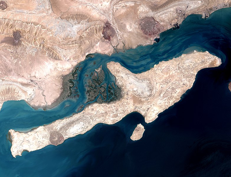
English: Qeshm Island in the Strait of Hormuz, Iran. This image is a combination of two images acquired by the Enhanced Thematic Mapper on NASA’s Landsat 7 satellite.
ภาษาอื่น ๆ:
English: Qeshm Island in the Strait of Hormuz, Iran. This image is a combination of two images acquired by the Enhanced Thematic Mapper on NASA’s Landsat 7 satellite.
Italiano : Isola di Qeshm nello stretto di Hormuz, Iran. Quest'immagine è la combinazione di due foto scattate dall'Enhanced Thematic Mapper Plus installto sul satellite Landsat 7.
Magyar: Qeshm-sziget, Irán (A kép a Landsat 7 NASA műhold két képének kombinációjával készült.)
Nederlands: Het eiland Qishm in de Straat van Hormuz, Iran. De foto is een combinatie van twee afbeeldingen door NASA’s Landsat 7-satelliet.
Русский: Остров Кешм, вид из космоса.
中文: 伊朗霍尔木兹海峡格什姆岛。
การอนุญาตใช้สิทธิ
Public domainPublic domainfalsefalse
Annotations
InfoField
This image is annotated: View the annotations at Commons
== Summary == {{Information |Description= {{en|Strait of Hormuz with Qeshm Island, Iran. This image is a combination of two images acquired by the Enhanced Thematic Mapper on NASA’s Landsat 7 satellite}} |Source=http://earthobservatory.nasa.gov/IOTD/vie
ไฟล, qeshmisland, nasa, ไฟล, ประว, ไฟล, หน, าท, ภาพน, การใช, ไฟล, วนกลาง, อม, ลเก, ยวก, บภาพขนาดของต, วอย, างน, กเซล, ความละเอ, ยดอ, กเซล, กเซล, กเซล, กเซล, กเซล, กเซล, ภาพท, ความละเอ, ยดส, งกว, 8206, กเซล, ขนาดไฟล, เมกะไบต, ชน, ดไมม, image, jpeg, ปภาพหร, อไฟล. ifl prawtiifl hnathimiphaphni karichiflswnklang khxmulekiywkbphaphkhnadkhxngtwxyangni 783 600 phikesl khwamlaexiydxun 313 240 phikesl 627 480 phikesl 1 002 768 phikesl 1 280 981 phikesl 2 560 1 962 phikesl 3 850 2 950 phikesl duphaphthimikhwamlaexiydsungkwa 8206 3 850 2 950 phikesl khnadifl 6 31 emkaibt chnidimm image jpeg rupphaphhruxiflesiyngni tnchbbxyuthi khxmmxns raylaexiyddanlang epnkhxkhwamthiaesdngphlcak ifltnchbbinkhxmmxns khxmmxnsepnewbistinokhrngkarsahrbekbrwbrwmsuxesri thi khunsamarthchwyid khwamyx khaxthibayQeshmIsland NASA jpg English Qeshm Island in the Strait of Hormuz Iran This image is a combination of two images acquired by the Enhanced Thematic Mapper on NASA s Landsat 7 satellite فارسی تصویر ماهواره ای از جزیره قشم در تنگه هرمزwnthi 23 singhakhm ph s 2543aehlngthima http earthobservatory nasa gov IOTD view php id 7460phusrangsrrkh NASA image using data provided courtesy of the University of Maryland s Global Land Cover Facility nikhuxphaphkhdsrrinwikimiediykhxmmxns Featured pictures aela khux thuxwaepn phaphxyangidxyanghnungthidithisud nikhuxphaphkhdsrrinwikiphiediyphasasepn Recursos destacados aela khux thuxwaepn phaphxyangidxyanghnungthidithisud nikhuxphaphkhdsrrinwikiphiediyphasaepxresiy نگاره های برگزیده aela khux thuxwaepn phaphxyangidxyanghnungthidithisudhakkhunmiphaphthimikhunphaph khlaykhlungkn thicasamarthephyaephridtam syyaxnuyatthiehmaasm ihaenicwa khunid xpohld kahndsyyaxnuyat aelaid esnxchuxaelw phaphniidrbkarkhdsrrihepn phaphpracawn sahrbwnthi 26 phvsphakhm ph s 2556 phaphdngklawmikhaxthibaydngtxipni English Qeshm Island in the Strait of Hormuz Iran This image is a combination of two images acquired by the Enhanced Thematic Mapper on NASA s Landsat 7 satellite phasaxun English Qeshm Island in the Strait of Hormuz Iran This image is a combination of two images acquired by the Enhanced Thematic Mapper on NASA s Landsat 7 satellite Italiano Isola di Qeshm nello stretto di Hormuz Iran Quest immagine e la combinazione di due foto scattate dall Enhanced Thematic Mapper Plus installto sul satellite Landsat 7 Magyar Qeshm sziget Iran A kep a Landsat 7 NASA muhold ket kepenek kombinaciojaval keszult Nederlands Het eiland Qishm in de Straat van Hormuz Iran De foto is een combinatie van twee afbeeldingen door NASA s Landsat 7 satelliet Russkij Ostrov Keshm vid iz kosmosa 中文 伊朗霍尔木兹海峡格什姆岛 karxnuyatichsiththi Public domain Public domain false falsephaphniepnsatharnsmbti enuxngcakepnphaphthisrangkhunodyxngkhkarbriharkarbinaelaxwkasaehngchati NASA sungtamnoybaydanlikhsiththikhxngnasarabuiwwa phaphaelasuxtang khxngnasaimidrbkarkhumkhrxngodylikhsiththiykewncarabuiwwamilikhsiththi duephimthi hnanoybaydanlikhsiththikhxngnasa hrux noybaykarichphaphkhxng JPLkhaetuxn karich olokkhxngnasa ekhruxnghmayaelaekhruxngpradbkhxngnasa thukcakddwykdhmayshrthxemrikainlksna 14 khxngkhxbngkhbthangrachkarshrthxemrika swnthi 1221 ewbistkhxngnasaekbrwbrwmphaphthimacakxngkhkarxwkasosewiyt xngkhkarxwkasaehngchatirsesiy aelaxngkhkarxwkasthimiichxngkhkarxwkaskhxngshrthxemrika epncanwnmak phaphehlaniimcaepntxngepnsatharnsmbtiesmxip phaphhruxsuxthimacak klxngothrthrrsnxwkashbebil xacmilikhsiththi hakphaphhruxsuxnnimidrabuchdecnwamacak sthabnwithyasastrklxngothrthrrsnxwkas 1 phaphhruxsuxthnghmdthimacakekhruxngmuxkhxng okhrngkarsuksadwngxathityaelalmsuriya milikhsiththi karnaphaphhruxsuxcakokhrngkaripichnxkehnuxcakkarichephuxkarkhahruxephuxkarsuksa txngidrbxnuyatkxn 2 phaphthithukkhdeluxkihepn phaphdarasastrpracawn APOD bnewbistkhxng APOD xacmilikhsiththi 3 AnnotationsInfoFieldThis image is annotated View the annotations at Commons2154 2040 285 334 3850 2950 HengamkhabrryayodyyxithyephimkhabrryaythrrthdediywephuxkhyaykhwamwaiflnimixairixethmthiaesdngxyuiniflniprakxbdwyCommons quality assessment xngkvsWikimedia Commons featured picture xngkvswnthisrang wnkxtng23 singhakhm 2000MIME type xngkvsimage jpeg prawtiifl khlikwnthi ewlaephuxduiflthipraktinkhnann wnthi ewlarupyxkhnadphuichkhwamehn pccubn07 20 28 phvsphakhm 25563 850 2 950 6 31 emkaibt Lucassosa7modificacion de curvas 14 36 27 krkdakhm 25523 850 2 950 2 7 emkaibt Telim tor Summary Information Description en Strait of Hormuz with Qeshm Island Iran This image is a combination of two images acquired by the Enhanced Thematic Mapper on NASA s Landsat 7 satellite Source http earthobservatory nasa gov IOTD vie hnathimiphaphni hnatxipni oyngmathiphaphni ekaaekchm karichiflswnklang wikixuntxipniichiflni karichbn ar wikipedia org عرفجة بن هرثمة البارقي بوابة جغرافيا صورة مختارة أرشيف بوابة جغرافيا صورة مختارة 9 ويكيبيديا هل تعلم قائمة 66 ويكيبيديا هل تعلم قائمة شاملة karichbn arz wikipedia org قشم karichbn be tarask wikipedia org Keshm Vikipedyya Vyyava dnya 2013 05 karichbn be wikipedia org Keshm karichbn bn wikipedia org উইক প ড য আজক র ন র ব চ ত ছব ম ২০১৩ গ শম দ ব প karichbn bn wikibooks org উইক বই ছব karichbn bs wikipedia org Geografija Irana karichbn ca wikipedia org Qeshm karichbn ceb wikipedia org Qeshm Island karichbn crh wikipedia org Sablon Potd 2013 05 karichbn cs wikipedia org Kesm karichbn cv wikipedia org Shablon Potd 2013 05 karichbn de wikipedia org Qeschm Portal Inseln Inselbild der Woche Archiv karichbn el wikipedia org Kesm karichbn en wikipedia org Qeshm Island Arfajah Wikipedia Featured picture candidates January 2014 Wikipedia Featured picture candidates QeshmIsland NASA jpg User Ryanmhorne pleiades List karichbn en wikivoyage org Gulf Region Iran Iran karichbn es wikipedia org Wikipedia Imagenes destacadas Lugares Asia Qeshm Wikipedia Recurso del dia 801 900 Wikipedia Candidatos a recursos destacados QeshmIsland NASA jpg Wikipedia Candidatos a recursos destacados Febrero 2021 Plantilla RDD 855 Wikipedia Recurso del dia marzo de 2021 karichbn eu wikipedia org Qeshm karichbn fa wikipedia org جزیره قشم شهرستان قشم ویکی پدیا گزیدن نگاره برگزیده دسامبر ۲۰۱۲ ویکی پدیا نگاره های پیشنهادی ایران ویکی پدیا نگاره روز آوریل ۲۰۱۳ ویکی پدیا گزیدن نگاره برگزیده QeshmIsland NASA jpg الگو نر 2013 04 30 الگو نر محافظت شده 2013 04 30 درگاه ناسا نگاره برگزیده ۵ درگاه ناسا نگاره برگزیده ویکی پدیا نگاره های برگزیده نگاه به زمین بحث کاربر Magic Wizard بایگانی ۱ ویکی پدیا نگاره روز ژوئن ۲۰۱۹ تنگه خوران dukarichthwolkephimetimkhxngiflnikhxmulekiywkbphaph phaphnimikhxmulephimetim sungswnihymacakklxngdicitxlhruxsaeknenxrthisamarthekbkhxmuldngklawiwrwmkbphaphid thaphaphnithukprbprungaekikhhruxepliynaeplngcakedim khxmulbangxyangcayngkhngimepliynaeplngehmuxnphaphthithukprbprungaekikhnnchuxphaphIDL TIFF filekhwamkwang3 850 phikeslkhwamsung2 950 phikeslbittxkhxmophennt8 8 8rupaebbkarbibxdLZWphikeslkhxmophsichnRGBkarcdwangphaphpkticanwnkhxmophennt3khwamlaexiydaenwnxn100 dpikhwamlaexiydaenwtng100 dpikarcderiyngkhxmulrupaebbchngkisxftaewrthiichAdobe Photoshop CS6 Windows aekikhphaphlasud19 48 27 phvsphakhm 2556runexksif Exif 2 21sepssiimidprbethiybewlathiaeplngepndicithl10 28 2 minakhm 2550wnthiaekikhkhxmulemtalasud16 48 27 phvsphakhm 2556ID echphaakhxngexksartnchbbuuid 3490315BCA6311DB9254BFC4A8BF8373sthanalikhsiththiimidkahndsthanalikhsiththirun IIM2 ekhathungcak https th wikipedia org wiki ifl QeshmIsland NASA jpg, wikipedia, วิกิ หนังสือ, หนังสือ, ห้องสมุด,