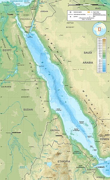
English: Topographic map in English of the Red Sea, UTM projection (WGS84 datum). Note : for translation purpose, use the SVG version.
Français : Carte topographique en anglais de la Mer Rouge, projection UTM (WGS84 datum).
Scales :
Topography: 1:3,708,000 (accuracy: 930 m) ;
Bathymetry: 1:7,500,000 (accuracy: 1,875 m) ;
Shorelines and additional data: 1:8,160,000 (accuracy: 2,040 m) (printing size: 18.8 x 30.73 cm).
Approximate geographic limits of the map (30" close) :
SW corner : 10° N – 31° 17' E
S-centre point : 10° 06' N – 38° E
SE corner : 10° 03' N – 44° 45' E
NE corner : 31° 47' N – 45° 40' E
N-centre point : 31° 57' N – 37° 49' E
NW corner : 31° 39' N – 30° 04' E
วันที่
แหล่งที่มา
Own work (see complete description on Image:Red_Sea_topographic_map-en.svg)
ผู้สร้างสรรค์
Eric Gaba (Sting - fr:Sting)
การอนุญาต (การใช้ไฟล์นี้ใหม่)
Attribution and Share-Alike required
Any use of this map can be made as long as you credit me (Eric Gaba – Wikimedia Commons user: Sting) as the author and distribute the copies and derivative works under the same license(s) that the one(s) stated below. A message with a reply address would also be greatly appreciated.
เวอร์ชันอื่น
[แก้ไข]
raster - العربية (مُترجمة)
SVG – deutsch (Übersetzung)
SVG – English (original)
raster - English
SVG – français (original)
bitmap - français
SVG - Hungarian (translation)
Македонски
SVG - Esperanto (translation)
Blank
This map was improved or created by the Wikigraphists of the Graphic Lab (fr). You can propose images to clean up, improve, create or translate as well.
This file is licensed under the Creative Commons Attribution-Share Alike 4.0 International, 3.0 Unported, 2.5 Generic, 2.0 Generic and 1.0 Generic license.
{{Location|21|00|00|N|38|00|00|E|scale:10000000}} <br/> {{Information |Description={{en|Topographic map in English of the red Sea<br/>''Note :'' for translation purpose, use the SVG version.}} {{fr
ไฟล, topographic, ไฟล, ประว, ไฟล, หน, าท, ภาพน, การใช, ไฟล, วนกลาง, อม, ลเก, ยวก, บภาพขนาดของต, วอย, างน, กเซล, ความละเอ, ยดอ, กเซล, กเซล, กเซล, กเซล, กเซล, ภาพท, ความละเอ, ยดส, งกว, 8206, กเซล, ขนาดไฟล, เมกะไบต, ชน, ดไมม, image, jpeg, ปภาพหร, อไฟล, เส, ยงน, น. ifl prawtiifl hnathimiphaphni karichiflswnklang khxmulekiywkbphaphkhnadkhxngtwxyangni 367 600 phikesl khwamlaexiydxun 147 240 phikesl 293 480 phikesl 470 768 phikesl 626 1 024 phikesl 1 655 2 705 phikesl duphaphthimikhwamlaexiydsungkwa 8206 1 655 2 705 phikesl khnadifl 1 68 emkaibt chnidimm image jpeg rupphaphhruxiflesiyngni tnchbbxyuthi khxmmxns raylaexiyddanlang epnkhxkhwamthiaesdngphlcak ifltnchbbinkhxmmxns khxmmxnsepnewbistinokhrngkarsahrbekbrwbrwmsuxesri thi khunsamarthchwyid khwamyx taaehnngthitngklxng21 00 00 ehnux 38 00 00 tawnxxk phaphniaelaphaphxun n sthanthiediywknthi OpenStreetMap21 000000 38 000000 khaxthibayRed Sea topographic map en jpg English Topographic map in English of the Red Sea UTM projection WGS84 datum Note for translation purpose use the SVG version Francais Carte topographique en anglais de la Mer Rouge projection UTM WGS84 datum Scales Topography 1 3 708 000 accuracy 930 m Bathymetry 1 7 500 000 accuracy 1 875 m Shorelines and additional data 1 8 160 000 accuracy 2 040 m printing size 18 8 x 30 73 cm Approximate geographic limits of the map 30 close SW corner 10 N 31 17 E S centre point 10 06 N 38 E SE corner 10 03 N 44 45 E NE corner 31 47 N 45 40 E N centre point 31 57 N 37 49 E NW corner 31 39 N 30 04 Ewnthi emsayn ph s 2551aehlngthima Own work see complete description on Image Red Sea topographic map en svg phusrangsrrkh Eric Gaba Sting fr Sting karxnuyat karichiflniihm Attribution and Share Alike requiredAny use of this map can be made as long as you credit me Eric Gaba Wikimedia Commons user Sting as the author and distribute the copies and derivative works under the same license s that the one s stated below A message with a reply address would also be greatly appreciated ewxrchnxun aekikh raster العربية م ترجمة SVG deutsch Ubersetzung SVG English original raster English SVG francais original bitmap francais SVG Hungarian translation Makedonski SVG Esperanto translation Blank This map was improved or created by the Wikigraphists of the Graphic Lab fr You can propose images to clean up improve create or translate as well karxnuyatichsiththi khapheca inthanaphuthuxlikhsiththikhxngphaphhruxsuxni xnuyatihichphaphhruxsuxniphayitenguxnikhtxipni xnuyatihkhdlxk aeckcayaela hruxddaeprexksarniphayitenguxnikhkhxngsyyaxnuyatexksaresrikhxngknu run 1 2 hruxrunid nbcaknithixxkodymulnithisxftaewresri odyimmiswnidhamaekikh immikhxkhwampkhnaaelapkhlng saenakhxngsyyaxnuyatrwmxyuinswnchux syyaxnuyatexksaresrikhxngknuhttp www gnu org copyleft fdl html GFDL GNU Free Documentation License true trueThis file is licensed under the Creative Commons Attribution Share Alike 4 0 International 3 0 Unported 2 5 Generic 2 0 Generic and 1 0 Generic license khunsamarth thicaaebngpn thicathasaena aeckcay aelasngngandngklawtxip thicaeriyberiyngihm thicaddaeplngngandngklaw phayitenguxnikhtxipni aesdngthima khuntxngihekiyrtiecakhxngnganxyangehmaasm odyephimlingkipyngsyyaxnuyat aelarabuhakmikarepliynaeplng khunxacthaechnniidinrupaebbidkidtamkhwr aettxngimichinlksnathiaenawaphuihxnuyatsnbsnunkhunhruxkarichngankhxngkhun xnuyataebbediywkn hakkhunddaeplng epliynrup hruxtxetimnganni khuntxngichsyyaxnuyataebbediywknhruxaebbthiehmuxnkbsyyaxnuyatthiichkbnganniethannhttps creativecommons org licenses by sa 4 0 CC BY SA 4 0 Creative Commons Attribution Share Alike 4 0 true truekhunsamartheluxksyyaxnuyatdngklawtamtxngkarkhabrryayodyyxithyephimkhabrryaythrrthdediywephuxkhyaykhwamwaiflnimixairixethmthiaesdngxyuiniflniprakxbdwysthanalikhsiththimilikhsiththisyyaxnuyatCreative Commons Attribution ShareAlike 3 0 Unported xngkvsCreative Commons Attribution ShareAlike 4 0 International xngkvsCreative Commons Attribution ShareAlike 2 5 Generic xngkvsCreative Commons Attribution ShareAlike 1 0 Generic xngkvsGNU Free Documentation License version 1 2 or later xngkvsCreative Commons Attribution ShareAlike 2 0 Generic xngkvswnthisrang wnkxtngemsayn 2008coordinates of the point of view xngkvs21 0 0 000 N 38 0 0 000 E prawtiifl khlikwnthi ewlaephuxduiflthipraktinkhnann wnthi ewlarupyxkhnadphuichkhwamehn pccubn20 37 19 krkdakhm 25531 655 2 705 1 68 emkaibt StingColor profile 11 47 2 knyayn 25511 655 2 705 1 6 emkaibt StingNew standard colors bathymetry from ETOPO1 etc 02 35 4 emsayn 25511 655 2 705 1 67 emkaibt StingAdditional corrections 20 09 3 emsayn 25511 655 2 705 1 71 emkaibt StingSome names corrections some improvements 18 26 3 emsayn 25511 655 2 705 1 67 emkaibt StingLittle correction 05 32 3 emsayn 25511 655 2 705 1 7 emkaibt Sting Location 21 00 00 N 38 00 00 E scale 10000000 lt br gt Information Description en Topographic map in English of the red Sea lt br gt 039 039 Note 039 039 for translation purpose use the SVG version fr hnathimiphaphni immihnaidoyngmathiphaphnikarichiflswnklang wikixuntxipniichiflni karichbn ami wikipedia org Eritrea karichbn am wikipedia org ቀይ ባሕር karichbn ban wikipedia org Segara Barak karichbn bg wikipedia org Bab el Mandeb karichbn bh wikipedia org ल ल स गर karichbn bn wikipedia org ল হ ত স গর karichbn ca wikipedia org Canal de Suez karichbn ckb wikipedia org دەریای سوور karichbn en wikipedia org Red Sea East African campaign World War II Red Sea Dam Portal Geography Featured picture 2008 week 41 Portal Geography Featured picture archive 2008 Attack on Convoy BN 7 Seas with colors names karichbn eu wikipedia org Itsaso Gorria karichbn fa wikipedia org دریای سرخ karichbn gu wikipedia org સ એઝ નહ ર karichbn hak wikipedia org Fung hoi karichbn he wikipedia org באב אל מנדב שיחת ויקיפדיה מיזמי ויקיפדיה יהדות אתיופיה בית לאברהם תבנית מפת מיקום הים האדום רעידת האדמה במפרץ אילת 1995 karichbn he wiktionary org ים סוף karichbn hi wikipedia org ब ब अल मन द ब जलसन ध karichbn ilo wikipedia org Baybay Nalabbasit karichbn incubator wikimedia org Wp mnc fulgiyan mederi Wp ann Okwaan Anyiaan karichbn ja wikipedia org スエズ運河 紅海 karichbn ja wikibooks org 中学校社会 地理 アフリカ州 karichbn kcg wikipedia org A shong Kyai A sa khwot karichbn kn wikipedia org ಕ ಪ ಸಮ ದ ರ karichbn ko wikipedia org 홍해 karichbn lfn wikipedia org Mar Roja karichbn lv wikipedia org Sarkana jura karichbn mai wikipedia org ल ल स गर karichbn ml wikipedia org ച ങ കടൽ karichbn ms wikipedia org Laut Merah karichbn my wikipedia org ပင လယ န karichbn ne wikipedia org र त स गर karichbn no wikipedia org Rodehavet karichbn olo wikipedia org Ruskeimeri karichbn pl wikipedia org Kampania wschodnioafrykanska w czasie II wojny swiatowej karichbn pnb wikipedia org لال سمندر باب المندب karichbn rm wikipedia org Mar Cotschna karichbn ro wikipedia org Marea Roșie karichbn sco wikipedia org Reid Sea karichbn simple wikipedia org Bab el Mandeb dukarichthwolkephimetimkhxngiflnikhxmulekiywkbphaph phaphnimikhxmulephimetim sungswnihymacakklxngdicitxlhruxsaeknenxrthisamarthekbkhxmuldngklawiwrwmkbphaphid thaphaphnithukprbprungaekikhhruxepliynaeplngcakedim khxmulbangxyangcayngkhngimepliynaeplngehmuxnphaphthithukprbprungaekikhnnkarcdwangphaphpktikhwamlaexiydaenwnxn89 dpikhwamlaexiydaenwtng89 dpisxftaewrthiichAdobe Photoshop 7 0aekikhphaphlasud10 36 19 krkdakhm 2553sepssiimidprbethiyb ekhathungcak https th wikipedia org wiki ifl Red Sea topographic map en jpg, wikipedia, วิกิ หนังสือ, หนังสือ, ห้องสมุด,