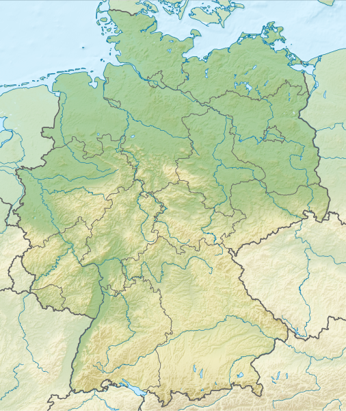
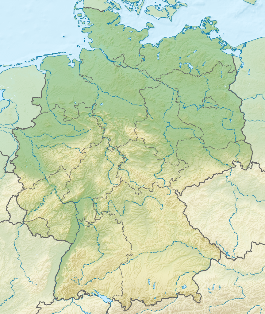
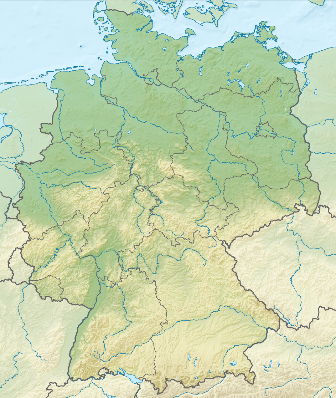
Deutsch: Positionskarte von Deutschland mit Gewässern
Quadratische Plattkarte, N-S-Streckung 150 %. Geographische Begrenzung der Karte:
N: 55.1° N
S: 47.2° N
W: 5.5° O
O: 15.5° O
English: Location map of Germany with waterbodies
Equirectangular projection, N/S stretching 150 %. Geographic limits of the map:
N: 55.1° N
S: 47.2° N
W: 5.5° E
E: 15.5° E
วันที่
แหล่งที่มา
งานของตัว
This vector image includes elements that have been taken or adapted from this file:
Germany2 location map.svg (โดย NordNordWest).
This vector image includes elements that have been taken or adapted from this file:
Relief Map of Germany.png (โดย Виктор В).
ผู้สร้างสรรค์
TUBS
เวอร์ชันอื่น
Bundesrepublik Deutschland (vor 1990 nur West-Deutschland):
Aktuelle Verwaltungsgliederung (seit Januar 2010 und Umgliederung der Luneplate von Niedersachsen nach Bremen)
Juli 1993 - Dezember 2009. Nach Umgliederung von Teilen des mecklenburgisch-vorpommerschen Landkreises Hagenow nach Niedersachsen, aber vor Umgliederung der Luneplate von Niedersachsen nach Bremen.)
August 1992 - Juni 1993: nach gegenseitigem Gebietstausch zwischen Brandenburg und Mecklenburg-Vorpommern betreffend u.a. Teile der Landkreise Strasburg, Pasewalk, Perleberg und Ludwigslust aber vor Umgliederung von Teilen des mecklenburgisch-vorpommerschen Landkreises Hagenow nach Niedersachsen.
April 1992 - Juli 1992: Nach Umgliederung von Teilen Thüringens (Teile der Landkreise Greiz, Zeulenroda und Schleiz) nach Sachsen aber vor gegenseitigem Gebietstausch zwischen Brandenburg und Mecklenburg-Vorpommern.
Oktober 1990 - März 1992. Nach der Wiedervereinigung, aber bevor Teile der thüringischen Landkreise Greiz, Zeulenroda und Schleiz nach Sachsen umgegliedert wurden.
Januar 1957 - Oktober 1990. Vor der Wiedervereinigung, aber nachdem das Saarland der Bundesrepublik beitrat.
September 1955 - Dezember 1956. Nachdem der Landkreis Lindau und Lindau wieder an Bayern fielen, aber noch bevor das Saarland zur Bundesrepublik beitrat.
April 1952 - August 1955. Nach Gründung Baden-Württembergs, aber bevor der Landkreis Lindau und Lindau endgültig wieder an Bayern fielen.
Dezember 1950 - April 1952: Nachdem der Landkreis Lindau und Lindau aus Württemberg-Hohenzollern endgültig ausschieden und ein länderfreies Sondergebiet wurden, aber bevor Baden-Württemberg gegründet wurde.
Oktober 1949 - November 1950: Nachdem die DDR gegründet wurde, aber bevor der Landkreis Lindau und Lindau aus Württemberg-Hohenzollern endgültig ausschieden und ein länderfreies Sondergebiet wurden.
Deutsche Demokratische Republik (mit BRD im Ausschnitt):
Januar 1957 - Oktober 1990: Nachdem das Saarland an die Bundesrepublik fiel, aber vor der Wiedervereinigung.
Juli 1952 - Januar 1957. Nach Auflösung der (alten) Länder in der DDR, aber bevor das Saarland an die Bundesrepublik fiel.
Oktober 1949 - Juli 1952: Nach Gründung der DDR, aber noch vor der Auflösung der Länder in der DDR.
Ostdeutschland (vor 1990 Deutsche Demokratische Republik):
Aktuell (seit Juli 1993 und Umgliederung von Teilen des mecklenburgisch-vorpommerschen Landkreises Hagenow nach Niedersachsen)
Juli 1952 - Oktober 1990: DDR nach Auflösung der Länder
Oktober 1949 - Juni 1952: DDR vor Auflösung der Länder
Deutschland zwischen Mai 1945 und Oktober 1949:
23. Mai 1949 - 6. Oktober 1949: Nachdem die BRD gegründet war, aber vor Gründung der DDR (Aus bundesrepublikanischer Perspektive)
23. Mai 1949 - 6. Oktober 1949: Nachdem die BRD gegründet war, aber vor Gründung der DDR (Aus Perspektive der Deutschen in der SBZ)
23. April 1949 - 22. Mai 1949: Nachdem die Niederlande das Selfkant unter Auftragsverwaltung nahmen, aber vor Gründung der BRD
8. Juni 1947 - 22. Mai 1949: Nach Korrekturen der rheinland-pfälzisch-saarländischen Grenze, aber bevor die Niederlande das Selfkant unter Auftragsverwaltung nahmen
Thematisch:
Autobahnen
Gewässer
Relief ohne Flüsse (PNG)
Relief mit Flüssen (SVG)
+Landkreise und Regierungsbezirke
+Kommunen, Kommunalverbände, Landkreise und Regierungsbezirke
Deutsches Reich (1871–1918) (best used with this template (de)):
Deutsches Reich 1914 mit Gliedstaaten und preußischen Provinzen
Deutsches Reich 1914 - ohne administrative Untereinheiten
Deutsches Reich (1918–1945) (best used with this template (de)):
Deutsches Reich 1937 mit Gliedstaaten und preußischen Provinzen
This large W3C-invalid SVG map was uploaded with Commonist.
This huge SVG map contains embedded raster graphics.[1] Such images are liable to produce inferior results when scaled to different sizes (as well as possibly being very inefficient in file size). If appropriate to do so, they should be replaced with images created using vector graphics. Note: This template is only supposed to be used if the SVG file mixes vector and raster graphics. If the SVG file only contains raster graphics {{FakeSVG}} is supposed to be used. See also {{TopoSVG}}.
I'd greatly appreciate, that you attribute this media file to Wikimedia Commons, if used outside Wikipedia or Commons. For use in publications such as books, newspapers, blogs, websites, please insert here the following line:
{{published|author= |date= |url= |title= |org= }}
and fill the applicable fields. (Example). License terms given above still apply.
বাংলা ∙ Deutsch ∙ Deutsch (Sie-Form) ∙ Ελληνικά ∙ English ∙ español ∙ français ∙ Ἀρχαία ἑλληνικὴ ∙ Bahasa Indonesia ∙ 日本語 ∙ македонски ∙ Nederlands ∙ português ∙ русский ∙ Türkçe ∙ 简体中文 ∙ 繁體中文 ∙ +/−
ไฟล, relief, germany, ไฟล, ประว, ไฟล, หน, าท, ภาพน, การใช, ไฟล, วนกลาง, อม, ลเก, ยวก, บภาพขนาดของต, วอย, าง, ของไฟล, กเซล, ความละเอ, ยดอ, กเซล, กเซล, กเซล, กเซล, กเซล, กเซล, ภาพท, ความละเอ, ยดส, งกว, 8206, ไฟล, กเซล, ขนาดไฟล, เมกะไบต, ปภาพหร, อไฟล, เส, ยงน, นฉ. ifl prawtiifl hnathimiphaphni karichiflswnklang khxmulekiywkbphaphkhnadkhxngtwxyang PNG nikhxngifl SVG ni 506 600 phikesl khwamlaexiydxun 202 240 phikesl 405 480 phikesl 648 768 phikesl 864 1 024 phikesl 1 728 2 048 phikesl 1 073 1 272 phikesl duphaphthimikhwamlaexiydsungkwa 8206 ifl SVG 1 073 1 272 phikesl khnadifl 6 54 emkaibt rupphaphhruxiflesiyngni tnchbbxyuthi khxmmxns raylaexiyddanlang epnkhxkhwamthiaesdngphlcak ifltnchbbinkhxmmxns khxmmxnsepnewbistinokhrngkarsahrbekbrwbrwmsuxesri thi khunsamarthchwyid khwamyx khaxthibayRelief Map of Germany svg Deutsch Positionskarte von Deutschland mit Gewassern Quadratische Plattkarte N S Streckung 150 Geographische Begrenzung der Karte N 55 1 N S 47 2 N W 5 5 O O 15 5 OEnglish Location map of Germany with waterbodies Equirectangular projection N S stretching 150 Geographic limits of the map N 55 1 N S 47 2 N W 5 5 E E 15 5 Ewnthi 30 phvscikayn ph s 2554aehlngthima ngankhxngtw This vector image includes elements that have been taken or adapted from this file Germany2 location map svg ody NordNordWest This vector image includes elements that have been taken or adapted from this file Relief Map of Germany png ody Viktor V phusrangsrrkh TUBSewxrchnxun Bundesrepublik Deutschland vor 1990 nur West Deutschland Aktuelle Verwaltungsgliederung seit Januar 2010 und Umgliederung der Luneplate von Niedersachsen nach Bremen Juli 1993 Dezember 2009 Nach Umgliederung von Teilen des mecklenburgisch vorpommerschen Landkreises Hagenow nach Niedersachsen aber vor Umgliederung der Luneplate von Niedersachsen nach Bremen August 1992 Juni 1993 nach gegenseitigem Gebietstausch zwischen Brandenburg und Mecklenburg Vorpommern betreffend u a Teile der Landkreise Strasburg Pasewalk Perleberg und Ludwigslust aber vor Umgliederung von Teilen des mecklenburgisch vorpommerschen Landkreises Hagenow nach Niedersachsen April 1992 Juli 1992 Nach Umgliederung von Teilen Thuringens Teile der Landkreise Greiz Zeulenroda und Schleiz nach Sachsen aber vor gegenseitigem Gebietstausch zwischen Brandenburg und Mecklenburg Vorpommern Oktober 1990 Marz 1992 Nach der Wiedervereinigung aber bevor Teile der thuringischen Landkreise Greiz Zeulenroda und Schleiz nach Sachsen umgegliedert wurden Januar 1957 Oktober 1990 Vor der Wiedervereinigung aber nachdem das Saarland der Bundesrepublik beitrat September 1955 Dezember 1956 Nachdem der Landkreis Lindau und Lindau wieder an Bayern fielen aber noch bevor das Saarland zur Bundesrepublik beitrat April 1952 August 1955 Nach Grundung Baden Wurttembergs aber bevor der Landkreis Lindau und Lindau endgultig wieder an Bayern fielen Dezember 1950 April 1952 Nachdem der Landkreis Lindau und Lindau aus Wurttemberg Hohenzollern endgultig ausschieden und ein landerfreies Sondergebiet wurden aber bevor Baden Wurttemberg gegrundet wurde Oktober 1949 November 1950 Nachdem die DDR gegrundet wurde aber bevor der Landkreis Lindau und Lindau aus Wurttemberg Hohenzollern endgultig ausschieden und ein landerfreies Sondergebiet wurden Deutsche Demokratische Republik mit BRD im Ausschnitt Januar 1957 Oktober 1990 Nachdem das Saarland an die Bundesrepublik fiel aber vor der Wiedervereinigung Juli 1952 Januar 1957 Nach Auflosung der alten Lander in der DDR aber bevor das Saarland an die Bundesrepublik fiel Oktober 1949 Juli 1952 Nach Grundung der DDR aber noch vor der Auflosung der Lander in der DDR Ostdeutschland vor 1990 Deutsche Demokratische Republik Aktuell seit Juli 1993 und Umgliederung von Teilen des mecklenburgisch vorpommerschen Landkreises Hagenow nach Niedersachsen Juli 1952 Oktober 1990 DDR nach Auflosung der Lander Oktober 1949 Juni 1952 DDR vor Auflosung der LanderDeutschland zwischen Mai 1945 und Oktober 1949 23 Mai 1949 6 Oktober 1949 Nachdem die BRD gegrundet war aber vor Grundung der DDR Aus bundesrepublikanischer Perspektive 23 Mai 1949 6 Oktober 1949 Nachdem die BRD gegrundet war aber vor Grundung der DDR Aus Perspektive der Deutschen in der SBZ 23 April 1949 22 Mai 1949 Nachdem die Niederlande das Selfkant unter Auftragsverwaltung nahmen aber vor Grundung der BRD 8 Juni 1947 22 Mai 1949 Nach Korrekturen der rheinland pfalzisch saarlandischen Grenze aber bevor die Niederlande das Selfkant unter Auftragsverwaltung nahmenThematisch Autobahnen Gewasser Relief ohne Flusse PNG Relief mit Flussen SVG Landkreise und Regierungsbezirke Kommunen Kommunalverbande Landkreise und RegierungsbezirkeDeutsches Reich 1871 1918 best used with this template de Deutsches Reich 1914 mit Gliedstaaten und preussischen Provinzen Deutsches Reich 1914 ohne administrative UntereinheitenDeutsches Reich 1918 1945 best used with this template de Deutsches Reich 1937 mit Gliedstaaten und preussischen ProvinzenSVG genesisInfoField sxrsokhdkhxngifl SVG khnadihyniimthuktxng enuxngcakphbkhxphidphlad14 aehng iflphaphkrafiksewketxr W3C trwcsxbaelwmikhxphidphladiniflthimikhnadihymakni srangkhunodyich Adobe Illustrator This large W3C invalid SVG map was uploaded with Commonist This huge SVG map contains embedded raster graphics 1 Such images are liable to produce inferior results when scaled to different sizes as well as possibly being very inefficient in file size If appropriate to do so they should be replaced with images created using vector graphics Note This template is only supposed to be used if the SVG file mixes vector and raster graphics If the SVG file only contains raster graphics FakeSVG is supposed to be used See also TopoSVG karxnuyatichsiththi khapheca inthanaphuthuxlikhsiththikhxngphaphhruxsuxni xnuyatihichphaphhruxsuxniphayitenguxnikhtxipniiflnixyuphayitsyyaxnuyat khriexthifkhxmmxns aebbaesdngthima xnuyataebbediywkn 3 0 tnchbbkhunsamarth thicaaebngpn thicathasaena aeckcay aelasngngandngklawtxip thicaeriyberiyngihm thicaddaeplngngandngklaw phayitenguxnikhtxipni aesdngthima khuntxngihekiyrtiecakhxngnganxyangehmaasm odyephimlingkipyngsyyaxnuyat aelarabuhakmikarepliynaeplng khunxacthaechnniidinrupaebbidkidtamkhwr aettxngimichinlksnathiaenawaphuihxnuyatsnbsnunkhunhruxkarichngankhxngkhun xnuyataebbediywkn hakkhunddaeplng epliynrup hruxtxetimnganni khuntxngichsyyaxnuyataebbediywknhruxaebbthiehmuxnkbsyyaxnuyatthiichkbnganniethannhttps creativecommons org licenses by sa 3 0 CC BY SA 3 0 Creative Commons Attribution Share Alike 3 0 true true I d greatly appreciate that you attribute this media file to Wikimedia Commons if used outside Wikipedia or Commons For use in publications such as books newspapers blogs websites please insert here the following line published author date url title org and fill the applicable fields Example License terms given above still apply ব ল Deutsch Deutsch Sie Form Ellhnika English espanol francais Ἀrxaia ἑllhnikὴ Bahasa Indonesia 日本語 makedonski Nederlands portugues russkij Turkce 简体中文 繁體中文 khabrryayodyyxithyephimkhabrryaythrrthdediywephuxkhyaykhwamwaiflnimixairixethmthiaesdngxyuiniflniprakxbdwyphusrangbangkhathiimmiixethmwikisnethschuxphusrangsrrkh TUBSchuxphuichwikimiediy TUBSyuxaraexl http commons wikimedia org wiki User TUBSsthanalikhsiththimilikhsiththisyyaxnuyatCreative Commons Attribution ShareAlike 3 0 Unported xngkvswnthisrang wnkxtng30 phvscikayn 2011thimakhxngiflkarsrangdngedimodyphuxpohld prawtiifl khlikwnthi ewlaephuxduiflthipraktinkhnann wnthi ewlarupyxkhnadphuichkhwamehn pccubn21 00 1 thnwakhm 25541 073 1 272 6 54 emkaibt TUBS hnathimiphaphni hnatxipni oyngmathiphaphni sukhchpithesx thaelsabobedin ebxrlin mxdul Location map data Germany mxdul Location map data Germany doc karichiflswnklang wikixuntxipniichiflni karichbn ar wikipedia org قالب خريطة مواقع ألمانيا جسر ماغديبورغ المركز الإسلامي في هامبورغ وحدة Location map data Deutschland وحدة Location map data Germany وحدة Location map data Germany شرح وحدة Location map data Deutschland شرح karichbn ast wikipedia org Modulu Minimapa data Alemana Modulu Minimapa data Alemana usu karichbn ban wikipedia org Taman Nasional Swiss Saxon Taman Nasional Hunsruck Hochwald Taman Nasional Eifel Taman Nasional Hainich Taman Nasional Kellerwald Edersee Taman Nasional Harz Taman Nasional Lebah Oder Sor Taman Nasional Muritz Taman Nasional Wawengkon Laguna Pomerania Kawan Taman Nasional Jasmund Taman Nasional Segara Wadden Saxon Sor karichbn ba wikipedia org Ҡalyp PozKarta Germaniya Elba karichbn bn wikipedia org ব র ল ন ট মপ ল ট অবস থ ন ম নচ ত র জ র ম ন ট মপ ল ট অবস থ ন ম নচ ত র জ র ম ন নথ স ট র নব র গ হ রদ মড উল অবস থ ন ম নচ ত র উপ ত ত জ র ম ন মড উল অবস থ ন ম নচ ত র উপ ত ত জ র ম ন নথ জ র ম ন র ভ গ ল karichbn br wikipedia org Dulmen karichbn bs wikipedia org Modul Location map data Deutschland Modul Location map data Germany Modul Location map data Njemacka Modul Location map data Germany dok karichbn bxr wikipedia org Berlin karichbn ca wikipedia org Batalla de Leipzig Plantilla Location map Alemanya Batalla de Muhlberg Batalla de Blenheim Batalla de Mogontiacum Batalla de Bautzen Batalla de Lutzen 1813 Batalla de Schellenberg Batalla de Jena Batalla de Drakenburg Modul Location map data Alemanya Modul Location map data Alemanya us Plantilla Infotaula conflicte militar proves Plantilla Infotaula conflicte militar proves us karichbn ceb wikipedia org Plantilya Location map Germany dukarichthwolkephimetimkhxngiflnikhxmulekiywkbphaph phaphnimikhxmulephimetim sungswnihymacakklxngdicitxlhruxsaeknenxrthisamarthekbkhxmuldngklawiwrwmkbphaphid thaphaphnithukprbprungaekikhhruxepliynaeplngcakedim khxmulbangxyangcayngkhngimepliynaeplngehmuxnphaphthithukprbprungaekikhnnkhwamkwang1073 381pxkhwamsung1271 953px ekhathungcak https th wikipedia org wiki ifl Relief Map of Germany svg, wikipedia, วิกิ หนังสือ, หนังสือ, ห้องสมุด,