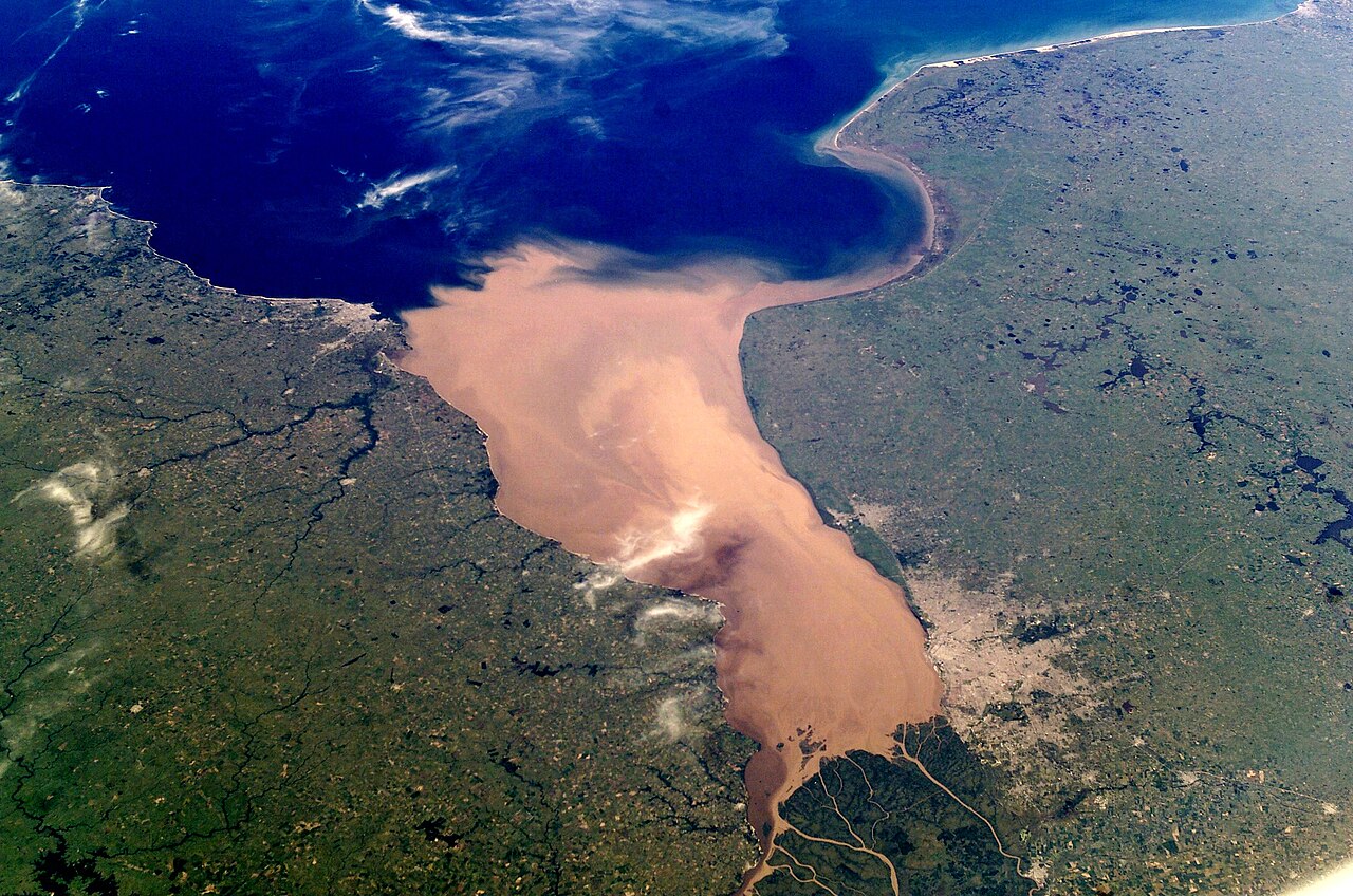
English: NASA astronaut photograph of the Río de la Plata estuary looking west-east, the picture does not show a north and south view. Actually the right is the south and the bottom of the picture is the west. Note Greater Buenos Aires on the right side of the picture, and Montevideo on the left side (near the mouth of the Santa Lucía. To the east of Greater Buenos Aires, a smaller conurbation is visible, including La Plata (a few kilometers inland) and the Berisso-Ensenada area (near the river). Water on the river is brown because of sediments carried from the Paraná and Uruguay rivers. The color turns blue when approaching the South Atlantic Ocean. The exact location of the color change (which also implies a change from fresh to salt water) depends on winds and currents.
Español: Foto del Río de la Plata tomada desde satélite, la cámara apunta hacia el sudeste. Se aprecia la desembocadura del río Río Uruguay y del Río Paraná. En la margen derecha destaca Buenos Aires y también la ciudad de La Plata; en la izquierda, se aprecia Montevideo, próximo a la desembocadura del Río Santa Lucía. En esta zona se observa cambio de color en el agua, la cual se torna más salada según se aproxima al Océano Atlántico.
Earth Sciences and Image Analysis Laboratory, NASA Johnson Space Center
การอนุญาตใช้สิทธิ
Public domainPublic domainfalsefalse
This image or video was catalogued by one of the centers of the United States National Aeronautics and Space Administration (NASA) under Photo ID: ISS006-E-38952.
This tag does not indicate the copyright status of the attached work. A normal copyright tag is still required.See Commons:Licensing.
Other languages:
العربية ∙ беларуская (тарашкевіца) ∙ български ∙ català ∙ čeština ∙ dansk ∙ Deutsch ∙ English ∙ español ∙ فارسی ∙ français ∙ galego ∙ magyar ∙ հայերեն ∙ Bahasa Indonesia ∙ italiano ∙ 日本語 ∙ македонски ∙ മലയാളം ∙ Nederlands ∙ polski ∙ português ∙ русский ∙ sicilianu ∙ slovenščina ∙ Türkçe ∙ українська ∙ 简体中文 ∙ 繁體中文 ∙ +/−
ไฟล, plata, ไฟล, ประว, ไฟล, หน, าท, ภาพน, การใช, ไฟล, วนกลางขนาดของต, วอย, างน, กเซล, ความละเอ, ยดอ, กเซล, กเซล, กเซล, กเซล, กเซล, ภาพท, ความละเอ, ยดส, งกว, 8206, กเซล, ขนาดไฟล, เมกะไบต, ชน, ดไมม, image, jpeg, ปภาพหร, อไฟล, เส, ยงน, นฉบ, บอย, คอมมอนส, รายละเอ,. ifl prawtiifl hnathimiphaphni karichiflswnklangkhnadkhxngtwxyangni 800 530 phikesl khwamlaexiydxun 320 212 phikesl 640 424 phikesl 1 024 678 phikesl 1 280 848 phikesl 3 032 2 008 phikesl duphaphthimikhwamlaexiydsungkwa 8206 3 032 2 008 phikesl khnadifl 1 75 emkaibt chnidimm image jpeg rupphaphhruxiflesiyngni tnchbbxyuthi khxmmxns raylaexiyddanlang epnkhxkhwamthiaesdngphlcak ifltnchbbinkhxmmxns khxmmxnsepnewbistinokhrngkarsahrbekbrwbrwmsuxesri thi khunsamarthchwyid khwamyx khaxthibayRio de la Plata BA 2 JPG English NASA astronaut photograph of the Rio de la Plata estuary looking west east the picture does not show a north and south view Actually the right is the south and the bottom of the picture is the west Note Greater Buenos Aires on the right side of the picture and Montevideo on the left side near the mouth of the Santa Lucia To the east of Greater Buenos Aires a smaller conurbation is visible including La Plata a few kilometers inland and the Berisso Ensenada area near the river Water on the river is brown because of sediments carried from the Parana and Uruguay rivers The color turns blue when approaching the South Atlantic Ocean The exact location of the color change which also implies a change from fresh to salt water depends on winds and currents Espanol Foto del Rio de la Plata tomada desde satelite la camara apunta hacia el sudeste Se aprecia la desembocadura del rio Rio Uruguay y del Rio Parana En la margen derecha destaca Buenos Aires y tambien la ciudad de La Plata en la izquierda se aprecia Montevideo proximo a la desembocadura del Rio Santa Lucia En esta zona se observa cambio de color en el agua la cual se torna mas salada segun se aproxima al Oceano Atlantico wnthi 17 minakhm ph s 2546 aehlngthima eol jsc nasa gov 1 phusrangsrrkh Earth Sciences and Image Analysis Laboratory NASA Johnson Space Center karxnuyatichsiththi Public domain Public domain false false phaphniepnsatharnsmbti enuxngcakepnphaphthisrangkhunodyxngkhkarbriharkarbinaelaxwkasaehngchati NASA sungtamnoybaydanlikhsiththikhxngnasarabuiwwa phaphaelasuxtang khxngnasaimidrbkarkhumkhrxngodylikhsiththiykewncarabuiwwamilikhsiththi duephimthi hnanoybaydanlikhsiththikhxngnasa hrux noybaykarichphaphkhxng JPL khaetuxn karich olokkhxngnasa ekhruxnghmayaelaekhruxngpradbkhxngnasa thukcakddwykdhmayshrthxemrikainlksna 14 khxngkhxbngkhbthangrachkarshrthxemrika swnthi 1221 ewbistkhxngnasaekbrwbrwmphaphthimacakxngkhkarxwkasosewiyt xngkhkarxwkasaehngchatirsesiy aelaxngkhkarxwkasthimiichxngkhkarxwkaskhxngshrthxemrika epncanwnmak phaphehlaniimcaepntxngepnsatharnsmbtiesmxip phaphhruxsuxthimacak klxngothrthrrsnxwkashbebil xacmilikhsiththi hakphaphhruxsuxnnimidrabuchdecnwamacak sthabnwithyasastrklxngothrthrrsnxwkas 2 phaphhruxsuxthnghmdthimacakekhruxngmuxkhxng okhrngkarsuksadwngxathityaelalmsuriya milikhsiththi karnaphaphhruxsuxcakokhrngkaripichnxkehnuxcakkarichephuxkarkhahruxephuxkarsuksa txngidrbxnuyatkxn 3 phaphthithukkhdeluxkihepn phaphdarasastrpracawn APOD bnewbistkhxng APOD xacmilikhsiththi 4 This image or video was catalogued by one of the centers of the United States National Aeronautics and Space Administration NASA nbsp under Photo nbsp ID ISS006 E 38952 This tag does not indicate the copyright status of the attached work A normal copyright tag is still required See Commons Licensing Other languages العربية nbsp belaruskaya tarashkevica nbsp blgarski nbsp catala nbsp cestina nbsp dansk nbsp Deutsch nbsp English nbsp espanol nbsp فارسی nbsp francais nbsp galego nbsp magyar nbsp հայերեն nbsp Bahasa Indonesia nbsp italiano nbsp 日本語 nbsp makedonski nbsp മലയ ള nbsp Nederlands nbsp polski nbsp portugues nbsp russkij nbsp sicilianu nbsp slovenscina nbsp Turkce nbsp ukrayinska nbsp 简体中文 nbsp 繁體中文 nbsp nbsp nikhuxphaphkhdsrrinwikiphiediyphasasepn Recursos destacados aela khux thuxwaepn phaphxyangidxyanghnungthidithisud thakhidwaiflnikhwrcaihkhwamsakhykbwikimiediykhxmmxnsepnxyangdi xyalngelthica esnxchux hakkhunmiphaphthimikhunphaph khlaykhlungkn thicasamarthephyaephridtam syyaxnuyatthiehmaasm ihaenicwa khunid xpohld kahndsyyaxnuyat aelaid esnxchuxaelw AnnotationsInfoFieldThis image is annotated View the annotations at Commons675 648 216 140 3032 2008 English Montevideo Russkij Montevideo 2024 1292 383 368 3032 2008 English Buenos Aires Russkij Buenos Ajres 1891 1091 174 136 3032 2008 La Plata 178 386 110 80 3032 2008 Punta del Este 1573 1341 80 80 3032 2008 Colonia del Sacramento 2289 1917 91 80 3032 2008 CampanakhabrryayodyyxithyephimkhabrryaythrrthdediywephuxkhyaykhwamwaiflnimixairsepnRio de la Plataixethmthiaesdngxyuiniflniprakxbdwywnthisrang wnkxtng17 minakhm 2003 prawtiifl khlikwnthi ewlaephuxduiflthipraktinkhnann wnthi ewlarupyxkhnadphuichkhwamehn pccubn17 12 26 kumphaphnth 25563 032 2 008 1 75 emkaibt DennissReverted to version as of 03 52 9 November 2011 10 52 9 phvscikayn 25543 032 2 008 1 75 emkaibt Creysmon07Corrected the contrast to more realistic 16 51 4 phvsphakhm 25523 032 2 008 1 37 emkaibt Monfornotremoved bottom border improved contrast a bit 04 14 8 singhakhm 25483 032 2 064 866 kiolibt ALE Larger version Colours not so exagerated more natural 10 18 29 phvscikayn 2547612 424 37 kiolibt Tano4595Rio de la Plata hnathimiphaphni hnatxipni oyngmathiphaphni chawakthael karichiflswnklang wikixuntxipniichiflni karichbn af wikipedia org Buenos Aires Wikipedia Voorbladartikels 2012 Wikipedia Voorbladartikel week 48 2012 Rio de la Plata karichbn ar wikipedia org بوابة بوينس آيرس بوابة بوينس آيرس مقالة مختارة أرشيف بوابة بوينس آيرس مقالة مختارة 2 karichbn ast wikipedia org Provincia de Buenos Aires Conu Sur Cuenca de la Plata karichbn azb wikipedia org اوروقوئه ریو دلا پلاتا چایی karichbn bar wikipedia org Rio de la Plata karichbn be tarask wikipedia org Buenas Ajres karichbn be wikipedia org Buenas Ajres karichbn bg wikipedia org Estuar karichbn bh wikipedia org र य ड ल प ल ट karichbn bn wikibooks org উইক শ শব দক ষ ণ আম র ক আর জ ন ট ন karichbn br wikipedia org Rio de la Plata karichbn bs wikipedia org Rio de la Plata karichbn ca wikipedia org Capital Delta fluvial Estuari Sudestada Massa d aigua Viquipedia Imatge del dia 2015 karichbn cs wikipedia org Montevideo Geografie Argentiny karichbn da wikipedia org Argentina karichbn de wikipedia org Argentinien Buenos Aires Hauptstadt Uruguay Rio de la Plata Geographie Argentiniens Wikipedia Diskussion Hauptseite Artikel des Tages Archiv Vorschlage 2015 Q3 Wikipedia Hauptseite Archiv 25 August 2015 karichbn en wikipedia org Estuary Rio de la Plata Buenos Aires tetra Front oceanography karichbn en wikibooks org Wikijunior South America Argentina karichbn en wiktionary org Rio de la Plata karichbn eo wikipedia org Argentino Rivero Plata Rivero karichbn es wikipedia org Rio de la Plata Rio Buenos Aires Provincia de Buenos Aires dukarichthwolkephimetimkhxngiflni ekhathungcak https th wikipedia org wiki ifl Rio de la Plata BA 2 JPG, wikipedia, วิกิ หนังสือ, หนังสือ, ห้องสมุด,