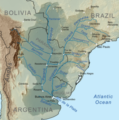
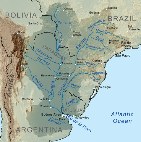
== Summary == {{Information |Description=Map showing the Río de la Plata drainage basin including major tributaries and cities. |Source={{own}}, Elevation data from SRTM, drainage basin from
ไฟล, riodelaplatabasinmap, ไฟล, ประว, ไฟล, หน, าท, ภาพน, การใช, ไฟล, วนกลางขนาดของต, วอย, างน, กเซล, ความละเอ, ยดอ, กเซล, กเซล, กเซล, กเซล, กเซล, ภาพท, ความละเอ, ยดส, งกว, 8206, กเซล, ขนาดไฟล, เมกะไบต, ชน, ดไมม, image, ปภาพหร, อไฟล, เส, ยงน, นฉบ, บอย, คอมมอนส,. ifl prawtiifl hnathimiphaphni karichiflswnklangkhnadkhxngtwxyangni 596 600 phikesl khwamlaexiydxun 238 240 phikesl 477 480 phikesl 763 768 phikesl 1 017 1 024 phikesl 1 500 1 510 phikesl duphaphthimikhwamlaexiydsungkwa 8206 1 500 1 510 phikesl khnadifl 3 14 emkaibt chnidimm image png rupphaphhruxiflesiyngni tnchbbxyuthi khxmmxns raylaexiyddanlang epnkhxkhwamthiaesdngphlcak ifltnchbbinkhxmmxns khxmmxnsepnewbistinokhrngkarsahrbekbrwbrwmsuxesri thi khunsamarthchwyid khwamyx khaxthibayRiodelaplatabasinmap png English Map showing the Rio de la Plata drainage basin including major tributaries and cities Espanol Mapa que muestra la cuenca de drenaje del Rio de la Plata incluidos los principales afluentes y ciudades wnthi 6 tulakhm ph s 2553aehlngthima ngankhxngtw Elevation data from SRTM drainage basin from GTOPO 1 all other features from Vector Map phusrangsrrkh Kmusserewxrchnxun This file has an extracted image File TrianguloMineiro png العربي ة francais karxnuyatichsiththi khapheca inthanaphuthuxlikhsiththikhxngphaphhruxsuxni xnuyatihichphaphhruxsuxniphayitenguxnikhtxipniiflnixyuphayitsyyaxnuyat khriexthifkhxmmxns aebbaesdngthima xnuyataebbediywkn 3 0 tnchbbkhunsamarth thicaaebngpn thicathasaena aeckcay aelasngngandngklawtxip thicaeriyberiyngihm thicaddaeplngngandngklaw phayitenguxnikhtxipni aesdngthima khuntxngihekiyrtiecakhxngnganxyangehmaasm odyephimlingkipyngsyyaxnuyat aelarabuhakmikarepliynaeplng khunxacthaechnniidinrupaebbidkidtamkhwr aettxngimichinlksnathiaenawaphuihxnuyatsnbsnunkhunhruxkarichngankhxngkhun xnuyataebbediywkn hakkhunddaeplng epliynrup hruxtxetimnganni khuntxngichsyyaxnuyataebbediywknhruxaebbthiehmuxnkbsyyaxnuyatthiichkbnganniethannhttps creativecommons org licenses by sa 3 0 CC BY SA 3 0 Creative Commons Attribution Share Alike 3 0 true truekhabrryayodyyxithyephimkhabrryaythrrthdediywephuxkhyaykhwamwaiflnimixairsepnMapa que muestra la cuenca de drenaje del Rio de la Plata incluidos los principales afluentes y ciudades ixethmthiaesdngxyuiniflniprakxbdwyphusrangbangkhathiimmiixethmwikisnethschuxphuichwikimiediy Kmusserchuxphusrangsrrkh Kmusseryuxaraexl https commons wikimedia org wiki user KmussersthanalikhsiththimilikhsiththisyyaxnuyatCreative Commons Attribution ShareAlike 3 0 Unported xngkvswnthisrang wnkxtng6 tulakhm 2010thimakhxngiflkarsrangdngedimodyphuxpohldMIME type xngkvsimage png prawtiifl khlikwnthi ewlaephuxduiflthipraktinkhnann wnthi ewlarupyxkhnadphuichkhwamehn pccubn23 43 6 tulakhm 25531 500 1 510 3 14 emkaibt Kmusser Summary Information Description Map showing the Rio de la Plata drainage basin including major tributaries and cities Source own Elevation data from SRTM drainage basin from hnathimiphaphni hnatxipni oyngmathiphaphni aemnatiexet aemnaxikwasu karichiflswnklang wikixuntxipniichiflni karichbn af wikipedia org Rio Parana Rio Paraguay Rio Uruguay Rio Pilcomayo Rio de la Plata Platynse Oorloe Rio Bermejo Rio Iguazu Rio Salado karichbn ar wikipedia org ويكيبيديا ورشة الصور أرشيف 40 karichbn ast wikipedia org Riu de la Plata Cuenca de la Plata karichbn azb wikipedia org ریو دلا پلاتا چایی پارانا چایی karichbn az wikipedia org Paraqvay cayi La Plata hovzesi olkeleri karichbn bar wikipedia org Rio de la Plata Rio Paranaiba karichbn be wikipedia org Paragvaj raka Iguasu raka Rya Negra prytok Urugvaya Laplackaya nizina karichbn bg wikipedia org La Plata Urugvaj reka Laplatska nizina karichbn bh wikipedia org पर न नद र य ड ल प ल ट karichbn bn wikipedia org উর গ য নদ karichbn br wikipedia org Rio Uruguay Rio Canoas Pepiri Guazu Ster Iguacu karichbn bs wikipedia org Parana rijeka Rio de la Plata karichbn ca wikipedia org Historia de l Argentina Riu de la Plata Riu Parana Riu Paraguai Riu Iguacu Conca del Parana Conca de la Plata Riu Paranaiba Rio Negro Uruguai Descobriment i conquesta de l Argentina Riu Paranapanema karichbn ceb wikipedia org Rio Canoas suba sa Brasil Santa Catarina lat 27 60 long 51 42 karichbn cs wikipedia org Rio Grande pritok Parana Parana reka Paraguay reka Paranaiba dukarichthwolkephimetimkhxngiflni ekhathungcak https th wikipedia org wiki ifl Riodelaplatabasinmap png, wikipedia, วิกิ หนังสือ, หนังสือ, ห้องสมุด,