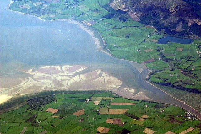
The estuary of the River Nith, Scotland, at low tide; opening into Solway Firth. This is a view of the Nith estuary from the north-east. The group of buildings at bottom right is the village of Glencaple. At bottom left near the wooded area is Caerlaverock Castle. At top right is Loch Kindar and the hill above is called Criffel. Just beyond the top left of photo is the birthplace of John Paul Jones.
This image was originally posted to Flickr by dsearls at https://www.flickr.com/photos/52614599@N00/483602946. It was reviewed on 5 พฤษภาคม พ.ศ. 2550 by FlickreviewR and was confirmed to be licensed under the terms of the cc-by-sa-2.0.
5 พฤษภาคม พ.ศ. 2550
This is a view of the Nith estuary from the north-east. The group of buildings at bottom right is the village of Glencaple. At bottom left near the wooded area is Caerlaverock Castle. At top right is Loch Kindar and the hill above is called Criffel. Just beyond the top left of photo is the birthplace of John Paul Jones.
{{Information |Description= The estuary of the River Nith, Scotland, at low tide; opening into Solway Firth. On the near shore, Bowness-on-Solway. On the far, Annan, in Dumfries and Galloway. |Source= http://www.flickr.com/photos/52614599@N00/483602946 |D
ไฟล, river, nith, estuary, ไฟล, ประว, ไฟล, หน, าท, ภาพน, การใช, ไฟล, วนกลาง, อม, ลเก, ยวก, บภาพขนาดของต, วอย, างน, กเซล, ความละเอ, ยดอ, กเซล, กเซล, กเซล, กเซล, กเซล, กเซล, ภาพท, ความละเอ, ยดส, งกว, 8206, กเซล, ขนาดไฟล, เมกะไบต, ชน, ดไมม, image, jpeg, ปภาพหร, อ. ifl prawtiifl hnathimiphaphni karichiflswnklang khxmulekiywkbphaphkhnadkhxngtwxyangni 800 533 phikesl khwamlaexiydxun 320 213 phikesl 640 427 phikesl 1 024 683 phikesl 1 280 853 phikesl 2 560 1 707 phikesl 3 504 2 336 phikesl duphaphthimikhwamlaexiydsungkwa 8206 3 504 2 336 phikesl khnadifl 8 68 emkaibt chnidimm image jpeg rupphaphhruxiflesiyngni tnchbbxyuthi khxmmxns raylaexiyddanlang epnkhxkhwamthiaesdngphlcak ifltnchbbinkhxmmxns khxmmxnsepnewbistinokhrngkarsahrbekbrwbrwmsuxesri thi khunsamarthchwyid khwamyx khaxthibayRiver Nith estuary jpg The estuary of the River Nith Scotland at low tide opening into Solway Firth This is a view of the Nith estuary from the north east The group of buildings at bottom right is the village of Glencaple At bottom left near the wooded area is Caerlaverock Castle At top right is Loch Kindar and the hill above is called Criffel Just beyond the top left of photo is the birthplace of John Paul Jones wnthi 2 phvsphakhm ph s 2550 11 31aehlngthima https www flickr com photos 52614599 N00 483602946phusrangsrrkh Doc Searls from Santa Barbara USA karxnuyatichsiththi iflnixyuphayitsyyaxnuyat khriexthifkhxmmxns aebbaesdngthima xnuyataebbediywkn 2 0 thwipkhunsamarth thicaaebngpn thicathasaena aeckcay aelasngngandngklawtxip thicaeriyberiyngihm thicaddaeplngngandngklaw phayitenguxnikhtxipni aesdngthima khuntxngihekiyrtiecakhxngnganxyangehmaasm odyephimlingkipyngsyyaxnuyat aelarabuhakmikarepliynaeplng khunxacthaechnniidinrupaebbidkidtamkhwr aettxngimichinlksnathiaenawaphuihxnuyatsnbsnunkhunhruxkarichngankhxngkhun xnuyataebbediywkn hakkhunddaeplng epliynrup hruxtxetimnganni khuntxngichsyyaxnuyataebbediywknhruxaebbthiehmuxnkbsyyaxnuyatthiichkbnganniethannhttps creativecommons org licenses by sa 2 0 CC BY SA 2 0 Creative Commons Attribution Share Alike 2 0 true true This image was originally posted to Flickr by dsearls at https www flickr com photos 52614599 N00 483602946 It was reviewed on 5 phvsphakhm ph s 2550 by FlickreviewR and was confirmed to be licensed under the terms of the cc by sa 2 0 5 phvsphakhm ph s 2550This is a view of the Nith estuary from the north east The group of buildings at bottom right is the village of Glencaple At bottom left near the wooded area is Caerlaverock Castle At top right is Loch Kindar and the hill above is called Criffel Just beyond the top left of photo is the birthplace of John Paul Jones khabrryayodyyxithyephimkhabrryaythrrthdediywephuxkhyaykhwamwaiflnimixairixethmthiaesdngxyuiniflniprakxbdwysthanalikhsiththimilikhsiththisyyaxnuyatCreative Commons Attribution ShareAlike 2 0 Generic xngkvswnthisrang wnkxtng2 phvsphakhm 2007bnthukphaphdwyCanon EOS 30D xngkvsexposure time xngkvs0 004 winathif number xngkvs9focal length xngkvs87 milliemtrISO speed xngkvs100epnphaphthaythimakhxngiflfile available on the internet xngkvsphudaeninkar flikhekxrxthibayin URL https www flickr com photos 52614599 N00 483602946 prawtiifl khlikwnthi ewlaephuxduiflthipraktinkhnann wnthi ewlarupyxkhnadphuichkhwamehn pccubn14 14 5 phvsphakhm 25503 504 2 336 8 68 emkaibt Sandstein Information Description The estuary of the River Nith Scotland at low tide opening into Solway Firth On the near shore Bowness on Solway On the far Annan in Dumfries and Galloway Source http www flickr com photos 52614599 N00 483602946 D hnathimiphaphni hnatxipni oyngmathiphaphni chawakthael karichiflswnklang wikixuntxipniichiflni karichbn ar wikipedia org مصب karichbn arz wikipedia org نهر نيث karichbn ast wikipedia org Fiordu de Solway karichbn bn wikipedia org সলওয ফ র থ karichbn br wikipedia org Firth Solway Firth karichbn ceb wikipedia org River Nith karichbn cs wikipedia org Nith karichbn cy wikipedia org Yr Alban Afon Nith karichbn de wikipedia org Bowness on Solway Nith National Scenic Area karichbn en wikipedia org Solway Firth Firth Dumfries and Galloway River Nith List of places in Cumbria Geography of Scotland List of rivers of Scotland karichbn en wikivoyage org United Kingdom national parks karichbn eo wikipedia org Dumfries kaj Galloway karichbn es wikipedia org Fiordo de Solway Firth Rio Nith karichbn eu wikipedia org Dumfries eta Galloway Dumfries Solwayko fiordoa Nith ibaia Eskoziako geografia karichbn fa wikipedia org دامفریس و گالووی خور سالوی karichbn fr wikipedia org Nith Ecosse karichbn fy wikipedia org Nith karichbn ga wikipedia org Abhainn Nid karichbn gd wikipedia org Abhainn Nid karichbn gv wikipedia org Inver karichbn hak wikipedia org Ho khieu van karichbn id wikipedia org Estuari karichbn it wikipedia org Dumfries e Galloway Firth karichbn it wikibooks org Scienze della Terra per le superiori I fiumi karichbn it wikiversity org I fiumi superiori karichbn ja wikipedia org ソルウェー湾 Firth karichbn kbd wikipedia org Iestuarij Firf karichbn lt wikipedia org Skotijos geografija karichbn nl wikipedia org Nith Firth water dukarichthwolkephimetimkhxngiflnikhxmulekiywkbphaph phaphnimikhxmulephimetim sungswnihymacakklxngdicitxlhruxsaeknenxrthisamarthekbkhxmuldngklawiwrwmkbphaphid thaphaphnithukprbprungaekikhhruxepliynaeplngcakedim khxmulbangxyangcayngkhngimepliynaeplngehmuxnphaphthithukprbprungaekikhnnphuphlitklxngCanonrunkhxngklxngCanon EOS 30Dewlaepidhnaklxng1 250 winathi 0 004 khaexff 9xtrakhwamerw ISO100ewlathibnthukphaph11 31 2 phvsphakhm 2550khwamyawofkselns87 mm karcdwangphaphpktikhwamlaexiydaenwnxn72 dpikhwamlaexiydaenwtng72 dpisxftaewrthiichAdobe Photoshop CS2 Macintoshaekikhphaphlasud08 31 3 phvsphakhm 2550taaehnng Y aela CCo sitedopraekrmexksophechxropraekrmpktirunexksif Exif 2 21ewlathiaeplngepndicithl11 31 2 phvsphakhm 2550khwamerwchtetxr7 9657897949219kharurbaesng A 6 33984375karchdechyaesng0ohmdkarwdaesngspxtaeflchimichaeflch rangbichaeflchsepssisRGBkhwamlaexiydranabofks X3 959 3220338983khwamlaexiydranabofks Y3 959 3220338983hnwykhwamlaexiydranabofksniwkarpramwlphaphophlessspktiohmdexksophechxrexksophechxrxtonmtiiwtbalansiwtbalansxtonmtichnidsinaekhpecxrpkti ekhathungcak https th wikipedia org wiki ifl River Nith estuary jpg, wikipedia, วิกิ หนังสือ, หนังสือ, ห้องสมุด,