รูปภาพหรือไฟล์เสียงนี้ ต้นฉบับอยู่ที่ คอมมอนส์ รายละเอียดด้านล่าง เป็นข้อความที่แสดงผลจาก ไฟล์ต้นฉบับในคอมมอนส์ คอมมอนส์เป็นเว็บไซต์ในโครงการสำหรับเก็บรวบรวมสื่อเสรี ที่ คุณสามารถช่วยได้
ความย่อ คำอธิบายSCORE Risk Charts Europe map.png English:
Polski:
วันที่ 17 พฤศจิกายน พ.ศ. 2557 แหล่งที่มา Blank political map of Europe EU27 iso3166-1 code.svg ผู้สร้างสรรค์ Blank political map of Europe EU27 iso3166-1 code.svg: Amibreton derivative work: Pnapora
ภาพนี้ ได้รับการปรับแต่งภาพ Highlighed SCORE cardiovascular risk . ต้นฉบับสามารถดูได้ที่นี่: Blank political map of Europe EU27 iso3166-1 code.svg . ปรับแต่งภาพโดย Pnapora.
การอนุญาตใช้สิทธิ ข้าพเจ้า ในฐานะผู้ถือลิขสิทธิ์ของภาพหรือสื่อนี้ อนุญาตให้ใช้ภาพหรือสื่อนี้ภายใต้เงื่อนไขต่อไปนี้
ไฟล์นี้อยู่ภายใต้สัญญาอนุญาต ครีเอทีฟคอมมอนส์ แบบแสดงที่มา-อนุญาตแบบเดียวกัน 4.0 นานาชาติ
คุณสามารถ: ที่จะแบ่งปัน – ที่จะทำสำเนา แจกจ่าย และส่งงานดังกล่าวต่อไปที่จะเรียบเรียงใหม่ – ที่จะดัดแปลงงานดังกล่าว ภายใต้เงื่อนไขต่อไปนี้: แสดงที่มา – คุณต้องให้เกียรติเจ้าของงานอย่างเหมาะสม โดยเพิ่มลิงก์ไปยังสัญญาอนุญาต และระบุหากมีการเปลี่ยนแปลง คุณอาจทำเช่นนี้ได้ในรูปแบบใดก็ได้ตามควร แต่ต้องไม่ใช่ในลักษณะที่แนะว่าผู้ให้อนุญาตสนับสนุนคุณหรือการใช้งานของคุณอนุญาตแบบเดียวกัน – หากคุณดัดแปลง เปลี่ยนรูป หรือต่อเติมงานนี้ คุณต้องใช้สัญญาอนุญาตแบบเดียวกันหรือแบบที่เหมือนกับสัญญาอนุญาตที่ใช้กับงานนี้เท่านั้น https://creativecommons.org/licenses/by-sa/4.0 CC BY-SA 4.0 Creative Commons Attribution-Share Alike 4.0 true true This image is a derivative work of the following images:
File:Blank_map_of_Europe_EU27_iso3166-1_code.svg licensed with Cc-by-sa-2.5 2009-03-14T10:55:56Z Amibreton 454x450 (490785 Bytes) {{Information |Description={{en|1=Blank Map of Europe in SVG format oriented towards EU-27 (European Union of 27 member states) mapping. Each country has an id which is its ISO-3116-1-ALPHA2 code in lower case for easy colour ไทย เพิ่มคำบรรยายทรรทัดเดียวเพื่อขยายความว่าไฟล์นี้มีอะไร
ประวัติไฟล์ คลิกวันที่/เวลาเพื่อดูไฟล์ที่ปรากฏในขณะนั้น
วันที่/เวลา รูปย่อ ขนาด ผู้ใช้ ความเห็น ปัจจุบัน 19:38, 14 กันยายน 2565 2,123 × 1,716 (474 กิโลไบต์) Рагин1987 Extended map 03:53, 26 สิงหาคม 2565 2,000 × 1,982 (422 กิโลไบต์) Рагин1987 Added Turkey (East Thrace) 06:04, 26 พฤศจิกายน 2557 2,000 × 1,982 (413 กิโลไบต์) Fallaner better colors 06:02, 26 พฤศจิกายน 2557 2,000 × 1,982 (413 กิโลไบต์) Fallaner better colours 05:08, 18 พฤศจิกายน 2557 2,000 × 1,982 (406 กิโลไบต์) Fallaner User created page with UploadWizard
หน้าที่มีภาพนี้ หน้าต่อไปนี้ โยงมาที่ภาพนี้:
การใช้ไฟล์ส่วนกลาง วิกิอื่นต่อไปนี้ใช้ไฟล์นี้:
ภาพนี้มีข้อมูลเพิ่มเติม ซึ่งส่วนใหญ่มาจากกล้องดิจิตอลหรือสแกนเนอร์ที่สามารถเก็บข้อมูลดังกล่าวไว้รวมกับภาพได้ ถ้าภาพนี้ถูกปรับปรุงแก้ไขหรือเปลี่ยนแปลงจากเดิม ข้อมูลบางอย่างจะยังคงไม่เปลี่ยนแปลงเหมือนภาพที่ถูกปรับปรุงแก้ไขนั้น
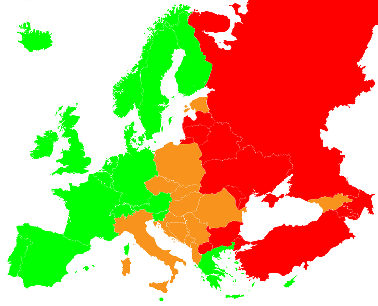
ไฟล, score, risk, charts, europe, ไฟล, ประว, ไฟล, หน, าท, ภาพน, การใช, ไฟล, วนกลาง, อม, ลเก, ยวก, บภาพขนาดของต, วอย, างน, กเซล, ความละเอ, ยดอ, กเซล, กเซล, กเซล, กเซล, กเซล, ภาพท, ความละเอ, ยดส, งกว, 8206, กเซล, ขนาดไฟล, โลไบต, ชน, ดไมม, image, ปภาพหร, อไฟล, เส. ifl prawtiifl hnathimiphaphni karichiflswnklang khxmulekiywkbphaphkhnadkhxngtwxyangni 742 600 phikesl khwamlaexiydxun 297 240 phikesl 594 480 phikesl 950 768 phikesl 1 267 1 024 phikesl 2 123 1 716 phikesl duphaphthimikhwamlaexiydsungkwa 8206 2 123 1 716 phikesl khnadifl 474 kiolibt chnidimm image png rupphaphhruxiflesiyngni tnchbbxyuthi khxmmxns raylaexiyddanlang epnkhxkhwamthiaesdngphlcak ifltnchbbinkhxmmxns khxmmxnsepnewbistinokhrngkarsahrbekbrwbrwmsuxesri thi khunsamarthchwyid khwamyx khaxthibaySCORE Risk Charts Europe map png English Europe map of SCORE Risk Charts red colour very high risk green colour low risk orange colour high risk Polski Ryzyko incydentu sercowo naczyniowego wg skali SCORE czerwony kraje bardzo wysokiego ryzyka pomaranczowy kraje wysokiego ryzyka zielono kraje niskiego ryzyka wnthi 17 phvscikayn ph s 2557aehlngthima Blank political map of Europe EU27 iso3166 1 code svgphusrangsrrkh Blank political map of Europe EU27 iso3166 1 code svg Amibreton derivative work Pnapora phaphni idrbkarprbaetngphaph sunghmaykhwamwacaidrbkarepliynaeplngphaphtangcaktnchbb karprbprung Highlighed SCORE cardiovascular risk tnchbbsamarthduidthini Blank political map of Europe EU27 iso3166 1 code svg prbaetngphaphody Pnapora karxnuyatichsiththi khapheca inthanaphuthuxlikhsiththikhxngphaphhruxsuxni xnuyatihichphaphhruxsuxniphayitenguxnikhtxipniiflnixyuphayitsyyaxnuyat khriexthifkhxmmxns aebbaesdngthima xnuyataebbediywkn 4 0 nanachatikhunsamarth thicaaebngpn thicathasaena aeckcay aelasngngandngklawtxip thicaeriyberiyngihm thicaddaeplngngandngklaw phayitenguxnikhtxipni aesdngthima khuntxngihekiyrtiecakhxngnganxyangehmaasm odyephimlingkipyngsyyaxnuyat aelarabuhakmikarepliynaeplng khunxacthaechnniidinrupaebbidkidtamkhwr aettxngimichinlksnathiaenawaphuihxnuyatsnbsnunkhunhruxkarichngankhxngkhun xnuyataebbediywkn hakkhunddaeplng epliynrup hruxtxetimnganni khuntxngichsyyaxnuyataebbediywknhruxaebbthiehmuxnkbsyyaxnuyatthiichkbnganniethannhttps creativecommons org licenses by sa 4 0 CC BY SA 4 0 Creative Commons Attribution Share Alike 4 0 true true This image is a derivative work of the following images File Blank map of Europe EU27 iso3166 1 code svg licensed with Cc by sa 2 5 2009 03 14T10 55 56Z Amibreton 454x450 490785 Bytes Information Description en 1 Blank Map of Europe in SVG format oriented towards EU 27 European Union of 27 member states mapping Each country has an id which is its ISO 3116 1 ALPHA2 code in lower case for easy colourkhabrryayodyyxithyephimkhabrryaythrrthdediywephuxkhyaykhwamwaiflnimixairixethmthiaesdngxyuiniflniprakxbdwysthanalikhsiththimilikhsiththisyyaxnuyatCreative Commons Attribution ShareAlike 4 0 International xngkvswnthisrang wnkxtng17 phvscikayn 2014MIME type xngkvsimage png prawtiifl khlikwnthi ewlaephuxduiflthipraktinkhnann wnthi ewlarupyxkhnadphuichkhwamehn pccubn19 38 14 knyayn 25652 123 1 716 474 kiolibt Ragin1987Extended map 03 53 26 singhakhm 25652 000 1 982 422 kiolibt Ragin1987Added Turkey East Thrace 06 04 26 phvscikayn 25572 000 1 982 413 kiolibt Fallanerbetter colors 06 02 26 phvscikayn 25572 000 1 982 413 kiolibt Fallanerbetter colours 05 08 18 phvscikayn 25572 000 1 982 406 kiolibt FallanerUser created page with UploadWizard hnathimiphaphni hnatxipni oyngmathiphaphni saettin karichiflswnklang wikixuntxipniichiflni karichbn pl wikipedia org Statynykhxmulekiywkbphaph phaphnimikhxmulephimetim sungswnihymacakklxngdicitxlhruxsaeknenxrthisamarthekbkhxmuldngklawiwrwmkbphaphid thaphaphnithukprbprungaekikhhruxepliynaeplngcakedim khxmulbangxyangcayngkhngimepliynaeplngehmuxnphaphthithukprbprungaekikhnnkhwamlaexiydaenwnxn37 79 dpckhwamlaexiydaenwtng37 79 dpc ekhathungcak https th wikipedia org wiki ifl SCORE Risk Charts Europe map png, wikipedia, วิกิ หนังสือ, หนังสือ, ห้องสมุด,
บทความ , อ่าน, ดาวน์โหลด, ฟรี, ดาวน์โหลดฟรี, mp3, วิดีโอ, mp4, 3gp, jpg, jpeg, gif, png, รูปภาพ, เพลง, เพลง, หนัง, หนังสือ, เกม, เกม