This file requires updating because: south soudan In doing so, you could add a timestamp to the file.
Please notify the uploader with {{subst:update-note|1=File:Sahel Map-Africa rough.png|2=south soudan}} ~~~~
คำอธิบายSahel Map-Africa rough.png
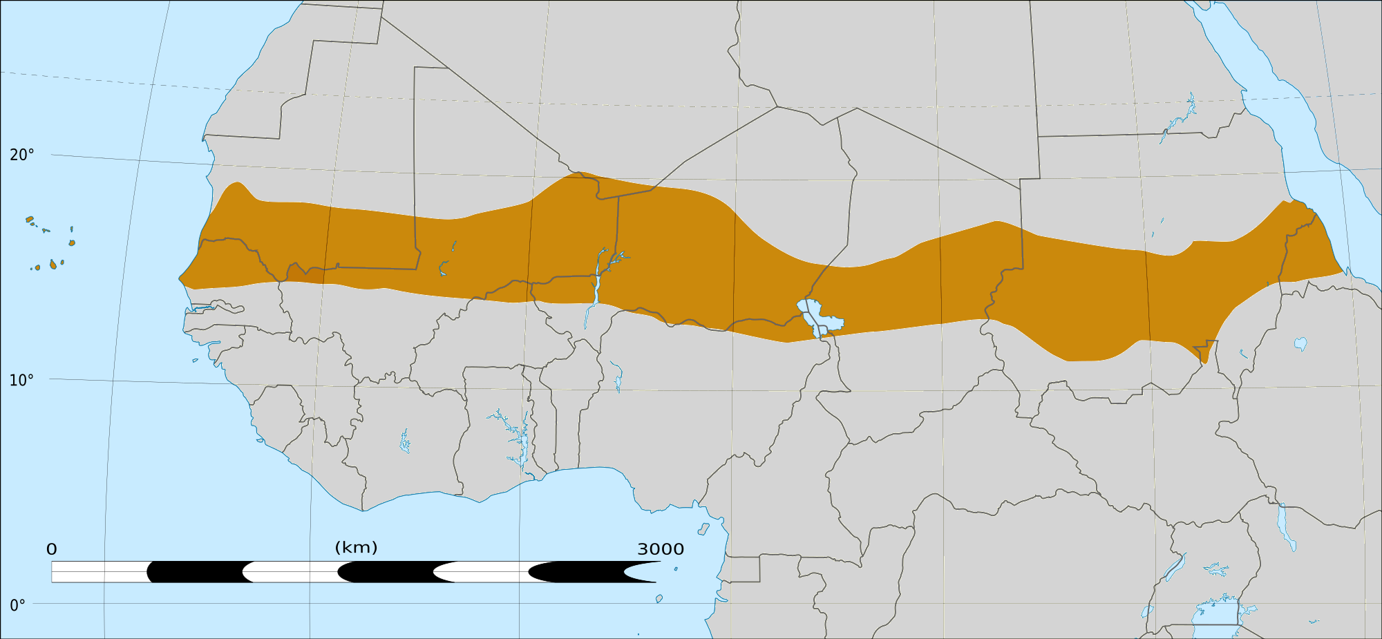
English: Map of Africa, with the Sahel highlighted in orange. This is roughly the African land area between the lines of 200mm (north) and 600mm (south) mean 20th century annual rainfall. This is limited to land areas directly to the south of the Sahara desert and including the islands of Cape Verde, but not including other areas in Africa with the same rainfall statistics. This is one, but not the only, definition of the Sahel region.
วันที่
20 กุมภาพันธ์ พ.ศ. 2552 03:54 (UTC)
แหล่งที่มา
Felix Koenig: "created/photographed by myself (based on the existing blank map of Africa)"
Photographer/illustrator: Felix Koenig (King)Blank map of Africa Map_sahel.jpg
Alemannisch ∙ العربية ∙ беларуская (тарашкевіца) ∙ български ∙ বাংলা ∙ català ∙ нохчийн ∙ čeština ∙ dansk ∙ Deutsch ∙ Ελληνικά ∙ English ∙ British English ∙ Esperanto ∙ español ∙ eesti ∙ euskara ∙ فارسی ∙ suomi ∙ français ∙ Frysk ∙ galego ∙ עברית ∙ hrvatski ∙ magyar ∙ հայերեն ∙ Bahasa Indonesia ∙ Ido ∙ italiano ∙ 日本語 ∙ ქართული ∙ 한국어 ∙ lietuvių ∙ македонски ∙ മലയാളം ∙ Bahasa Melayu ∙ norsk bokmål ∙ Plattdüütsch ∙ Nederlands ∙ norsk nynorsk ∙ norsk ∙ occitan ∙ polski ∙ português ∙ português do Brasil ∙ română ∙ русский ∙ sicilianu ∙ Scots ∙ slovenčina ∙ slovenščina ∙ српски / srpski ∙ svenska ∙ தமிழ் ∙ ไทย ∙ Türkçe ∙ татарча/tatarça ∙ українська ∙ vèneto ∙ Tiếng Việt ∙ 中文(简体) ∙ 中文(繁體) ∙ +/−
ภาพนี้ ได้รับการปรับแต่งภาพ ซึ่งหมายความว่าจะได้รับการเปลี่ยนแปลงภาพต่างจากต้นฉบับ การปรับปรุง: Reproduced Sahel boundary from Map sahel.jpg on png map, cropped. ต้นฉบับสามารถดูได้ที่นี่: BlankMap-Africa2.png. ปรับแต่งภาพโดย T L Miles.
This file is licensed under the Creative Commons Attribution-Share Alike 4.0 International, 3.0 Unported, 2.5 Generic, 2.0 Generic and 1.0 Generic license.
{{Information |Description=*Description: A map of Africa: the Sahel highlighted in orange. Note, this is ROUGHLY the African land area between the lines of 200mm (north) and 600mm (south) mean 20th century annual rainfall. This is limited to land areas d
ไฟล, sahel, africa, rough, ไฟล, ประว, ไฟล, หน, าท, ภาพน, การใช, ไฟล, วนกลาง, อม, ลเก, ยวก, บภาพขนาดของต, วอย, างน, กเซล, ความละเอ, ยดอ, กเซล, กเซล, กเซล, กเซล, ภาพท, ความละเอ, ยดส, งกว, 8206, กเซล, ขนาดไฟล, โลไบต, ชน, ดไมม, image, ปภาพหร, อไฟล, เส, ยงน, นฉบ, บ. ifl prawtiifl hnathimiphaphni karichiflswnklang khxmulekiywkbphaphkhnadkhxngtwxyangni 800 370 phikesl khwamlaexiydxun 320 148 phikesl 640 296 phikesl 1 024 474 phikesl 2 000 925 phikesl duphaphthimikhwamlaexiydsungkwa 8206 2 000 925 phikesl khnadifl 291 kiolibt chnidimm image png rupphaphhruxiflesiyngni tnchbbxyuthi khxmmxns raylaexiyddanlang epnkhxkhwamthiaesdngphlcak ifltnchbbinkhxmmxns khxmmxnsepnewbistinokhrngkarsahrbekbrwbrwmsuxesri thi khunsamarthchwyid This file requires updating because south soudan In doing so you could add a timestamp to the file Please notify the uploader with code subst update note 1 File Sahel Map Africa rough png 2 south soudan code khaxthibaySahel Map Africa rough png English Map of Africa with the Sahel highlighted in orange This is roughly the African land area between the lines of 200mm north and 600mm south mean 20th century annual rainfall This is limited to land areas directly to the south of the Sahara desert and including the islands of Cape Verde but not including other areas in Africa with the same rainfall statistics This is one but not the only definition of the Sahel region wnthi 20 kumphaphnth ph s 2552 03 54 UTC aehlngthima Felix Koenig created photographed by myself based on the existing blank map of Africa Photographer illustrator Felix Koenig King Blank map of Africa Map sahel jpg BlankMap Africa2 pngphusrangsrrkh Map sahel jpg King BlankMap Africa2 png Sadalmelikewxrchnxun phaphnimiphaphinrupaebbewketxr SVG hakphaph SVG thaihkaraesdngphldikwa hnathiichphaphnikhwrepliynipichphaph SVG aethn File Sahel Map Africa rough png File Sahel Map Africa rough svg sahrbkhxmulephimetimekiywkbphaphewketxr duthi karepliynipichphaph SVG inkhxmmxnsnxkcaknisamarthduephimetimekiywkb khxmulekiywkbkarrxngrbphaph SVG sahrbsxftaewrmiediywiki id inphasaxunAlemannisch العربية belaruskaya tarashkevica blgarski ব ল catala nohchijn cestina dansk Deutsch Ellhnika English British English Esperanto espanol eesti euskara فارسی suomi francais Frysk galego עברית hrvatski magyar հայերեն Bahasa Indonesia Ido italiano 日本語 ქართული 한국어 lietuviu makedonski മലയ ള Bahasa Melayu norsk bokmal Plattduutsch Nederlands norsk nynorsk norsk occitan polski portugues portugues do Brasil romană russkij sicilianu Scots slovencina slovenscina srpski srpski svenska தம ழ ithy Turkce tatarcha tatarca ukrayinska veneto Tiếng Việt 中文 简体 中文 繁體 phaphni idrbkarprbaetngphaph sunghmaykhwamwacaidrbkarepliynaeplngphaphtangcaktnchbb karprbprung Reproduced Sahel boundary from Map sahel jpg on png map cropped tnchbbsamarthduidthini BlankMap Africa2 png prbaetngphaphody T L Miles karxnuyatichsiththi khapheca inthanaphuthuxlikhsiththikhxngphaphhruxsuxni xnuyatihichphaphhruxsuxniphayitenguxnikhtxipni xnuyatihkhdlxk aeckcayaela hruxddaeprexksarniphayitenguxnikhkhxngsyyaxnuyatexksaresrikhxngknu run 1 2 hruxrunid nbcaknithixxkodymulnithisxftaewresri odyimmiswnidhamaekikh immikhxkhwampkhnaaelapkhlng saenakhxngsyyaxnuyatrwmxyuinswnchux syyaxnuyatexksaresrikhxngknuhttp www gnu org copyleft fdl html GFDL GNU Free Documentation License true trueThis file is licensed under the Creative Commons Attribution Share Alike 4 0 International 3 0 Unported 2 5 Generic 2 0 Generic and 1 0 Generic license khunsamarth thicaaebngpn thicathasaena aeckcay aelasngngandngklawtxip thicaeriyberiyngihm thicaddaeplngngandngklaw phayitenguxnikhtxipni aesdngthima khuntxngihekiyrtiecakhxngnganxyangehmaasm odyephimlingkipyngsyyaxnuyat aelarabuhakmikarepliynaeplng khunxacthaechnniidinrupaebbidkidtamkhwr aettxngimichinlksnathiaenawaphuihxnuyatsnbsnunkhunhruxkarichngankhxngkhun xnuyataebbediywkn hakkhunddaeplng epliynrup hruxtxetimnganni khuntxngichsyyaxnuyataebbediywknhruxaebbthiehmuxnkbsyyaxnuyatthiichkbnganniethannhttps creativecommons org licenses by sa 4 0 CC BY SA 4 0 Creative Commons Attribution Share Alike 4 0 true truekhunsamartheluxksyyaxnuyatdngklawtamtxngkar xnuyatihkhdlxk aeckcayaela hruxddaeprexksarniphayitenguxnikhkhxngsyyaxnuyatexksaresrikhxngknu run 1 2 hruxrunid nbcaknithixxkodymulnithisxftaewresri odyimmiswnidhamaekikh immikhxkhwampkhnaaelapkhlng saenakhxngsyyaxnuyatrwmxyuinswnchux syyaxnuyatexksaresrikhxngknuhttp www gnu org copyleft fdl html GFDL GNU Free Documentation License true truebnthukkarxphohld This image is a derivative work of the following images File Map sahel jpg licensed with GFDL 2005 05 30T17 36 46Z King 800x800 89588 Bytes one moment pleaseFile BlankMap Africa2 png licensed with Cc by sa 3 0 2 5 2 0 1 0 GFDL 2008 03 08T18 02 20Z Sadalmelik 1754x1546 51013 Bytes Information Description Blank map of Africa Source self made Date 2008 03 08 Author User Sadalmelik Sadalmelik Permission other versions Category Blank maps of Africa Uploaded with derivativeFXkhabrryayodyyxithyephimkhabrryaythrrthdediywephuxkhyaykhwamwaiflnimixairixethmthiaesdngxyuiniflniprakxbdwysthanalikhsiththimilikhsiththisyyaxnuyatCreative Commons Attribution ShareAlike 3 0 Unported xngkvsCreative Commons Attribution ShareAlike 4 0 International xngkvsCreative Commons Attribution ShareAlike 2 5 Generic xngkvsCreative Commons Attribution ShareAlike 1 0 Generic xngkvsGNU Free Documentation License version 1 2 or later xngkvsCreative Commons Attribution ShareAlike 2 0 Generic xngkvs prawtiifl khlikwnthi ewlaephuxduiflthipraktinkhnann wnthi ewlarupyxkhnadphuichkhwamehn pccubn23 15 17 minakhm 25612 000 925 291 kiolibt MaphobbyistSouth Sudan border 11 02 20 kumphaphnth 25521 384 658 29 kiolibt T L Miles Information Description Description A map of Africa the Sahel highlighted in orange Note this is ROUGHLY the African land area between the lines of 200mm north and 600mm south mean 20th century annual rainfall This is limited to land areas d hnathimiphaphni hnatxipni oyngmathiphaphni saehl karichiflswnklang wikixuntxipniichiflni karichbn af wikipedia org Sahel karichbn als wikipedia org Grosslandschaft Sudan karichbn ar wikipedia org مجاعة جفاف الساحل 2012 عملية برخان ممالك الساحل karichbn az wikipedia org Boyuk yasil sedd karichbn bcl wikipedia org Tag alang karichbn be wikipedia org Vyalikaya zyalyonaya scyana karichbn bg wikipedia org Zasushavane Masov glad karichbn bn wikipedia org ন ইজ র র ভ গ ল karichbn br wikipedia org Sahel karichbn ca wikipedia org Al Qaida del Magrib Islamic Sudan regio karichbn da wikipedia org Den store gronne mur karichbn en wikipedia org Geography of Niger Drought Famine Hunger Sahelian kingdoms Kintampo Complex 2010 Sahel famine 2012 Sahel drought Operation Barkhane Talk Sub Saharan Africa Archive 3 karichbn eu wikipedia org Sahel karichbn fa wikipedia org ساحل صحرا karichbn fi wikipedia org Sahel karichbn fi wiktionary org Sahel karichbn fr wikipedia org Sahel Utilisateur Aupirnay Brouillon Consequences de la desertification en region sahelienne karichbn fr wikinews org Afrique la faim menace 16 millions de personnes karichbn incubator wikimedia org Wp mnc ᠰᠠᡥᡝᠯ karichbn it wikipedia org Regni saheliani karichbn ja wikipedia org サヘル諸王国 karichbn ka wikipedia org საჰელი საჰელიანის იმპერია karichbn ko wikipedia org 사헬 karichbn mg wikipedia org Sahely karichbn mk wikipedia org Sahel Susha karichbn ml wikipedia org സ ഹ ൽ karichbn mr wikipedia org स ह ल karichbn no wikipedia org Den store gronne muren karichbn oc wikipedia org Sahel karichbn pnb wikipedia org ساحل karichbn pt wikipedia org Sahel karichbn ru wikipedia org Velikaya zelyonaya stena dukarichthwolkephimetimkhxngiflnikhxmulekiywkbphaph phaphnimikhxmulephimetim sungswnihymacakklxngdicitxlhruxsaeknenxrthisamarthekbkhxmuldngklawiwrwmkbphaphid thaphaphnithukprbprungaekikhhruxepliynaeplngcakedim khxmulbangxyangcayngkhngimepliynaeplngehmuxnphaphthithukprbprungaekikhnnkhwamlaexiydaenwnxn37 8 dpckhwamlaexiydaenwtng37 8 dpcaekikhphaphlasud16 46 24 thnwakhm 2560 ekhathungcak https th wikipedia org wiki ifl Sahel Map Africa rough png, wikipedia, วิกิ หนังสือ, หนังสือ, ห้องสมุด,