คำอธิบายSaint-Barthélemy Island topographic map-fr.svg
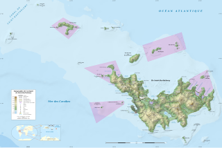
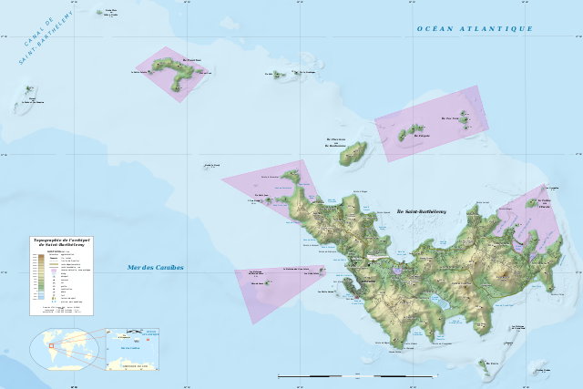
English: Topographic map in French of the Caribbean archipelago of Saint Barthélemy. Note: the shaded relief is a raster image embedded in the SVG file.
Français : Carte topographique en français de l'archipel de Saint-Barthélemy dans les Petites Antilles. Notes : le relief ombré est une image bitmap embarquée dans le fichier SVG. Une grande partie de l'île étant occupée par les habitations et les maisons étant éparses, seule la zone urbaine de Gustavia a été représentée.
UTM projection, WGS84 datum
Scales:
Shorelines (estimated): 1:200,000 (precision: 50 m)
Topography: 1:124,000 (precision: 31 m)
Bathymetry: 1:3,700,000 (precision: 925 m)
วันที่
2010-07, updated 2015-10
แหล่งที่มา
งานของตัว
Sources used:
Landsat ETM+ imagery
NASA SRTM1v3 and SRTM30 Plus data
Roads and airport: OpenStreetMap, under CC-BY-SA 2.0
Additional reference for the toponyms: Géoportail France
Reference for the nature reserve limits: Legifrance
ผู้สร้างสรรค์
Eric Gaba (Sting - fr:Sting)
การอนุญาต (การใช้ไฟล์นี้ใหม่)
Attribution and Share-Alike required
Any use of this map can be made as long as you credit me (Eric Gaba – Wikimedia Commons user: Sting) as the author, OpenStreetMap (and) contributors for the roads and airport area, and distribute the copies and derivative works under the same license(s) that the one(s) stated below. A message with a reply address would also be greatly appreciated.
This map was improved or created by the Wikigraphists of the Graphic Lab (fr). You can propose images to clean up, improve, create or translate as well.
Eric Gaba (Wikimedia Commons user Sting) and OpenStreetMap (and) contributors ในฐานะผู้ถือลิขสิทธิ์ของภาพหรือสื่อนี้ อนุญาตให้ใช้ภาพหรือสื่อนี้ภายใต้เงื่อนไขต่อไปนี้
{== {{int:filedesc}} == {{Location|17|55|00|N|62|52|00|W|scale:50000}} <br/> {{Information |Description={{en|Topographic map in French of the Caribbean archipelago of Saint Barthélemy.<br/> ''Note: the shaded relief is a raster
Topographic map of the archipelago of Saint-Barthelemy, Antilles, France
ความกว้าง
2430
ความสูง
1620
มิถุนายน 02, 2023
ไฟล, saint, barthélemy, island, topographic, ไฟล, ประว, ไฟล, หน, าท, ภาพน, การใช, ไฟล, วนกลาง, อม, ลเก, ยวก, บภาพขนาดของต, วอย, าง, ของไฟล, กเซล, ความละเอ, ยดอ, กเซล, กเซล, กเซล, กเซล, กเซล, กเซล, ภาพท, ความละเอ, ยดส, งกว, 8206, ไฟล, กเซล, ขนาดไฟล, โลไบต, ปภาพ. ifl prawtiifl hnathimiphaphni karichiflswnklang khxmulekiywkbphaphkhnadkhxngtwxyang PNG nikhxngifl SVG ni 800 533 phikesl khwamlaexiydxun 320 213 phikesl 640 427 phikesl 1 024 683 phikesl 1 280 853 phikesl 2 560 1 707 phikesl 2 430 1 620 phikesl duphaphthimikhwamlaexiydsungkwa 8206 ifl SVG 2 430 1 620 phikesl khnadifl 848 kiolibt rupphaphhruxiflesiyngni tnchbbxyuthi khxmmxns raylaexiyddanlang epnkhxkhwamthiaesdngphlcak ifltnchbbinkhxmmxns khxmmxnsepnewbistinokhrngkarsahrbekbrwbrwmsuxesri thi khunsamarthchwyid khwamyx khaxthibaySaint Barthelemy Island topographic map fr svg English Topographic map in French of the Caribbean archipelago of Saint Barthelemy Note the shaded relief is a raster image embedded in the SVG file Francais nbsp Carte topographique en francais de l archipel de Saint Barthelemy dans les Petites Antilles Notes nbsp le relief ombre est une image bitmap embarquee dans le fichier SVG Une grande partie de l ile etant occupee par les habitations et les maisons etant eparses seule la zone urbaine de Gustavia a ete representee UTM projection WGS84 datum Scales Shorelines estimated 1 200 000 precision 50 m Topography 1 124 000 precision 31 m Bathymetry 1 3 700 000 precision 925 m wnthi 2010 07 updated 2015 10 aehlngthima ngankhxngtw Sources used Landsat ETM imagery NASA SRTM1v3 and SRTM30 Plus data Roads and airport OpenStreetMap under CC BY SA 2 0 Additional reference for the toponyms Geoportail France Reference for the nature reserve limits Legifrance phusrangsrrkh Eric Gaba Sting fr Sting karxnuyat karichiflniihm Attribution and Share Alike required Any use of this map can be made as long as you credit me Eric Gaba Wikimedia Commons user Sting as the author OpenStreetMap and contributors for the roads and airport area and distribute the copies and derivative works under the same license s that the one s stated below A message with a reply address would also be greatly appreciated ewxrchnxun francais original Deutsch taaehnngthitngklxng17 nbsp 55 nbsp 00 nbsp ehnux 62 nbsp 52 nbsp 00 nbsp tawntk nbsp phaphniaelaphaphxun n sthanthiediywknthi OpenStreetMap17 916667 62 866667 This map was improved or created by the Wikigraphists of the Graphic Lab fr nbsp You can propose images to clean up improve create or translate as well ifl SVG nimikhxkhwamthisamarthaeplid odyichekhruxngmuxaepbphasa SVG hruxichtwaekikh SVG idkid sahrbkhxmulephimetim duthiekiywkbkaraeplifl karxnuyatichsiththi Eric Gaba Wikimedia Commons user Sting and OpenStreetMap and contributors inthanaphuthuxlikhsiththikhxngphaphhruxsuxni xnuyatihichphaphhruxsuxniphayitenguxnikhtxipniiflnixyuphayitsyyaxnuyat khriexthifkhxmmxns aebbaesdngthima xnuyataebbediywkn 2 0 thwipkaraesdngthima Eric Gaba Wikimedia Commons user Sting and OpenStreetMap and contributorskhunsamarth thicaaebngpn thicathasaena aeckcay aelasngngandngklawtxip thicaeriyberiyngihm thicaddaeplngngandngklaw phayitenguxnikhtxipni aesdngthima khuntxngihekiyrtiecakhxngnganxyangehmaasm odyephimlingkipyngsyyaxnuyat aelarabuhakmikarepliynaeplng khunxacthaechnniidinrupaebbidkidtamkhwr aettxngimichinlksnathiaenawaphuihxnuyatsnbsnunkhunhruxkarichngankhxngkhun xnuyataebbediywkn hakkhunddaeplng epliynrup hruxtxetimnganni khuntxngichsyyaxnuyataebbediywknhruxaebbthiehmuxnkbsyyaxnuyatthiichkbnganniethannhttps creativecommons org licenses by sa 2 0 CC BY SA 2 0 Creative Commons Attribution Share Alike 2 0 true truekhabrryayodyyxithyephimkhabrryaythrrthdediywephuxkhyaykhwamwaiflnimixairixethmthiaesdngxyuiniflniprakxbdwyphusrangbangkhathiimmiixethmwikisnethschuxphusrangsrrkh Stingchuxphuichwikimiediy Stingyuxaraexl http commons wikimedia org wiki User StingsthanalikhsiththimilikhsiththisyyaxnuyatCreative Commons Attribution ShareAlike 2 0 Generic nbsp xngkvsthimakhxngiflkarsrangdngedimodyphuxpohldcoordinates of the point of view nbsp xngkvs17 55 0 001 N 62 52 0 001 W prawtiifl khlikwnthi ewlaephuxduiflthipraktinkhnann wnthi ewlarupyxkhnadphuichkhwamehn pccubn06 43 18 tulakhm 25582 430 1 620 848 kiolibt StingUsing NASA SRTM 1 topographic data 02 00 30 krkdakhm 25532 430 1 620 815 kiolibt Sting int filedesc Location 17 55 00 N 62 52 00 W scale 50000 lt br gt Information Description en Topographic map in French of the Caribbean archipelago of Saint Barthelemy lt br gt 039 039 Note the shaded relief is a raster hnathimiphaphni hnatxipni oyngmathiphaphni kustawiya aesng baretelmi karichiflswnklang wikixuntxipniichiflni karichbn af wikipedia org Sint Bartholomeus karichbn ar wikipedia org غوستافيا سانت بارتيليمي karichbn ast wikipedia org Gustavia karichbn bs wikipedia org Gustavia Sveti Bartolomej karichbn de wikipedia org Wikipedia Kartenwerkstatt Archiv 2010 08 karichbn en wikipedia org Gustavia Saint Barthelemy Saint Barthelemy Ile Fregate Ile Chevreau Nature Reserve of Saint Barthelemy La Tortue Saint Barthelemy karichbn es wikipedia org Isla La Tortue karichbn eu wikipedia org Gustavia karichbn fa wikipedia org سن بارتلمی گوستاویا karichbn fr wikipedia org Saint Barthelemy Antilles francaises Projet Cartographie Cartes standards France Utilisateur Exp JC Brouillon karichbn gl wikipedia org Gustavia karichbn hu wikipedia org Saint Barthelemy francia tengerentuli terulet karichbn id wikipedia org Gustavia karichbn incubator wikimedia org Wp kjh Gustaviya karichbn it wikipedia org Saint Barthelemy collettivita d oltremare karichbn kk wikipedia org Sen Bartelemi karichbn lt wikipedia org Sv Bartolomejaus sala karichbn nl wikipedia org Saint Barthelemy eiland karichbn pl wikipedia org Geografia Saint Barthelemy karichbn ru wikipedia org Sen Bartelemi Kariby karichbn sv wikipedia org Gustavia karichbn ta wikipedia org க ச த வ ய ச ய ன ட ப ர த த ல ம karichbn uk wikipedia org Sen Bartelemi Transport Sen Bartelmi Geografiya Sen Bartelmi karichbn ur wikipedia org گوسٹاویا karichbn vi wikipedia org Gustavia karichbn www wikidata org Q34112khxmulekiywkbphaph phaphnimikhxmulephimetim sungswnihymacakklxngdicitxlhruxsaeknenxrthisamarthekbkhxmuldngklawiwrwmkbphaphid thaphaphnithukprbprungaekikhhruxepliynaeplngcakedim khxmulbangxyangcayngkhngimepliynaeplngehmuxnphaphthithukprbprungaekikhnnchuxeruxngsnTopographic map of the archipelago of Saint Barthelemy Antilles Francekhwamkwang2430khwamsung1620 ekhathungcak https th wikipedia org wiki ifl Saint Barthelemy Island topographic map fr svg, wikipedia, วิกิ หนังสือ, หนังสือ, ห้องสมุด,