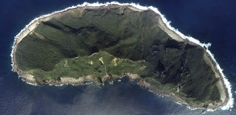
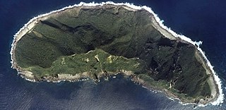
This is a composite picture of four aerial photos. Sources are [5],[6],[7], and [8]. They are all taken in 1978 by Japanese government.
the Ministry of Land, Infrastructure, Transport and Tourism of Japan ซึ่งเป็นผู้ถือลิขสิทธิ์ของไฟล์นี้ อนุญาตให้นำไฟล์นี้ไปใช้ได้ในทุกวัตถุประสงค์ รวมไปถึงการทำซ้ำ การนำไฟล์นี้ไปใช้ในการสร้างไฟล์ใหม่ การใช้เพื่อการค้า และการใช้อื่น ๆ โดยมีเงื่อนไขว่า ต้องระบุชื่อผู้ถือลิขสิทธิ์ของไฟล์นี้อย่างเหมาะสมเมื่อนำไฟล์นี้ไปใช้
This image is copyrighted by the Ministry of Land, Infrastructure, Transport and Tourism of Japan. For terms of use, see the stipulation to use of National Land Information (in Japanese) and message from MLIT (in Japanese and English). When you display this image on an article, include the following phrase in the description: "Made based on [https://mapps.gsi.go.jp/maplibSearch.do#1 National Land Image Information (Color Aerial Photographs)], Ministry of Land, Infrastructure, Transport and Tourism".
ไฟล, senkaku, uotsuri, ไฟล, ประว, ไฟล, หน, าท, ภาพน, การใช, ไฟล, วนกลาง, อม, ลเก, ยวก, บภาพขนาดของต, วอย, างน, กเซล, ความละเอ, ยดอ, กเซล, กเซล, ภาพท, ความละเอ, ยดส, งกว, 8206, กเซล, ขนาดไฟล, โลไบต, ชน, ดไมม, image, jpeg, ปภาพหร, อไฟล, เส, ยงน, นฉบ, บอย, คอมมอน. ifl prawtiifl hnathimiphaphni karichiflswnklang khxmulekiywkbphaphkhnadkhxngtwxyangni 800 390 phikesl khwamlaexiydxun 320 156 phikesl 831 405 phikesl duphaphthimikhwamlaexiydsungkwa 8206 831 405 phikesl khnadifl 208 kiolibt chnidimm image jpeg rupphaphhruxiflesiyngni tnchbbxyuthi khxmmxns raylaexiyddanlang epnkhxkhwamthiaesdngphlcak ifltnchbbinkhxmmxns khxmmxnsepnewbistinokhrngkarsahrbekbrwbrwmsuxesri thi khunsamarthchwyid 尖閣諸島魚釣島の航空写真国土交通省の4つの航空写真を合成したもの 元画像は 1 2 3 4 で すべて1978年撮影 Uotsuri jima Senkaku Islands JapanThis is a composite picture of four aerial photos Sources are 5 6 7 and 8 They are all taken in 1978 by Japanese government the Ministry of Land Infrastructure Transport and Tourism of Japan sungepnphuthuxlikhsiththikhxngiflni xnuyatihnaiflniipichidinthukwtthuprasngkh rwmipthungkarthasa karnaiflniipichinkarsrangiflihm karichephuxkarkha aelakarichxun odymienguxnikhwa txngrabuchuxphuthuxlikhsiththikhxngiflnixyangehmaasmemuxnaiflniipichkaraesdngthima Copyright c National Land Image Information Color Aerial Photographs Ministry of Land Infrastructure Transport and Tourism AttributionThis image is copyrighted by the Ministry of Land Infrastructure Transport and Tourism of Japan For terms of use see the stipulation to use of National Land Information in Japanese and message from MLIT in Japanese and English When you display this image on an article include the following phrase in the description Made based on https mapps gsi go jp maplibSearch do 1 National Land Image Information Color Aerial Photographs Ministry of Land Infrastructure Transport and Tourism khabrryayodyyxithyephimkhabrryaythrrthdediywephuxkhyaykhwamwaiflnimixaircintwetm釣魚台空照圖xahrbجزر سينكاكوixethmthiaesdngxyuiniflniprakxbdwyUotsuri shima xngkvssthanalikhsiththimilikhsiththisyyaxnuyatattribution only license xngkvsMIME type xngkvsimage jpeg prawtiifl khlikwnthi ewlaephuxduiflthipraktinkhnann wnthi ewlarupyxkhnadphuichkhwamehn pccubn23 33 25 knyayn 2548831 405 208 kiolibt Moja commonswiki 尖閣諸島魚釣島の航空写真 Uotsuri il Senkaku Islands Japan GFDL AerialPhoto MlitJp hnathimiphaphni hnatxipni oyngmathiphaphni krniphiphathhmuekaaesngkaku karichiflswnklang wikixuntxipniichiflni karichbn ar wikipedia org جزر سينكاكو karichbn arz wikipedia org جبل مونت ناراهارا جبل مونت بيوبو karichbn bg wikipedia org Senkaku karichbn bn wikipedia org স নক ক দ ব প karichbn ca wikipedia org Illes Senkaku karichbn ceb wikipedia org Uotsuri Jima karichbn cs wikipedia org Senkaku karichbn cy wikipedia org Anghydfod Ynysoedd Senkaku karichbn da wikipedia org Senkakuoerne karichbn de wikipedia org Senkaku Inseln Benutzer Diskussion Mps Archiv 2008 karichbn en wikipedia org Senkaku Islands Senkaku Islands dispute Wikipedia Main Page history 2012 August 21 Mount Narahara Mount Byōbu Okinawa karichbn es wikipedia org Islas Senkaku karichbn fa wikipedia org سنکاکو مناقشه جزایر سنکاکو karichbn fr wikipedia org Iles Senkaku Conflit territorial des iles Senkaku Mont Narahara Mont Byōbu karichbn gan wikipedia org 釣魚臺 karichbn gl wikipedia org Illas Senkaku karichbn hak wikipedia org Tiau ǹg thoi Lie t yi karichbn id wikipedia org Agustus 2012 Persengketaan Kepulauan Tiaoyutai karichbn ja wikipedia org 尖閣諸島 第三清徳丸襲撃事件 尖閣諸島戦時遭難事件 魚釣島 尖閣諸島問題 登野城尖閣 karichbn ja wikibooks org 中学校社会 地理 日本のすがた 日本の国土と範囲 karichbn ko wikipedia org 일본의 대외 관계 우오쓰리섬 뵤부산 오키나와현 나라하라산 karichbn meta wikimedia org Wiki Loves China FAQ 能传的和不能传的 User Stang Wiki Loves China FAQ 能传的和不能传的 karichbn ms wikipedia org Tuntutan bertindih mengenai Kepulauan Senkaku karichbn nl wikipedia org Senkaku eilanden karichbn nn wikipedia org Senkakuoyane karichbn no wikipedia org Senkakuoyene karichbn pl wikipedia org Wyspy Senkaku karichbn pt wikipedia org Ilhas Senkaku karichbn ro wikipedia org Arhipelagul Senkaku karichbn ru wikipedia org Problema prinadlezhnosti Senkaku dukarichthwolkephimetimkhxngiflnikhxmulekiywkbphaph phaphnimikhxmulephimetim sungswnihymacakklxngdicitxlhruxsaeknenxrthisamarthekbkhxmuldngklawiwrwmkbphaphid thaphaphnithukprbprungaekikhhruxepliynaeplngcakedim khxmulbangxyangcayngkhngimepliynaeplngehmuxnphaphthithukprbprungaekikhnn error0 ekhathungcak https th wikipedia org wiki ifl Senkaku uotsuri jpg, wikipedia, วิกิ หนังสือ, หนังสือ, ห้องสมุด,