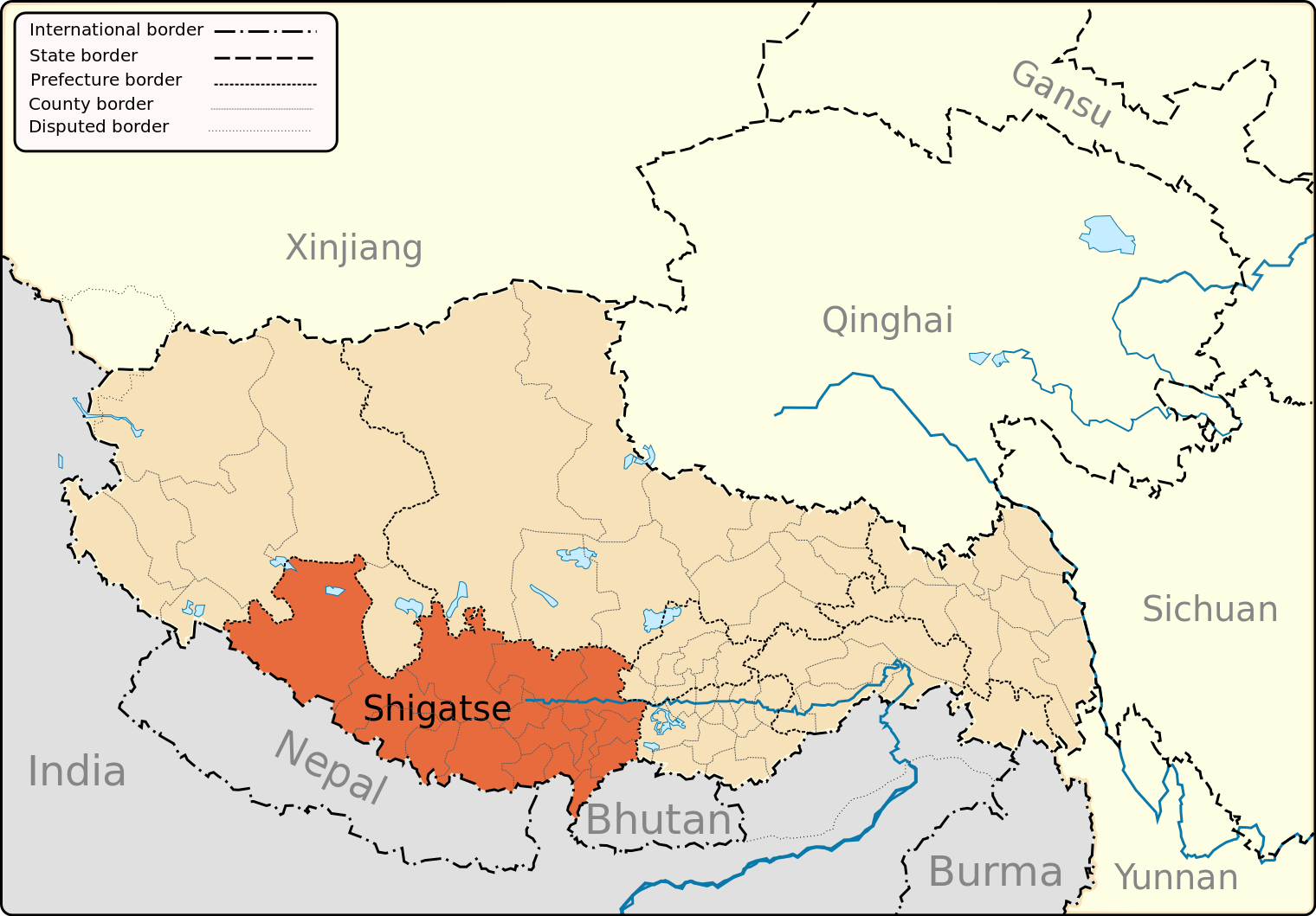
fixing Ngari/Shigatse prefecture boundary as pointed out by user:Fhah4 as per comment here: http://en.wikipedia.org/w/index.php?title=Wikipedia:Graphics_Lab/Map_workshop&diff=541288793&oldid=541266575
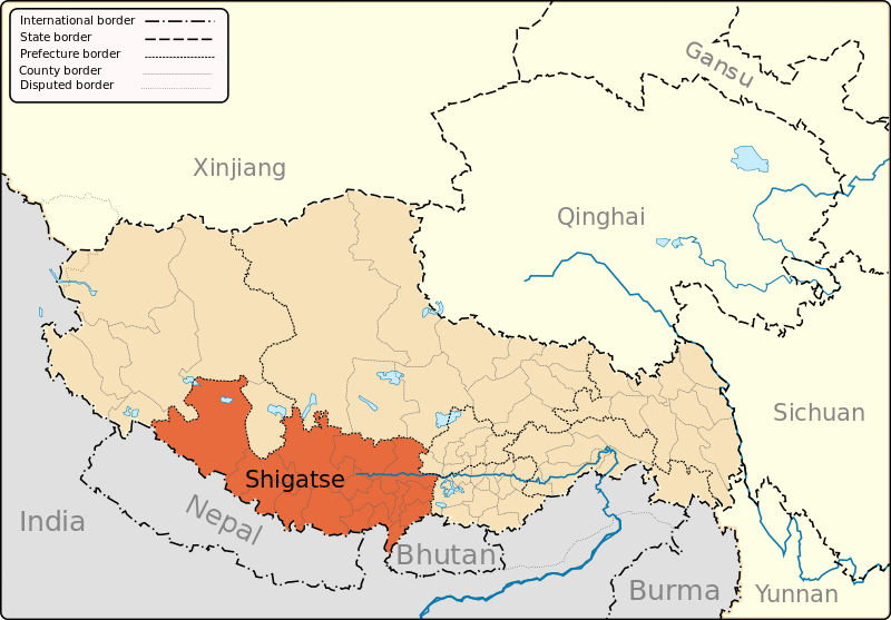
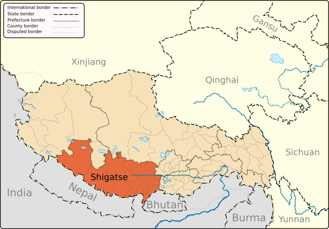
{{Information |Description={{en|1=A map of the administrative boundaries of The Tibetan Autonomous Region with Shigatse Prefecture highlighted.}} |Source=Own work by uploader |Author=Keithonearth |Date=2008-12-29 |Permission= |other_
ไฟล, shigatse, ไฟล, ประว, ไฟล, หน, าท, ภาพน, การใช, ไฟล, วนกลาง, อม, ลเก, ยวก, บภาพขนาดของต, วอย, าง, ของไฟล, กเซล, ความละเอ, ยดอ, กเซล, กเซล, กเซล, กเซล, กเซล, กเซล, ภาพท, ความละเอ, ยดส, งกว, 8206, ไฟล, กเซล, ขนาดไฟล, โลไบต, ปภาพหร, อไฟล, เส, ยงน, นฉบ, บอย, ค. ifl prawtiifl hnathimiphaphni karichiflswnklang khxmulekiywkbphaphkhnadkhxngtwxyang PNG nikhxngifl SVG ni 800 557 phikesl khwamlaexiydxun 320 223 phikesl 640 446 phikesl 1 024 713 phikesl 1 280 892 phikesl 2 560 1 784 phikesl 1 520 1 059 phikesl duphaphthimikhwamlaexiydsungkwa 8206 ifl SVG 1 520 1 059 phikesl khnadifl 183 kiolibt rupphaphhruxiflesiyngni tnchbbxyuthi khxmmxns raylaexiyddanlang epnkhxkhwamthiaesdngphlcak ifltnchbbinkhxmmxns khxmmxnsepnewbistinokhrngkarsahrbekbrwbrwmsuxesri thi khunsamarthchwyid khwamyx khaxthibayShigatse map svg English A map of the administrative boundaries of The Tibetan Autonomous Region with Shigatse Prefecture highlighted wnthi 29 thnwakhm ph s 2551aehlngthima ngankhxngtwphusrangsrrkh Keithonearthewxrchnxun TAR and neighboring Himalayan and Tibetan Plateau regions Lhasa Prefecture highlighted Nagqu aka Nakchu Prefecture highlighted Ngari aka Ali Prefecture highlighted Nyinchi Prefecture highlighted Qamdo aka Chamdo Prefecture highlighted a version for use as a locator mapSVG genesisInfoField sxrsokhdkhxng SVG nitrwcsxbthuktxngaelw iflphaphkrafiksewketxrni srangkhunodyich Inkscape or with something else karxnuyatichsiththi khapheca inthanaphuthuxlikhsiththikhxngphaphhruxsuxni xnuyatihichphaphhruxsuxniphayitenguxnikhtxipniiflnixyuphayitsyyaxnuyat khriexthifkhxmmxns aebbaesdngthima xnuyataebbediywkn 3 0 tnchbbkhunsamarth thicaaebngpn thicathasaena aeckcay aelasngngandngklawtxip thicaeriyberiyngihm thicaddaeplngngandngklaw phayitenguxnikhtxipni aesdngthima khuntxngihekiyrtiecakhxngnganxyangehmaasm odyephimlingkipyngsyyaxnuyat aelarabuhakmikarepliynaeplng khunxacthaechnniidinrupaebbidkidtamkhwr aettxngimichinlksnathiaenawaphuihxnuyatsnbsnunkhunhruxkarichngankhxngkhun xnuyataebbediywkn hakkhunddaeplng epliynrup hruxtxetimnganni khuntxngichsyyaxnuyataebbediywknhruxaebbthiehmuxnkbsyyaxnuyatthiichkbnganniethannhttps creativecommons org licenses by sa 3 0 CC BY SA 3 0 Creative Commons Attribution Share Alike 3 0 true true xnuyatihkhdlxk aeckcayaela hruxddaeprexksarniphayitenguxnikhkhxngsyyaxnuyatexksaresrikhxngknu run 1 2 hruxrunid nbcaknithixxkodymulnithisxftaewresri odyimmiswnidhamaekikh immikhxkhwampkhnaaelapkhlng saenakhxngsyyaxnuyatrwmxyuinswnchux syyaxnuyatexksaresrikhxngknuhttp www gnu org copyleft fdl html GFDL GNU Free Documentation License true truekhunsamartheluxksyyaxnuyatdngklawtamtxngkarkhabrryayodyyxithyephimkhabrryaythrrthdediywephuxkhyaykhwamwaiflnimixairixethmthiaesdngxyuiniflniprakxbdwyphusrangbangkhathiimmiixethmwikisnethschuxphuichwikimiediy Keithonearthyuxaraexl https commons wikimedia org wiki user Keithonearthchuxphusrangsrrkh KeithonearthsthanalikhsiththimilikhsiththisyyaxnuyatCreative Commons Attribution ShareAlike 3 0 Unported xngkvsGNU Free Documentation License version 1 2 or later xngkvswnthisrang wnkxtng29 thnwakhm 2008thimakhxngiflkarsrangdngedimodyphuxpohld prawtiifl khlikwnthi ewlaephuxduiflthipraktinkhnann wnthi ewlarupyxkhnadphuichkhwamehn pccubn03 17 13 minakhm 25561 520 1 059 183 kiolibt Keithonearthfixing Ngari Shigatse prefecture boundary as pointed out by user Fhah4 as per comment here http en wikipedia org w index php title Wikipedia Graphics Lab Map workshop amp diff 541288793 amp oldid 541266575 12 09 31 thnwakhm 25511 520 1 059 211 kiolibt KeithonearthChanging colour scheme to make more sense progression from non highlighted to most highlighted Category Tibet 09 26 30 thnwakhm 25511 520 1 059 211 kiolibt Keithonearth Information Description en 1 A map of the administrative boundaries of The Tibetan Autonomous Region with Shigatse Prefecture highlighted Source Own work by uploader Author Keithonearth Date 2008 12 29 Permission other hnathimiphaphni hnatxipni oyngmathiphaphni sikaec karichiflswnklang wikixuntxipniichiflni karichbn ar wikipedia org شيغاتسي karichbn bn wikipedia org গ ঝ স ক র ত স ব ভ গ karichbn bo wikipedia org གཞ ས ཀ ར ས ཁ ལ karichbn cdo wikipedia org Shigatse karichbn cs wikipedia org Zikace karichbn da wikipedia org Xigaze karichbn en wikipedia org Samzhubze District Shigatse Tingri town Yadong County Shelkar Phari Milarepa s Cave Nyalam Nyalam Town Nyalam County Gyantse County Zhangmu Template Xigaze Bainang County Kamba County Gyirong County Rinbung County Kangmar County Lhatse County Namling County Ngamring County Sa gya County Tingri County Xaitongmoin County Zhongba County Dinggye County Saga County Lhatse town Bangxing Zaze Township Drakna Township Congdu Nailung Township Parjang Township Raka Tibet Ramba Township Sengli Co Namling Manmogang Monastery Saga Tibet Jiesa Lake Dajia Lake Taruo Lake Renqingxiubu Lake Ang Laren Lake dukarichthwolkephimetimkhxngiflnikhxmulekiywkbphaph phaphnimikhxmulephimetim sungswnihymacakklxngdicitxlhruxsaeknenxrthisamarthekbkhxmuldngklawiwrwmkbphaphid thaphaphnithukprbprungaekikhhruxepliynaeplngcakedim khxmulbangxyangcayngkhngimepliynaeplngehmuxnphaphthithukprbprungaekikhnnkhwamkwang1520 4525khwamsung1059 4189 ekhathungcak https th wikipedia org wiki ifl Shigatse map svg, wikipedia, วิกิ หนังสือ, หนังสือ, ห้องสมุด,