รูปภาพหรือไฟล์เสียงนี้ ต้นฉบับอยู่ที่ คอมมอนส์ รายละเอียดด้านล่าง เป็นข้อความที่แสดงผลจาก ไฟล์ต้นฉบับในคอมมอนส์ คอมมอนส์เป็นเว็บไซต์ในโครงการสำหรับเก็บรวบรวมสื่อเสรี ที่ คุณสามารถช่วยได้
ความย่อ คำอธิบายSimeulue Topography.png Topographic map of Simeulue, Indonesia. Created with GMT from SRTM data. วันที่ 3 กันยายน พ.ศ. 2550 แหล่งที่มา งานของตัว ผู้สร้างสรรค์ Sadalmelik
การอนุญาตใช้สิทธิ ข้าพเจ้า ในฐานะผู้ถือลิขสิทธิ์ของภาพหรือสื่อนี้ อนุญาตให้ใช้ภาพหรือสื่อนี้ภายใต้เงื่อนไขต่อไปนี้
อนุญาตให้คัดลอก แจกจ่ายและ/หรือดัดแปรเอกสารนี้ภายใต้เงื่อนไขของสัญญาอนุญาตเอกสารเสรีของกนู รุ่น 1.2 หรือรุ่นใด ๆ นับจากนี้ที่ออกโดยมูลนิธิซอฟต์แวร์เสรี โดยไม่มีส่วนใดห้ามแก้ไข ไม่มีข้อความปกหน้าและปกหลัง สำเนาของสัญญาอนุญาตรวมอยู่ในส่วนชื่อ สัญญาอนุญาตเอกสารเสรีของกนู http://www.gnu.org/copyleft/fdl.html GFDL GNU Free Documentation License true true
ไฟล์นี้อยู่ภายใต้สัญญาอนุญาตครีเอทีฟคอมมอนส์ รุ่นแสดงที่มา-อนุญาตแบบเดียวกัน 3.0 ต้นฉบับ, 2.5 ทั่วไป, 2.0 ทั่วไป และ 1.0 ทั่วไป
คุณสามารถ: ที่จะแบ่งปัน – ที่จะทำสำเนา แจกจ่าย และส่งงานดังกล่าวต่อไปที่จะเรียบเรียงใหม่ – ที่จะดัดแปลงงานดังกล่าว ภายใต้เงื่อนไขต่อไปนี้: แสดงที่มา – คุณต้องให้เกียรติเจ้าของงานอย่างเหมาะสม โดยเพิ่มลิงก์ไปยังสัญญาอนุญาต และระบุหากมีการเปลี่ยนแปลง คุณอาจทำเช่นนี้ได้ในรูปแบบใดก็ได้ตามควร แต่ต้องไม่ใช่ในลักษณะที่แนะว่าผู้ให้อนุญาตสนับสนุนคุณหรือการใช้งานของคุณอนุญาตแบบเดียวกัน – หากคุณดัดแปลง เปลี่ยนรูป หรือต่อเติมงานนี้ คุณต้องใช้สัญญาอนุญาตแบบเดียวกันหรือแบบที่เหมือนกับสัญญาอนุญาตที่ใช้กับงานนี้เท่านั้น https://creativecommons.org/licenses/by-sa/3.0 CC BY-SA 3.0 Creative Commons Attribution-Share Alike 3.0 true true คุณสามารถเลือกสัญญาอนุญาตดังกล่าวตามต้องการ
ไทย เพิ่มคำบรรยายทรรทัดเดียวเพื่อขยายความว่าไฟล์นี้มีอะไร
ประวัติไฟล์ คลิกวันที่/เวลาเพื่อดูไฟล์ที่ปรากฏในขณะนั้น
วันที่/เวลา รูปย่อ ขนาด ผู้ใช้ ความเห็น ปัจจุบัน 14:56, 3 กันยายน 2550 2,014 × 1,788 (568 กิโลไบต์) Sadalmelik {{Information |Description=Topographic map of Simeulue, Indonesia. Created with GMT from SRTM data. |Source=self-made |Date=Sep 3, 2007 |Author= Sadalmelik }} Category:Maps of Indonesia Category:Topographic maps of Asia
หน้าที่มีภาพนี้ หน้าต่อไปนี้ โยงมาที่ภาพนี้:
การใช้ไฟล์ส่วนกลาง วิกิอื่นต่อไปนี้ใช้ไฟล์นี้:
การใช้บน en.wikiversity.org Draft:Original research/Geographic coordinates Pole star project/Equatorials Teupah Selatan Teupah Barat Simeulue Tengah
ไฟล, simeulue, topography, ไฟล, ประว, ไฟล, หน, าท, ภาพน, การใช, ไฟล, วนกลางขนาดของต, วอย, างน, กเซล, ความละเอ, ยดอ, กเซล, กเซล, กเซล, กเซล, กเซล, ภาพท, ความละเอ, ยดส, งกว, 8206, กเซล, ขนาดไฟล, โลไบต, ชน, ดไมม, image, ปภาพหร, อไฟล, เส, ยงน, นฉบ, บอย, คอมมอนส, ร. ifl prawtiifl hnathimiphaphni karichiflswnklangkhnadkhxngtwxyangni 675 599 phikesl khwamlaexiydxun 270 240 phikesl 541 480 phikesl 865 768 phikesl 1 153 1 024 phikesl 2 014 1 788 phikesl duphaphthimikhwamlaexiydsungkwa 8206 2 014 1 788 phikesl khnadifl 568 kiolibt chnidimm image png rupphaphhruxiflesiyngni tnchbbxyuthi khxmmxns raylaexiyddanlang epnkhxkhwamthiaesdngphlcak ifltnchbbinkhxmmxns khxmmxnsepnewbistinokhrngkarsahrbekbrwbrwmsuxesri thi khunsamarthchwyid khwamyx khaxthibaySimeulue Topography png Topographic map of Simeulue Indonesia Created with GMT from SRTM data wnthi 3 knyayn ph s 2550 aehlngthima ngankhxngtw phusrangsrrkh Sadalmelik karxnuyatichsiththi khapheca inthanaphuthuxlikhsiththikhxngphaphhruxsuxni xnuyatihichphaphhruxsuxniphayitenguxnikhtxipni xnuyatihkhdlxk aeckcayaela hruxddaeprexksarniphayitenguxnikhkhxngsyyaxnuyatexksaresrikhxngknu run 1 2 hruxrunid nbcaknithixxkodymulnithisxftaewresri odyimmiswnidhamaekikh immikhxkhwampkhnaaelapkhlng saenakhxngsyyaxnuyatrwmxyuinswnchux syyaxnuyatexksaresrikhxngknuhttp www gnu org copyleft fdl html GFDL GNU Free Documentation License true trueiflnixyuphayitsyyaxnuyatkhriexthifkhxmmxns runaesdngthima xnuyataebbediywkn 3 0 tnchbb 2 5 thwip 2 0 thwip aela 1 0 thwipkhunsamarth thicaaebngpn thicathasaena aeckcay aelasngngandngklawtxip thicaeriyberiyngihm thicaddaeplngngandngklaw phayitenguxnikhtxipni aesdngthima khuntxngihekiyrtiecakhxngnganxyangehmaasm odyephimlingkipyngsyyaxnuyat aelarabuhakmikarepliynaeplng khunxacthaechnniidinrupaebbidkidtamkhwr aettxngimichinlksnathiaenawaphuihxnuyatsnbsnunkhunhruxkarichngankhxngkhun xnuyataebbediywkn hakkhunddaeplng epliynrup hruxtxetimnganni khuntxngichsyyaxnuyataebbediywknhruxaebbthiehmuxnkbsyyaxnuyatthiichkbnganniethannhttps creativecommons org licenses by sa 3 0 CC BY SA 3 0 Creative Commons Attribution Share Alike 3 0 true truekhunsamartheluxksyyaxnuyatdngklawtamtxngkarkhabrryayodyyxithyephimkhabrryaythrrthdediywephuxkhyaykhwamwaiflnimixairixethmthiaesdngxyuiniflniprakxbdwyphusrangbangkhathiimmiixethmwikisnethschuxphusrangsrrkh Sadalmelikchuxphuichwikimiediy Sadalmelikyuxaraexl http commons wikimedia org wiki User SadalmeliksthanalikhsiththimilikhsiththisyyaxnuyatGNU Free Documentation License version 1 2 or lateral nbsp xngkvsCreative Commons Attribution ShareAlike 1 0 Generic nbsp xngkvsCreative Commons Attribution ShareAlike 2 0 Generic nbsp xngkvsCreative Commons Attribution ShareAlike 2 5 Generic nbsp xngkvsCreative Commons Attribution ShareAlike 3 0 Unported nbsp xngkvswnthisrang wnkxtng3 knyayn 2007thimakhxngiflkarsrangdngedimodyphuxpohld prawtiifl khlikwnthi ewlaephuxduiflthipraktinkhnann wnthi ewlarupyxkhnadphuichkhwamehn pccubn14 56 3 knyayn 25502 014 1 788 568 kiolibt Sadalmelik Information Description Topographic map of Simeulue Indonesia Created with GMT from SRTM data Source self made Date Sep 3 2007 Author Sadalmelik Category Maps of Indonesia Category Topographic maps of Asia hnathimiphaphni hnatxipni oyngmathiphaphni ekaasiemxluewx karichiflswnklang wikixuntxipniichiflni karichbn ar wikipedia org جزيرة سيمولو karichbn bg wikipedia org Simeulue karichbn de wikipedia org Simeulue karichbn en wikipedia org Simeulue karichbn en wikiversity org Draft Original research Geographic coordinates Pole star project Equatorials karichbn eo wikipedia org Simeulue karichbn es wikipedia org Kabupaten Simeulue karichbn fr wikipedia org Simeulue karichbn gl wikipedia org Illa Simeulue karichbn ms wikipedia org Pulau Simeulue karichbn nl wikipedia org Simeulue Timur Teupah Selatan Teupah Barat Simeulue Tengah karichbn no wikipedia org Simeulue karichbn pl wikipedia org Simeulue karichbn pt wikipedia org Simeulue karichbn ru wikipedia org Simyolue ostrov karichbn zh wikipedia org 锡默卢岛 ekhathungcak https th wikipedia org wiki ifl Simeulue Topography png, wikipedia, วิกิ หนังสือ, หนังสือ, ห้องสมุด,
บทความ , อ่าน, ดาวน์โหลด, ฟรี, ดาวน์โหลดฟรี, mp3, วิดีโอ, mp4, 3gp, jpg, jpeg, gif, png, รูปภาพ, เพลง, เพลง, หนัง, หนังสือ, เกม, เกม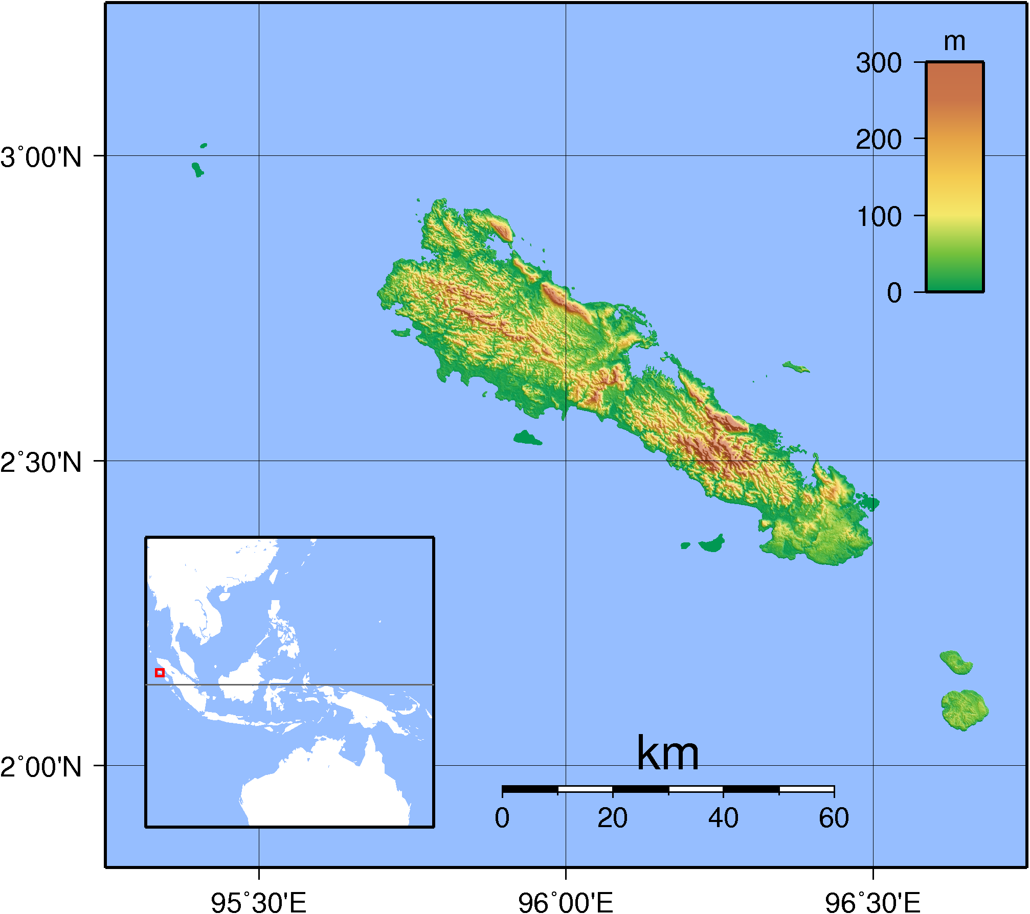