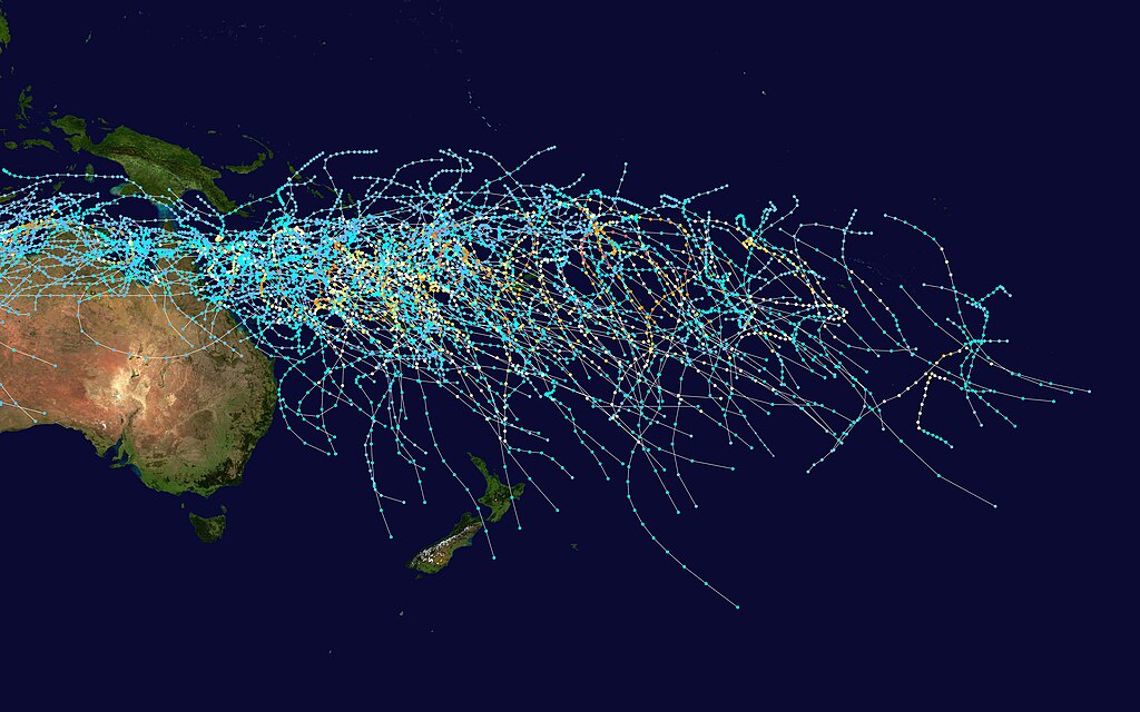
This map shows the tracks of all Tropical cyclones in the South Pacific Ocean from 1980 to 2005. The points show the locations of the storms at six-hourly intervals and use the color scheme shown above from Saffir-Simpson Hurricane Scale.
การอนุญาตใช้สิทธิ
Created using User:jdorje/Tracks by Nilfanion on 2007-02-19. Background image from Image:Whole world - land and oceans.jpg (NASA). The best track information is from the Joint Typhoon Warning Center.[1]
ไฟล, south, pacific, cyclone, tracks, 1980, 2005, ไฟล, ประว, ไฟล, หน, าท, ภาพน, การใช, ไฟล, วนกลาง, อม, ลเก, ยวก, บภาพขนาดของต, วอย, างน, กเซล, ความละเอ, ยดอ, กเซล, กเซล, กเซล, กเซล, กเซล, กเซล, ภาพท, ความละเอ, ยดส, งกว, 8206, กเซล, ขนาดไฟล, เมกะไบต, ชน, ดไมม,. ifl prawtiifl hnathimiphaphni karichiflswnklang khxmulekiywkbphaphkhnadkhxngtwxyangni 800 500 phikesl khwamlaexiydxun 320 200 phikesl 640 400 phikesl 1 024 640 phikesl 1 280 800 phikesl 2 560 1 600 phikesl 6 400 4 000 phikesl duphaphthimikhwamlaexiydsungkwa 8206 6 400 4 000 phikesl khnadifl 2 27 emkaibt chnidimm image jpeg rupphaphhruxiflesiyngni tnchbbxyuthi khxmmxns raylaexiyddanlang epnkhxkhwamthiaesdngphlcak ifltnchbbinkhxmmxns khxmmxnsepnewbistinokhrngkarsahrbekbrwbrwmsuxesri thi khunsamarthchwyid khwamyx Saffir Simpson Hurricane Scale TD TS 1 2 3 4 5 This map shows the tracks of all Tropical cyclones in the South Pacific Ocean from 1980 to 2005 The points show the locations of the storms at six hourly intervals and use the color scheme shown above from Saffir Simpson Hurricane Scale karxnuyatichsiththi Created using User jdorje Tracks by Nilfanion on 2007 02 19 Background image from Image Whole world land and oceans jpg NASA The best track information is from the Joint Typhoon Warning Center 1 Public domain Public domain false false khapheca phuthuxlikhsiththiinnganni khxmxbnganihepnsatharnsmbti prakasnimiphlthwolkinbangpraeths karkrathadngklawxacimsamarththaidtamkdhmaykhaphecaxnuyatihthukkhnmisiththiinkarichiflniinthukehtuphlkarich odyimmimienguxnikh ewnaetkdhmayimxnuyatihthaechnnnkhabrryayodyyxithyephimkhabrryaythrrthdediywephuxkhyaykhwamwaiflnimixairixethmthiaesdngxyuiniflniprakxbdwysthanalikhsiththicopyrighted dedicated to the public domain by copyright holder nbsp xngkvssyyaxnuyatreleased into the public domain by the copyright holder nbsp xngkvsMIME type nbsp xngkvsimage jpeg prawtiifl khlikwnthi ewlaephuxduiflthipraktinkhnann wnthi ewlarupyxkhnadphuichkhwamehn pccubn04 23 28 kumphaphnth 25506 400 4 000 2 27 emkaibt Nilfanion Description align align right border 0 cellspacing 0 cellpadding 0 style background transparent text align center colspan 7 nowrap nowrap lt small gt Saffir Simpson Hurricane Scale lt small gt s hnathimiphaphni hnatxipni oyngmathiphaphni aexngphayuhmunekhtrxn karichiflswnklang wikixuntxipniichiflni karichbn en wikipedia org Tropical cyclone basins karichbn fr wikipedia org Nomenclature des cyclones tropicaux Alerte cyclonique karichbn id wikipedia org Siklon tropis Pasifik Selatan karichbn ms wikipedia org Siklon tropika karichbn pt wikipedia org Bacia de formacao de ciclones tropicais Avisos e alertas de ciclone tropical karichbn ru wikipedia org Bassejny tropicheskih ciklonov karichbn uk wikipedia org Basejni tropichnih cikloniv karichbn zh wikipedia org 南太平洋熱帶氣旋季 熱帶氣旋洋盆khxmulekiywkbphaph phaphnimikhxmulephimetim sungswnihymacakklxngdicitxlhruxsaeknenxrthisamarthekbkhxmuldngklawiwrwmkbphaphid thaphaphnithukprbprungaekikhhruxepliynaeplngcakedim khxmulbangxyangcayngkhngimepliynaeplngehmuxnphaphthithukprbprungaekikhnn error0 ekhathungcak https th wikipedia org wiki ifl South Pacific cyclone tracks 1980 2005 jpg, wikipedia, วิกิ หนังสือ, หนังสือ, ห้องสมุด,