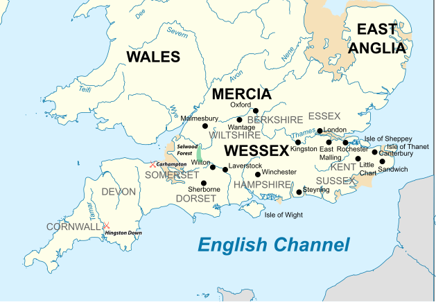
English: Map of the Southern British Isles during the 9th century
วันที่
แหล่งที่มา
งานของตัว Incorporates elements of this map. Locations are based on the Ordinance Survey Atlas of Great Britain, apart from Selwood Forest, which is taken from Barbara Yorke, Wessex in the Early Middle Ages, 1995, p. 23, ISBN 0 7185 1856 X
ผู้สร้างสรรค์
Philg88; Attribution: Wikimedia Foundation (www.wikimedia.org)
{{Information |Description ={{en|1=Map of the Southern British Isles during the 9th century}} |Source ={{own}} Incorporates elements of [https://commons.wikimedia.org/wiki/File:British_Isles_10th_century.svg this map] |Author =[[User...
ไฟล, southern, british, isles, century, ไฟล, ประว, ไฟล, หน, าท, ภาพน, การใช, ไฟล, วนกลาง, อม, ลเก, ยวก, บภาพขนาดของต, วอย, าง, ของไฟล, กเซล, ความละเอ, ยดอ, กเซล, กเซล, กเซล, กเซล, กเซล, ภาพท, ความละเอ, ยดส, งกว, 8206, ไฟล, กเซล, ขนาดไฟล, เมกะไบต, ปภาพหร, อไฟล,. ifl prawtiifl hnathimiphaphni karichiflswnklang khxmulekiywkbphaphkhnadkhxngtwxyang PNG nikhxngifl SVG ni 629 435 phikesl khwamlaexiydxun 320 221 phikesl 640 443 phikesl 1 024 708 phikesl 1 280 885 phikesl 2 560 1 770 phikesl duphaphthimikhwamlaexiydsungkwa 8206 ifl SVG 629 435 phikesl khnadifl 1 95 emkaibt rupphaphhruxiflesiyngni tnchbbxyuthi khxmmxns raylaexiyddanlang epnkhxkhwamthiaesdngphlcak ifltnchbbinkhxmmxns khxmmxnsepnewbistinokhrngkarsahrbekbrwbrwmsuxesri thi khunsamarthchwyid khaxthibaySouthern British Isles 9th century svg English Map of the Southern British Isles during the 9th centurywnthi 19 krkdakhm ph s 2558aehlngthima ngankhxngtw Incorporates elements of this map Locations are based on the Ordinance Survey Atlas of Great Britain apart from Selwood Forest which is taken from Barbara Yorke Wessex in the Early Middle Ages 1995 p 23 ISBN 0 7185 1856 Xphusrangsrrkh Philg88 Attribution Wikimedia Foundation www wikimedia org karxnuyat karichiflniihm i sxrsokhdkhxng SVG nitrwcsxbthuktxngaelw iflphaphkrafiksewketxrimidrabukartrwcody W3C ni srangkhunodyich Adobe Illustrator iflnixyuphayitsyyaxnuyatkhriexthifkhxmmxns run aesdngthima 4 0 nanachatikhunsamarth thicaaebngpn thicathasaena aeckcay aelasngngandngklawtxip thicaeriyberiyngihm thicaddaeplngngandngklaw phayitenguxnikhtxipni aesdngthima khuntxngihekiyrtiecakhxngnganxyangehmaasm odyephimlingkipyngsyyaxnuyat aelarabuhakmikarepliynaeplng khunxacthaechnniidinrupaebbidkidtamkhwr aettxngimichinlksnathiaenawaphuihxnuyatsnbsnunkhunhruxkarichngankhxngkhunhttps creativecommons org licenses by 4 0 CC BY 4 0 Creative Commons Attribution 4 0 true truekhabrryayodyyxithyephimkhabrryaythrrthdediywephuxkhyaykhwamwaiflnimixairxngkvsMap of the Southern British Isles during the 9th centuryixethmthiaesdngxyuiniflniprakxbdwybritichixlsrachxanackrewsesksrachxanackremxresiyrachxanackrxistaexngekliypraethsewlsphusrangbangkhathiimmiixethmwikisnethschuxphusrangsrrkh Philg88chuxphuichwikimiediy Philg88yuxaraexl http commons wikimedia org wiki User Philg88sthanalikhsiththimilikhsiththisyyaxnuyatCreative Commons Attribution 4 0 International xngkvswnthisrang wnkxtng19 krkdakhm 2015thimakhxngiflkarsrangdngedimodyphuxpohld prawtiifl khlikwnthi ewlaephuxduiflthipraktinkhnann wnthi ewlarupyxkhnadphuichkhwamehn pccubn00 30 20 krkdakhm 2558629 435 1 95 emkaibt Philg88User requested modifications 23 00 19 krkdakhm 2558629 435 1 65 emkaibt Philg88 Information Description en 1 Map of the Southern British Isles during the 9th century Source own Incorporates elements of https commons wikimedia org wiki File British Isles 10th century svg this map Author User hnathimiphaphni hnatxipni oyngmathiphaphni exethlwulf kstriyaehngewsesks karichiflswnklang wikixuntxipniichiflni karichbn bn wikipedia org ওয স ক স karichbn cs wikipedia org Wessex karichbn el wikipedia org E8elgoylf toy Oyesse3 karichbn en wikipedia org Wessex AEthelred I of Wessex AEthelwulf King of Wessex Carhampton Battle of Hingston Down Wikipedia Graphics Lab Map workshop Archive Jul 2015 karichbn es wikipedia org Ethelwulfo de Wessex Reino de Wessex Batalla de Hingston Down karichbn he wikipedia org קרב הינגסטון דון karichbn ja wikipedia org ヒングストン ダウンの戦い karichbn ko wikipedia org 웨식스 왕국 karichbn ms wikipedia org Wessex karichbn tr wikipedia org Wessex Kralligi I Ethelred Wessex krali karichbn zh wikipedia org 威塞克斯王國 埃塞尔雷德 威塞克斯 khxmulekiywkbphaph phaphnimikhxmulephimetim sungswnihymacakklxngdicitxlhruxsaeknenxrthisamarthekbkhxmuldngklawiwrwmkbphaphid thaphaphnithukprbprungaekikhhruxepliynaeplngcakedim khxmulbangxyangcayngkhngimepliynaeplngehmuxnphaphthithukprbprungaekikhnnkhwamkwang628 902pxkhwamsung434 979px ekhathungcak https th wikipedia org wiki ifl Southern British Isles 9th century svg, wikipedia, วิกิ หนังสือ, หนังสือ, ห้องสมุด,