This map was improved or created by the Wikigraphists of the Graphic Lab (fr). You can propose images to clean up, improve, create or translate as well.
กอปปีเลฟต์: งานศิลปะนี้ไม่มีมูลค่า คุณสามารถแจกจ่ายและ/หรือแก้ไขได้ภายใต้เงื่อนไข Free Art License คุณสามารถพบตัวอย่างของสัญญาอนุญาตนี้ได้บนไซต์ Copyleft Attitude รวมทั้งบนไซต์อื่น ๆ ด้วย http://artlibre.org/licence/lal/enFALFree Art Licensefalsetrue
This file is licensed under the Creative Commons Attribution-Share Alike 4.0 International, 3.0 Unported, 2.5 Generic, 2.0 Generic and 1.0 Generic license.
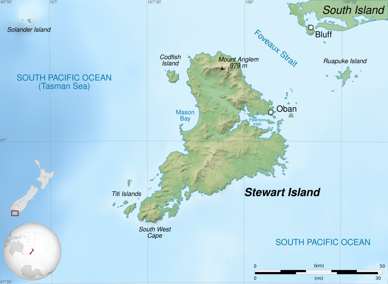
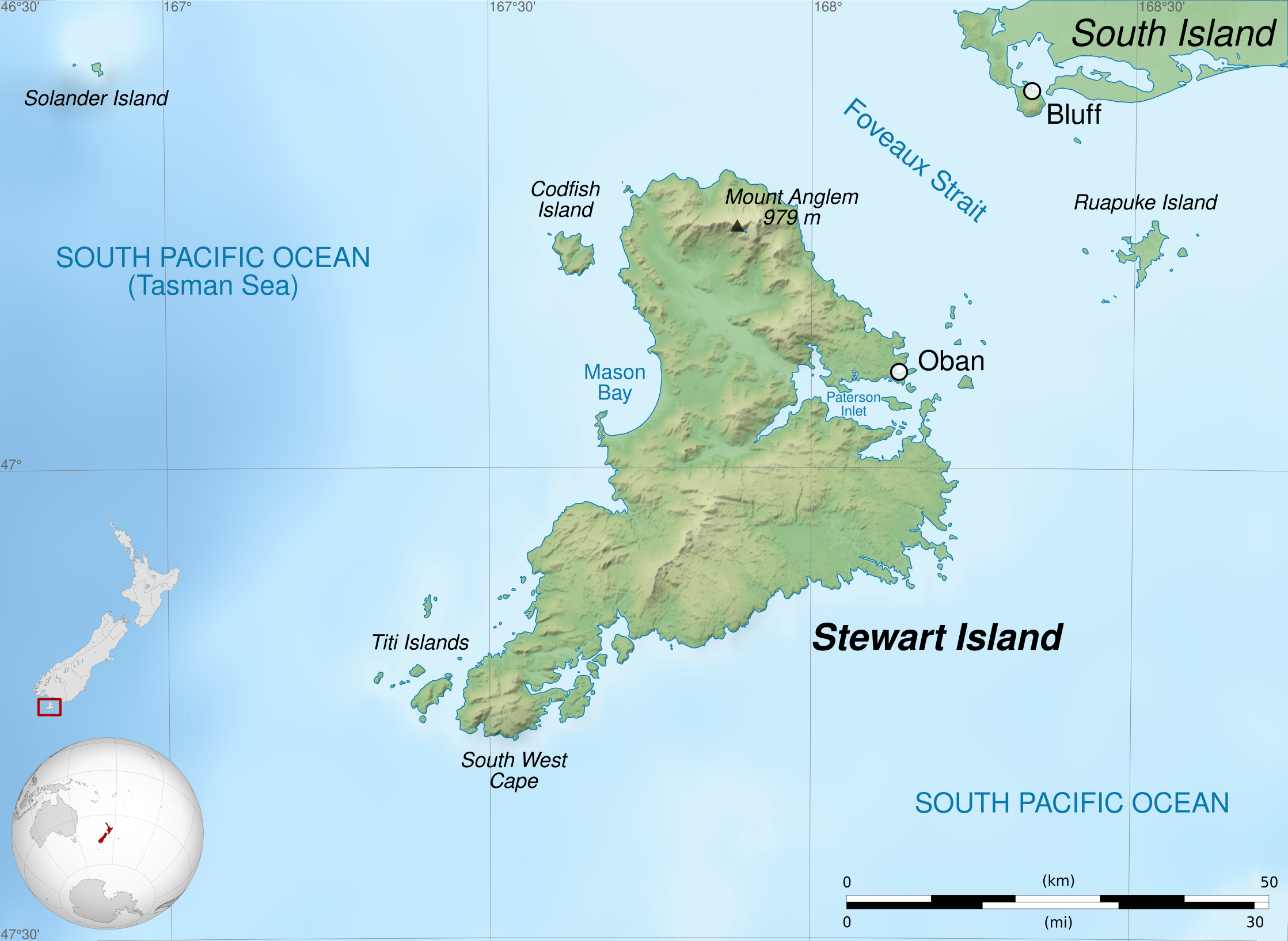
== {{int:filedesc}} == {{Information |Description={{Multilingual description |en=Map of en:Stewart Island / Rakiura, New Zealand. * Altitude levels: 50 m, 125, 250, 500, etc. (same for bathymetry). * Projection: New Zealand Geodetic Datum 2000 ; GRS
Map of Stewart island, or Rakiura, south of New Zealand
ความกว้าง
2237
ความสูง
1635
มกราคม 26, 2024
ไฟล, stewart, island, ไฟล, ประว, ไฟล, หน, าท, ภาพน, การใช, ไฟล, วนกลาง, อม, ลเก, ยวก, บภาพขนาดของต, วอย, าง, ของไฟล, กเซล, ความละเอ, ยดอ, กเซล, กเซล, กเซล, กเซล, กเซล, กเซล, ภาพท, ความละเอ, ยดส, งกว, 8206, ไฟล, กเซล, ขนาดไฟล, เมกะไบต, ปภาพหร, อไฟล, เส, ยงน, นฉ. ifl prawtiifl hnathimiphaphni karichiflswnklang khxmulekiywkbphaphkhnadkhxngtwxyang PNG nikhxngifl SVG ni 800 585 phikesl khwamlaexiydxun 320 234 phikesl 640 468 phikesl 1 024 748 phikesl 1 280 936 phikesl 2 560 1 871 phikesl 2 237 1 635 phikesl duphaphthimikhwamlaexiydsungkwa 8206 ifl SVG 2 237 1 635 phikesl khnadifl 1 7 emkaibt rupphaphhruxiflesiyngni tnchbbxyuthi khxmmxns raylaexiyddanlang epnkhxkhwamthiaesdngphlcak ifltnchbbinkhxmmxns khxmmxnsepnewbistinokhrngkarsahrbekbrwbrwmsuxesri thi khunsamarthchwyid khwamyx khaxthibayStewart Island map en svg English Map of Stewart Island Rakiura New Zealand Altitude levels 50 m 125 250 500 etc same for bathymetry Projection New Zealand Geodetic Datum 2000 nbsp GRS80 datum Standard meridian 167 45 E True scale parallel 47 S Geographic limits of the map West 166 75 E East 168 75 E North 46 5 S South 47 5 SFrancais Carte de l ile Stewart au sud de la Nouvelle Zelande Niveaux d altitudes nbsp 50 m 125 250 500 etc Idem pour la bathymetrie Projection nbsp New Zealand Geodetic Datum 2000 nbsp systeme geodesique GRS80 Meridien de reference nbsp 167 45 E Parallele de reference nbsp 47 S Limites geographiques de la carte nbsp Ouest nbsp 166 75 E Est nbsp 168 75 E Nord nbsp 46 5 S Sud nbsp 47 5 S wnthi 27 emsayn ph s 2554 aehlngthima ngankhxngtw English Shorelines NASA Shuttle Radar Topography Mission SWBD public domain nbsp Topography NASA Shuttle Radar Topography Mission SRTM3 v 2 public domain nbsp Bathymetry NGDC ETOPO1 public domain nbsp NZL orthographic NaturalEarth svg by Gringer under licence Public Domain nbsp New Zealand location map svg by NordNordWest under licence GFDL or CC BY SA 3 0Francais Trace des cotes nbsp NASA Shuttle Radar Topography Mission SWBD domaine public nbsp Topographie nbsp NASA Shuttle Radar Topography Mission SRTM3 v 2 domaine public nbsp Bathymetrie nbsp NGDC ETOPO1 domaine public nbsp NZL orthographic NaturalEarth svg de Gringer sous licence domaine public nbsp New Zealand location map svg de NordNordWest sous licence GFDL ou CC BY SA 3 0 phusrangsrrkh Semhur talk ewxrchnxun francais makedonski cestinakaraesdngthima caepntxngmitamsyyaxnuyat InfoField c Semhur nbsp nbsp Wikimedia Commons nbsp nbsp CC BY SA 4 0 or Free Art LicenseInfoField c Semhur nbsp nbsp Wikimedia Commons SVGInfoField nbsp W3C validity not checked nbsp iflphaphkrafiksewketxrimidrabukartrwcody W3C nbsp ni srangkhunodyich nbsp Inkscape ifl SVG nimikhxkhwamthisamarthaeplid odyichekhruxngmuxaepbphasa SVG hruxichtwaekikh SVG idkid sahrbkhxmulephimetim duthiekiywkbkaraeplifl Graphic LabInfoFieldThis map was improved or created by the Wikigraphists of the Graphic Lab fr nbsp You can propose images to clean up improve create or translate as well taaehnngthitngklxng47 nbsp 00 nbsp 00 nbsp it 167 nbsp 45 nbsp 00 nbsp tawnxxk nbsp nbsp nbsp phaphniaelaphaphxun n sthanthiediywknthi OpenStreetMap 47 000000 167 750000 karxnuyatichsiththi khapheca inthanaphuthuxlikhsiththikhxngphaphhruxsuxni xnuyatihichphaphhruxsuxniphayitenguxnikhtxipni kxppielft ngansilpaniimmimulkha khunsamarthaeckcayaela hruxaekikhidphayitenguxnikh Free Art License khunsamarthphbtwxyangkhxngsyyaxnuyatniidbnist Copyleft Attitude rwmthngbnistxun dwy http artlibre org licence lal en FAL Free Art License false trueThis file is licensed under the Creative Commons Attribution Share Alike 4 0 International 3 0 Unported 2 5 Generic 2 0 Generic and 1 0 Generic license khunsamarth thicaaebngpn thicathasaena aeckcay aelasngngandngklawtxip thicaeriyberiyngihm thicaddaeplngngandngklaw phayitenguxnikhtxipni aesdngthima khuntxngihekiyrtiecakhxngnganxyangehmaasm odyephimlingkipyngsyyaxnuyat aelarabuhakmikarepliynaeplng khunxacthaechnniidinrupaebbidkidtamkhwr aettxngimichinlksnathiaenawaphuihxnuyatsnbsnunkhunhruxkarichngankhxngkhun xnuyataebbediywkn hakkhunddaeplng epliynrup hruxtxetimnganni khuntxngichsyyaxnuyataebbediywknhruxaebbthiehmuxnkbsyyaxnuyatthiichkbnganniethannhttps creativecommons org licenses by sa 4 0 CC BY SA 4 0 Creative Commons Attribution Share Alike 4 0 true truekhunsamartheluxksyyaxnuyatdngklawtamtxngkarkhabrryayodyyxithyephimkhabrryaythrrthdediywephuxkhyaykhwamwaiflnimixairixethmthiaesdngxyuiniflniprakxbdwyphusrangbangkhathiimmiixethmwikisnethschuxphusrangsrrkh Semhuryuxaraexl https commons wikimedia org wiki user S C3 A9mhurchuxphuichwikimiediy SemhursthanalikhsiththimilikhsiththisyyaxnuyatFree Art LicenseCreative Commons Attribution ShareAlike 2 5 Generic nbsp xngkvsCreative Commons Attribution ShareAlike 1 0 Generic nbsp xngkvsCreative Commons Attribution ShareAlike 4 0 International nbsp xngkvsCreative Commons Attribution ShareAlike 3 0 Unported nbsp xngkvsCreative Commons Attribution ShareAlike 2 0 Generic nbsp xngkvsthimakhxngiflkarsrangdngedimodyphuxpohldwnthisrang wnkxtng27 emsayn 2011coordinates of the point of view nbsp xngkvs47 S 168 Eheading nbsp xngkvs 0 xngsaMIME type nbsp xngkvsimage svg xml prawtiifl khlikwnthi ewlaephuxduiflthipraktinkhnann wnthi ewlarupyxkhnadphuichkhwamehn pccubn04 39 4 kumphaphnth 25632 237 1 635 1 7 emkaibt SemhurCorrect scale 14 58 2 mithunayn 25572 237 1 635 1 7 emkaibt SemhurValid SVG 04 22 28 emsayn 25542 237 1 635 1 7 emkaibt Semhur int filedesc Information Description Multilingual description en Map of en Stewart Island Rakiura New Zealand Altitude levels 50 m 125 250 500 etc same for bathymetry Projection New Zealand Geodetic Datum 2000 GRS hnathimiphaphni hnatxipni oyngmathiphaphni ekaascwrt karichiflswnklang wikixuntxipniichiflni karichbn ast wikipedia org Estrechu de Foveaux karichbn bn wikipedia org ব শ ব র প রণ ল সম হ র ত ল ক karichbn br wikipedia org Rakiura karichbn de wikipedia org Titi Muttonbird Islands karichbn en wikipedia org Codfish Island Whenua Hou Stewart Island karichbn fa wikipedia org جزیره استوارت karichbn fi wikipedia org Stewartinsaari karichbn gl wikipedia org Illa Stewart karichbn hu wikipedia org Stewart sziget karichbn kw wikipedia org Edhen dhineyj karichbn lt wikipedia org Stiuarto sala Kodfisas sala Ruapuke karichbn lv wikipedia org Stjuarta sala karichbn ml wikipedia org സ റ റ യ വ ർട ട ഐലന റ karichbn nl wikipedia org Stewarteiland karichbn no wikipedia org Stewart Island karichbn pl wikipedia org Wyspa Stewart karichbn simple wikipedia org Stewart Island karichbn sl wikipedia org Stewartov otok Rakiura karichbn sv wikipedia org William W Stewart karichbn ta wikipedia org ஸ ட வர ட த வ karichbn uk wikipedia org Styuart ostriv karichbn vi wikipedia org Đảo Stewart karichbn zh wikipedia org 福沃海峡khxmulekiywkbphaph phaphnimikhxmulephimetim sungswnihymacakklxngdicitxlhruxsaeknenxrthisamarthekbkhxmuldngklawiwrwmkbphaphid thaphaphnithukprbprungaekikhhruxepliynaeplngcakedim khxmulbangxyangcayngkhngimepliynaeplngehmuxnphaphthithukprbprungaekikhnnchuxeruxngsnMap of Stewart island or Rakiura south of New Zealandkhwamkwang2237khwamsung1635 ekhathungcak https th wikipedia org wiki ifl Stewart Island map en svg, wikipedia, วิกิ หนังสือ, หนังสือ, ห้องสมุด,