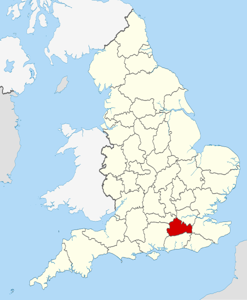
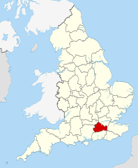
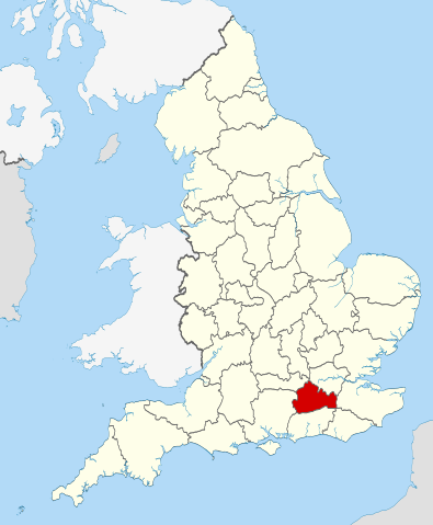
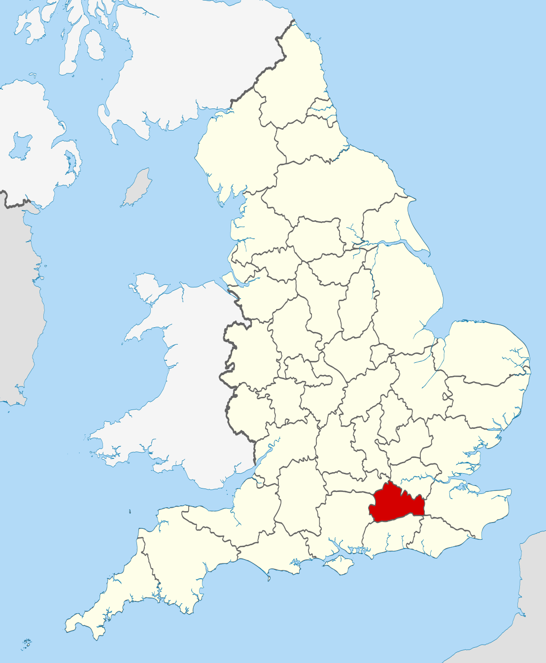
This is one of the images forming part of the Valued image set: Locator maps of the Ceremonial counties of England on Wikimedia Commons. The image set has been assessed under the valued image set criteria and is considered the most valued set on Commons within the scope:
Locator maps of the Ceremonial counties of England
You can see its nomination at Commons:Valued image candidates/Locator maps of English ceremonial counties.
== Summary == {{Information |Description=Location of the ceremonial county of Surrey within England. |Source=Ordnance Survey [https://www.ordnancesurvey.co.uk/opendatadownload/products.html OpenData]: *County boundaries
ไฟล, surrey, locator, 2010, ไฟล, ประว, ไฟล, หน, าท, ภาพน, การใช, ไฟล, วนกลาง, อม, ลเก, ยวก, บภาพขนาดของต, วอย, าง, ของไฟล, กเซล, ความละเอ, ยดอ, กเซล, กเซล, กเซล, กเซล, กเซล, กเซล, ภาพท, ความละเอ, ยดส, งกว, 8206, ไฟล, กเซล, ขนาดไฟล, โลไบต, ปภาพหร, อไฟล, เส, ยงน. ifl prawtiifl hnathimiphaphni karichiflswnklang khxmulekiywkbphaphkhnadkhxngtwxyang PNG nikhxngifl SVG ni 494 600 phikesl khwamlaexiydxun 198 240 phikesl 395 480 phikesl 633 768 phikesl 843 1 024 phikesl 1 687 2 048 phikesl 1 108 1 345 phikesl duphaphthimikhwamlaexiydsungkwa 8206 ifl SVG 1 108 1 345 phikesl khnadifl 302 kiolibt rupphaphhruxiflesiyngni tnchbbxyuthi khxmmxns raylaexiyddanlang epnkhxkhwamthiaesdngphlcak ifltnchbbinkhxmmxns khxmmxnsepnewbistinokhrngkarsahrbekbrwbrwmsuxesri thi khunsamarthchwyid khwamyx khaxthibaySurrey UK locator map 2010 svg Location of the ceremonial county of Surrey within England wnthi 23 phvscikayn ph s 2553 aehlngthima Ordnance Survey OpenData County boundaries and GB coastline National Geospatial Intelligence Agency Irish French and Isle of Man coastlines Lough Neagh and Irish border phusrangsrrkh Nilfanion karxnuyatichsiththi khapheca inthanaphuthuxlikhsiththikhxngphaphhruxsuxni xnuyatihichphaphhruxsuxniphayitenguxnikhtxipniiflnixyuphayitsyyaxnuyat khriexthifkhxmmxns aebbaesdngthima xnuyataebbediywkn 3 0 tnchbbkhunsamarth thicaaebngpn thicathasaena aeckcay aelasngngandngklawtxip thicaeriyberiyngihm thicaddaeplngngandngklaw phayitenguxnikhtxipni aesdngthima khuntxngihekiyrtiecakhxngnganxyangehmaasm odyephimlingkipyngsyyaxnuyat aelarabuhakmikarepliynaeplng khunxacthaechnniidinrupaebbidkidtamkhwr aettxngimichinlksnathiaenawaphuihxnuyatsnbsnunkhunhruxkarichngankhxngkhun xnuyataebbediywkn hakkhunddaeplng epliynrup hruxtxetimnganni khuntxngichsyyaxnuyataebbediywknhruxaebbthiehmuxnkbsyyaxnuyatthiichkbnganniethannhttps creativecommons org licenses by sa 3 0 CC BY SA 3 0 Creative Commons Attribution Share Alike 3 0 true true xnuyatihkhdlxk aeckcayaela hruxddaeprexksarniphayitenguxnikhkhxngsyyaxnuyatexksaresrikhxngknu run 1 2 hruxrunid nbcaknithixxkodymulnithisxftaewresri odyimmiswnidhamaekikh immikhxkhwampkhnaaelapkhlng saenakhxngsyyaxnuyatrwmxyuinswnchux syyaxnuyatexksaresrikhxngknuhttp www gnu org copyleft fdl html GFDL GNU Free Documentation License true truekhunsamartheluxksyyaxnuyatdngklawtamtxngkar This is one of the images forming part of the Valued image set Locator maps of the Ceremonial counties of England on Wikimedia Commons The image set has been assessed under the valued image set criteria and is considered the most valued set on Commons within the scope Locator maps of the Ceremonial counties of England You can see its nomination at Commons Valued image candidates Locator maps of English ceremonial counties khabrryayodyyxithyephimkhabrryaythrrthdediywephuxkhyaykhwamwaiflnimixairixethmthiaesdngxyuiniflniprakxbdwyphusrangbangkhathiimmiixethmwikisnethschuxphuichwikimiediy Nilfanionyuxaraexl https commons wikimedia org wiki user Nilfanionchuxphusrangsrrkh NilfanionsthanalikhsiththimilikhsiththisyyaxnuyatGNU Free Documentation License version 1 2 or later nbsp xngkvsCreative Commons Attribution ShareAlike 3 0 Unported nbsp xngkvswnthisrang wnkxtng23 phvscikayn 2010 prawtiifl khlikwnthi ewlaephuxduiflthipraktinkhnann wnthi ewlarupyxkhnadphuichkhwamehn pccubn05 45 24 phvscikayn 25531 108 1 345 302 kiolibt Nilfanion Summary Information Description Location of the ceremonial county of Surrey within England Source Ordnance Survey https www ordnancesurvey co uk opendatadownload products html OpenData County boundaries hnathimiphaphni hnatxipni oyngmathiphaphni esxrriy karichiflswnklang wikixuntxipniichiflni karichbn af wikipedia org Surrey karichbn ar wikipedia org سري مقاطعة karichbn arz wikipedia org ساررى karichbn ast wikipedia org Surrey karichbn azb wikipedia org ساری اینگیلیس karichbn az wikipedia org Surrey karichbn be tarask wikipedia org Sarej karichbn be wikipedia org Surej karichbn bg wikipedia org Sri Yugoiztochna Angliya karichbn ca wikipedia org Surrey Llista de comtats cerimonials d Anglaterra karichbn ceb wikipedia org Surrey kondado karichbn cs wikipedia org Surrey karichbn el wikipedia org Sarrey karichbn en wikipedia org Surrey Winkworth Arboretum Witley Common Farley Green Surrey Ribsden Holt Template Surrey geo stub Winterfold Forest The Rye brook Savill Garden Wey South Path Ramster Blackheath Common Sandhills Surrey Molesey Reservoirs Knight Reservoir Sunnyside Reservoir Salfords and Sidlow Woolmer Hill Frimley Lodge Park Grade I listed buildings in Surrey Coldharbour Surrey Mogador Surrey Haste Hill Penton Hook Marina Mole Gap Trail Rushmoor Surrey Grade II listed buildings in Surrey 1977 Surrey County Council election Template Infobox English county testcases Truss s Island Chitty s Common Milton Heath and The Nower karichbn eo wikipedia org Surrey karichbn es wikipedia org Surrey Anexo Condados ceremoniales de Inglaterra dukarichthwolkephimetimkhxngiflnikhxmulekiywkbphaph phaphnimikhxmulephimetim sungswnihymacakklxngdicitxlhruxsaeknenxrthisamarthekbkhxmuldngklawiwrwmkbphaphid thaphaphnithukprbprungaekikhhruxepliynaeplngcakedim khxmulbangxyangcayngkhngimepliynaeplngehmuxnphaphthithukprbprungaekikhnnkhwamkwang1108khwamsung1345 ekhathungcak https th wikipedia org wiki ifl Surrey UK locator map 2010 svg, wikipedia, วิกิ หนังสือ, หนังสือ, ห้องสมุด,