azərbaycanca ∙ Deutsch (Sie-Form) ∙ čeština ∙ Deutsch ∙ sicilianu ∙ italiano ∙ русский ∙ română ∙ português ∙ English ∙ magyar ∙ Nederlands ∙ slovenščina ∙ polski ∙ latviešu ∙ македонски ∙ español ∙ فارسی ∙ français ∙ suomi ∙ עברית ∙ Plattdüütsch ∙ ქართული ∙ հայերեն ∙ বাংলা ∙ ไทย ∙ 日本語 ∙ 中文 ∙ 中文(简体) ∙ 中文(繁體) ∙ العربية ∙ +/−
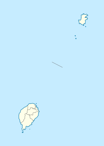
{{int:filedesc}} {{Information |Description= {{de|Positionskarte von São Tomé and Príncipe}} Quadratische Plattkarte. Geographische Begrenzung der Karte: * N: 1.9° N * S: 0.2° S * W: 6.2° E * O: 7.7° E {{en|Location
ไฟล, são, tomé, príncipe, location, ไฟล, ประว, ไฟล, หน, าท, ภาพน, การใช, ไฟล, วนกลาง, อม, ลเก, ยวก, บภาพขนาดของต, วอย, าง, ของไฟล, กเซล, ความละเอ, ยดอ, กเซล, กเซล, กเซล, กเซล, กเซล, กเซล, ภาพท, ความละเอ, ยดส, งกว, 8206, ไฟล, กเซล, ขนาดไฟล, โลไบต, ปภาพหร, อไฟล,. ifl prawtiifl hnathimiphaphni karichiflswnklang khxmulekiywkbphaphkhnadkhxngtwxyang PNG nikhxngifl SVG ni 428 599 phikesl khwamlaexiydxun 171 240 phikesl 343 480 phikesl 549 768 phikesl 732 1 024 phikesl 1 464 2 048 phikesl 496 694 phikesl duphaphthimikhwamlaexiydsungkwa 8206 ifl SVG 496 694 phikesl khnadifl 10 kiolibt rupphaphhruxiflesiyngni tnchbbxyuthi khxmmxns raylaexiyddanlang epnkhxkhwamthiaesdngphlcak ifltnchbbinkhxmmxns khxmmxnsepnewbistinokhrngkarsahrbekbrwbrwmsuxesri thi khunsamarthchwyid khwamyx khaxthibaySao Tome and Principe location map svg Deutsch Positionskarte von Sao Tome and Principe Quadratische Plattkarte Geographische Begrenzung der Karte N 1 9 N S 0 2 S W 6 2 E O 7 7 E English Location map of Sao Tome and Principe Equirectangular projection Geographic limits of the map N 1 9 N S 0 2 S W 6 2 E E 7 7 E wnthi 5 tulakhm ph s 2552 aehlngthima ngankhxngtw using United States National Imagery and Mapping Agency data phusrangsrrkh NordNordWest karxnuyat karichiflniihm khapheca inthanaphuthuxlikhsiththikhxngphaphhruxsuxni xnuyatihichphaphhruxsuxniphayitenguxnikhtxipniiflnixyuphayitsyyaxnuyat khriexthifkhxmmxns aebbaesdngthima xnuyataebbediywkn 3 0 tnchbbkhunsamarth thicaaebngpn thicathasaena aeckcay aelasngngandngklawtxip thicaeriyberiyngihm thicaddaeplngngandngklaw phayitenguxnikhtxipni aesdngthima khuntxngihekiyrtiecakhxngnganxyangehmaasm odyephimlingkipyngsyyaxnuyat aelarabuhakmikarepliynaeplng khunxacthaechnniidinrupaebbidkidtamkhwr aettxngimichinlksnathiaenawaphuihxnuyatsnbsnunkhunhruxkarichngankhxngkhun xnuyataebbediywkn hakkhunddaeplng epliynrup hruxtxetimnganni khuntxngichsyyaxnuyataebbediywknhruxaebbthiehmuxnkbsyyaxnuyatthiichkbnganniethannhttps creativecommons org licenses by sa 3 0 CC BY SA 3 0 Creative Commons Attribution Share Alike 3 0 true true aephnthinithuksranghruxphthnakhuncak Kartenwerkstatt hxngptibtikaraephnthi khxngwikiphiediyphasaeyxrmn sungkhunsamarthesnxaephnthiephuxphthnaidechnediywkn azerbaycanca nbsp Deutsch Sie Form nbsp cestina nbsp Deutsch nbsp sicilianu nbsp italiano nbsp russkij nbsp romană nbsp portugues nbsp English nbsp magyar nbsp Nederlands nbsp slovenscina nbsp polski nbsp latviesu nbsp makedonski nbsp espanol nbsp فارسی nbsp francais nbsp suomi nbsp עברית nbsp Plattduutsch nbsp ქართული nbsp հայերեն nbsp ব ল nbsp ithy nbsp 日本語 nbsp 中文 nbsp 中文 简体 nbsp 中文 繁體 nbsp العربية nbsp khabrryayodyyxithyephimkhabrryaythrrthdediywephuxkhyaykhwamwaiflnimixairixethmthiaesdngxyuiniflniprakxbdwyphusrangbangkhathiimmiixethmwikisnethschuxphusrangsrrkh NordNordWestchuxphuichwikimiediy NordNordWestyuxaraexl http commons wikimedia org wiki User NordNordWeststhanalikhsiththimilikhsiththisyyaxnuyatCreative Commons Attribution ShareAlike 3 0 Unported nbsp xngkvsthimakhxngiflkarsrangdngedimodyphuxpohldwnthisrang wnkxtng5 tulakhm 2009 prawtiifl khlikwnthi ewlaephuxduiflthipraktinkhnann wnthi ewlarupyxkhnadphuichkhwamehn pccubn02 01 28 phvscikayn 2563496 694 10 kiolibt NordNordWestmore exact 22 25 17 mithunayn 2557496 694 9 kiolibt NordNordWestcorr 02 40 6 tulakhm 2552496 694 13 kiolibt NordNordWest int filedesc Information Description de Positionskarte von Sao Tome and Principe Quadratische Plattkarte Geographische Begrenzung der Karte N 1 9 N S 0 2 S W 6 2 E O 7 7 E en Location hnathimiphaphni hnatxipni oyngmathiphaphni esatuaem karichiflswnklang wikixuntxipniichiflni karichbn af wikipedia org Sjabloon Liggingkaart Sao Tome en Principe karichbn am wikipedia org መለጠፊያ Location map ሳን ቶሜ እና ፕሪንሲፔ karichbn an wikipedia org Plantilla Mapa de localizacion Sant Tome y Prencipe Sant Tome karichbn ar wikipedia org قالب خريطة مواقع ساو توميه وبرينسيب karichbn ast wikipedia org Santu Tome capital Aeropuertu Internacional de Santu Tome Aeropuertu de Principe Modulu Minimapa data Santu Tome y Principe Modulu Minimapa data Santu Tome y Principe usu Islla de Santu Tome karichbn ba wikipedia org San Tome ҡala Ҡalyp PozKarta San Tome һәm Prinsipi karichbn be tarask wikipedia org San Tame gorad Shablyon Lyakalizacyjnaya mapa San Tame i Prynsypi karichbn be wikipedia org San Tame Shablon Na karce San Tame i Prynsipi Santu Antonyu karichbn bg wikipedia org Shablon PK Sao Tome i Prinsipi karichbn bn wikipedia org ভ গ ল ক আয তন অন য য স র বভ ম র ষ ট র ও ন র ভরশ ল অঞ চলসম হ র ত ল ক মড উল অবস থ ন ম নচ ত র উপ ত ত স উ ত ম ও প র ন স প মড উল অবস থ ন ম নচ ত র উপ ত ত স উ ত ম ও প র ন স প নথ karichbn bs wikipedia org Sablon Lokacijska karta Sveti Toma i Princip karichbn ca wikipedia org Aeroport de Principe Aeroport Internacional de Sao Tome Modul Location map data Sao Tome i Principe Modul Location map data Sao Tome i Principe us karichbn ceb wikipedia org Plantilya Location map Sao Tome and Principe The Brothers San Antonio Rio Caue Salazar Binda Ponta de Santo Antonio Ponta de Santo Antonio Santo Antonio Praia das Conchas Cambuta Ponta Baleia Capitango Sao Pedro Sao Pedro Catraio Muongo Mutamba Monte Sinai Micondo Observatorio Palmira Agua Grande dukarichthwolkephimetimkhxngiflnikhxmulekiywkbphaph phaphnimikhxmulephimetim sungswnihymacakklxngdicitxlhruxsaeknenxrthisamarthekbkhxmuldngklawiwrwmkbphaphid thaphaphnithukprbprungaekikhhruxepliynaeplngcakedim khxmulbangxyangcayngkhngimepliynaeplngehmuxnphaphthithukprbprungaekikhnnkhwamkwang496 055pxkhwamsung694 486px ekhathungcak https th wikipedia org wiki ifl Sao Tome and Principe location map svg, wikipedia, วิกิ หนังสือ, หนังสือ, ห้องสมุด,