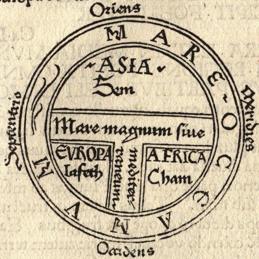
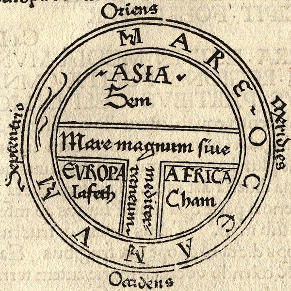
T and O style mappa mundi (map of the known world) from the first printed version of Isidorus' Etymologiae (Kraus 13). The book was written in 623 and first printed in 1472 at Augsburg by one Günther Zainer (Guntherus Ziner), Isidor's sketch thus becoming the oldest printed map of the occident.
Note: T-O-maps are typically displayed "East-up", show Jerusalem at the center and the paradise at the outmost East, balanced by the pillars of Hercules at the outmost West.
This T and O map, from the first printed version of Isidore's Etymologiae, identifies the three known continents as populated by descendants of Sem (Shem), Iafeth (Japheth) and Cham (Ham)
T and O map, from the first printed version of Isidore's Etymologiae, identifying the three known continents as populated by descendants of Sem (Shem), Iafeth (Japheth) and Cham (Ham)
ไฟล, guntherus, ziner, 1472, ไฟล, ประว, ไฟล, หน, าท, ภาพน, การใช, ไฟล, วนกลาง, อม, ลเก, ยวก, บภาพขนาดของต, วอย, างน, กเซล, ความละเอ, ยดอ, กเซล, กเซล, กเซล, ภาพท, ความละเอ, ยดส, งกว, 8206, กเซล, ขนาดไฟล, โลไบต, ชน, ดไมม, image, jpeg, ปภาพหร, อไฟล, เส, ยงน, นฉบ,. ifl prawtiifl hnathimiphaphni karichiflswnklang khxmulekiywkbphaphkhnadkhxngtwxyangni 600 600 phikesl khwamlaexiydxun 240 240 phikesl 480 480 phikesl 864 864 phikesl duphaphthimikhwamlaexiydsungkwa 8206 864 864 phikesl khnadifl 279 kiolibt chnidimm image jpeg rupphaphhruxiflesiyngni tnchbbxyuthi khxmmxns raylaexiyddanlang epnkhxkhwamthiaesdngphlcak ifltnchbbinkhxmmxns khxmmxnsepnewbistinokhrngkarsahrbekbrwbrwmsuxesri thi khunsamarthchwyid khwamyx silpin phusrangsrrkhngan Isidore of Seville khaxthibay T and O style mappa mundi map of the known world from the first printed version of Isidorus Etymologiae Kraus 13 The book was written in 623 and first printed in 1472 at Augsburg by one Gunther Zainer Guntherus Ziner Isidor s sketch thus becoming the oldest printed map of the occident Note T O maps are typically displayed East up show Jerusalem at the center and the paradise at the outmost East balanced by the pillars of Hercules at the outmost West thima phuthayphaph iflnithukaeykmacakiflxun Etimologias Mapa del Mundo Conocido jpg karxnuyatichsiththi phaphniepnphaphthiekidcakkarthasaenaphaphhruxsilpkrrmsxngmiti sungtwphaphtnchbbthithukthasannepnsatharnsmbtidwyehtuphltxipni Public domain Public domain false false nganniepnsatharnsmbti inpraethstnkaenidaelapraethsxun thirayaewlakarkhumkhrxnglikhsiththinxykwa 100 pihlngcakphusrangsrrkhnganesiychiwit nxkcaknikhunxactxngephimpaysatharnsmbtiinshrthxemrika ephuxrabuwaehtuidngannicungepnsatharnsmbtiinshrthxemrika iflniidthukrabuwaimmikhxcakdphayitkdhmaylikhsiththi rwmthungsiththithiekiywkhxngaelathiiklekhiyngknhttps creativecommons org publicdomain mark 1 0 PDM Creative Commons Public Domain Mark 1 0 false false mulnithiwikiphiediymimummxngxyangepnthangkarinkrniniwa karthasaenaphaphhruxsilpkrrmsxngmitithiepnsatharnsmbti thuxwaphaphthiidcakkarthasaenaepnsatharnsmbti karxangphlngandngklawepnnganswnbukhkhlepnkarkhdtxaenwkhidekiywkbsatharnsmbti sahrbkhxmulephimetim duthi emuxidcaichpay PD Artkarthasaenakhxngphaphnisungepnsatharnsmbti thuxidwaphaphthiekidcakkarthasaenaepnsatharnsmbtiechnkn oprdthrabwakarnaphaphniipichxacthukcakdhruxhamichinekhtxanacsalkhxngthan thngnikhunkbkdhmaythxngthinthibngkhbichinphunthinn duephimthi karnaphaphhruxsilpkrrmsxngmitiipichkhabrryayodyyxithyephimkhabrryaythrrthdediywephuxkhyaykhwamwaiflnimixairSpanish formal address This T and O map from the first printed version of Isidore s Etymologiae identifies the three known continents as populated by descendants of Sem Shem Iafeth Japheth and Cham Ham xinodniesiyT and O map from the first printed version of Isidore s Etymologiae identifying the three known continents as populated by descendants of Sem Shem Iafeth Japheth and Cham Ham ixethmthiaesdngxyuiniflniprakxbdwy prawtiifl khlikwnthi ewlaephuxduiflthipraktinkhnann wnthi ewlarupyxkhnadphuichkhwamehn pccubn05 43 19 singhakhm 2549864 864 279 kiolibt Ma xyzReverted to earlier revision 05 42 19 singhakhm 2549224 238 18 kiolibt Ma xyzReverted to earlier revision 13 34 11 singhakhm 2549864 864 279 kiolibt Leinad Z commonswikiLarger version cropped from Image T O map 1472 jpg 17 25 24 phvsphakhm 2548224 238 18 kiolibt Dbachmanndetail of Image Etymologiae Guntherus Ziner 1472 jpg PD art hnathimiphaphni hnatxipni oyngmathiphaphni aephnthirupthiaelaox karichiflswnklang wikixuntxipniichiflni karichbn ar wikipedia org معاداة السامية العرقية karichbn arz wikipedia org حاميين يافثيين karichbn ast wikipedia org Continente karichbn be wikipedia org Mappa mundi Karta T O karichbn bg wikipedia org Yafetiti karichbn bn wikipedia org ইউর প karichbn bo wikipedia org ཤར ཕ གས karichbn br wikipedia org Breizh Uhel Breizh Izel Kartennouriezh karichbn bs wikipedia org Evropa karichbn ca wikipedia org Continent Fills de Noe Semites karichbn cs wikipedia org T mapa karichbn cv wikipedia org Sim Ham Shablon Noj achisem karichbn da wikipedia org Kort geografi karichbn de wikipedia org Radkarte Himmelsrichtung Osten Alte Welt Norden Etymologiae karichbn de wikibooks org Benutzer HirnSpuk Quadriviale Kuriositaten karichbn el wikipedia org Hpeiroi karichbn en wikipedia org Christendom Cartography Europe Japheth Shem Semitic people Generations of Noah Old World T and O map Japhetites User Nurg Continent Racial antisemitism Talk Eurocentrism Continent Hamites Fantasy cartography Gunther Zainer God s Philosophers Cartographic propaganda Wikipedia Reference desk Archives Humanities 2016 November 20 dukarichthwolkephimetimkhxngiflnikhxmulekiywkbphaph phaphnimikhxmulephimetim sungswnihymacakklxngdicitxlhruxsaeknenxrthisamarthekbkhxmuldngklawiwrwmkbphaphid thaphaphnithukprbprungaekikhhruxepliynaeplngcakedim khxmulbangxyangcayngkhngimepliynaeplngehmuxnphaphthithukprbprungaekikhnn error0 ekhathungcak https th wikipedia org wiki ifl T and O map Guntherus Ziner 1472 jpg, wikipedia, วิกิ หนังสือ, หนังสือ, ห้องสมุด,