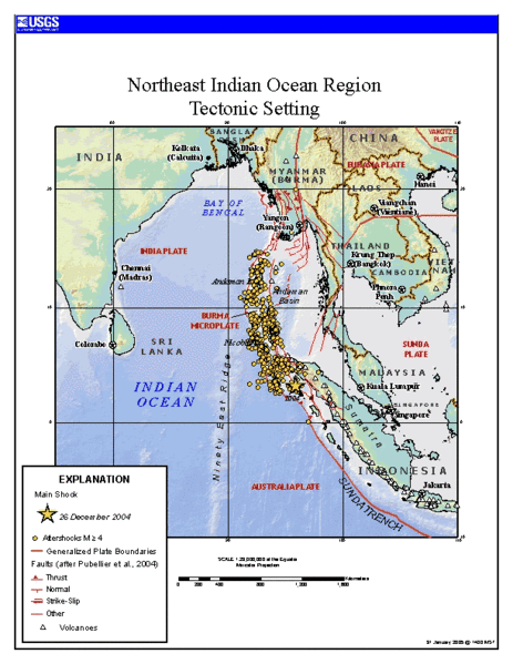
ไฟล, tectonics, sumatra, quake, ไฟล, ประว, ไฟล, หน, าท, ภาพน, การใช, ไฟล, วนกลางขนาดของต, วอย, างน, กเซล, ความละเอ, ยดอ, กเซล, กเซล, ภาพท, ความละเอ, ยดส, งกว, 8206, กเซล, ขนาดไฟล, โลไบต, ชน, ดไมม, image, นาท, ปภาพหร, อไฟล, เส, ยงน, นฉบ, บอย, คอมมอนส, รายละเอ, . ifl prawtiifl hnathimiphaphni karichiflswnklangkhnadkhxngtwxyangni 463 599 phikesl khwamlaexiydxun 185 240 phikesl 612 792 phikesl duphaphthimikhwamlaexiydsungkwa 8206 612 792 phikesl khnadifl 63 kiolibt chnidimm image gif 0 2 winathi rupphaphhruxiflesiyngni tnchbbxyuthi khxmmxns raylaexiyddanlang epnkhxkhwamthiaesdngphlcak ifltnchbbinkhxmmxns khxmmxnsepnewbistinokhrngkarsahrbekbrwbrwmsuxesri thi khunsamarthchwyid Source https earthquake usgs gov eqinthenews 2004 usslav Tectonic setting of Sumatra earthquake updated map first maps posted by USGS was showing unrealistic plate boundaries Public domain Public domain false false This image is in the public domain in the United States because it only contains materials that originally came from the United States Geological Survey an agency of the United States Department of the Interior For more information see the official USGS copyright policy Bahasa Indonesia nbsp catala nbsp cestina nbsp Deutsch nbsp eesti nbsp English nbsp espanol nbsp francais nbsp galego nbsp italiano nbsp Nederlands nbsp portugues nbsp polski nbsp sicilianu nbsp suomi nbsp Tiếng Việt nbsp Turkce nbsp blgarski nbsp makedonski nbsp russkij nbsp മലയ ള nbsp 한국어 nbsp 日本語 nbsp 中文 nbsp 中文 简体 nbsp 中文 繁體 nbsp العربية nbsp فارسی nbsp prawtiifl khlikwnthi ewlaephuxduiflthipraktinkhnann wnthi ewlarupyxkhnadphuichkhwamehn pccubn19 24 24 mkrakhm 2549612 792 63 kiolibt RobinL commonswiki Source http earthquake usgs gov eqinthenews 2004 usslav Tectonic setting of Sumatra earthquake updated map first maps posted by USGS was showing unrealistic plate boundaries PD USGov USGS hnathimiphaphni hnatxipni oyngmathiphaphni thaelxndamn aephnphma karichiflswnklang wikixuntxipniichiflni karichbn ar wikipedia org صفيحة بورما karichbn ca wikipedia org Arc de la Sonda karichbn el wikipedia org 8alassa Antaman karichbn en wikipedia org Andaman Sea Eurasian Plate Burma Plate Tenasserim Hills Yangtze Plate User Bettymnz4 Geology of Bangladesh Mae Chan Fault Sagaing Fault Red River Fault Template Indochina plates Three Pagodas Fault West Andaman Fault karichbn es wikipedia org Arco de Sonda karichbn fa wikipedia org کمان آتشفشانی سوندا karichbn fr wikipedia org Mer d Andaman karichbn hi wikipedia org स न द च प karichbn id wikipedia org Perbukitan Tenasserim karichbn ja wikipedia org スマトラ島沖地震 2004年 karichbn ko wikipedia org 버마판 karichbn my wikipedia org တနင သ ရ တ င တန karichbn pt wikipedia org Montes Tenasserim karichbn ru wikipedia org Andamanskoe more karichbn sl wikipedia org Andamansko morje karichbn sr wikipedia org Andamansko more karichbn tr wikipedia org Sunda Yayi karichbn uk wikipedia org Andamanske more karichbn zh wikipedia org 緬甸板塊 巽他島弧 ekhathungcak https th wikipedia org wiki ifl Tectonics Sumatra quake gif, wikipedia, วิกิ หนังสือ, หนังสือ, ห้องสมุด,