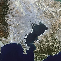
English: This false-color Landsat 7 image shows (a large part of) the greater Tokyo metropolitan area, situated on the eastern shore of the Japanese island of Honshu. The large Tokyo Bay dominates the center of this scene, and if you look closely you can see boats and their wakes on the water. The greater Tokyo area fans out in a crescent shape around the western, northern, and eastern shores of Tokyo Bay. Greater Tokyo is bordered to the west by rugged mountains and to the east by the vast expanse of the Pacific Ocean. The greater metropolis area is comprised of Tokyo prefecture, situated on the northwestern shore of Tokyo Bay, and the three neighboring prefectures of Kanagawa to the south, Saitama to the north, and Chiba to the east and southeast across Tokyo Bay. Over the last 400 years, Japan’s National Capital Region has evolved into a large, self-governing unit consisting of 26 cities, 5 towns, and 8 villages. The region is home to some 38 million people in 2018 (more than a quarter of Japan’s whole population) in a metropolitan area spanning 14,034 square km.
ไฟล, tokyo, ไฟล, ประว, ไฟล, หน, าท, ภาพน, การใช, ไฟล, วนกลาง, อม, ลเก, ยวก, บภาพขนาดของต, วอย, างน, กเซล, ความละเอ, ยดอ, กเซล, กเซล, กเซล, ภาพท, ความละเอ, ยดส, งกว, 8206, กเซล, ขนาดไฟล, โลไบต, ชน, ดไมม, image, jpeg, ปภาพหร, อไฟล, เส, ยงน, นฉบ, บอย, คอมมอนส, รา. ifl prawtiifl hnathimiphaphni karichiflswnklang khxmulekiywkbphaphkhnadkhxngtwxyangni 600 600 phikesl khwamlaexiydxun 240 240 phikesl 480 480 phikesl 1 000 1 000 phikesl duphaphthimikhwamlaexiydsungkwa 8206 1 000 1 000 phikesl khnadifl 511 kiolibt chnidimm image jpeg rupphaphhruxiflesiyngni tnchbbxyuthi khxmmxns raylaexiyddanlang epnkhxkhwamthiaesdngphlcak ifltnchbbinkhxmmxns khxmmxnsepnewbistinokhrngkarsahrbekbrwbrwmsuxesri thi khunsamarthchwyid khwamyx khaxthibayTokyo L7 lrg jpg English This false color Landsat 7 image shows a large part of the greater Tokyo metropolitan area situated on the eastern shore of the Japanese island of Honshu The large Tokyo Bay dominates the center of this scene and if you look closely you can see boats and their wakes on the water The greater Tokyo area fans out in a crescent shape around the western northern and eastern shores of Tokyo Bay Greater Tokyo is bordered to the west by rugged mountains and to the east by the vast expanse of the Pacific Ocean The greater metropolis area is comprised of Tokyo prefecture situated on the northwestern shore of Tokyo Bay and the three neighboring prefectures of Kanagawa to the south Saitama to the north and Chiba to the east and southeast across Tokyo Bay Over the last 400 years Japan s National Capital Region has evolved into a large self governing unit consisting of 26 cities 5 towns and 8 villages The region is home to some 38 million people in 2018 more than a quarter of Japan s whole population in a metropolitan area spanning 14 034 square km 日本語 東京湾の衛星画像 2002年 人工衛星 NASA Earth Observatory による wnthi 11 tulakhm ph s 2545 aehlngthima Earth Observatory phusrangsrrkh Image courtesy Ron Beck USGS Eros Data Center Satellite Systems Branch karxnuyatichsiththi Public domain Public domain false false phaphniepnsatharnsmbti enuxngcakepnphaphthisrangkhunodyxngkhkarbriharkarbinaelaxwkasaehngchati NASA sungtamnoybaydanlikhsiththikhxngnasarabuiwwa phaphaelasuxtang khxngnasaimidrbkarkhumkhrxngodylikhsiththiykewncarabuiwwamilikhsiththi duephimthi hnanoybaydanlikhsiththikhxngnasa hrux noybaykarichphaphkhxng JPL khaetuxn karich olokkhxngnasa ekhruxnghmayaelaekhruxngpradbkhxngnasa thukcakddwykdhmayshrthxemrikainlksna 14 khxngkhxbngkhbthangrachkarshrthxemrika swnthi 1221 ewbistkhxngnasaekbrwbrwmphaphthimacakxngkhkarxwkasosewiyt xngkhkarxwkasaehngchatirsesiy aelaxngkhkarxwkasthimiichxngkhkarxwkaskhxngshrthxemrika epncanwnmak phaphehlaniimcaepntxngepnsatharnsmbtiesmxip phaphhruxsuxthimacak klxngothrthrrsnxwkashbebil xacmilikhsiththi hakphaphhruxsuxnnimidrabuchdecnwamacak sthabnwithyasastrklxngothrthrrsnxwkas 1 phaphhruxsuxthnghmdthimacakekhruxngmuxkhxng okhrngkarsuksadwngxathityaelalmsuriya milikhsiththi karnaphaphhruxsuxcakokhrngkaripichnxkehnuxcakkarichephuxkarkhahruxephuxkarsuksa txngidrbxnuyatkxn 2 phaphthithukkhdeluxkihepn phaphdarasastrpracawn APOD bnewbistkhxng APOD xacmilikhsiththi 3 khabrryayodyyxithyephimkhabrryaythrrthdediywephuxkhyaykhwamwaiflnimixairxngkvsSatellite photo of Tokyo Bay 2002 yipun東京湾の衛星写真 2002年 ixethmthiaesdngxyuiniflniprakxbdwywnthisrang wnkxtng11 tulakhm 2002 prawtiifl khlikwnthi ewlaephuxduiflthipraktinkhnann wnthi ewlarupyxkhnadphuichkhwamehn pccubn21 25 18 phvscikayn 25511 000 1 000 511 kiolibt Jyusin Information Description en 1 Tokyo ja 1 東京 Source http earthobservatory nasa gov IOTD view php id 2854 Earth Observatory Author NASA Date Permission other versions lt ImageUpload full gt hnathimiphaphni immihnaidoyngmathiphaphnikarichiflswnklang wikixuntxipniichiflni karichbn az wikipedia org Aqlomerasiya regionu karichbn de wikipedia org Bucht von Tokio karichbn es wikipedia org Aglomeracion urbana Bahia de Tokio karichbn fr wikipedia org Baie de Tokyo karichbn hu wikipedia org Tokioi obol karichbn it wikipedia org Baia di Tokyo karichbn ja wikipedia org 東京湾 南関東直下地震 karichbn pt wikipedia org Metropole karichbn simple wikipedia org Tokyo Bay karichbn tr wikipedia org Metropoliten alan karichbn vi wikipedia org Vịnh Tokyo karichbn zh wikipedia org 關東地方khxmulekiywkbphaph phaphnimikhxmulephimetim sungswnihymacakklxngdicitxlhruxsaeknenxrthisamarthekbkhxmuldngklawiwrwmkbphaphid thaphaphnithukprbprungaekikhhruxepliynaeplngcakedim khxmulbangxyangcayngkhngimepliynaeplngehmuxnphaphthithukprbprungaekikhnn 95 error0 ekhathungcak https th wikipedia org wiki ifl Tokyo L7 lrg jpg, wikipedia, วิกิ หนังสือ, หนังสือ, ห้องสมุด,