คำอธิบายTutankhamen map Valle Re Nilo space STS026-041-058.jpg
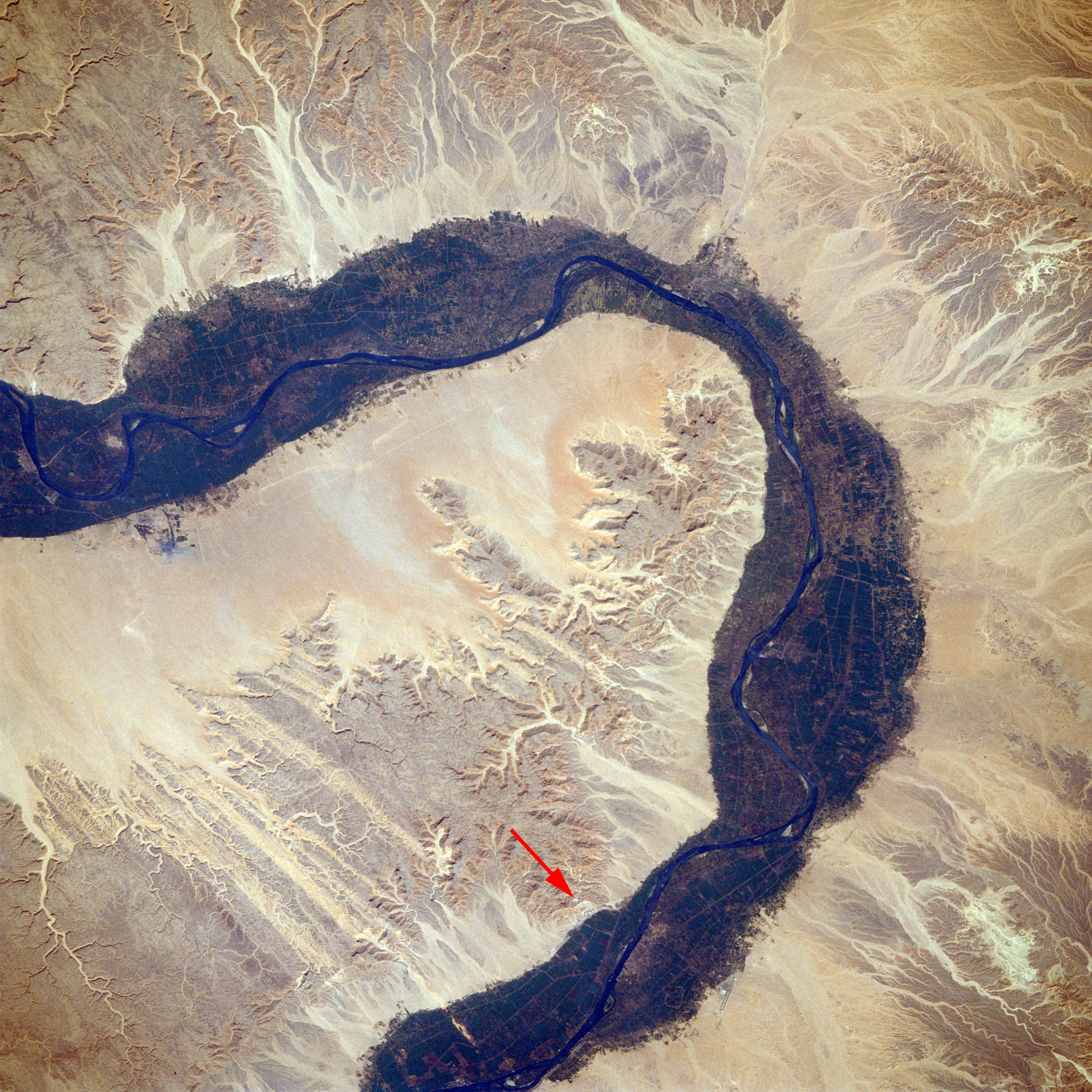
English: Valley of the Kings, Southern Egypt October 1988 Arid landforms comprise much of this nearly vertical view of a portion of the Nile River. These desert landforms include eroded valleys and wadis (watercourses). The fertile and highly productive green Nile River Valley stands out in marked contrast to the tan desert landscape on either side. This part of the Nile Valley varies in width from 4 to 9 miles (6 to 14 kilometers). Near the southern edge of this photograph, the city of Luxor can be ascertained along the eastern bank of the Nile. The narrow, linear runways of the airport are visible on the edge of the desert east of the city. This particular bend in the Nile River is the home of many historical points of interest-Valley of the Kings, Valley of the Queens, Temple of Luxor, Tomb of Tutankhamen, and Necropolis of Thebes.
Italiano: Valle dei Re, Egitto Meridionale, Ottobre 1988
La maggior parte di questa fotografia, ripresa circa sulla verticale di una parte del fiume Nilo, comprende territori desertici. Questo territorio desertico include valli erose e torrenti stagionali. La verde Valle sulla riva del Nilo, fertile e molto produttiva si estende in un marcato contrasto con il panorama desertico da entrambe le rive. Questa parte della Valle del Nilo ha una larghezza che varia da 6 a 14 chilometri (4 a 6 miglia). Si può riconoscere la città di Luxor, vicino al bordo meridionale di questa fotografia, lungo la riva orientale del Nilo. A Est della città, sul bordo del deserto, sono visibili le strette e diritte piste di atterraggio dell'aeroporto. Questa particolare fascia della riva del Nilo è sede di molti punti di interesse storico come la Valle dei Re, la Valle della Regine, il Tempio di Luxor, la tomba di Tutankhamen e l'antico cimitero di Tebe.
STS026-041-058 è una sigla che indica in modo univoco la fonte di questa foto, STS026 è la sigla della missione shuttle Discovery che ha ripreso la foto n° 041-058.
วันที่
แหล่งที่มา
EARTH FROM SPACE Valley of the King STS026-041-058
ผู้สร้างสรรค์
NASA/Crew of STS-26
เวอร์ชันอื่น
Valley of the Kings from space STS026-041-058.tif – NASA's original
This image or video was catalogued by Johnson Space Center of the United States National Aeronautics and Space Administration (NASA) under Photo ID: STS026-041-058.
This tag does not indicate the copyright status of the attached work. A normal copyright tag is still required.See Commons:Licensing.العربية ∙ беларуская (тарашкевіца) ∙ български ∙ català ∙ čeština ∙ dansk ∙ Deutsch ∙ English ∙ español ∙ فارسی ∙ français ∙ galego ∙ magyar ∙ հայերեն ∙ Bahasa Indonesia ∙ italiano ∙ 日本語 ∙ македонски ∙ മലയാളം ∙ Nederlands ∙ polski ∙ português ∙ русский ∙ sicilianu ∙ Türkçe ∙ українська ∙ 简体中文 ∙ 繁體中文 ∙ +/−
ไฟล, tutankhamen, valle, nilo, space, sts026, ไฟล, ประว, ไฟล, หน, าท, ภาพน, การใช, ไฟล, วนกลาง, อม, ลเก, ยวก, บภาพขนาดของต, วอย, างน, กเซล, ความละเอ, ยดอ, กเซล, กเซล, กเซล, กเซล, กเซล, กเซล, ภาพท, ความละเอ, ยดส, งกว, 8206, กเซล, ขนาดไฟล, เมกะไบต, ชน, ดไมม, ima. ifl prawtiifl hnathimiphaphni karichiflswnklang khxmulekiywkbphaphkhnadkhxngtwxyangni 600 600 phikesl khwamlaexiydxun 240 240 phikesl 480 480 phikesl 768 768 phikesl 1 024 1 024 phikesl 2 048 2 048 phikesl 5 104 5 104 phikesl duphaphthimikhwamlaexiydsungkwa 8206 5 104 5 104 phikesl khnadifl 18 06 emkaibt chnidimm image jpeg rupphaphhruxiflesiyngni tnchbbxyuthi khxmmxns raylaexiyddanlang epnkhxkhwamthiaesdngphlcak ifltnchbbinkhxmmxns khxmmxnsepnewbistinokhrngkarsahrbekbrwbrwmsuxesri thi khunsamarthchwyid khwamyx khaxthibayTutankhamen map Valle Re Nilo space STS026 041 058 jpg English Valley of the Kings Southern Egypt October 1988 Arid landforms comprise much of this nearly vertical view of a portion of the Nile River These desert landforms include eroded valleys and wadis watercourses The fertile and highly productive green Nile River Valley stands out in marked contrast to the tan desert landscape on either side This part of the Nile Valley varies in width from 4 to 9 miles 6 to 14 kilometers Near the southern edge of this photograph the city of Luxor can be ascertained along the eastern bank of the Nile The narrow linear runways of the airport are visible on the edge of the desert east of the city This particular bend in the Nile River is the home of many historical points of interest Valley of the Kings Valley of the Queens Temple of Luxor Tomb of Tutankhamen and Necropolis of Thebes Italiano Valle dei Re Egitto Meridionale Ottobre 1988 La maggior parte di questa fotografia ripresa circa sulla verticale di una parte del fiume Nilo comprende territori desertici Questo territorio desertico include valli erose e torrenti stagionali La verde Valle sulla riva del Nilo fertile e molto produttiva si estende in un marcato contrasto con il panorama desertico da entrambe le rive Questa parte della Valle del Nilo ha una larghezza che varia da 6 a 14 chilometri 4 a 6 miglia Si puo riconoscere la citta di Luxor vicino al bordo meridionale di questa fotografia lungo la riva orientale del Nilo A Est della citta sul bordo del deserto sono visibili le strette e diritte piste di atterraggio dell aeroporto Questa particolare fascia della riva del Nilo e sede di molti punti di interesse storico come la Valle dei Re la Valle della Regine il Tempio di Luxor la tomba di Tutankhamen e l antico cimitero di Tebe STS026 041 058 e una sigla che indica in modo univoco la fonte di questa foto STS026 e la sigla della missione shuttle Discovery che ha ripreso la foto n 041 058 wnthi 1 tulakhm ph s 2531aehlngthima EARTH FROM SPACE Valley of the King STS026 041 058phusrangsrrkh NASA Crew of STS 26ewxrchnxun Valley of the Kings from space STS026 041 058 tif NASA s original This image or video was catalogued by Johnson Space Center of the United States National Aeronautics and Space Administration NASA under Photo ID STS026 041 058 This tag does not indicate the copyright status of the attached work A normal copyright tag is still required See Commons Licensing العربية belaruskaya tarashkevica blgarski catala cestina dansk Deutsch English espanol فارسی francais galego magyar հայերեն Bahasa Indonesia italiano 日本語 makedonski മലയ ള Nederlands polski portugues russkij sicilianu Turkce ukrayinska 简体中文 繁體中文 karxnuyatichsiththi Public domain Public domain false falseThis file is in the public domain in the United States because it was created by the Image Science amp Analysis Laboratory of the NASA Johnson Space Center NASA copyright policy states that NASA material is not protected by copyright unless noted NASA media use guidelines or Conditions of Use of Astronaut Photographs Photo source STS026 041 058 العربي ة Deutsch English espanol francais italiano kurdi makedonski മലയ ള portugues sicilianu khabrryayodyyxithyephimkhabrryaythrrthdediywephuxkhyaykhwamwaiflnimixairixethmthiaesdngxyuiniflniprakxbdwysthanalikhsiththisatharnsmbtidetermination method xngkvs work of the federal government of the United States xngkvswnthisrang wnkxtng1 tulakhm 1988catalog code xngkvsSTS026 041 058aekhttalxk Media catalogue of the Johnson Space Center xngkvsMIME type xngkvsimage jpeg prawtiifl khlikwnthi ewlaephuxduiflthipraktinkhnann wnthi ewlarupyxkhnadphuichkhwamehn pccubn06 53 12 phvscikayn 25575 104 5 104 18 06 emkaibt Ras67high resolution 22 40 4 minakhm 2550640 640 193 kiolibt NocladorValley of the Kings location corrected 16 37 19 singhakhm 2548640 640 77 kiolibt Roger469 PD NASA hnathimiphaphni hnatxipni oyngmathiphaphni hubekhakstriy karichiflswnklang wikixuntxipniichiflni karichbn af wikipedia org Vallei van die Konings karichbn ar wikipedia org محافظة الأقصر ويكيبيديا مقالة الصفحة الرئيسية المختارة 42 بوابة مصر مقالة مختارة بوابة مصر مقالة مختارة 32 karichbn bg wikipedia org Dolina na carete karichbn bn wikipedia org র জ দ র উপত যক karichbn el wikipedia org Koilada twn Basilewn karichbn en wikipedia org Portal Ancient Egypt Selected article Portal Ancient Egypt Selected article 4 User Chickstarr404 Gather lists 8448 Letters from Egypt by Lucy Duff Gordon karichbn ha wikipedia org Valley of the Kings karichbn hr wikipedia org Dolina kraljeva karichbn hu wikipedia org Kiralyok volgye Portalvita Vilagorokseg HetSzocikk Portal Vilagorokseg HetSzocikk 16 Wikipedia Szocikkek a kezdolapon 2017 I Sablon Kezdolap kiemelt cikkei 2017 21 1 karichbn hy wikipedia org Արքաների հովիտ Ռամզես X karichbn it wikipedia org Valle dei Re karichbn la wikipedia org Valles Regum karichbn lv wikipedia org Valdnieku ieleja karichbn mk wikipedia org Dolina na kralevite karichbn ml wikipedia org ര ജ ക കന മ ര ട ത ഴ വര karichbn ms wikipedia org Lembah Raja raja karichbn nn wikipedia org Kongedalen karichbn no wikipedia org Kongenes dal Brukerdiskusjon Cnyborg 2005 2 karichbn pt wikipedia org Vale dos Reis Portal Egito Banco de destaques Portal Egito Banco de destaques 3 karichbn ro wikipedia org Valea Regilor karichbn ru wikipedia org Dolina Carej karichbn sco wikipedia org Valley o the Keengs karichbn sh wikipedia org Dolina kraljeva karichbn simple wikipedia org Valley of the Kings karichbn so wikipedia org Dooxada Boqortooyada karichbn sw wikipedia org Bonde la Wafalme karichbn ta wikipedia org மன னர கள ன சமவ ள karichbn tl wikipedia org Lambak ng mga Hari karichbn tr wikipedia org Krallar Vadisi karichbn uk wikipedia org Dolina Cariv karichbn uz wikipedia org Shohlar Vodiysi karichbn vi wikipedia org Thung lũng cac vị Vuakhxmulekiywkbphaph phaphnimikhxmulephimetim sungswnihymacakklxngdicitxlhruxsaeknenxrthisamarthekbkhxmuldngklawiwrwmkbphaphid thaphaphnithukprbprungaekikhhruxepliynaeplngcakedim khxmulbangxyangcayngkhngimepliynaeplngehmuxnphaphthithukprbprungaekikhnnchuxphaphValley of the Kings Southern Egypt October 1988phuphlitklxngSTS 26runkhxngklxngValley of the KingsphuthaySTS 26 crew memberphuthrnglikhsiththiNASAewlathibnthukphaph08 33 1 tulakhm 2531khwamkwang5 700 phikeslkhwamsung5 900 phikeslbittxkhxmophennt16 16 16rupaebbkarbibxdimidbibxdphikeslkhxmophsichnRGBkarcdwangphaphpkticanwnkhxmophennt3khwamlaexiydaenwnxn300 dpikhwamlaexiydaenwtng300 dpikarcderiyngkhxmulrupaebbchngkisxftaewrthiichAdobe Photoshopaekikhphaphlasud22 32 11 phvscikayn 2557ewlathiaeplngepndicithl16 13 2 krkdakhm 2556khwamehnphuichSTS026 041 058sepssisRGB ekhathungcak https th wikipedia org wiki ifl Tutankhamen map Valle Re Nilo space STS026 041 058 jpg, wikipedia, วิกิ หนังสือ, หนังสือ, ห้องสมุด,