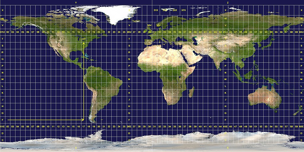
English: The longitude and latitude zones in the Universal Transverse Mercator system.
Longitude zones are six degrees wide. They are numbered from 01 at 180° west, increasing towards the east until 60 at 180° east.
Latitude zones are 8° high. They are lettered from C to X, omitting the letters "I" and "O", beginning at 80° south. The letters A, B, Y and Z are used in the polar regions by the Universal Polar Stereographic grid system.
A grid reference is read "right, up", as indicated by the arrows. A reference is always written with the longitude zone first. In this example, "17T".
Exceptions to the system are apparent. The west coast of Norway is given a wider zone 32V, taking some space from the zone 31V that covers open water. The zones around Svalbard are also widened, effectively deleting some longitude zones at this latitude. Finally, the entire latitude zone "X" is extended an extra 4°, topping off at 84° north.
การอนุญาตใช้สิทธิ
Public domainPublic domainfalsefalse
https://creativecommons.org/publicdomain/mark/1.0/PDMCreative Commons Public Domain Mark 1.0falsefalse
This image was constructed from a public domain Visible Earth product of the Earth Observatory office of the United States government space agency NASA. It is based on a cylindrical equi-distant projection, and was marked up by custom software created specifically for the Wikipedia.
The longitude and latitude zones in the Universal Transverse Mercator system. Longitude zones are six degrees wide. They are numbered from 01 at 180° west, increasing towards the east until 60 at 180° east. Latitude zones are 8° high. They are le
ไฟล, zones, ไฟล, ประว, ไฟล, หน, าท, ภาพน, การใช, ไฟล, วนกลาง, อม, ลเก, ยวก, บภาพขนาดของต, วอย, างน, กเซล, ความละเอ, ยดอ, กเซล, กเซล, กเซล, กเซล, กเซล, ภาพท, ความละเอ, ยดส, งกว, 8206, กเซล, ขนาดไฟล, โลไบต, ชน, ดไมม, image, jpeg, ปภาพหร, อไฟล, เส, ยงน, นฉบ, บอย,. ifl prawtiifl hnathimiphaphni karichiflswnklang khxmulekiywkbphaphkhnadkhxngtwxyangni 800 400 phikesl khwamlaexiydxun 320 160 phikesl 640 320 phikesl 1 024 512 phikesl 1 280 640 phikesl 2 048 1 024 phikesl duphaphthimikhwamlaexiydsungkwa 8206 2 048 1 024 phikesl khnadifl 821 kiolibt chnidimm image jpeg rupphaphhruxiflesiyngni tnchbbxyuthi khxmmxns raylaexiyddanlang epnkhxkhwamthiaesdngphlcak ifltnchbbinkhxmmxns khxmmxnsepnewbistinokhrngkarsahrbekbrwbrwmsuxesri thi khunsamarthchwyid khwamyx English The longitude and latitude zones in the Universal Transverse Mercator system Longitude zones are six degrees wide They are numbered from 01 at 180 west increasing towards the east until 60 at 180 east Latitude zones are 8 high They are lettered from C to X omitting the letters I and O beginning at 80 south The letters A B Y and Z are used in the polar regions by the Universal Polar Stereographic grid system A grid reference is read right up as indicated by the arrows A reference is always written with the longitude zone first In this example 17T Exceptions to the system are apparent The west coast of Norway is given a wider zone 32V taking some space from the zone 31V that covers open water The zones around Svalbard are also widened effectively deleting some longitude zones at this latitude Finally the entire latitude zone X is extended an extra 4 topping off at 84 north karxnuyatichsiththi Public domain Public domain false falsenganniepn satharnsmbti inpraethsshrthxemrika enuxngcakepnngankhxngrthbalklangshrthxemrika thngni tamkhwamkhxngmatra 105 hmwd 1 lksna 17 aehngpramwlkdhmayshrthxemrika duephimthi likhsiththi hmayehtu khxkhwamkhangtnichbngkhbaekngankhxngrthbalklangshrthxemrikaethann ngankhxngrthid inshrthxemrika dinaedn ekhruxckrphph ethsmnthl ethsbal hruxxngkhkrpkkhrxngswnthxngthinxunid imthuxepnnganthiepnsatharnsmbtitampramwlkdhmayni nxkcakni aemaebbniimichkbtraiprsniyakraebbid thikrmiprsniyaehngshrthxemrika naxxkichtngaet kh s 1978 ph s 2521 epntnma sungmilikhsiththiaelaimepnsatharnsmbti duraylaexiydthi raebiybaehngsanknganlikhsiththi bthyxthi 2 khx 206 02 b iflniidthukrabuwaimmikhxcakdphayitkdhmaylikhsiththi rwmthungsiththithiekiywkhxngaelathiiklekhiyngknhttps creativecommons org publicdomain mark 1 0 PDM Creative Commons Public Domain Mark 1 0 false falseThis image was constructed from a public domain Visible Earth product of the Earth Observatory office of the United States government space agency NASA It is based on a cylindrical equi distant projection and was marked up by custom software created specifically for the Wikipedia xnuyatihkhdlxk aeckcayaela hruxddaeprexksarniphayitenguxnikhkhxngsyyaxnuyatexksaresrikhxngknu run 1 2 hruxrunid nbcaknithixxkodymulnithisxftaewresri odyimmiswnidhamaekikh immikhxkhwampkhnaaelapkhlng saenakhxngsyyaxnuyatrwmxyuinswnchux syyaxnuyatexksaresrikhxngknu thngni epniptamkhxptiesthkhwamrbphidchxbhttp www gnu org copyleft fdl html GFDL GNU Free Documentation License true trueiflnixyuphayitsyyaxnuyat khriexthifkhxmmxns aebbaesdngthima xnuyataebbediywkn 3 0 tnchbb thngni epniptamkhxptiesthkhwamrbphidchxbkhunsamarth thicaaebngpn thicathasaena aeckcay aelasngngandngklawtxip thicaeriyberiyngihm thicaddaeplngngandngklaw phayitenguxnikhtxipni aesdngthima khuntxngihekiyrtiecakhxngnganxyangehmaasm odyephimlingkipyngsyyaxnuyat aelarabuhakmikarepliynaeplng khunxacthaechnniidinrupaebbidkidtamkhwr aettxngimichinlksnathiaenawaphuihxnuyatsnbsnunkhunhruxkarichngankhxngkhun xnuyataebbediywkn hakkhunddaeplng epliynrup hruxtxetimnganni khuntxngichsyyaxnuyataebbediywknhruxaebbthiehmuxnkbsyyaxnuyatthiichkbnganniethannpayaesdngsthanalikhsiththinithukephimephuxihepniptamkarepliynaeplngsyyaxnuyatkhxngmulnithiwikimiediy cak GFDL ipyng GFDL khwbkhukb CC BY SA 3 0 http creativecommons org licenses by sa 3 0 CC BY SA 3 0 Creative Commons Attribution Share Alike 3 0 true truekhabrryayodyyxithyephimkhabrryaythrrthdediywephuxkhyaykhwamwaiflnimixairixethmthiaesdngxyuiniflniprakxbdwysthanalikhsiththimilikhsiththisyyaxnuyatGNU Free Documentation License version 1 2 or later xngkvsCreative Commons Attribution ShareAlike 3 0 Unported xngkvsMIME type xngkvsimage jpeg prawtiifl khlikwnthi ewlaephuxduiflthipraktinkhnann wnthi ewlarupyxkhnadphuichkhwamehn pccubn18 08 26 mkrakhm 25502 048 1 024 821 kiolibt Jan Krymmel commonswikiThe longitude and latitude zones in the Universal Transverse Mercator system Longitude zones are six degrees wide They are numbered from 01 at 180 west increasing towards the east until 60 at 180 east Latitude zones are 8 high They are le hnathimiphaphni hnatxipni oyngmathiphaphni rabbphikdkridaebbyuthiexm karichiflswnklang wikixuntxipniichiflni karichbn ar wikipedia org توجه نحو الشرق والشمال نظام إسقاط ميركاتور المستعرض العالمي karichbn ast wikipedia org Sistema de Coordenaes Universal Tresversal Mercator karichbn ca wikipedia org Projeccio Universal Transversa de Mercator karichbn cs wikipedia org UTM karichbn da wikipedia org Universal Transverse Mercator karichbn de wikipedia org UTM Koordinatensystem karichbn en wikipedia org User Mdf karichbn es wikipedia org Sistema de coordenadas universal transversal de Mercator karichbn et wikipedia org Mercatori universaalne poikprojektsioon Silindriline projektsioon karichbn eu wikipedia org Txikipedia Longitude karichbn fa wikipedia org سامانه مختصات جهانی مرکاتور معکوس karichbn he wikipedia org רשת UTM karichbn hu wikipedia org UTM karichbn ilo wikipedia org Sistema ti nagsasabtan ti UTM karichbn ko wikipedia org UTM 좌표계 karichbn mk wikipedia org Topografska karta karichbn nl wikipedia org Oostwaarde en noordwaarde karichbn no wikipedia org UTM koordinater Military grid reference system karichbn pl wikipedia org Uklad UTM Godlo mapy karichbn pt wikipedia org Universal Transversa de Mercator karichbn sv wikipedia org Military Grid Reference System karichbn ta wikipedia org ய ன வ ர சல ட ர ன ஸ வ ர ஸ ம ர க ட டர ப ர ஜ க சன UTM karichbn uk wikipedia org Sistema koordinat UTM karichbn zh wikipedia org 通用横轴墨卡托投影khxmulekiywkbphaph phaphnimikhxmulephimetim sungswnihymacakklxngdicitxlhruxsaeknenxrthisamarthekbkhxmuldngklawiwrwmkbphaphid thaphaphnithukprbprungaekikhhruxepliynaeplngcakedim khxmulbangxyangcayngkhngimepliynaeplngehmuxnphaphthithukprbprungaekikhnnkarcdwangphaphpktikhwamlaexiydaenwnxn72 dpikhwamlaexiydaenwtng72 dpisxftaewrthiichAdobe Photoshop Elements 2 0aekikhphaphlasud19 04 31 tulakhm 2548sepssiimidprbethiyb ekhathungcak https th wikipedia org wiki ifl Utm zones jpg, wikipedia, วิกิ หนังสือ, หนังสือ, ห้องสมุด,