ภาพแผนที่ทางประวัติศาสตร์นี้ ควรจะถูกสร้างใหม่เป็นกราฟิกส์เวกเตอร์ ซึ่งมีข้อดีอีกหลายประการ ดูเพิ่มเติมที่คอมมอนส์:สื่อต้องการเก็บกวาดสำหรับสารสนเทศเพิ่มเติม หากภาพนี้มีในรูปแบบกราฟิกส์เวกเตอร์อยู่แล้ว กรุณาอัปโหลดและแทนที่แม่แบบนี้ด้วย {{vector version available|ชื่อภาพใหม่}} แนะนำเป็นอย่างยิ่งให้ตั้งชื่อไฟล์เวกเตอร์ใหม่นั้นในรูปแบบ "VietnamChampa1.svg" แล้วใส่แม่แบบ Vector version available (หรือ Vva) ซึ่งไม่ต้องใช้พารามิเตอร์ ชื่อภาพใหม่
คำอธิบายVietnamChampa1.gif
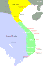
English: Southeast Asia circa 1100 C.E. showing the approximate areas of control for the Dai-Viet (Vietnam), Champa, and Khmer Empires. Note: Control of the regions away from the coast of Vietnam was more nominal than real except along the Red River.
Dai Viet Champa Khmer
แหล่งที่มา
This map has been uploaded by Electionworld from en.wikipedia.org to enable the Wikimedia Atlas of the World . Original uploader to en.wikipedia.org was Cglassey, known as Cglassey at en.wikipedia.org. Electionworld is not the creator of this map. Licensing information is below.
ผู้สร้างสรรค์
Created by CGlassey, based on maps found in DK Atlas of World History and the Times Atlas of World History.
{{ew|en|Cglassey}} South East Asia circa 1100 C.E. showing the approximate areas of control for the Dai-Viet (Vietnam), Champa, and Khmer Empires. Note: Control of the regions away from the coast of Vietnam was more nominal than real except along the Red
ไฟล, vietnamchampa1, ไฟล, ประว, ไฟล, หน, าท, ภาพน, การใช, ไฟล, วนกลางขนาดของต, วอย, างน, กเซล, ความละเอ, ยดอ, กเซล, กเซล, ภาพท, ความละเอ, ยดส, งกว, 8206, กเซล, ขนาดไฟล, โลไบต, ชน, ดไมม, image, ปภาพหร, อไฟล, เส, ยงน, นฉบ, บอย, คอมมอนส, รายละเอ, ยดด, านล, าง, เป. ifl prawtiifl hnathimiphaphni karichiflswnklangkhnadkhxngtwxyangni 361 600 phikesl khwamlaexiydxun 144 240 phikesl 425 706 phikesl duphaphthimikhwamlaexiydsungkwa 8206 425 706 phikesl khnadifl 27 kiolibt chnidimm image gif rupphaphhruxiflesiyngni tnchbbxyuthi khxmmxns raylaexiyddanlang epnkhxkhwamthiaesdngphlcak ifltnchbbinkhxmmxns khxmmxnsepnewbistinokhrngkarsahrbekbrwbrwmsuxesri thi khunsamarthchwyid phaphaephnthithangprawtisastrni khwrcathuksrangihmepnkrafiksewketxr sungmikhxdixikhlayprakar duephimetimthikhxmmxns suxtxngkarekbkwadsahrbsarsnethsephimetim hakphaphnimiinrupaebbkrafiksewketxrxyuaelw krunaxpohldaelaaethnthiaemaebbnidwy vector version available i chuxphaphihm i aenanaepnxyangyingihtngchuxiflewketxrihmnninrupaebb VietnamChampa1 svg aelwisaemaebb Vector version available hrux Vva sungimtxngichpharamietxr chuxphaphihmkhaxthibayVietnamChampa1 gif English Southeast Asia circa 1100 C E showing the approximate areas of control for the Dai Viet Vietnam Champa and Khmer Empires Note Control of the regions away from the coast of Vietnam was more nominal than real except along the Red River Dai Viet Champa Khmeraehlngthima This map has been uploaded by Electionworld from en wikipedia org to enable the Wikimedia Atlas of the World Original uploader to en wikipedia org was Cglassey known as Cglassey at en wikipedia org Electionworld is not the creator of this map Licensing information is below phusrangsrrkh Created by CGlassey based on maps found in DK Atlas of World History and the Times Atlas of World History karxnuyat karichiflniihm khapheca inthanaphuthuxlikhsiththikhxngphaphhruxsuxni xnuyatihichphaphhruxsuxniphayitenguxnikhtxipni xnuyatihkhdlxk aeckcayaela hruxddaeprexksarniphayitenguxnikhkhxngsyyaxnuyatexksaresrikhxngknu run 1 2 hruxrunid nbcaknithixxkodymulnithisxftaewresri odyimmiswnidhamaekikh immikhxkhwampkhnaaelapkhlng saenakhxngsyyaxnuyatrwmxyuinswnchux syyaxnuyatexksaresrikhxngknuhttp www gnu org copyleft fdl html GFDL GNU Free Documentation License true trueiflnixyuphayitsyyaxnuyat khriexthifkhxmmxns aebbaesdngthima xnuyataebbediywkn 3 0 tnchbbkhunsamarth thicaaebngpn thicathasaena aeckcay aelasngngandngklawtxip thicaeriyberiyngihm thicaddaeplngngandngklaw phayitenguxnikhtxipni aesdngthima khuntxngihekiyrtiecakhxngnganxyangehmaasm odyephimlingkipyngsyyaxnuyat aelarabuhakmikarepliynaeplng khunxacthaechnniidinrupaebbidkidtamkhwr aettxngimichinlksnathiaenawaphuihxnuyatsnbsnunkhunhruxkarichngankhxngkhun xnuyataebbediywkn hakkhunddaeplng epliynrup hruxtxetimnganni khuntxngichsyyaxnuyataebbediywknhruxaebbthiehmuxnkbsyyaxnuyatthiichkbnganniethannpayaesdngsthanalikhsiththinithukephimephuxihepniptamkarepliynaeplngsyyaxnuyatkhxngmulnithiwikimiediy cak GFDL ipyng GFDL khwbkhukb CC BY SA 3 0 http creativecommons org licenses by sa 3 0 CC BY SA 3 0 Creative Commons Attribution Share Alike 3 0 true trueiflnixyuphayitsyyaxnuyatkhriexthifkhxmmxns runaesdngthima 2 5 thwipkhunsamarth thicaaebngpn thicathasaena aeckcay aelasngngandngklawtxip thicaeriyberiyngihm thicaddaeplngngandngklaw phayitenguxnikhtxipni aesdngthima khuntxngihekiyrtiecakhxngnganxyangehmaasm odyephimlingkipyngsyyaxnuyat aelarabuhakmikarepliynaeplng khunxacthaechnniidinrupaebbidkidtamkhwr aettxngimichinlksnathiaenawaphuihxnuyatsnbsnunkhunhruxkarichngankhxngkhunhttps creativecommons org licenses by 2 5 CC BY 2 5 Creative Commons Attribution 2 5 true truekhunsamartheluxksyyaxnuyatdngklawtamtxngkarewxrchnxun frngess rsesiykhabrryayodyyxithyephimkhabrryaythrrthdediywephuxkhyaykhwamwaiflnimixairixethmthiaesdngxyuiniflniprakxbdwysthanalikhsiththimilikhsiththisyyaxnuyatCreative Commons Attribution 2 5 Generic xngkvsGNU Free Documentation License version 1 2 or later xngkvsCreative Commons Attribution ShareAlike 3 0 Unported xngkvsMIME type xngkvsimage gif prawtiifl khlikwnthi ewlaephuxduiflthipraktinkhnann wnthi ewlarupyxkhnadphuichkhwamehn pccubn11 58 5 krkdakhm 2563425 706 27 kiolibt SgnpkdUpdates on sites 04 38 21 mkrakhm 2552425 666 8 kiolibt Gryffindor Information Description Source Own work by uploader Date Author Gryffindor Permission other versions 04 15 21 mkrakhm 2552425 666 9 kiolibt Gryffindor Information Description Source Own work by uploader Date Author Gryffindor Permission other versions 04 31 8 thnwakhm 2549425 666 9 kiolibt Electionworld ew en Cglassey South East Asia circa 1100 C E showing the approximate areas of control for the Dai Viet Vietnam Champa and Khmer Empires Note Control of the regions away from the coast of Vietnam was more nominal than real except along the Red hnathimiphaphni hnatxipni oyngmathiphaphni campa karichiflswnklang wikixuntxipniichiflni karichbn ace wikipedia org Champa karichbn ar wikipedia org تشام karichbn azb wikipedia org چامپا چاملار karichbn bn wikipedia org ভ য তন ম র ইত হ স চ য ম জ ত karichbn cs wikipedia org Campa karichbn da wikipedia org Cambodja Champa karichbn en wikipedia org Chams Buddhism in Vietnam History of the Song dynasty Timeline of the Song dynasty Vietnamese irredentism karichbn eo wikipedia org Ĉamoj etno Ĉampa karichbn fa wikipedia org چامپا مردم چام karichbn fi wikipedia org Vietnamin historia Champa karichbn fi wikibooks org Wikijunior Muinaiset kulttuurit Champa karichbn fr wikipedia org Wikipedia Atelier graphique Cartes Archives juin 2013 Bouddhisme au Viet Nam karichbn he wikipedia org צ אמפה karichbn hi wikipedia org चम प karichbn hu wikipedia org Buddhizmus Vietnamban karichbn id wikipedia org Kerajaan Champa karichbn io wikipedia org Historio di Vietnam karichbn it wikipedia org Champa Storia del Vietnam karichbn ja wikipedia org 南進 李常傑 karichbn km wikipedia org ប រវត ត ស ស ត រវ តណ ម karichbn ko wikipedia org 참파 karichbn lt wikipedia org Vietnamo istorija karichbn min wikipedia org Karajaan Campo karichbn ml wikipedia org ചമ പ സ മ ര ജ യ karichbn ms wikipedia org Campa Pengguna ChempakaBot karichbn new wikipedia org चम प र ज य karichbn nl wikipedia org Koninkrijk Champa karichbn no wikipedia org Kambodsja Champa Kambodsjas historie karichbn pt wikipedia org Cham povo karichbn ru wikipedia org Imperiya Han Tyampa Spisok gosudarstv Drevnego mira Ekonomika Tyampy karichbn sa wikipedia org चम प dukarichthwolkephimetimkhxngiflni ekhathungcak https th wikipedia org wiki ifl VietnamChampa1 gif, wikipedia, วิกิ หนังสือ, หนังสือ, ห้องสมุด,