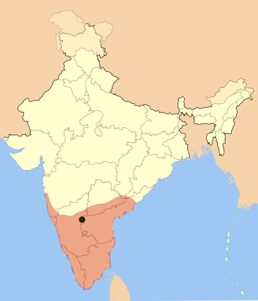
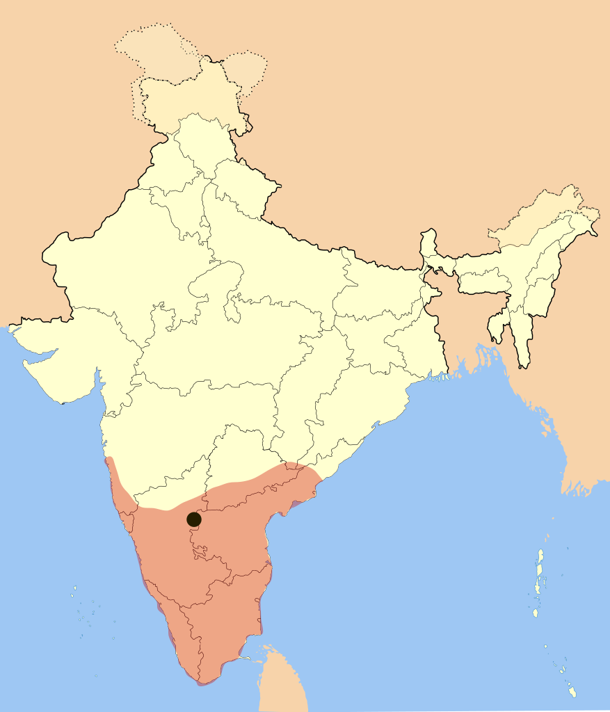
I used Image:India-locator-map-blank.svg as base and edited myself using Inkscape and created it by looking at the following sources.
Dr. Suryanath U. Kamath, A Concise history of Karnataka from pre-historic times to the present, Jupiter books, MCC, 2001 (Reprinted 2002) (page no - 329)
Durga Prasad, History Andhras upto 1565 A. D., 1988, P.G. Publishers, Don Bosco School Press, Guntur, p268-270(page no - 234)
I used Image:India-locator-map-blank.svg as base and edited myself using inkspace and created it by looking at the following sources. * Dr. Suryanath U. Kamath, A Concise history of Karnataka from pre-historic times to the present, Jupiter books, MC
== Summary == I used Image:India-locator-map-blank.svg as base and edited myself using inkspace and created it by looking at the following sources. * Dr. Suryanath U. Kamath, A Concise history of Karnataka from pre-historic times to the present, Jup
ไฟล, vijayanagara, empire, ไฟล, ประว, ไฟล, หน, าท, ภาพน, การใช, ไฟล, วนกลาง, อม, ลเก, ยวก, บภาพขนาดของต, วอย, าง, ของไฟล, กเซล, ความละเอ, ยดอ, กเซล, กเซล, กเซล, กเซล, กเซล, กเซล, ภาพท, ความละเอ, ยดส, งกว, 8206, ไฟล, กเซล, ขนาดไฟล, โลไบต, ปภาพหร, อไฟล, เส, ยงน,. ifl prawtiifl hnathimiphaphni karichiflswnklang khxmulekiywkbphaphkhnadkhxngtwxyang PNG nikhxngifl SVG ni 514 600 phikesl khwamlaexiydxun 206 240 phikesl 411 480 phikesl 658 768 phikesl 877 1 024 phikesl 1 755 2 048 phikesl 1 585 1 850 phikesl duphaphthimikhwamlaexiydsungkwa 8206 ifl SVG 1 585 1 850 phikesl khnadifl 372 kiolibt rupphaphhruxiflesiyngni tnchbbxyuthi khxmmxns raylaexiyddanlang epnkhxkhwamthiaesdngphlcak ifltnchbbinkhxmmxns khxmmxnsepnewbistinokhrngkarsahrbekbrwbrwmsuxesri thi khunsamarthchwyid rambabu khwamyx I used Image India locator map blank svg as base and edited myself using Inkscape and created it by looking at the following sources Dr Suryanath U Kamath A Concise history of Karnataka from pre historic times to the present Jupiter books MCC 2001 Reprinted 2002 page no 329 Durga Prasad History Andhras upto 1565 A D 1988 P G Publishers Don Bosco School Press Guntur p268 270 page no 234 and http www britannica com eb art 1959 Empire was under its peak when Goa was captured and won many portions of Andhra Pradesh from Gajapati s of Orissa Color and opacity are changed on May 27 2007 khaxthibayVijayanagara empire map svg Vijaya Nagara Empire Map wnthi 17 mkrakhm ph s 2550 aehlngthima ngankhxngtw phusrangsrrkh Mlpkr SVG nbsp genesisInfoField nbsp sxrsokhdkhxng SVG nitrwcsxbthuktxngaelw nbsp iflphaphkrafiksewketxrni srangkhunodyich nbsp Inkscape karxnuyatichsiththi khapheca inthanaphuthuxlikhsiththikhxngphaphhruxsuxni xnuyatihichphaphhruxsuxniphayitenguxnikhtxipni xnuyatihkhdlxk aeckcayaela hruxddaeprexksarniphayitenguxnikhkhxngsyyaxnuyatexksaresrikhxngknu run 1 2 hruxrunid nbcaknithixxkodymulnithisxftaewresri odyimmiswnidhamaekikh immikhxkhwampkhnaaelapkhlng saenakhxngsyyaxnuyatrwmxyuinswnchux syyaxnuyatexksaresrikhxngknuhttp www gnu org copyleft fdl html GFDL GNU Free Documentation License true true iflnixyuphayitsyyaxnuyat khriexthifkhxmmxns aebbaesdngthima xnuyataebbediywkn 3 0 tnchbb khunsamarth thicaaebngpn thicathasaena aeckcay aelasngngandngklawtxip thicaeriyberiyngihm thicaddaeplngngandngklaw phayitenguxnikhtxipni aesdngthima khuntxngihekiyrtiecakhxngnganxyangehmaasm odyephimlingkipyngsyyaxnuyat aelarabuhakmikarepliynaeplng khunxacthaechnniidinrupaebbidkidtamkhwr aettxngimichinlksnathiaenawaphuihxnuyatsnbsnunkhunhruxkarichngankhxngkhun xnuyataebbediywkn hakkhunddaeplng epliynrup hruxtxetimnganni khuntxngichsyyaxnuyataebbediywknhruxaebbthiehmuxnkbsyyaxnuyatthiichkbnganniethann payaesdngsthanalikhsiththinithukephimephuxihepniptamkarepliynaeplngsyyaxnuyatkhxngmulnithiwikimiediy cak GFDL ipyng GFDL khwbkhukb CC BY SA 3 0 http creativecommons org licenses by sa 3 0 CC BY SA 3 0 Creative Commons Attribution Share Alike 3 0 true trueiflnixyuphayitsyyaxnuyatkhriexthifkhxmmxns runaesdngthima xnuyataebbediywkn 2 5 thwip 2 0 thwip aela 1 0 thwipkhunsamarth thicaaebngpn thicathasaena aeckcay aelasngngandngklawtxip thicaeriyberiyngihm thicaddaeplngngandngklaw phayitenguxnikhtxipni aesdngthima khuntxngihekiyrtiecakhxngnganxyangehmaasm odyephimlingkipyngsyyaxnuyat aelarabuhakmikarepliynaeplng khunxacthaechnniidinrupaebbidkidtamkhwr aettxngimichinlksnathiaenawaphuihxnuyatsnbsnunkhunhruxkarichngankhxngkhun xnuyataebbediywkn hakkhunddaeplng epliynrup hruxtxetimnganni khuntxngichsyyaxnuyataebbediywknhruxaebbthiehmuxnkbsyyaxnuyatthiichkbnganniethannhttps creativecommons org licenses by sa 2 5 CC BY SA 2 5 Creative Commons Attribution Share Alike 2 5 true truekhunsamartheluxksyyaxnuyatdngklawtamtxngkarkhabrryayodyyxithyephimkhabrryaythrrthdediywephuxkhyaykhwamwaiflnimixairxngkvsPartial representation of Vijayanagara Kingdom regions of Odisha are not included in map bngklaব জয নগর স ম র জ য র ম নচ ত রhindiन ष द न यक सम र ज यthmilவ ஜயநகர ப ரரச ஒர ச பக த கள ன பக த ப ரத ந த த த வம வர படத த ல ச ர க கப படவ ல ல ixethmthiaesdngxyuiniflniprakxbdwyckrwrrdiwichynkhrphusrangbangkhathiimmiixethmwikisnethschuxphusrangsrrkh Mlpkrchuxphuichwikimiediy Mlpkryuxaraexl http commons wikimedia org wiki User MlpkrsthanalikhsiththimilikhsiththisyyaxnuyatCreative Commons Attribution ShareAlike 2 0 Generic nbsp xngkvsCreative Commons Attribution ShareAlike 2 5 Generic nbsp xngkvsGNU Free Documentation License version 1 2 or lateral nbsp xngkvsCreative Commons Attribution ShareAlike 1 0 Generic nbsp xngkvsCreative Commons Attribution ShareAlike 3 0 Unported nbsp xngkvswnthisrang wnkxtng17 mkrakhm 2007thimakhxngiflkarsrangdngedimodyphuxpohld prawtiifl khlikwnthi ewlaephuxduiflthipraktinkhnann wnthi ewlarupyxkhnadphuichkhwamehn pccubn03 09 4 minakhm 25601 585 1 850 372 kiolibt BurritoBazookarederive from new modern boundaries map Some state borders have changed Telangana 07 05 28 phvsphakhm 25501 651 1 753 432 kiolibt MlpkrI used Image India locator map blank svg as base and edited myself using inkspace and created it by looking at the following sources Dr Suryanath U Kamath A Concise history of Karnataka from pre historic times to the present Jupiter books MC 23 49 24 mkrakhm 25501 651 1 753 432 kiolibt MlpkrAll of the old copyrights with only difference adding a dot for the capitol 03 34 18 mkrakhm 25501 651 1 753 428 kiolibt Mlpkr Summary I used Image India locator map blank svg as base and edited myself using inkspace and created it by looking at the following sources Dr Suryanath U Kamath A Concise history of Karnataka from pre historic times to the present Jup hnathimiphaphni hnatxipni oyngmathiphaphni ckrwrrdiwichynkhr karichiflswnklang wikixuntxipniichiflni karichbn ast wikipedia org Imperiu vijayanagara karichbn azb wikipedia org ویجایاناقار ایمپیراتورلوغو karichbn ba wikipedia org In ҙur dәүlәttәr isemlege karichbn be wikipedia org Vidzhayanagarskaya imperyya karichbn bg wikipedia org Vidzhayanagara imperiya karichbn bn wikipedia org ব জয নগর স ম র জ য দ ব ত য দ ব র য karichbn br wikipedia org Vijayanagara karichbn ca wikipedia org Imperi de Vijayanagara karichbn cs wikipedia org Vidzajanagarska rise karichbn da wikipedia org Vijayanagar kongeriget karichbn de wikipedia org Vijayanagar karichbn en wikipedia org Vijayanagara Empire South India Carnatic expansion Deva Raya II Kadapa Telugu people Golden Age of India History of Karnataka Portal India Selected articles Archive Political history of medieval Karnataka Portal India SC Summary SA Vijayanagara Empire User Mattisse BoxD User ShivNarayanan User Tisquesusa sandbox9 karichbn en wikivoyage org Southern India karichbn eo wikipedia org Viĝajanagara imperio karichbn es wikipedia org Historia de la India Imperio vijayanagara Anexo Imperios por superficie Reino de Mysore Conquistas musulmanas en el subcontinente indio karichbn eu wikipedia org Vijayanagara Inperioa karichbn fa wikipedia org سلطان نشین بهمنی امپراتوری ویجایاناگارا karichbn fi wikipedia org Vijayanagara karichbn fr wikipedia org Royaume de Vijayanagara Conquetes musulmanes des Indes karichbn gl wikipedia org 1565 Decada de 1560 karichbn gu wikipedia org વ જયનગર સ મ ર જ ય karichbn he wikipedia org אימפריית ויג איאנגר karichbn hi wikipedia org व जयनगर स म र ज य सदस य Abishekrl15156 व जयनगर स म र ज य क स स क त karichbn hr wikipedia org Povijest Indije karichbn hu wikipedia org India uralkodoinak listaja karichbn hy wikipedia org Աշխարհի պատմության խոշորագույն տերությունների կայսրությունների ցանկ karichbn id wikipedia org Kemaharajaan Wijayanagara karichbn it wikipedia org Impero di Vijayanagara dukarichthwolkephimetimkhxngiflnikhxmulekiywkbphaph phaphnimikhxmulephimetim sungswnihymacakklxngdicitxlhruxsaeknenxrthisamarthekbkhxmuldngklawiwrwmkbphaphid thaphaphnithukprbprungaekikhhruxepliynaeplngcakedim khxmulbangxyangcayngkhngimepliynaeplngehmuxnphaphthithukprbprungaekikhnnkhwamkwang1585 0667khwamsung1849 6 ekhathungcak https th wikipedia org wiki ifl Vijayanagara empire map svg, wikipedia, วิกิ หนังสือ, หนังสือ, ห้องสมุด,