ภาพ meteorology นี้ ควรจะถูกสร้างใหม่เป็นกราฟิกส์เวกเตอร์ ซึ่งมีข้อดีอีกหลายประการ ดูเพิ่มเติมที่คอมมอนส์:สื่อต้องการเก็บกวาดสำหรับสารสนเทศเพิ่มเติม หากภาพนี้มีในรูปแบบกราฟิกส์เวกเตอร์อยู่แล้ว กรุณาอัปโหลดและแทนที่แม่แบบนี้ด้วย {{vector version available|ชื่อภาพใหม่}} แนะนำเป็นอย่างยิ่งให้ตั้งชื่อไฟล์เวกเตอร์ใหม่นั้นในรูปแบบ "World Köppen Map.svg" แล้วใส่แม่แบบ Vector version available (หรือ Vva) ซึ่งไม่ต้องใช้พารามิเตอร์ ชื่อภาพใหม่
This meteorology image was uploaded in the JPEG format even though it consists of non-photographic data. This information could be stored more efficiently or accurately in the PNG or SVG format. If possible, please upload a PNG or SVG version of this image without compression artifacts, derived from a non-JPEG source (or with existing artifacts removed). After doing so, please tag the JPEG version with {{Superseded|NewImage.ext}} and remove this tag. This tag should not be applied to photographs or scans. For more information, see {{BadJPEG}}.
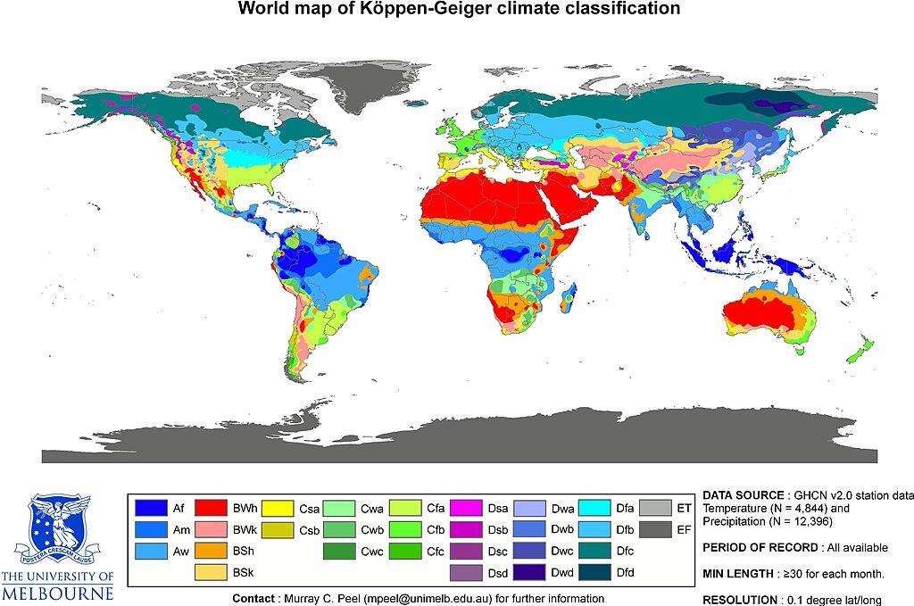
Peel, M. C. and Finlayson, B. L. and McMahon, T. A. (2007). "Updated world map of the Köppen-Geiger climate classification". Hydrol. Earth Syst. Sci.11: 1633-1644. ISSN 1027-5606.
This is the original JPG-file that is only uploaded as a reference. Please see/use the smaller PNG-file for thumbnailing etc...
ความย่อ
คำอธิบายWorld Köppen Map.jpg
Updated world map of the Köppen-Geiger climate classification.
วันที่
แหล่งที่มา
Hydrology and Earth System Sciences: "Updated world map of the Köppen-Geiger climate classification" (Supplement).
ผู้สร้างสรรค์
Peel, M. C., Finlayson, B. L., and McMahon, T. A. (University of Melbourne)
The Caspian coastal lowland of Iran has a humid subtropical climate (Köppen classification: Cfa). The Costa Rican Central Valley has a dry winter oceanic climate (Köppen classification: Cwb).
Köppen system is based on the concept that climate types are correlated with the natural vegetation. Large bodies of water such as seas (in this case Caspian Sea) are excluded.
Slight improvement in image quality as is possible for jpg files. Painted the Caspian Sea as white, because the Köppen system is based on the concept that climate types are correlated with the natural vegetation. Thus with Köppen, climate zone boundarie
Citation: '''Peel, M. C., Finlayson, B. L., and McMahon, T. A.: Updated world map of the Köppen-Geiger climate classification, Hydrol. Earth Syst. Sci., 11, 1633-1644, 2007.''' :This is the original JPG-file that is only uploaded as a reference. Please
ไฟล, world, köppen, ไฟล, ประว, ไฟล, หน, าท, ภาพน, การใช, ไฟล, วนกลาง, อม, ลเก, ยวก, บภาพขนาดของต, วอย, างน, กเซล, ความละเอ, ยดอ, กเซล, กเซล, กเซล, กเซล, กเซล, กเซล, ภาพท, ความละเอ, ยดส, งกว, 8206, กเซล, ขนาดไฟล, เมกะไบต, ชน, ดไมม, image, jpeg, ปภาพหร, อไฟล, เส. ifl prawtiifl hnathimiphaphni karichiflswnklang khxmulekiywkbphaphkhnadkhxngtwxyangni 800 530 phikesl khwamlaexiydxun 320 212 phikesl 640 424 phikesl 1 024 679 phikesl 1 280 848 phikesl 2 560 1 697 phikesl 4 231 2 804 phikesl duphaphthimikhwamlaexiydsungkwa 8206 4 231 2 804 phikesl khnadifl 1 25 emkaibt chnidimm image jpeg rupphaphhruxiflesiyngni tnchbbxyuthi khxmmxns raylaexiyddanlang epnkhxkhwamthiaesdngphlcak ifltnchbbinkhxmmxns khxmmxnsepnewbistinokhrngkarsahrbekbrwbrwmsuxesri thi khunsamarthchwyid phaph meteorology ni khwrcathuksrangihmepnkrafiksewketxr sungmikhxdixikhlayprakar duephimetimthikhxmmxns suxtxngkarekbkwadsahrbsarsnethsephimetim hakphaphnimiinrupaebbkrafiksewketxrxyuaelw krunaxpohldaelaaethnthiaemaebbnidwy vector version available i chuxphaphihm i aenanaepnxyangyingihtngchuxiflewketxrihmnninrupaebb World Koppen Map svg aelwisaemaebb Vector version available hrux Vva sungimtxngichpharamietxr chuxphaphihmThis meteorology image was uploaded in the JPEG format even though it consists of non photographic data This information could be stored more efficiently or accurately in the PNG or SVG format If possible please upload a PNG or SVG version of this image without compression artifacts derived from a non JPEG source or with existing artifacts removed After doing so please tag the JPEG version with Superseded NewImage ext and remove this tag This tag should not be applied to photographs or scans For more information see BadJPEG Peel M C and Finlayson B L and McMahon T A 2007 Updated world map of the Koppen Geiger climate classification Hydrol Earth Syst Sci 11 1633 1644 ISSN 1027 5606 enuxha 1 khwamyx 2 karxnuyatichsiththi This is the original JPG file that is only uploaded as a reference Please see use the smaller PNG file for thumbnailing etc khwamyx khaxthibayWorld Koppen Map jpg Updated world map of the Koppen Geiger climate classification wnthi 12 tulakhm ph s 2550aehlngthima Hydrology and Earth System Sciences Updated world map of the Koppen Geiger climate classification Supplement phusrangsrrkh Peel M C Finlayson B L and McMahon T A University of Melbourne karxnuyat karichiflniihm khxkhwamxnuyatcakecakhxnglikhsiththiihichnganphaphhruxsuxni idrbkartrwcsxbaelw aelathukekbiwinxasasmkhrtxbklbxieml VRT odysahrbphuichthimibychi VRT samarthtrwcsxbbnthukekiywkbkhxkhwamxnuyatnnid inbnthukhmayelkh 2011040110025998 hakthantxngkarnaphaphhruxsuxniipichthixunnxkehnuxcakinmulnithiwikimiediy krunaxankhxmulekiywkbkarnaenuxhaipichnxkmulnithiwikimiediythihnani thngnihakthanprasngkhcakhxkhayunynekiywkbkarxnuyatihichichphaphhruxsuxni krunatidtxphuichthimibychi VRT hruxaecngphanhnaaecng VRT lingkkhxngbnthuk https ticket wikimedia org otrs index pl Action AgentTicketZoom amp TicketNumber 2011040110025998 Find other files from the same ticket See Image World Koppen Map png for an improved map to use on Wikipedia and such karxnuyatichsiththi iflnixyuphayitsyyaxnuyat khriexthifkhxmmxns aebbaesdngthima xnuyataebbediywkn 2 5 thwipkhunsamarth thicaaebngpn thicathasaena aeckcay aelasngngandngklawtxip thicaeriyberiyngihm thicaddaeplngngandngklaw phayitenguxnikhtxipni aesdngthima khuntxngihekiyrtiecakhxngnganxyangehmaasm odyephimlingkipyngsyyaxnuyat aelarabuhakmikarepliynaeplng khunxacthaechnniidinrupaebbidkidtamkhwr aettxngimichinlksnathiaenawaphuihxnuyatsnbsnunkhunhruxkarichngankhxngkhun xnuyataebbediywkn hakkhunddaeplng epliynrup hruxtxetimnganni khuntxngichsyyaxnuyataebbediywknhruxaebbthiehmuxnkbsyyaxnuyatthiichkbnganniethannhttps creativecommons org licenses by sa 2 5 CC BY SA 2 5 Creative Commons Attribution Share Alike 2 5 true truekhabrryayodyyxithyephimkhabrryaythrrthdediywephuxkhyaykhwamwaiflnimixairixethmthiaesdngxyuiniflniprakxbdwysthanalikhsiththimilikhsiththisyyaxnuyatCreative Commons Attribution ShareAlike 2 5 Generic xngkvsWikimedia VRTS ticket number xngkvs2011040110025998wnthisrang wnkxtng12 tulakhm 2007 prawtiifl khlikwnthi ewlaephuxduiflthipraktinkhnann wnthi ewlarupyxkhnadphuichkhwamehn pccubn23 55 20 kumphaphnth 25614 231 2 804 1 25 emkaibt MaphobbyistThe Caspian coastal lowland of Iran has a humid subtropical climate Koppen classification Cfa The Costa Rican Central Valley has a dry winter oceanic climate Koppen classification Cwb 23 35 4 emsayn 25544 231 2 804 808 kiolibt MaphobbyistKoppen system is based on the concept that climate types are correlated with the natural vegetation Large bodies of water such as seas in this case Caspian Sea are excluded 13 40 1 emsayn 25546 708 4 443 4 73 emkaibt BidgeeReverted to version as of 22 42 12 October 2007 Please don 039 t override images 19 09 13 minakhm 25544 231 2 804 809 kiolibt MaphobbyistSlight improvement in image quality as is possible for jpg files Painted the Caspian Sea as white because the Koppen system is based on the concept that climate types are correlated with the natural vegetation Thus with Koppen climate zone boundarie 05 42 13 tulakhm 25506 708 4 443 4 73 emkaibt JeroenCitation 039 039 039 Peel M C Finlayson B L and McMahon T A Updated world map of the Koppen Geiger climate classification Hydrol Earth Syst Sci 11 1633 1644 2007 039 039 039 This is the original JPG file that is only uploaded as a reference Please hnathimiphaphni immihnaidoyngmathiphaphnikarichiflswnklang wikixuntxipniichiflni karichbn en wikipedia org Jaitpura Phulera karichbn fa wikipedia org نیکوزیا karichbn he wikipedia org טריפולי לוב karichbn pl wikipedia org Klimat kontynentalny karichbn sco wikipedia org Continental climate karichbn vi wikipedia org Jaipurkhxmulekiywkbphaph phaphnimikhxmulephimetim sungswnihymacakklxngdicitxlhruxsaeknenxrthisamarthekbkhxmuldngklawiwrwmkbphaphid thaphaphnithukprbprungaekikhhruxepliynaeplngcakedim khxmulbangxyangcayngkhngimepliynaeplngehmuxnphaphthithukprbprungaekikhnnkarcdwangphaphpkti ekhathungcak https th wikipedia org wiki ifl World Koppen Map jpg, wikipedia, วิกิ หนังสือ, หนังสือ, ห้องสมุด,