This file is a map of a municipality in Japan created and uploaded by Lincun on Japanese Wikipedia. It may also be a file based on one of these maps (see info in file history or author field for more info on later editors). Source:
English: Data used : Ministry of Land, Infrastructure, Transport and Tourism - National Land Numerical Information (Administrative Area (N03) / Lake (W09))
日本語: 使用データ : 国土交通省 国土数値情報(行政区域(N03)・湖沼(W09))
The original file was licensed {{GFDL}} and {{Cc-by-sa-3.0}}. See this category for more files like this. ป้ายนี้มิใช่ป้ายแสดงสถานะลิขสิทธิ์ ดังนั้นการระบุสถานะลิขสิทธิ์จึงต้องกระทำแยกต่างหาก ดูที่ Commons:Lincensing
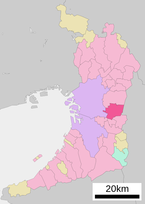
ไฟล, osaka, prefecture, ไฟล, ประว, ไฟล, หน, าท, ภาพน, การใช, ไฟล, วนกลาง, อม, ลเก, ยวก, บภาพขนาดของต, วอย, าง, ของไฟล, กเซล, ความละเอ, ยดอ, กเซล, กเซล, กเซล, กเซล, กเซล, กเซล, ภาพท, ความละเอ, ยดส, งกว, 8206, ไฟล, กเซล, ขนาดไฟล, โลไบต, ปภาพหร, อไฟล, เส, ยงน, นฉ. ifl prawtiifl hnathimiphaphni karichiflswnklang khxmulekiywkbphaphkhnadkhxngtwxyang PNG nikhxngifl SVG ni 426 600 phikesl khwamlaexiydxun 170 240 phikesl 341 480 phikesl 545 768 phikesl 727 1 024 phikesl 1 454 2 048 phikesl 490 690 phikesl duphaphthimikhwamlaexiydsungkwa 8206 ifl SVG 490 690 phikesl khnadifl 31 kiolibt rupphaphhruxiflesiyngni tnchbbxyuthi khxmmxns raylaexiyddanlang epnkhxkhwamthiaesdngphlcak ifltnchbbinkhxmmxns khxmmxnsepnewbistinokhrngkarsahrbekbrwbrwmsuxesri thi khunsamarthchwyid khwamyx khaxthibayYao in Osaka Prefecture Ja svg English Location of Yao in Osaka Prefecture 日本語 ja 大阪府八尾市位置図wnthi 5 tulakhm ph s 2550 13 38 UTC aehlngthima Original file ngankhxngtw Data 国土交通省 国土数値情報 行政区域 N03 湖沼 W09 phusrangsrrkh Lincunkarxnuyat karichiflniihm This file is a map of a municipality in Japan created and uploaded by Lincun on Japanese Wikipedia It may also be a file based on one of these maps see info in file history or author field for more info on later editors Source English Data used Ministry of Land Infrastructure Transport and Tourism National Land Numerical Information Administrative Area N03 Lake W09 日本語 使用データ 国土交通省 国土数値情報 行政区域 N03 湖沼 W09 The original file was licensed GFDL and Cc by sa 3 0 See this category for more files like this paynimiichpayaesdngsthanalikhsiththi dngnnkarrabusthanalikhsiththicungtxngkrathaaeyktanghak duthi Commons Lincensing karxnuyatichsiththi xnuyatihkhdlxk aeckcayaela hruxddaeprexksarniphayitenguxnikhkhxngsyyaxnuyatexksaresrikhxngknu run 1 2 hruxrunid nbcaknithixxkodymulnithisxftaewresri odyimmiswnidhamaekikh immikhxkhwampkhnaaelapkhlng saenakhxngsyyaxnuyatrwmxyuinswnchux syyaxnuyatexksaresrikhxngknuhttp www gnu org copyleft fdl html GFDL GNU Free Documentation License true trueiflnixyuphayitsyyaxnuyat khriexthifkhxmmxns aebbaesdngthima xnuyataebbediywkn 3 0 tnchbbkhunsamarth thicaaebngpn thicathasaena aeckcay aelasngngandngklawtxip thicaeriyberiyngihm thicaddaeplngngandngklaw phayitenguxnikhtxipni aesdngthima khuntxngihekiyrtiecakhxngnganxyangehmaasm odyephimlingkipyngsyyaxnuyat aelarabuhakmikarepliynaeplng khunxacthaechnniidinrupaebbidkidtamkhwr aettxngimichinlksnathiaenawaphuihxnuyatsnbsnunkhunhruxkarichngankhxngkhun xnuyataebbediywkn hakkhunddaeplng epliynrup hruxtxetimnganni khuntxngichsyyaxnuyataebbediywknhruxaebbthiehmuxnkbsyyaxnuyatthiichkbnganniethannhttps creativecommons org licenses by sa 3 0 CC BY SA 3 0 Creative Commons Attribution Share Alike 3 0 true true bnthukkarxphohld This file was moved from Japanese Wikipedia See below for original file information File name 基礎自治体位置図 27212 svgDescription 基礎自治体位置図画像情報 大阪府 八尾市 File history wnthi ewla UTC khnad phuich khwamehn5 tulakhm ph s 2550 13 38 42 500x772 Lincun 基礎自治体位置図画像情報 大阪府 八尾市 Page history wnthi ewla UTC Flag phuich khwamyx 5 tulakhm ph s 2550 13 38 43 Lincun 基礎自治体位置図画像情報 大阪府 八尾市 Deutsch English makedonski 한국어 日本語 فارسی khabrryayodyyxithyephimkhabrryaythrrthdediywephuxkhyaykhwamwaiflnimixairixethmthiaesdngxyuiniflniprakxbdwysthanalikhsiththimilikhsiththisyyaxnuyatGNU Free Documentation License version 1 2 or later xngkvsCreative Commons Attribution ShareAlike 3 0 Unported xngkvsMIME type xngkvsimage svg xml prawtiifl khlikwnthi ewlaephuxduiflthipraktinkhnann wnthi ewlarupyxkhnadphuichkhwamehn pccubn15 49 22 tulakhm 2563490 690 31 kiolibt AichiWikiFixerUpdated as File Map of Osaka Prefecture Ja svg 15 42 10 tulakhm 2552500 772 16 kiolibt Monaneko Information Description en 1 Location of Yao in Osaka Prefecture ja 1 大阪府八尾市の位置 Source ja File 基礎自治体位置図 27212 svg Author ja User Lincun Date 2007 10 05 13 38 UTC Permission other versions 20 38 5 tulakhm 2550500 772 16 kiolibt Lincun 基礎自治体位置図画像情報 大阪府 八尾市 hnathimiphaphni hnatxipni oyngmathiphaphni yaoxa karichiflswnklang wikixuntxipniichiflni karichbn ar wikipedia org ياو أوساكا karichbn ca wikipedia org Yao Osaka karichbn ce wikipedia org Yao Osaka karichbn en wikipedia org Osaka Prefecture Core cities of Japan Yao Osaka karichbn eo wikipedia org Jao karichbn es wikipedia org Yao Osaka karichbn fa wikipedia org یائو اوساکا karichbn fi wikipedia org Yao karichbn fr wikipedia org Yao Osaka karichbn ga wikipedia org Yao karichbn id wikipedia org Yao Osaka karichbn ja wikipedia org 八尾市 karichbn ko wikipedia org 야오시 karichbn ms wikipedia org Yao Osaka karichbn nl wikipedia org Yao Osaka karichbn ro wikipedia org Yao municipiu karichbn sco wikipedia org Yao Osaka karichbn sh wikipedia org Yao Osaka karichbn simple wikipedia org Yao Osaka karichbn sr wikipedia org Јao karichbn sv wikipedia org Yao Osaka karichbn tg wikipedia org Yao karichbn tt wikipedia org Yao Osaka karichbn uk wikipedia org Yao Osaka karichbn ur wikipedia org یاو اوساکا karichbn vi wikipedia org Yao karichbn www wikidata org Q490872 karichbn zh min nan wikipedia org Yao chhi karichbn zh wikipedia org 八尾市khxmulekiywkbphaph phaphnimikhxmulephimetim sungswnihymacakklxngdicitxlhruxsaeknenxrthisamarthekbkhxmuldngklawiwrwmkbphaphid thaphaphnithukprbprungaekikhhruxepliynaeplngcakedim khxmulbangxyangcayngkhngimepliynaeplngehmuxnphaphthithukprbprungaekikhnnchuxeruxngsn大阪府区画図khwamkwang490khwamsung690 ekhathungcak https th wikipedia org wiki ifl Yao in Osaka Prefecture Ja svg, wikipedia, วิกิ หนังสือ, หนังสือ, ห้องสมุด,