This file is licensed under the Creative Commons Attribution-Share Alike 4.0 International, 3.0 Unported, 2.5 Generic, 2.0 Generic and 1.0 Generic license.
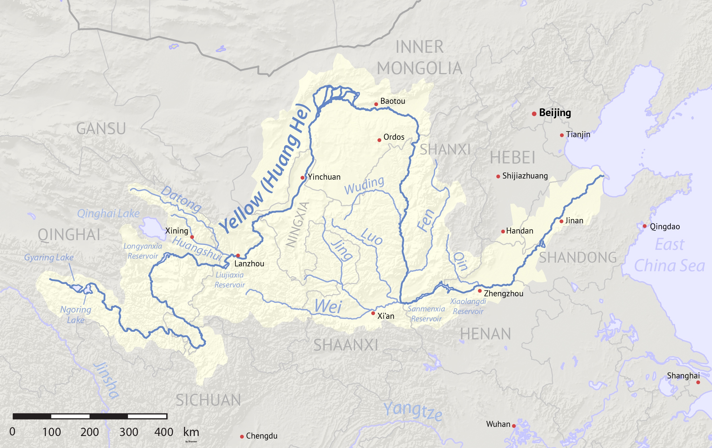
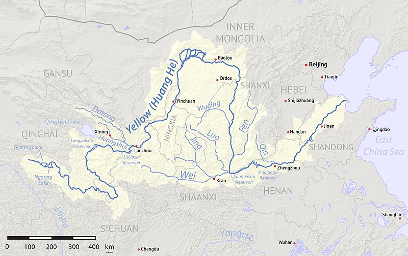
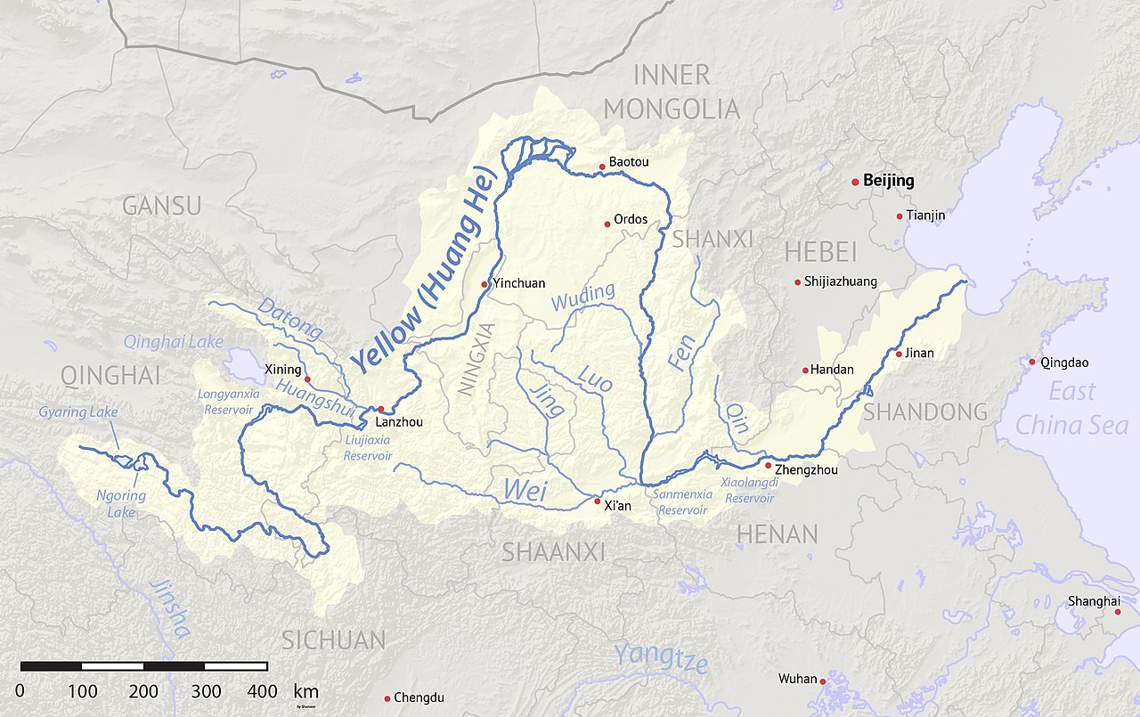
{{Information |Description={{en|1=Map of the Yellow River, whose watershed covers most of northern China and drains to the Bohai Sea}} |Source=Background and river course data from http://www2.demis.nl/mapserver/mapper.asp |Author=[[User:Shannonchan|Shan
ไฟล, yellowrivermap, ไฟล, ประว, ไฟล, หน, าท, ภาพน, การใช, ไฟล, วนกลาง, อม, ลเก, ยวก, บภาพขนาดของต, วอย, างน, กเซล, ความละเอ, ยดอ, กเซล, กเซล, กเซล, กเซล, กเซล, ภาพท, ความละเอ, ยดส, งกว, 8206, กเซล, ขนาดไฟล, เมกะไบต, ชน, ดไมม, image, jpeg, ปภาพหร, อไฟล, เส, ยงน. ifl prawtiifl hnathimiphaphni karichiflswnklang khxmulekiywkbphaphkhnadkhxngtwxyangni 800 503 phikesl khwamlaexiydxun 320 201 phikesl 640 403 phikesl 1 024 644 phikesl 1 280 805 phikesl 2 497 1 571 phikesl duphaphthimikhwamlaexiydsungkwa 8206 2 497 1 571 phikesl khnadifl 1 19 emkaibt chnidimm image jpeg rupphaphhruxiflesiyngni tnchbbxyuthi khxmmxns raylaexiyddanlang epnkhxkhwamthiaesdngphlcak ifltnchbbinkhxmmxns khxmmxnsepnewbistinokhrngkarsahrbekbrwbrwmsuxesri thi khunsamarthchwyid khwamyx khaxthibayYellowrivermap jpg English Map of the Yellow River whose watershed covers most of northern China and drains to the Yellow Seawnthi 1 minakhm ph s 2553 2017 08 10 revised aehlngthima Created using Natural Earth and NASA SRTM data both public domain phusrangsrrkh Shannon1ewxrchnxun iflxunthiichiflni Yellowrivermap 2 jpg Yellowrivermap zh hans jpg Yellowrivermap zh hant jpg karxnuyatichsiththi khapheca inthanaphuthuxlikhsiththikhxngphaphhruxsuxni xnuyatihichphaphhruxsuxniphayitenguxnikhtxipni xnuyatihkhdlxk aeckcayaela hruxddaeprexksarniphayitenguxnikhkhxngsyyaxnuyatexksaresrikhxngknu run 1 2 hruxrunid nbcaknithixxkodymulnithisxftaewresri odyimmiswnidhamaekikh immikhxkhwampkhnaaelapkhlng saenakhxngsyyaxnuyatrwmxyuinswnchux syyaxnuyatexksaresrikhxngknuhttp www gnu org copyleft fdl html GFDL GNU Free Documentation License true trueThis file is licensed under the Creative Commons Attribution Share Alike 4 0 International 3 0 Unported 2 5 Generic 2 0 Generic and 1 0 Generic license khunsamarth thicaaebngpn thicathasaena aeckcay aelasngngandngklawtxip thicaeriyberiyngihm thicaddaeplngngandngklaw phayitenguxnikhtxipni aesdngthima khuntxngihekiyrtiecakhxngnganxyangehmaasm odyephimlingkipyngsyyaxnuyat aelarabuhakmikarepliynaeplng khunxacthaechnniidinrupaebbidkidtamkhwr aettxngimichinlksnathiaenawaphuihxnuyatsnbsnunkhunhruxkarichngankhxngkhun xnuyataebbediywkn hakkhunddaeplng epliynrup hruxtxetimnganni khuntxngichsyyaxnuyataebbediywknhruxaebbthiehmuxnkbsyyaxnuyatthiichkbnganniethannhttps creativecommons org licenses by sa 4 0 CC BY SA 4 0 Creative Commons Attribution Share Alike 4 0 true truekhunsamartheluxksyyaxnuyatdngklawtamtxngkarkhabrryayodyyxithyephimkhabrryaythrrthdediywephuxkhyaykhwamwaiflnimixairixethmthiaesdngxyuiniflniprakxbdwyphusrangbangkhathiimmiixethmwikisnethschuxphusrangsrrkh Shannon1yuxaraexl https commons wikimedia org wiki user Shannon1chuxphuichwikimiediy Shannon1hnathikhxngwtthuphayitpraphcnni changphaphsthanalikhsiththimilikhsiththisyyaxnuyatCreative Commons Attribution ShareAlike 1 0 Generic xngkvsCreative Commons Attribution ShareAlike 3 0 Unported xngkvsCreative Commons Attribution ShareAlike 4 0 International xngkvsCreative Commons Attribution ShareAlike 2 5 Generic xngkvsGNU Free Documentation License version 1 2 or later xngkvsCreative Commons Attribution ShareAlike 2 0 Generic xngkvswnthisrang wnkxtng1 minakhm 2010 prawtiifl khlikwnthi ewlaephuxduiflthipraktinkhnann wnthi ewlarupyxkhnadphuichkhwamehn pccubn11 17 11 singhakhm 25602 497 1 571 1 19 emkaibt Shannon1Uploaded clearer version with corrected data 09 23 2 minakhm 25531 100 544 401 kiolibt Shannon1 Information Description en 1 Map of the Yellow River whose watershed covers most of northern China and drains to the Bohai Sea Source Background and river course data from http www2 demis nl mapserver mapper asp Author User Shannonchan Shan hnathimiphaphni hnatxipni oyngmathiphaphni raychuxaemnainpraethscin aemnahwng aemnahwngchuy karichiflswnklang wikixuntxipniichiflni karichbn af wikipedia org Geelrivier karichbn als wikipedia org Gelber Fluss karichbn an wikipedia org Rio Amariello karichbn ary wikipedia org لواد الصفر karichbn ast wikipedia org Xining Lanzhou Shijiazhuang Zhengzhou Jinan Qingdao karichbn as wikipedia org হ ৱ হ নদ karichbn azb wikipedia org ساری چای karichbn bar wikipedia org Gejba Fluss karichbn ba wikipedia org Huanhe karichbn bcl wikipedia org Salog Giyaw karichbn be tarask wikipedia org Huanhe karichbn bg wikipedia org Huanh Guandzhun Fnh Spisk na rekite v Kitaj karichbn bh wikipedia org ह व ग ह karichbn bn wikipedia org হ য হ নদ karichbn bo wikipedia org ར ཆ karichbn br wikipedia org Ster Velen karichbn bxr wikipedia org Shara mүren karichbn ca wikipedia org Alashan karichbn ceb wikipedia org Ordos Gaoyuan karichbn cs wikipedia org Zluta reka karichbn de wikipedia org Gelber Fluss Fen He Tao He karichbn diq wikipedia org Cografyay Asya karichbn en wikipedia org Yellow River List of rivers of China Fen River User Shannon1 Maps Ordos Plateau Talk 2011 China floods Qin s campaign against the Xiongnu Yellow River Map Datong River Huangshui River Yellow River civilization History of the eastern steppe User Shannon1 Maps to do Portal Civilizations karichbn en wikivoyage org Along the Yellow River karichbn eo wikipedia org Flava Rivero Fen karichbn es wikipedia org Lanzhou dukarichthwolkephimetimkhxngiflnikhxmulekiywkbphaph phaphnimikhxmulephimetim sungswnihymacakklxngdicitxlhruxsaeknenxrthisamarthekbkhxmuldngklawiwrwmkbphaphid thaphaphnithukprbprungaekikhhruxepliynaeplngcakedim khxmulbangxyangcayngkhngimepliynaeplngehmuxnphaphthithukprbprungaekikhnnkarcdwangphaphpktikhwamlaexiydaenwnxn300 dpikhwamlaexiydaenwtng300 dpisxftaewrthiichAdobe ImageReadysepssisRGB ekhathungcak https th wikipedia org wiki ifl Yellowrivermap jpg, wikipedia, วิกิ หนังสือ, หนังสือ, ห้องสมุด,